
Schwarzwald-Querweg Freiburg-Bodensee
Encyclopedia
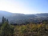
The Schwarzwald-Querweg Freiburg-Bodensee is a long-distance footpath that runs in an east–west direction in the Black Forest
region of Baden-Württemberg
, Germany
.
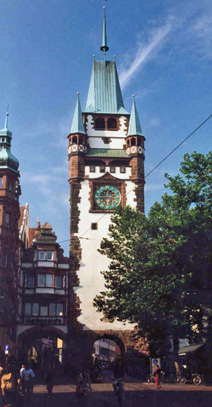 Its western end is the city of Freiburg
, in the Rhine valley; its eastern end is the city of Konstanz
, on Lake Constance
(German name: Bodensee). The name Querweg means "cross route", referring to the fact that the classic long-distance routes in the Black Forest, which were developed in the early 20th century, run north–south. The Querweg (as it is briefly known) was developed in the mid-1930s. The longer name is used to distinguish this path from other east–west routes in the Black Forest.
Available guide books (e.g. Bremke, 1999) describe walking the route in the west–east direction, which leads to sharp climbs on the first one or two days and then more gradual descents for the rest of the route. From Freiburg, the route passes through Stegen
, Buchenbach
, Hinterzarten
, Titisee-Neustadt
, Kappel (part of the municipality of Lenzkirch
), the Wutachschlucht, Blumberg
, Engen
and Singen
. Its total length is approximately 180 kilometres (111.8 mi). Its highest point is 1192 metres (3,910.8 ft), at the Hochfirst Tower
, just north of the village of Saig in the Lenzkirch municipality. Because the path cuts across the Black Forest, and then continues across the volcanically formed Hegau
region before skirting Lake Constance in its final section, it offers a great variety of landscape and vegetation.

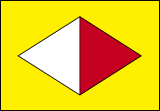 The route is very well marked throughout its length, using a waymark of a red and white lozenge (divided vertically, and with its longer axis horizontal) on a yellow background. According to Bremke (1999), the original planners of the route intended that the red end should always point towards Konstanz and the white towards Freiburg; this rule is generally but not universally obeyed in the waymarking in place .
. The route can be accessed at numerous places along its length by road or public transport, so it is easy to walk part of it or to do day walks along its route: the section through the Wutachschlucht is particularly popular for this.
For the eastern part of its length, from the Wutachschlucht to Konstanz, the Querweg route is followed by the European walking route E1
. The E1 has no separate waymarking, although occasional notices record that its route is being followed. The Querweg intersects all three of the main north-south Black Forest long distance paths, the Westweg
at Titisee, the Mittelweg at Hochfirst, and the Ostweg at Achdorf
.
Black Forest
The Black Forest is a wooded mountain range in Baden-Württemberg, southwestern Germany. It is bordered by the Rhine valley to the west and south. The highest peak is the Feldberg with an elevation of 1,493 metres ....
region of Baden-Württemberg
Baden-Württemberg
Baden-Württemberg is one of the 16 states of Germany. Baden-Württemberg is in the southwestern part of the country to the east of the Upper Rhine, and is the third largest in both area and population of Germany's sixteen states, with an area of and 10.7 million inhabitants...
, Germany
Germany
Germany , officially the Federal Republic of Germany , is a federal parliamentary republic in Europe. The country consists of 16 states while the capital and largest city is Berlin. Germany covers an area of 357,021 km2 and has a largely temperate seasonal climate...
.
Freiburg
Freiburg im Breisgau is a city in Baden-Württemberg, Germany. In the extreme south-west of the country, it straddles the Dreisam river, at the foot of the Schlossberg. Historically, the city has acted as the hub of the Breisgau region on the western edge of the Black Forest in the Upper Rhine Plain...
, in the Rhine valley; its eastern end is the city of Konstanz
Konstanz
Konstanz is a university city with approximately 80,000 inhabitants located at the western end of Lake Constance in the south-west corner of Germany, bordering Switzerland. The city houses the University of Konstanz.-Location:...
, on Lake Constance
Lake Constance
Lake Constance is a lake on the Rhine at the northern foot of the Alps, and consists of three bodies of water: the Obersee , the Untersee , and a connecting stretch of the Rhine, called the Seerhein.The lake is situated in Germany, Switzerland and Austria near the Alps...
(German name: Bodensee). The name Querweg means "cross route", referring to the fact that the classic long-distance routes in the Black Forest, which were developed in the early 20th century, run north–south. The Querweg (as it is briefly known) was developed in the mid-1930s. The longer name is used to distinguish this path from other east–west routes in the Black Forest.
Available guide books (e.g. Bremke, 1999) describe walking the route in the west–east direction, which leads to sharp climbs on the first one or two days and then more gradual descents for the rest of the route. From Freiburg, the route passes through Stegen
Stegen
Stegen is a small town in the commune of "Aerenzdallgemeng", in eastern Luxembourg. , the town has a population of 395....
, Buchenbach
Buchenbach
Buchenbach is a municipality in the south west of the Black Forest. It is located in the district of Breisgau-Hochschwarzwald in Baden-Württemberg in Germany. It is made up of four communities, the main town of Buchenbach and the villages of Falkensteig, Unteribental and Wagensteig...
, Hinterzarten
Hinterzarten
Hinterzarten is a resort village in the Black Forest , located in the southwest of the state of Baden-Württemberg, Germany. Although Hinterzarten is mostly famous for its ski jumpers, it also has many tourist attractions .- Hinterzarten :Hinterzarten was founded in 1148...
, Titisee-Neustadt
Titisee-Neustadt
Titisee-Neustadt is a municipality in the district of Breisgau-Hochschwarzwald in Baden-Württemberg in southern Germany. It is made up of the six communities of Neustadt, Langenordnach, Rudenberg, Titisee, Schwärzenbach and Waldau.The town of Neustadt is a spa known for its Kneipp hydrotherapeutic...
, Kappel (part of the municipality of Lenzkirch
Lenzkirch
Lenzkirch is a municipality in the Black Forest. It lies in the district of Breisgau-Hochschwarzwald in Baden-Württemberg in Germany.-Geography:...
), the Wutachschlucht, Blumberg
Blumberg
Blumberg is a municipality situated in the Schwarzwald-Baar region of Baden-Württemberg, Germany, 19 kilometres south of Donaueschingen, on the southern edge of the Schwarzwald, The Black Forest and lying directly on the border with Switzerland’s Canton of Schaffhausen.-History:The town of Blumberg...
, Engen
Engen, Germany
Engen is a town in the district of Konstanz, in Baden-Württemberg, Germany. It is situated 12 km northwest of Singen, and 15 km south of Tuttlingen....
and Singen
Singen
Singen is an industrial city in the very south of Baden-Württemberg in southern Germany and just north of the German-Swiss border.-Location:...
. Its total length is approximately 180 kilometres (111.8 mi). Its highest point is 1192 metres (3,910.8 ft), at the Hochfirst Tower
Hochfirst Tower
Hochfirst Tower is a 25 metre tall lattice observation tower on the Hochfirst mountain near Titisee-Neustadt at 47°54'04" N and 8°11'03" E.It was built in 1890 as the replacement to a wooden observation tower...
, just north of the village of Saig in the Lenzkirch municipality. Because the path cuts across the Black Forest, and then continues across the volcanically formed Hegau
Hegau
The Hegau is a formerly volcanic landscape in southern Germany extending around the industrial city of Singen , between Lake Constance in the east, the Rhine River in the south, the Danube River in the north and the Randen—as the southwestern mountains of the Swabian Alb are called—in the west.The...
region before skirting Lake Constance in its final section, it offers a great variety of landscape and vegetation.
Waymark
The route is very well marked throughout its length, using a waymark of a red and white lozenge (divided vertically, and with its longer axis horizontal) on a yellow background. According to Bremke (1999), the original planners of the route intended that the red end should always point towards Konstanz and the white towards Freiburg; this rule is generally but not universally obeyed in the waymarking in place .Access and accommodation
The route passes through or near numerous villages or small towns, so there is no difficulty in finding overnight accommodation and meals along the route. It would require more planning to walk it while staying in youth hostel-type accommodation, or campingCamping
Camping is an outdoor recreational activity. The participants leave urban areas, their home region, or civilization and enjoy nature while spending one or several nights outdoors, usually at a campsite. Camping may involve the use of a tent, caravan, motorhome, cabin, a primitive structure, or no...
. The route can be accessed at numerous places along its length by road or public transport, so it is easy to walk part of it or to do day walks along its route: the section through the Wutachschlucht is particularly popular for this.
For the eastern part of its length, from the Wutachschlucht to Konstanz, the Querweg route is followed by the European walking route E1
European walking route E1
The E1 European long distance path, or just E1 path, is one of the European long-distance paths with a total length of some 4,960 km. It begins in Sweden, and crosses the Kattegat between Sweden and Denmark by ferry. It passes through Denmark, Germany and Switzerland to finish at Scapoli, Italy...
. The E1 has no separate waymarking, although occasional notices record that its route is being followed. The Querweg intersects all three of the main north-south Black Forest long distance paths, the Westweg
Westweg
The Westweg, , is a long-distance hiking trail running north-south through the Black Forest from Pforzheim to Basel. The trail is around 285 kilometres long, and was founded in 1900. It is currently maintained under the auspices of the Schwarzwaldverein...
at Titisee, the Mittelweg at Hochfirst, and the Ostweg at Achdorf
Blumberg
Blumberg is a municipality situated in the Schwarzwald-Baar region of Baden-Württemberg, Germany, 19 kilometres south of Donaueschingen, on the southern edge of the Schwarzwald, The Black Forest and lying directly on the border with Switzerland’s Canton of Schaffhausen.-History:The town of Blumberg...
.