
Schreckhorn
Encyclopedia
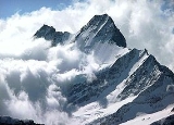
The Schreckhorn is a mountain
in the Bernese
Alps
. It is the highest peak located entirely in the canton of Berne
. The Schreckhorn is the northernmost Alpine four-thousander and the northernmost summit rising above 4,000 metres in Europe.
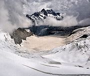
between the Upper
and Lower Grindelwald Glacier
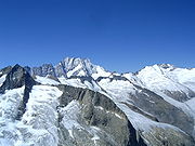
. The region is made up of uninhabited glacial valleys, the great Aar Glaciers
and the Fiescher Glacier
. The summit of the Lauteraarhorn
is located very close and reaches almost the same altitude. The highest peak of the Bernese Alps, the Finsteraarhorn
lies 10 km to the south.
Geologically the Schreckhorn is part of the Aarmassif
.
 The first ascent was on 16 August 1861 by Leslie Stephen
, Ulrich Kaufmann, Christian Michel and Peter Michel. Their route of ascent, via the upper Schreck Couloir to the Schrecksattel and then by the south-east ridge, was the normal route for the following fifty years, but is now seldom used.
The peak had been attempted several times before this, most notably by the Swiss naturalist Joseph Hugi in 1828 (the Schreckhorn's Hugisattel is named after him) and the guided party of Pierre Jean Édouard Desor
(a Swiss geologist) in 1842. 'The ambition of hoisting the first flag on the Schreckhorn, the one big Bernese summit which was untrodden, was far too obvious for us to resist', Desor later wrote, but they climbed a secondary summit of the Lauteraarhorn
by mistake.
The first ascent by the south-west ridge (AD+) – the normal route by which the Schreckhorn is climbed – was made by John Wicks, Edward Branby and Claude Wilson on 26 July 1902. They decided to climb the very steep ridge without the help of local guides and succeeded in reaching the summit. The north-west ridge (the Andersongrat, D) was first climbed by John Stafford Anderson and George Percival Baker, with guides Ulrich Almer and Aloys Pollinger on 7 August 1883.
 The Strahlegg Hut, destroyed by an avalanche, has been replaced by the Schreckhorn Hut (2,520 m). The Schreckhorn may also be ascended from the Gleckstein Hut (2,317 m) and the Lauteraar Hut (2,392 m).
Mountain
Image:Himalaya_annotated.jpg|thumb|right|The Himalayan mountain range with Mount Everestrect 58 14 160 49 Chomo Lonzorect 200 28 335 52 Makalurect 378 24 566 45 Mount Everestrect 188 581 920 656 Tibetan Plateaurect 250 406 340 427 Rong River...
in the Bernese
Bernese Alps
The Bernese Alps are a group of mountain ranges in the western part of the Alps, in Switzerland. Although the name suggests that they are located in the Bernese Oberland region of the canton of Bern, portions of the Bernese Alps are in the adjacent cantons of Valais, Lucerne, Obwalden, Fribourg and...
Alps
Swiss Alps
The Swiss Alps are the portion of the Alps mountain range that lies within Switzerland. Because of their central position within the entire Alpine range, they are also known as the Central Alps....
. It is the highest peak located entirely in the canton of Berne
Canton of Berne
The Canton of Bern is the second largest of the 26 Swiss cantons by both surface area and population. Located in west-central Switzerland, it borders the Canton of Jura and the Canton of Solothurn to the north. To the west lie the Canton of Neuchâtel, the Canton of Fribourg and Vaud. To the south...
. The Schreckhorn is the northernmost Alpine four-thousander and the northernmost summit rising above 4,000 metres in Europe.
Geography
The Schreckhorn is located 10 km south-east of GrindelwaldGrindelwald
Grindelwald is a municipality in the Interlaken-Oberhasli administrative district in the canton of Bern in Switzerland. The village is located at above sea level in the Bernese Alps.-Winter sports:...
between the Upper
Upper Grindelwald Glacier
The Upper Grindelwald Glacier is one of the two valley glaciers south of Grindelwald on the northern side of the Bernese Alps, in the Canton of Berne...
and Lower Grindelwald Glacier
Lower Grindelwald Glacier
The Lower Grindelwald Glacier is the western one and the largest of the two Grindelwald Glaciers in the Bernese Alps, south of Grindelwald, the other being the Upper Grindelwald Glacier.The Lower Grindelwald Glacier covers an area of ....
. The region is made up of uninhabited glacial valleys, the great Aar Glaciers
Aar Glaciers
The Aar Glaciers are glaciers located at the sources of the Aar River in the Bernese Alps, Switzerland. They are constituted by two distinct glacier systems:...
and the Fiescher Glacier
Fiescher Glacier
The Fiescher Glacier is a valley glacier on the south side of the Bernese Alps in the canton of Valais, Switzerland. in length, it is the second longest glacier in the Alps...
. The summit of the Lauteraarhorn
Lauteraarhorn
The Lauteraarhorn is a peak of the Aarmassif in the Bernese Alps in Switzerland. It lies close to the Schreckhorn and the Finsteraarhorn...
is located very close and reaches almost the same altitude. The highest peak of the Bernese Alps, the Finsteraarhorn
Finsteraarhorn
The Finsteraarhorn is the highest mountain in the Bernese Alps and the highest mountain in the canton of Berne. It is also the highest summit in the Alps lying outside the main chain, or watershed. The Finsteraarhorn is the ninth highest and third most prominent peak in the Alps...
lies 10 km to the south.
Geologically the Schreckhorn is part of the Aarmassif
Aarmassif
The Aarmassif or Aaremassif is a geologic massif in the Swiss Alps. It contains a number of large mountain chains and parts of mountain chains.-Geography:...
.
Climbing history
Leslie Stephen
Sir Leslie Stephen, KCB was an English author, critic and mountaineer, and the father of Virginia Woolf and Vanessa Bell.-Life:...
, Ulrich Kaufmann, Christian Michel and Peter Michel. Their route of ascent, via the upper Schreck Couloir to the Schrecksattel and then by the south-east ridge, was the normal route for the following fifty years, but is now seldom used.
The peak had been attempted several times before this, most notably by the Swiss naturalist Joseph Hugi in 1828 (the Schreckhorn's Hugisattel is named after him) and the guided party of Pierre Jean Édouard Desor
Pierre Jean Édouard Desor
Pierre Jean Édouard Desor was a Swiss geologist. He associated in his early years with Louis Agassiz, studying palaeontology and glacial phenomena, and together with James David Forbes ascended the Jungfrau in 1841...
(a Swiss geologist) in 1842. 'The ambition of hoisting the first flag on the Schreckhorn, the one big Bernese summit which was untrodden, was far too obvious for us to resist', Desor later wrote, but they climbed a secondary summit of the Lauteraarhorn
Lauteraarhorn
The Lauteraarhorn is a peak of the Aarmassif in the Bernese Alps in Switzerland. It lies close to the Schreckhorn and the Finsteraarhorn...
by mistake.
The first ascent by the south-west ridge (AD+) – the normal route by which the Schreckhorn is climbed – was made by John Wicks, Edward Branby and Claude Wilson on 26 July 1902. They decided to climb the very steep ridge without the help of local guides and succeeded in reaching the summit. The north-west ridge (the Andersongrat, D) was first climbed by John Stafford Anderson and George Percival Baker, with guides Ulrich Almer and Aloys Pollinger on 7 August 1883.
Further reading
- Smythe, Frank S., 'A Storm on the Schreckhorn', in Peaks, Passes and Glaciers, ed. W. Unsworth, London: Allen Lane, 1981. An attempt on the south-west ridge in 1925.