
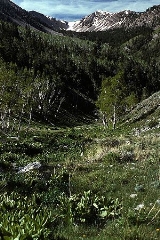
Schell Creek Range
Encyclopedia
The Schell Creek Range is a linear mountain range in central White Pine County
, in east-central Nevada
. Its length is approximately 132 miles (212.4 km) in a north-south direction.
The range comprises two major groups of peaks. The southern section rises from a point near Burnt Peak in Lincoln County
, reaching the summit of Mt. Grafton
, 10990 feet (3,349.8 m), just north of the border with White Pine County. To the west are remote Cave Valley and the Egan Range
, while to the east are U.S. Route 93 and the Fairview Range (Lincoln County)
. North of Mt. Grafton, the range drops quickly to a line of lower summits, eventually reaching 7723 feet (2,354 m) Connors Pass. That is where U.S. Route 50, the "Loneliest Highway in America", crosses the range, connecting the nearby community of Ely
with the Great Basin National Park
and west-central Utah
.
North of Connors Pass the range continues into its higher northern section. To the west is Ely, Nevada
, while to the east are Spring Valley and the high Snake Range
, (including Great Basin National Park, Wheeler Peak
, and Mt. Moriah). Within this section of the Schell Creek Range are Cave Lake State Park
and the scenic road over Success Summit into Duck Creek Basin. The crest continues to rise, reaching South Schell Peak at 11785 feet (3,592.1 m), Taft Peak at 11734 feet (3,576.5 m), and North Schell Peak
which, at 11883 feet (3,621.9 m), is the high point of the range. Nearby are the Timber Creek and Berry Creek campgrounds (and trailheads).
The range then makes a slow descent to lower elevations, dropping to Schellbourne Pass at 7984 ft (2,433.5 m), where the Overland Stage Line, the Pony Express
, and the Transcontinental Telegraph
made their way through the Great Basin
. Just west of the range was the Egan Canyon Pony Express Station. From there, the range ascends to Becky Peak at 10008 feet (3,050.4 m) before quickly descending to the floor of Steptoe Valley near Lages Station.
White Pine County, Nevada
White Pine County is a county located in the U.S. state of Nevada. Its population at the 2010 census was 10,030. Its county seat is Ely. It is the home of Great Basin National Park...
, in east-central Nevada
Nevada
Nevada is a state in the western, mountain west, and southwestern regions of the United States. With an area of and a population of about 2.7 million, it is the 7th-largest and 35th-most populous state. Over two-thirds of Nevada's people live in the Las Vegas metropolitan area, which contains its...
. Its length is approximately 132 miles (212.4 km) in a north-south direction.
The range comprises two major groups of peaks. The southern section rises from a point near Burnt Peak in Lincoln County
Lincoln County, Nevada
Lincoln County is a county located in the U.S. state of Nevada. As of the 2000 census, the population was 4,165. Its county seat is Pioche.-History:...
, reaching the summit of Mt. Grafton
Mt. Grafton
Mount Grafton is the high point of the southern section of the Schell Creek Range in southern White Pine County, in eastern Nevada in the western United States. The summit is located south of the community of Ely....
, 10990 feet (3,349.8 m), just north of the border with White Pine County. To the west are remote Cave Valley and the Egan Range
Egan Range
The Egan Range is a line of mountains in White Pine County, in eastern Nevada in the western United States. From Egan Creek near the historic community of Cherry Creek, the range runs south for approximately 108 miles , extending into the northern part of Lincoln County. To the east are the large...
, while to the east are U.S. Route 93 and the Fairview Range (Lincoln County)
Fairview Range (Lincoln County)
The Fairview Range is a mountain range in Lincoln County, Nevada....
. North of Mt. Grafton, the range drops quickly to a line of lower summits, eventually reaching 7723 feet (2,354 m) Connors Pass. That is where U.S. Route 50, the "Loneliest Highway in America", crosses the range, connecting the nearby community of Ely
Ely, Nevada
Ely is the largest city and county seat of White Pine County, Nevada, United States. Ely was founded as a stagecoach station along the Pony Express and Central Overland Route. Ely's mining boom came later than the other towns along US 50, with the discovery of copper in 1906...
with the Great Basin National Park
Great Basin National Park
Great Basin National Park is a United States National Park established in 1986, located in east-central Nevada near the Utah border. The park derives its name from the Great Basin, the dry and mountainous region between the Sierra Nevada and the Wasatch Mountains. Topographically, this area is...
and west-central Utah
Utah
Utah is a state in the Western United States. It was the 45th state to join the Union, on January 4, 1896. Approximately 80% of Utah's 2,763,885 people live along the Wasatch Front, centering on Salt Lake City. This leaves vast expanses of the state nearly uninhabited, making the population the...
.
North of Connors Pass the range continues into its higher northern section. To the west is Ely, Nevada
Ely, Nevada
Ely is the largest city and county seat of White Pine County, Nevada, United States. Ely was founded as a stagecoach station along the Pony Express and Central Overland Route. Ely's mining boom came later than the other towns along US 50, with the discovery of copper in 1906...
, while to the east are Spring Valley and the high Snake Range
Snake Range
The Snake Range is a line of high mountains in eastern White Pine County, in east-central Nevada in the western United States. Typical of other ranges in the Basin and Range Province, it runs in a north-south direction, in this case for approximately...
, (including Great Basin National Park, Wheeler Peak
Wheeler Peak (Nevada)
Wheeler Peak, elevation , a mountain in the Great Basin Desert, is the highest point in Great Basin National Park. The summit is located west of the Utah border...
, and Mt. Moriah). Within this section of the Schell Creek Range are Cave Lake State Park
Cave Lake State Park
Cave Lake State Park is a state park of Nevada, USA, featuring a reservoir in White Pine County. Located about east of the town of Ely, Cave Lake is situated at an elevation of within the northern section of the Schell Creek Range...
and the scenic road over Success Summit into Duck Creek Basin. The crest continues to rise, reaching South Schell Peak at 11785 feet (3,592.1 m), Taft Peak at 11734 feet (3,576.5 m), and North Schell Peak
North Schell Peak
North Schell Peak is the high point of the Schell Creek Range in central White Pine County, in eastern Nevada in the western United States. It is the ninth highest mountain in the state.The summit is located northeast of the community of Ely....
which, at 11883 feet (3,621.9 m), is the high point of the range. Nearby are the Timber Creek and Berry Creek campgrounds (and trailheads).
The range then makes a slow descent to lower elevations, dropping to Schellbourne Pass at 7984 ft (2,433.5 m), where the Overland Stage Line, the Pony Express
Pony Express
The Pony Express was a fast mail service crossing the Great Plains, the Rocky Mountains, and the High Sierra from St. Joseph, Missouri, to Sacramento, California, from April 3, 1860 to October 1861...
, and the Transcontinental Telegraph
First Transcontinental Telegraph
The First Transcontinental Telegraph was a milestone in electrical engineering and in the formation of the United States of America. It served as the only method of near-instantaneous communication between the east and west coasts during the 1860s....
made their way through the Great Basin
Great Basin
The Great Basin is the largest area of contiguous endorheic watersheds in North America and is noted for its arid conditions and Basin and Range topography that varies from the North American low point at Badwater Basin to the highest point of the contiguous United States, less than away at the...
. Just west of the range was the Egan Canyon Pony Express Station. From there, the range ascends to Becky Peak at 10008 feet (3,050.4 m) before quickly descending to the floor of Steptoe Valley near Lages Station.