
Egan Range
Encyclopedia
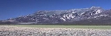
The Egan Range is a line of mountains in White Pine County
, in eastern Nevada
in the western United States
. From Egan Creek near the historic community of Cherry Creek
, the range runs south for approximately 108 miles (173 km), extending into the northern part of Lincoln County
. To the east are the large Steptoe Valley
and the even longer Schell Creek Range
. To the west are the White River Valley
and the scenic White Pine Range
. To the north is the Cherry Creek Range
, while to the south is remote Cave Valley and the southern tip of the Schell Creek Range.
The southern section of the range rises steadily, climbing to the high ridge of Ward Mountain. This crest is over 3 miles (5 km) long and, at elevations up to 10,936 feet (3333 m), includes the highest point of the range. The mountains then descend rapidly to the north, dropping to elevations below 6200 feet near the community of Ely
.
North of Ely the Egan Range rises again at Heusser Mountain (9,411 ft, 2,868 m), approximately 5 miles west of the community of McGill
. This northern group of mountains (which might be considered as a separate range) continues to Telegraph Peak (9918 ft, 3023 m), and then descends to Egan Creek, almost merging with the Cherry Creek Range
.
White Pine County, Nevada
White Pine County is a county located in the U.S. state of Nevada. Its population at the 2010 census was 10,030. Its county seat is Ely. It is the home of Great Basin National Park...
, in eastern Nevada
Nevada
Nevada is a state in the western, mountain west, and southwestern regions of the United States. With an area of and a population of about 2.7 million, it is the 7th-largest and 35th-most populous state. Over two-thirds of Nevada's people live in the Las Vegas metropolitan area, which contains its...
in the western United States
United States
The United States of America is a federal constitutional republic comprising fifty states and a federal district...
. From Egan Creek near the historic community of Cherry Creek
Cherry Creek, Nevada
Cherry Creek is a historic community located in northern White Pine County, in northeastern Nevada in the western United States. It is a census county division , with a population at the 2010 census of 72....
, the range runs south for approximately 108 miles (173 km), extending into the northern part of Lincoln County
Lincoln County, Nevada
Lincoln County is a county located in the U.S. state of Nevada. As of the 2000 census, the population was 4,165. Its county seat is Pioche.-History:...
. To the east are the large Steptoe Valley
Steptoe Valley
The Steptoe Valley is a long basin located in White Pine County, in northeastern Nevada in the western United States. From the historic community of Currie, the valley runs south for approximately 100 miles . To the west are the high Egan Range and the Cherry Creek Range, while to the east is the...
and the even longer Schell Creek Range
Schell Creek Range
The Schell Creek Range is a linear mountain range in central White Pine County, in east-central Nevada. Its length is approximately in a north-south direction....
. To the west are the White River Valley
White River (Nevada)
The White River is a small and discontinuous river located in southeastern Nevada notable for several endemic species of fish.-Course:The river begins at the Great Basin Divide in the White Pine Range near Ely, where it is fed by snow melt and springs from Currant Mountain...
and the scenic White Pine Range
White Pine Range
The White Pine Range is a group of mountains in southern White Pine County, in eastern Nevada. The range runs for approximately 51 miles from Beck Pass in the north to Currant Pass in the south. To the west of the range are the Duckwater tribal lands and the northern arm of large Railroad Valley...
. To the north is the Cherry Creek Range
Cherry Creek Range
The Cherry Creek Range is a line of mountains, Basin and Range faulted, in northern White Pine and southern Elko Counties, in northeastern Nevada in the western United States. The range runs generally north-south for approximately 50 miles...
, while to the south is remote Cave Valley and the southern tip of the Schell Creek Range.
The southern section of the range rises steadily, climbing to the high ridge of Ward Mountain. This crest is over 3 miles (5 km) long and, at elevations up to 10,936 feet (3333 m), includes the highest point of the range. The mountains then descend rapidly to the north, dropping to elevations below 6200 feet near the community of Ely
Ely, Nevada
Ely is the largest city and county seat of White Pine County, Nevada, United States. Ely was founded as a stagecoach station along the Pony Express and Central Overland Route. Ely's mining boom came later than the other towns along US 50, with the discovery of copper in 1906...
.
North of Ely the Egan Range rises again at Heusser Mountain (9,411 ft, 2,868 m), approximately 5 miles west of the community of McGill
McGill, Nevada
McGill is a census-designated place in White Pine County, Nevada, United States. The population was 1,148 at the 2010 census.-Geography:McGill is located at ....
. This northern group of mountains (which might be considered as a separate range) continues to Telegraph Peak (9918 ft, 3023 m), and then descends to Egan Creek, almost merging with the Cherry Creek Range
Cherry Creek Range
The Cherry Creek Range is a line of mountains, Basin and Range faulted, in northern White Pine and southern Elko Counties, in northeastern Nevada in the western United States. The range runs generally north-south for approximately 50 miles...
.
External links
The Egan Range is a line of mountains in White Pine CountyWhite Pine County, Nevada
White Pine County is a county located in the U.S. state of Nevada. Its population at the 2010 census was 10,030. Its county seat is Ely. It is the home of Great Basin National Park...
, in eastern Nevada
Nevada
Nevada is a state in the western, mountain west, and southwestern regions of the United States. With an area of and a population of about 2.7 million, it is the 7th-largest and 35th-most populous state. Over two-thirds of Nevada's people live in the Las Vegas metropolitan area, which contains its...
in the western United States
United States
The United States of America is a federal constitutional republic comprising fifty states and a federal district...
. From Egan Creek near the historic community of Cherry Creek
Cherry Creek, Nevada
Cherry Creek is a historic community located in northern White Pine County, in northeastern Nevada in the western United States. It is a census county division , with a population at the 2010 census of 72....
, the range runs south for approximately 108 miles (173 km), extending into the northern part of Lincoln County
Lincoln County, Nevada
Lincoln County is a county located in the U.S. state of Nevada. As of the 2000 census, the population was 4,165. Its county seat is Pioche.-History:...
. To the east are the large Steptoe Valley
Steptoe Valley
The Steptoe Valley is a long basin located in White Pine County, in northeastern Nevada in the western United States. From the historic community of Currie, the valley runs south for approximately 100 miles . To the west are the high Egan Range and the Cherry Creek Range, while to the east is the...
and the even longer Schell Creek Range
Schell Creek Range
The Schell Creek Range is a linear mountain range in central White Pine County, in east-central Nevada. Its length is approximately in a north-south direction....
. To the west are the White River Valley
White River (Nevada)
The White River is a small and discontinuous river located in southeastern Nevada notable for several endemic species of fish.-Course:The river begins at the Great Basin Divide in the White Pine Range near Ely, where it is fed by snow melt and springs from Currant Mountain...
and the scenic White Pine Range
White Pine Range
The White Pine Range is a group of mountains in southern White Pine County, in eastern Nevada. The range runs for approximately 51 miles from Beck Pass in the north to Currant Pass in the south. To the west of the range are the Duckwater tribal lands and the northern arm of large Railroad Valley...
. To the north is the Cherry Creek Range
Cherry Creek Range
The Cherry Creek Range is a line of mountains, Basin and Range faulted, in northern White Pine and southern Elko Counties, in northeastern Nevada in the western United States. The range runs generally north-south for approximately 50 miles...
, while to the south is remote Cave Valley and the southern tip of the Schell Creek Range.
The southern section of the range rises steadily, climbing to the high ridge of Ward Mountain. This crest is over 3 miles (5 km) long and, at elevations up to 10,936 feet (3333 m), includes the highest point of the range. The mountains then descend rapidly to the north, dropping to elevations below 6200 feet near the community of Ely
Ely, Nevada
Ely is the largest city and county seat of White Pine County, Nevada, United States. Ely was founded as a stagecoach station along the Pony Express and Central Overland Route. Ely's mining boom came later than the other towns along US 50, with the discovery of copper in 1906...
.
North of Ely the Egan Range rises again at Heusser Mountain (9,411 ft, 2,868 m), approximately 5 miles west of the community of McGill
McGill, Nevada
McGill is a census-designated place in White Pine County, Nevada, United States. The population was 1,148 at the 2010 census.-Geography:McGill is located at ....
. This northern group of mountains (which might be considered as a separate range) continues to Telegraph Peak (9918 ft, 3023 m), and then descends to Egan Creek, almost merging with the Cherry Creek Range
Cherry Creek Range
The Cherry Creek Range is a line of mountains, Basin and Range faulted, in northern White Pine and southern Elko Counties, in northeastern Nevada in the western United States. The range runs generally north-south for approximately 50 miles...
.