
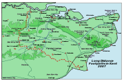
Saxon Shore Way
Encyclopedia
Gravesend, Kent
Gravesend is a town in northwest Kent, England, on the south bank of the Thames, opposite Tilbury in Essex. It is the administrative town of the Borough of Gravesham and, because of its geographical position, has always had an important role to play in the history and communications of this part of...
, Kent
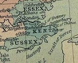
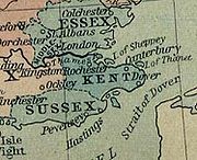
Kent
Kent is a county in southeast England, and is one of the home counties. It borders East Sussex, Surrey and Greater London and has a defined boundary with Essex in the middle of the Thames Estuary. The ceremonial county boundaries of Kent include the shire county of Kent and the unitary borough of...
and traces the coast
Coast
A coastline or seashore is the area where land meets the sea or ocean. A precise line that can be called a coastline cannot be determined due to the dynamic nature of tides. The term "coastal zone" can be used instead, which is a spatial zone where interaction of the sea and land processes occurs...
as it was in Roman
Roman Empire
The Roman Empire was the post-Republican period of the ancient Roman civilization, characterised by an autocratic form of government and large territorial holdings in Europe and around the Mediterranean....
times (note the changed coastline around Romney Marsh
Romney Marsh
Romney Marsh is a sparsely populated wetland area in the counties of Kent and East Sussex in the south-east of England. It covers about 100 mi ² .-Quotations:*“As Egypt was the gift of the Nile, this level tract .....
) as far as Hastings
Hastings
Hastings is a town and borough in the county of East Sussex on the south coast of England. The town is located east of the county town of Lewes and south east of London, and has an estimated population of 86,900....
, East Sussex
East Sussex
East Sussex is a county in South East England. It is bordered by the counties of Kent, Surrey and West Sussex, and to the south by the English Channel.-History:...
, 163 miles (262 km) in total.
History
The line of the Roman fortification that the route traces includes ancient forts, modern towns, nature reserves and coastline: four Roman forts built in the fourth century lie along the route, at ReculverReculver
Reculver is a hamlet and coastal resort situated about east of Herne Bay in southeast England. It is a ward of the City of Canterbury district in the county of Kent. Reculver once occupied a strategic location at the western end of the Wantsum Channel, between the Isle of Thanet and the Kent...
, Richborough
Richborough
Richborough is a settlement north of Sandwich on the east coast of the county of Kent, England. Richborough lies close to the Isle of Thanet....
, Dover
Dover
Dover is a town and major ferry port in the home county of Kent, in South East England. It faces France across the narrowest part of the English Channel, and lies south-east of Canterbury; east of Kent's administrative capital Maidstone; and north-east along the coastline from Dungeness and Hastings...
and Lympne
Lympne
Lympne is a village situated on the former sea cliffs above the Romney Marsh in Kent. It lies approximately west of Folkestone, 2 miles west of Hythe and east of Ashford....
.
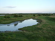
At Seasalter
Seasalter
Seasalter is a village in the Canterbury District of Kent, England. It is located by the sea on the north coast of Kent, between the towns of Whitstable and Faversham, facing the Isle of Sheppey across the estuary of the River Swale...
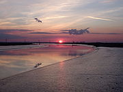
there is an internationally important area for geese ducks and waders. The diversity of scenery along the route includes the wide expanses of marshland bordering the Thames and Medway
River Medway
The River Medway, which is almost entirely in Kent, England, flows for from just inside the West Sussex border to the point where it enters the Thames Estuary....
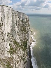
estuaries, the White cliffs of Dover
White cliffs of Dover
The White Cliffs of Dover are cliffs which form part of the British coastline facing the Strait of Dover and France. The cliffs are part of the North Downs formation. The cliff face, which reaches up to , owes its striking façade to its composition of chalk accentuated by streaks of black flint...
, and panoramic views over Romney Marsh
Romney Marsh
Romney Marsh is a sparsely populated wetland area in the counties of Kent and East Sussex in the south-east of England. It covers about 100 mi ² .-Quotations:*“As Egypt was the gift of the Nile, this level tract .....
from the escarpment that marks the ancient coastline between Folkestone
Folkestone
Folkestone is the principal town in the Shepway District of Kent, England. Its original site was in a valley in the sea cliffs and it developed through fishing and its closeness to the Continent as a landing place and trading port. The coming of the railways, the building of a ferry port, and its...
and Rye.
The Saxon Shore Way was originally opened in 1980, but has since been re-established, and in parts re-routed and extended. It follows the coastline of the South East as it was about 1500 years ago, long before the North Kent Marshes or the Romney Marsh came into existence, when the cliff lines to the north and south extended further into the sea and when the Wantsum Channel provided a thoroughfare for boats between the Isle of Thanet
Isle of Thanet
The Isle of Thanet lies at the most easterly point of Kent, England. While in the past it was separated from the mainland by the nearly -wide River Wantsum, it is no longer an island ....
and mainland England. The Way takes its name, The Saxon Shore, from a line of fortifications built along the coastline as it was in the 3rd century AD, towards the end of the Roman period. In this time of crisis Saxon invaders came from the southern regions of modern Denmark and in response the Romans built a line of defensive forts along the coast to repel the newcomers.
Gravesend to Faversham
- GravesendGravesend, KentGravesend is a town in northwest Kent, England, on the south bank of the Thames, opposite Tilbury in Essex. It is the administrative town of the Borough of Gravesham and, because of its geographical position, has always had an important role to play in the history and communications of this part of...
, Town Pier where it shares a start with the WealdwayWealdwayThe Wealdway, Kent and East Sussex, is a public footpath that runs from Gravesend, Kent on the Thames estuary, to the A259 at Eastbourne, 3 km north of Beachy Head....
; HighamHigham, KentHigham is a small village bordering the Hoo Peninsula, in Kent, between Gravesend and Rochester. The civil parish of Higham is in Gravesham district and as at the 2001 UK Census, had a population of 3,938.-History:...
and Cliffe FortCliffe FortCliffe Fort is a Royal Commission fort built in the 1860s on the edge of the Cliffe marshes on the Hoo Peninsula in north Kent to protect against invasion via the Thames. It is opposite Coalhouse Fort in Essex: they are 2 km apart. Construction was difficult due to the marshy ground and the...
; - Cliffe; Hoo PeninsulaHoo PeninsulaThe Hoo Peninsula is a peninsula in England separating the estuaries of the rivers Thames and Medway. It is dominated by a line of sand and clay hills, surrounded by an extensive area of marshland composed of alluvial silt. The name Hoo is the Old English word for spur of land.-History:The Romans...
; StroodStroodStrood is a town in the unitary authority of Medway in South East England. It is part of the ceremonial county of Kent. It lies on the north west bank of the River Medway at its lowest bridging point, and is part of the Rochester post town....
; UpnorUpnorLower Upnor and Upper Upnor are two small villages in Medway, Kent, England. They are in the parish of Frindsbury Extra on the western bank of the River Medway...
; Rochester, where it meets the Medway Valley WalkMedway Valley WalkThe Medway Valley Walk follows the River Medway from Rochester to Tonbridge. Above Allington, it follows the bank of the Medway Navigation. It starts on the Saxon Shore Way at Rochester. The North Downs Way crosses the Medway Valley Walk at the eastern end of the Medway Viaduct or motorway bridge....
; Gillingham; - Lower RainhamRainham, MedwayThe town of Rainham is a part of the Medway Towns conurbation, under the unitary authority of Medway, in South East England, and part of the ceremonial county of Kent. Historically, Rainham was a separate village until, in 1928, it was added to the Municipal Borough of Gillingham, which had itself...
and the Riverside Country ParkRiverside Country ParkRiverside Country Park is a large coastal public park, situated alongside the River Medway estuary between Gillingham and Rainham. The park covers about 100 hectares Riverside Country Park is a large coastal public park, situated alongside the River Medway estuary between Gillingham and Rainham....
; UpchurchUpchurchUpchurch village is situated at the junction of numerous minor roads in the Swale district of Kent, England. It is a civil parish within Swale Borough Council, and the village centre is about 1 mile east of the boundary with the unitary authority of Medway.-History:Upchurch lay on a...
; along the side of The SwaleThe SwaleThe name The Swale refers to the strip of sea separating North Kent from the Isle of Sheppey.- History :The name "Swale" is Old English in origin, and is believed to mean "swirling, rushing river", or "rushing water"....
and the Oare MarshesOare MarshesThe Oare Marshes on the north coast of Kent to the north west of Faversham bordering The Swale. They include an internationally important nature reserve known especially as a site for migratory birds.-Location:...
bird reserve; Faversham.
Faversham
- The Faversham area section is from Conyer Creek in the west alongside The Swale, passing through Harty Ferry; OareOare, KentOare is a village and civil parish north of Faversham in southeast England. It is separated from Faversham by the Oare Creek. To the north of the village are the Oare Marshes, and the Harty Ferry which linked to Harty on the Isle of Sheppey. Kent Wildlife Trust manages a nature reserve that is an...
; Faversham and on to north of GraveneyGraveneyGraveney is a relatively small but widely dispersed village located between Faversham and Whitstable in Kent, England. The main part of the village is located along the intersection of Seasalter Road, Sandbanks Road and Head Hill Road , which is surrounded by farmland...
in the east. The Saxon Shore Way traces the coast as it was in Roman times and follows the line of the Roman fortifications.
Faversham to Deal
- Faversham; Graveney Marshes; SeasalterSeasalterSeasalter is a village in the Canterbury District of Kent, England. It is located by the sea on the north coast of Kent, between the towns of Whitstable and Faversham, facing the Isle of Sheppey across the estuary of the River Swale...
; WhitstableWhitstableWhitstable is a seaside town in Northeast Kent, Southeast England. It is approximately north of the city of Canterbury and approximately west of the seaside town of Herne Bay. It is part of the City of Canterbury district and has a population of about 30,000.Whitstable is famous for its oysters,...
; Herne BayHerne Bay, KentHerne Bay is a seaside town in Kent, South East England, with a population of 35,188. On the south coast of the Thames Estuary, it is north of Canterbury and east of Whitstable. It neighbours the ancient villages of Herne and Reculver and is part of the City of Canterbury local government district...
; ReculverReculverReculver is a hamlet and coastal resort situated about east of Herne Bay in southeast England. It is a ward of the City of Canterbury district in the county of Kent. Reculver once occupied a strategic location at the western end of the Wantsum Channel, between the Isle of Thanet and the Kent...
and the Regulbium Roman Fort where it turns inland, separating from the Thanet Coastal Path; - Marshside where it meets the Wantsum WalkWantsum ChannelThe Wantsum Channel is the name given to a now silted-up watercourse separating the Isle of Thanet and what was the mainland of the English county of Kent...
; UpstreetUpstreetUpstreet is a village in the civil parish of Chislet in Kent, England. It is in the local government district of Canterbury, and the electoral ward of Marshside....
; - Plucks GutterPlucks GutterPlucks Gutter is a small hamlet in Kent, England where the Little Stour and Great Stour rivers meet. During the Middle Ages, the two rivers met the Wantsum Channel at Stourmouth, but the combined rivers now flow onward to the sea via Sandwich to Pegwell Bay near Ramsgate, leaving Plucks Gutter...
meeting the River StourRiver Stour, KentThe River Stour is the river in Kent, England that flows into the English Channel at Pegwell Bay. Above Plucks Gutter, where the Little Stour joins it, the river is normally known as the Great Stour. The upper section of the river, above its confluence with the East Stour at Ashford is sometimes...
and joins the Stour Valley WalkStour Valley WalkThe Stour Valley Walk is a recreational walking route that follows the River Stour, through the Low Weald and Kent Downs, from its source at Lenham to its estuary at Pegwell Bay....
to the Roman FortRutupiaeRichborough Castle contains the ruined remains of a Roman Saxon Shore Fort. It situated in Richborough near Sandwich, Kent.The site has many phases of Roman remains, collectively known as Richborough Fort or Richborough Roman Fort, still visible today and under the care of English Heritage.Rutupiæ ...
at RichboroughRichboroughRichborough is a settlement north of Sandwich on the east coast of the county of Kent, England. Richborough lies close to the Isle of Thanet....
and SandwichSandwich, KentSandwich is a historic town and civil parish on the River Stour in the Non-metropolitan district of Dover, within the ceremonial county of Kent, south-east England. It has a population of 6,800....
, meeting the White Cliffs Country Trail; DealDeal, KentDeal is a town in Kent England. It lies on the English Channel eight miles north-east of Dover and eight miles south of Ramsgate. It is a former fishing, mining and garrison town...
Deal to Dover
- The most picturesque part of the walk is arguable the clifftop stretch between Deal and DoverDoverDover is a town and major ferry port in the home county of Kent, in South East England. It faces France across the narrowest part of the English Channel, and lies south-east of Canterbury; east of Kent's administrative capital Maidstone; and north-east along the coastline from Dungeness and Hastings...
passing South ForelandSouth ForelandSouth Foreland is a chalk headland on the Kent coast of southeast England. It presents a bold cliff to the sea, and commands views over the Strait of Dover. It is northeast of Dover and 15 miles south of North Foreland...
, with a midway break in St Margaret's at Cliffe.
Dover to Rye
- As the walk follows the old coast line it heads inland to LympneLympneLympne is a village situated on the former sea cliffs above the Romney Marsh in Kent. It lies approximately west of Folkestone, 2 miles west of Hythe and east of Ashford....
, AldingtonAldington, KentAldington is a village and civil parish in the Ashford District of Kent, England. The village centre is eight miles south-east of the town of Ashford...
(still part of the Saxon Shore Parish) and Kenardington via HamstreetHamstreetHamstreet is a village in Kent, in South East England.The village is located some 6 miles south of Ashford on the A2070, the main road between Ashford and Hastings...
woods nature reserveNature reserveA nature reserve is a protected area of importance for wildlife, flora, fauna or features of geological or other special interest, which is reserved and managed for conservation and to provide special opportunities for study or research...
before heading for RyeRye, East SussexRye is a small town in East Sussex, England, which stands approximately two miles from the open sea and is at the confluence of three rivers: the Rother, the Tillingham and the Brede...
.
Rye to Hastings
- The walk leaves Rye, following the Royal Military CanalRoyal Military CanalThe Royal Military Canal is a canal running for 28 miles between Seabrook near Folkestone and Cliff End near Hastings, following the old cliff line bordering Romney Marsh.-Construction:...
as far as WinchelseaWinchelseaWinchelsea is a small village in East Sussex, England, located between the High Weald and the Romney Marsh, approximately two miles south west of Rye and seven miles north east of Hastings...
and then on to Hastings.