

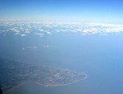
Isle of Thanet
Encyclopedia
Kent
Kent is a county in southeast England, and is one of the home counties. It borders East Sussex, Surrey and Greater London and has a defined boundary with Essex in the middle of the Thames Estuary. The ceremonial county boundaries of Kent include the shire county of Kent and the unitary borough of...
, England. While in the past it was separated from the mainland by the nearly 2000 feet (609.6 m)-wide River Wantsum
River Wantsum
The River Wantsum is a tributary of the River Stour, in Kent, England. Formerly, the River Wantsum and the River Stour together formed the Wantsum Channel, which separated the Isle of Thanet from the mainland of Kent...
, it is no longer an island (see below).
Archaeological remains testify to the fact that ancient peoples lived here. Today, it is a tourist destination, but it also has a busy agricultural base. The Port of Ramsgate serves the Continent.
Etymology
The name seems to be CelticBrythonic languages
The Brythonic or Brittonic languages form one of the two branches of the Insular Celtic language family, the other being Goidelic. The name Brythonic was derived by Welsh Celticist John Rhys from the Welsh word Brython, meaning an indigenous Briton as opposed to an Anglo-Saxon or Gael...
in origin, coming from the Welsh-like phrase tan-arth or teine-arth meaning "high fire", with the possibility of it being a place where beacons were set. Ptolemy calls it Tolianis, the Romans Tanatus and Bede
Bede
Bede , also referred to as Saint Bede or the Venerable Bede , was a monk at the Northumbrian monastery of Saint Peter at Monkwearmouth, today part of Sunderland, England, and of its companion monastery, Saint Paul's, in modern Jarrow , both in the Kingdom of Northumbria...
referred to it as Tanatos insula. The name 'Tenet' was listed in the Domesday Book
Domesday Book
Domesday Book , now held at The National Archives, Kew, Richmond upon Thames in South West London, is the record of the great survey of much of England and parts of Wales completed in 1086...
of 1086, whereas an 18th century classical dictionary lists Tane'tus, a small island of Albion.
St. Isidore of Seville's etymology is, if doubtful, certainly colorful: "Thanet is an island in the Ocean in the Gallic channel (English channel), separated from Britannia by a narrow estuary, with fruitful fields and rich soil. It is name Thanet (tanatos) from the death of serpents. Although the island itself is unacquainted with serpents, if soil from it is carried away and brought to any other nation, it kills snakes there."
History
Archaeological evidence shows that the area now known as the Isle of Thanet was one of the major areas of Stone AgeStone Age
The Stone Age is a broad prehistoric period, lasting about 2.5 million years , during which humans and their predecessor species in the genus Homo, as well as the earlier partly contemporary genera Australopithecus and Paranthropus, widely used exclusively stone as their hard material in the...
settlement. A large hoard of Bronze Age
Bronze Age
The Bronze Age is a period characterized by the use of copper and its alloy bronze as the chief hard materials in the manufacture of some implements and weapons. Chronologically, it stands between the Stone Age and Iron Age...
implements have been found at Minster-in-Thanet
Minster-in-Thanet
Minster-in-Thanet, also known as Minster, is a village and civil parish in the Thanet District of Kent, England. The village is situated to the west of Ramsgate and to the north east of Canterbury; it lies just south west of Kent International Airport and just north of the River Stour...
; and several Iron Age
Iron Age
The Iron Age is the archaeological period generally occurring after the Bronze Age, marked by the prevalent use of iron. The early period of the age is characterized by the widespread use of iron or steel. The adoption of such material coincided with other changes in society, including differing...
settlements have also come to light.
Julius Caesar
Gaius Julius Caesar was a Roman general and statesman and a distinguished writer of Latin prose. He played a critical role in the gradual transformation of the Roman Republic into the Roman Empire....
came first, briefly, in both 55 and 54 BC; one hundred years later Claudius
Claudius
Claudius , was Roman Emperor from 41 to 54. A member of the Julio-Claudian dynasty, he was the son of Drusus and Antonia Minor. He was born at Lugdunum in Gaul and was the first Roman Emperor to be born outside Italy...
sent four legions to Britain, where the Romans were to remain for the next four hundred years. During that time the port of Richborough
Richborough
Richborough is a settlement north of Sandwich on the east coast of the county of Kent, England. Richborough lies close to the Isle of Thanet....
, on the opposite side of the Wantsum Channel
River Wantsum
The River Wantsum is a tributary of the River Stour, in Kent, England. Formerly, the River Wantsum and the River Stour together formed the Wantsum Channel, which separated the Isle of Thanet from the mainland of Kent...
(see Geography below), became one of the chief ports. After the breakup of the Roman Empire and their departure from Britain, other invaders soon followed.
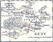
Vortigern
Vortigern
Vortigern , also spelled Vortiger and Vortigen, was a 5th-century warlord in Britain, a leading ruler among the Britons. His existence is considered likely, though information about him is shrouded in legend. He is said to have invited the Saxons to settle in Kent as mercenaries to aid him in...
, King of the Britons
Britons (historical)
The Britons were the Celtic people culturally dominating Great Britain from the Iron Age through the Early Middle Ages. They spoke the Insular Celtic language known as British or Brythonic...
, was under attack from other tribes and called for assistance. Among them were the Jutes
Jutes
The Jutes, Iuti, or Iutæ were a Germanic people who, according to Bede, were one of the three most powerful Germanic peoples of their time, the other two being the Saxons and the Angles...
Hengest
Hengest
Hengist and Horsa are figures of Anglo-Saxon, and subsequently British, legend, which records the two as the Germanic brothers who led the Angle, Saxon, and Jutish armies that conquered the first territories of Great Britain in the 5th century AD...
and Horsa; he is said to have rewarded the Isle of Thanet in return for their services. As the following extract from the Historia Britonum
Historia Britonum
The Historia Brittonum, or The History of the Britons, is a historical work that was first composed around 830, and exists in several recensions of varying difference. It purports to relate the history of the Brittonic inhabitants of Britain from earliest times, and this text has been used to write...
(first written sometime shortly after AD 833) testifies:
Throughout this time the Isle remained an island. The Wantsum Channel allowed ships to sail between the mainland and the island in calm waters. Gradually this silted up, and the last ship sailed through the Channel in 1672.
In 597 Augustine of Canterbury
Augustine of Canterbury
Augustine of Canterbury was a Benedictine monk who became the first Archbishop of Canterbury in the year 597...
is said, by the Venerable Bede
Bede
Bede , also referred to as Saint Bede or the Venerable Bede , was a monk at the Northumbrian monastery of Saint Peter at Monkwearmouth, today part of Sunderland, England, and of its companion monastery, Saint Paul's, in modern Jarrow , both in the Kingdom of Northumbria...
, to have landed with 40 men at Ebbsfleet, in the parish of Minster-in-Thanet, before founding Britain's second Christian
Christianity
Christianity is a monotheistic religion based on the life and teachings of Jesus as presented in canonical gospels and other New Testament writings...
monastery in Canterbury
Canterbury
Canterbury is a historic English cathedral city, which lies at the heart of the City of Canterbury, a district of Kent in South East England. It lies on the River Stour....
(the first was founded fifty years earlier by Saint Columba
Columba
Saint Columba —also known as Colum Cille , Colm Cille , Calum Cille and Kolban or Kolbjørn —was a Gaelic Irish missionary monk who propagated Christianity among the Picts during the Early Medieval Period...
on Eilean na Naoimh, in the Hebrides): a cross marks the spot. In 851 and again in 854, the Vikings wintered on Thanet.
Minster's village website states "It is widely believed, around 670 AD, whether in truth or legend, that the Hind emblem owes its origin to Egbert, King of Kent and Princess Domneva. The King purportedly asked Domneva which piece of land she wished to take as compensation for the murder of her two brothers. Her answer was that she would take no more than her hind would run around. This the King granted her with pleasure, and the land became the new Minster."
By 1334–1335 Thanet had the highest population density in Kent according to Edward III's lay subsidy roll
Subsidy roll
Subsidy Rolls are records of taxation in England made between the 12th and 17th centuries. They are often valuable sources of historical information....
s. It acted as a granary for Calais and documents towards the end of that century refer to turreted walls beneath the cliffs needing maintenance. Coastal erosion has long since destroyed these structures.
Governance
Margate was incorporated as a municipal boroughMunicipal borough
Municipal boroughs were a type of local government district which existed in England and Wales between 1835 and 1974, in Northern Ireland from 1840 to 1973 and in the Republic of Ireland from 1840 to 2002...
in 1857 and Ramsgate in 1884. Broadstairs and St Peter's Urban District and Isle of Thanet Rural District
Isle of Thanet Rural District
The Isle of Thanet Rural District was a rural district covering part of the Isle of Thanet in the county of Kent, England, from 1894 to 1935. Most of its former area is now part of the Thanet district....
covered the rest of the island from 1894. Since 1974, the Isle of Thanet forms the major part of the Thanet
Thanet
Thanet is a local government district of Kent, England which was formed under the Local Government Act 1972, and came into being on 1 April 1974...
local government district of Kent.
Geography
The Isle of Thanet first came into being when sea levels rose after the last Ice AgeIce age
An ice age or, more precisely, glacial age, is a generic geological period of long-term reduction in the temperature of the Earth's surface and atmosphere, resulting in the presence or expansion of continental ice sheets, polar ice sheets and alpine glaciers...
, around 5000 BC. The North Sea
North Sea
In the southwest, beyond the Straits of Dover, the North Sea becomes the English Channel connecting to the Atlantic Ocean. In the east, it connects to the Baltic Sea via the Skagerrak and Kattegat, narrow straits that separate Denmark from Norway and Sweden respectively...
encroached on the land which is now the estuary of the River Thames
River Thames
The River Thames flows through southern England. It is the longest river entirely in England and the second longest in the United Kingdom. While it is best known because its lower reaches flow through central London, the river flows alongside several other towns and cities, including Oxford,...
, and southwards to reach the higher land of the North Downs
North Downs
The North Downs are a ridge of chalk hills in south east England that stretch from Farnham in Surrey to the White Cliffs of Dover in Kent. The North Downs lie within two Areas of Outstanding Natural Beauty , the Surrey Hills and the Kent Downs...
, leaving behind an island composed of Upper Chalk
Chalk Formation
The Chalk Group is a lithostratigraphic unit in the northwestern part of Europe. It is characterised by thick deposits of chalk, a soft porous white limestone, deposited in a marine environment during the Upper Cretaceous period.Chalk is a limestone that consists of coccolith biomicrite...
in its wake. Eventually the sea broke through river valleys in the North Downs to the south (Middle Chalk) and finally today's English Channel
English Channel
The English Channel , often referred to simply as the Channel, is an arm of the Atlantic Ocean that separates southern England from northern France, and joins the North Sea to the Atlantic. It is about long and varies in width from at its widest to in the Strait of Dover...
was opened up. The Upper Chalk is a soft pure-white limestone with abundant flints. The proto-River Stour
River Stour, Kent
The River Stour is the river in Kent, England that flows into the English Channel at Pegwell Bay. Above Plucks Gutter, where the Little Stour joins it, the river is normally known as the Great Stour. The upper section of the river, above its confluence with the East Stour at Ashford is sometimes...
then formed part of the intervening water, with a new tributary, the River Wantsum
River Wantsum
The River Wantsum is a tributary of the River Stour, in Kent, England. Formerly, the River Wantsum and the River Stour together formed the Wantsum Channel, which separated the Isle of Thanet from the mainland of Kent...
, completing it; it became known as the Wantsum Channel.
The Wantsum Channel gradually narrowed as pebble beaches built up at the southern end of the strait, blocking silt coming down down the Stour. In the eighth century it was reported that the Channel was now three furlong
Furlong
A furlong is a measure of distance in imperial units and U.S. customary units equal to one-eighth of a mile, equivalent to 220 yards, 660 feet, 40 rods, or 10 chains. The exact value of the furlong varies slightly among English-speaking countries....
s wide (660 yards (603.5 m)), and a map of 1414 showed a ferry crossing at Sarre
Sarre, Kent
Sarre is a village and civil parish in Thanet District in Kent, England. The village is a part of St. Nicholas-at-Wade ecclesiastical parish, after having lost the local church of St. Giles in Elizabethan times; the ecclesiastical parishes were subsequently combined. In its own right Sarre is an...
. The first bridge over the channel was built there in 1485. Until the mid 18th century there was a ferry between Sandwich
Sandwich, Kent
Sandwich is a historic town and civil parish on the River Stour in the Non-metropolitan district of Dover, within the ceremonial county of Kent, south-east England. It has a population of 6,800....
and the island; a wooden drawbridge was built, and the ferry was closed.
Today the Isle is an island no longer and the erstwhile channel is now flat marshland criss-crossed by drainage ditches. Meanwhile the exposed chalk cliffs are gradually being worn down by the sea, particularly at the North Foreland
North Foreland
North Foreland is a chalk headland on the Kent coast of southeast England.North Foreland forms the eastern end of the Isle of Thanet. It presents a bold cliff to the sea, and commands views over the southern North Sea.-Lighthouse:...
. Much else of the coast is a built-up area. The Wantsum area is still liable to flooding: during the North Sea flood of 1953
North Sea flood of 1953
The 1953 North Sea flood was a major flood caused by a heavy storm, that occurred on the night of Saturday 31 January 1953 and morning of 1 February 1953. The floods struck the Netherlands, Belgium, England and Scotland.A combination of a high spring tide and a severe European windstorm caused a...
Thanet was cut off for a few days, but the sea defences have been strengthened since then.
The soil and equable climate of the Isle have always encouraged arable farming.
Today there are still farms inland, but the coast is nearly all covered in settlements, most of which have come into being in the 19th and 20th centuries.
As the popularity of the seaside resort
Seaside resort
A seaside resort is a resort, or resort town, located on the coast. Where a beach is the primary focus for tourists, it may be called a beach resort.- Overview :...
grew, so did that of the Isle of Thanet. At first the holidaymakers came by boat from London; after the coming of the railways in the mid 1840s, that became the preferred mode of transport. The population grew, as the following population statistics show:
| |
|
|
|---|---|---|
| Ramsgate Ramsgate is a seaside town in the district of Thanet in east Kent, England. It was one of the great English seaside towns of the 19th century and is a member of the ancient confederation of Cinque Ports. It has a population of around 40,000. Ramsgate's main attraction is its coastline and its main... & St Lawrence |
|
|
| Margate -Demography:As of the 2001 UK census, Margate had a population of 40,386.The ethnicity of the town was 97.1% white, 1.0% mixed race, 0.5% black, 0.8% Asian, 0.6% Chinese or other ethnicity.... |
|
|
| Broadstairs Broadstairs is a coastal town on the Isle of Thanet in the Thanet district of east Kent, England, about south-east of London. It is part of the civil parish of Broadstairs and St Peter's, which includes St. Peter's and had a population in 2001 of about 24,000. Situated between Margate and... & St Peter's |
|
|
Landmarks
The principal landmarks on the Isle are the North Foreland, and all the bays around the coastline, the principal ones of which are Minnis Bay, Palm Bay, Botany BayBotany Bay, Kent
Botany Bay is a bay in Broadstairs, Kent on the south east coast of England.Botany Bay is the northern most of seven bays in Broadstairs. It features chalk cliffs and is a popular tourist location...
, Joss Bay
Broadstairs
Broadstairs is a coastal town on the Isle of Thanet in the Thanet district of east Kent, England, about south-east of London. It is part of the civil parish of Broadstairs and St Peter's, which includes St. Peter's and had a population in 2001 of about 24,000. Situated between Margate and...
, and Pegwell Bay
Pegwell Bay
Pegwell Bay is a shallow inlet in the English Channel coast at the estuary of the River Stour between Ramsgate and Sandwich in Kent. Situated in the bay is a large nature reserve, known for its migrating waders and wildfowl, with a complete series of seashore habitats including extensive mudflats...
: the latter being part of the estuary of the River Stour. In 2007, seven of those beaches met stringent quality standards and were awarded a Blue flag
Blue Flag beach
The Blue Flag is a certification by the Foundation for Environmental Education that a beach or marina meets its stringent standards.The Blue Flag is a trademark owned by FEE which is a not-for-profit, non-governmental organisation consisting of 65 organisations in 60 member countries in Europe,...
: Minnis Bay, Botany Bay (Broadstairs), Margate Main Sands, St Mildreds Bay (Westgate), Stone Bay (Broadstairs), West Bay (Westgate), and Westbrook Bay. In 2008, this had risen to 10 beaches.
Transport
The rail connections are via the Chatham Main LineChatham Main Line
The Chatham Main Line is a British railway line that runs from either London Victoria to Dover Priory / Ramsgate or London St Pancras to Faversham, with both services travelling via Medway...
through Margate to Ramsgate, and the Ashford to Ramsgate (via Canterbury West) line
Ashford to Ramsgate (via Canterbury West) line
The Ashford to Ramsgate line is the railway that runs from Ashford to Ramsgate via Canterbury West. The same termini can be reached by the Kent Coast LineThe line is electrified .-Services:...
. New high speed rail links from London to Thanet began in December 2009, and form part of the UK's first true high-speed commuter service, according to the South Eastern Railway Company. Main road links are the A28
A28 road
The A28 is a trunk road in southern England. It runs south-west from the seaside resort of Margate in Kent via Westgate and Birchington, reaching open countryside at Sarre. The road continues via Upstreet and Hersden to Sturry, and on to the cathedral city of Canterbury...
which brings traffic from Canterbury and Ashford; and the A299
A299 road
The A299, better known as the Thanet Way, is a major road in the county of Kent, England, and runs from Brenley Corner near Faversham to Ramsgate via Whitstable and Herne Bay. It is predominantly used for freight traffic to Ramsgate Harbour and local traffic to Thanet.Most of the A299 was...
, north coast route. The Thanet Coastal Path skirts the coast.
There is an airport at Manston
Manston, Kent
Manston is a village and civil parish in the Thanet district of Kent, England. The village is situated one mile north-west of Ramsgate. The parish includes four hamlets and Kent International Airport.-Etymology:...
, formerly RAF Manston
RAF Manston
RAF Manston was an RAF station in the north-east of Kent, at on the Isle of Thanet from 1916 until 1996. The site is now split between a commercial airport Kent International Airport and a continuing military use by the Defence Fire Training and Development Centre , following on from a long...
, but since renamed by its commercial operators as Kent International Airport
Kent International Airport
Manston - Kent's International Airport is an airport located at Manston in the District of Thanet within Kent, England, northeast of Canterbury. It was formerly called RAF Manston , and was also known as London Manston Airport...
. Because it was used as an U.S. airbase during the second world war, it has one of the longest runways in the UK, and is designated by the United Nations as an emergency landing site for aircraft in trouble.
Ferry services (predominantly freight and car with passengers) are operated by Transeuropa ferries
Transeuropa Ferries
TransEuropa Ferries operates a ferry service between Ramsgate, Kent, UK and Ostend, West Flanders, Belgium. TransEuropa Ferries n.v. is the cross channel satellite arm of TransEuropa Shipping Lines d.o.o. of Slovenia....
to the Continent from Port of Ramsgate.