
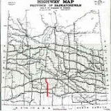
Saskatchewan Highway 58
Encyclopedia
Highway 58 is an oiled surface highway
in the Canadian
province of Saskatchewan
which handles approximately 100 vehicles per day. It runs from Highway 18
3 kilometers west of Fir Mountain until Highway 1
/Highway 19
near Chaplin
in the South-Central area of the province. Highway 58 is about 132 kilometers (82 mi.) long traversing through the Missouri Coteau. There is one multiplex of 5 kilometers with Saskatchewan Highway 363
.
The highway's passage through the province offers a diverse sample of Saskatchewan to a traveler, taking in rural villages and towns, the scenery of the Missouri Coteau, Thomson Lake which is a man made lake for recreational and reservoir purposes, natural lakes such as Chaplin Lake which is the second largest saline lake in Canada
. The terrain of the Missouri Coteau features low hummocky, undulating, rolling hills, potholes, and grasslands. This physiographic region of Saskatchewan is the uplands Missouri Coteau, a part of the Great Plains Province or Alberta Plateau Region which extends across the south east corner of the province of Saskatchewan. Highway 58 runs through the first regional park of Saskatchewan; Thomson Lake Regional Park, and also provides nearby access to Shamrock Regional Park another early regional park of Saskatchewan. The Louis Pierre Gravel National Historic Marker commemorates history at the north end of Highway 58, and the Cripple Creek Provincial Historic Marker is located at the south end. Highway 58 also penetrates into the heart of south central Saskatchewan to access the Chaplin/Old Wives/ Reed Lakes Complex, a shorebird sanctuary of international repute and fame.

Wood Mountain First Nations Reserve is located near Fir Mountain and is south of the southern terminus of Highway 58. Historically Sioux Indians traversed this area as they followed Sitting Bull
.
37.2 kilometers north is Lafleche, Saskatchewan
first called Buffalo Head. Lafleche is located near Thomson Lake and became a town in 1953. The CPR
line came through, in 1913. Mail delivery arrived via train, however this switched to mail truck in 1958. Traveling a distance of 57.8 kilometers is the town of Gravelbourg
which is noted for being the Cultural Gem of Saskatchewan. Gravelbourg features the Our Lady of Assumption Roman Catholic Co-Cathedral and at one time was a bustling agricultural centre and hosted nine agricultural elevators.
Shamrock Regional Park is south east of Shamrock, Saskatchewan. 98.5 kilometers from the southern terminus is the village of Shamrock. Traveling 135 kilometers to the northern terminus of Highway 58 is Chaplin
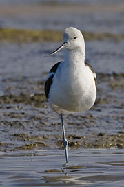
. A major attraction for bird watchers is the Chaplin Shorebird Site. Approaching this town, there is a large American Avocet statue beside the road in tribute to the many bird watching sanctuaries. Chaplin is home to diverse industry such as a shrimp processing plant, sodium sulphate mining and pulse and oilseed agriculture.
were created to provide a civic government to rural residents, such as police, health, and fire protection, education, as well as bridge and road maintenance and construction. The early roads in Saskatchewan began as dirt roads along the township and range roads surveyed by the Dominion Government land surveyors around homestead allotments. 2 and 4 horse teams would plow and grade these roads before graders and scrapers were bought by the various rural municipalities. The RM would also hire crews to maintain the road ditches, and keep the roads clear of snow during the winter months. Joint funding with the provincial government and RMs provided oil surfacing and ashpalt highway surfaces.
Waverley RM
was honored to have Boyd Anderson as their Rural Municipality reeve for 27 years. He has been honoured with a number of awards among them are the Northern International Livestock Hall of Fame, Saskatchewan Agricultural Hall of Fame, honorary doctor of laws degree and Centennial Medal. Waverly RM serves 422 rural residents (2006 census) since its incorporation on February 1, 1913. within an area of 1,429.30 kilometers squared.
Wood River RM
was incorporated December 9, 1912. This RM provides essential services to 387 rural residents (2006 census) within its area of 838.45 kilometers squared.
Gravelbourg RM
in 1928 was the most populated Rural Municipality
in Saskatchewan
. In 2006 this RM served 329 rural residents within 842.08 kilometers squared. Gravelbourg RM was established December 9, 1912.
Shamrock RM
was created August 26, 1912 and encompasses two rural villages, Shamrock on the highway as well as Kelstern which is nearby. The main economic activity is livestock and crop production. Shamrock RM serves 226 rural residents(2006 census) within its boundaries contained in an area of 757.52 kilometers squared.
Chaplin RM
covers a total area of 802.74 kilometers squared and a population of 138 as of 2006 and was incorporated on January 1, 1913. The Rural Municipality
serves the rural community with various infrastructure requirements.
National Historic Site, Louis Pierre Gravel honours the arrival of the abbot Louis-Pierre Gravel, a missionary-colonizer and the Franco-Americans who settled Gravelbourg. The memorial site is located south of Highway 43
and just east of Highway 58.
Thomson Lake Regional Park a man made lake along Highway 58 near Lafleche, Saskatchewan
is 81 hectares (200 acres) in size and hosts swimming lessons, camping, picnicking, boating and golf. Thomson Lake was created in 1958 by Dr Thomson as a reservoir for Lafleche
and Gravelbourg
creating water resources in the dry desert like area historically known as the Palliser Triangle. Thomson Lake local regional park became the first regional park in the province of Saskatchewan.
Notukeu Creek is traversed by Highway 58.
Shamrock Regional Park is 55 acres (222,577.3 m²) in size and features camping, a playground, and baseball diamonds on the Wood River.
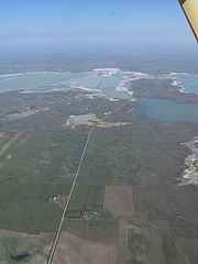
Chaplin Lake is a saline lake which has an area of 52 kilometers squared (20 mi2), making it the second largest saline lake in Canada. is a haven for many varieties of shorebirds. The Chaplin, Old Wives and Reed Lake complex is a site in the Western Hemisphere Shorebird Reserve Network
, and was dedicated as having global importance in May, 1997. This was followed by recognition as a globally significant Important Bird Area
in 1999. The endangered species of Piping plover
s find sanctuary here as well. Saskatchewan Heritage Marsh is located at the south end of Chaplin Lake where Sanderling
, Stilt Sandpiper
, American Avocet
, Semipalmated
and Baird's Sandpiper
, Killdeer
, Long-billed Curlew
, Marbled Godwit
, and Dowitcher
can be often seen in the spring.
Provincial Historic Site Cripple Creek provincial historic marker is located at the junction of Highway 13
and Highway 58. Cripple Creek Crossing - North West Mounted Police Camp Site is a municipal heritage site. This area encompasses 128 hectares and commemorates the history of the "March West" of the Royal Canadian Mounted Police
under the command of George Arthur French on July 8, 1874.
Highway
A highway is any public road. In American English, the term is common and almost always designates major roads. In British English, the term designates any road open to the public. Any interconnected set of highways can be variously referred to as a "highway system", a "highway network", or a...
in the Canadian
Canada
Canada is a North American country consisting of ten provinces and three territories. Located in the northern part of the continent, it extends from the Atlantic Ocean in the east to the Pacific Ocean in the west, and northward into the Arctic Ocean...
province of Saskatchewan
Saskatchewan
Saskatchewan is a prairie province in Canada, which has an area of . Saskatchewan is bordered on the west by Alberta, on the north by the Northwest Territories, on the east by Manitoba, and on the south by the U.S. states of Montana and North Dakota....
which handles approximately 100 vehicles per day. It runs from Highway 18
Saskatchewan Highway 18
Highway 18 is a highway in the Canadian province of Saskatchewan. It runs from Highway 13 near Robsart to the Manitoba border near Gainsborough, where it becomes Highway 3. Highway 18 is about 714 km long.-Communities along the route:...
3 kilometers west of Fir Mountain until Highway 1
Saskatchewan Highway 1
Highway 1 is the Saskatchewan section of the Trans-Canada Highway mainland route. The total distance of the Trans-Canada Highway in Saskatchewan is . The highway traverses Saskatchewan from the western border with Alberta, from Highway 1, to Manitoba where it continues as Highway 1, PTH 1. The...
/Highway 19
Saskatchewan Highway 19
Highway 19 is a highway in the Canadian province of Saskatchewan connecting Highway 15 northern extremity near Hawarden to Highway 18 at the southern extremity near Mankota....
near Chaplin
Chaplin, Saskatchewan
Chaplin is a rural village in Saskatchewan, Canada situated on the Trans-Canada Highway approximately 85 km from Moose Jaw and 90 km from Swift Current. The main industries of Chaplin are Saskatchewan Minerals and farming/ ranching. Chaplin consists of eight streets, two crescents, and...
in the South-Central area of the province. Highway 58 is about 132 kilometers (82 mi.) long traversing through the Missouri Coteau. There is one multiplex of 5 kilometers with Saskatchewan Highway 363
Saskatchewan Highway 363
Highway 363 is a highway in the Canadian province of Saskatchewan. It runs from Highway 4 to Highway 2 in Moose Jaw. Highway 363 is about 203 km long....
.
The highway's passage through the province offers a diverse sample of Saskatchewan to a traveler, taking in rural villages and towns, the scenery of the Missouri Coteau, Thomson Lake which is a man made lake for recreational and reservoir purposes, natural lakes such as Chaplin Lake which is the second largest saline lake in Canada
Canada
Canada is a North American country consisting of ten provinces and three territories. Located in the northern part of the continent, it extends from the Atlantic Ocean in the east to the Pacific Ocean in the west, and northward into the Arctic Ocean...
. The terrain of the Missouri Coteau features low hummocky, undulating, rolling hills, potholes, and grasslands. This physiographic region of Saskatchewan is the uplands Missouri Coteau, a part of the Great Plains Province or Alberta Plateau Region which extends across the south east corner of the province of Saskatchewan. Highway 58 runs through the first regional park of Saskatchewan; Thomson Lake Regional Park, and also provides nearby access to Shamrock Regional Park another early regional park of Saskatchewan. The Louis Pierre Gravel National Historic Marker commemorates history at the north end of Highway 58, and the Cripple Creek Provincial Historic Marker is located at the south end. Highway 58 also penetrates into the heart of south central Saskatchewan to access the Chaplin/Old Wives/ Reed Lakes Complex, a shorebird sanctuary of international repute and fame.
Communities
| Communities |
|---|
|
Wood Mountain First Nations Reserve is located near Fir Mountain and is south of the southern terminus of Highway 58. Historically Sioux Indians traversed this area as they followed Sitting Bull
Sitting Bull
Sitting Bull Sitting Bull Sitting Bull (Lakota: Tȟatȟáŋka Íyotake (in Standard Lakota Orthography), also nicknamed Slon-he or "Slow"; (c. 1831 – December 15, 1890) was a Hunkpapa Lakota Sioux holy man who led his people as a tribal chief during years of resistance to United States government policies...
.
37.2 kilometers north is Lafleche, Saskatchewan
Lafleche, Saskatchewan
Lafleche is a small community in southwest Saskatchewan, Canada. As of 2006, the population of Lafleche is 370.-Community profile:In 1913 the Canadian Pacific Railway came to Lafleche. In 1937 after eight consecutive crop failures, the once prosperous Lafleche district was near rock bottom...
first called Buffalo Head. Lafleche is located near Thomson Lake and became a town in 1953. The CPR
Canadian Pacific Railway
The Canadian Pacific Railway , formerly also known as CP Rail between 1968 and 1996, is a historic Canadian Class I railway founded in 1881 and now operated by Canadian Pacific Railway Limited, which began operations as legal owner in a corporate restructuring in 2001...
line came through, in 1913. Mail delivery arrived via train, however this switched to mail truck in 1958. Traveling a distance of 57.8 kilometers is the town of Gravelbourg
Gravelbourg, Saskatchewan
-Education:The town has for the past four decades been noteworthy for College Mathieu, a francophone boarding school for boys and girls who wish to acquire or retain fluency in French...
which is noted for being the Cultural Gem of Saskatchewan. Gravelbourg features the Our Lady of Assumption Roman Catholic Co-Cathedral and at one time was a bustling agricultural centre and hosted nine agricultural elevators.
Shamrock Regional Park is south east of Shamrock, Saskatchewan. 98.5 kilometers from the southern terminus is the village of Shamrock. Traveling 135 kilometers to the northern terminus of Highway 58 is Chaplin
Chaplin, Saskatchewan
Chaplin is a rural village in Saskatchewan, Canada situated on the Trans-Canada Highway approximately 85 km from Moose Jaw and 90 km from Swift Current. The main industries of Chaplin are Saskatchewan Minerals and farming/ ranching. Chaplin consists of eight streets, two crescents, and...
. A major attraction for bird watchers is the Chaplin Shorebird Site. Approaching this town, there is a large American Avocet statue beside the road in tribute to the many bird watching sanctuaries. Chaplin is home to diverse industry such as a shrimp processing plant, sodium sulphate mining and pulse and oilseed agriculture.
History
The rural municipalitiesRural municipality
A rural municipality, often abbreviated RM, is a form of municipality in the Canadian provinces of Manitoba and Saskatchewan, perhaps best comparable to counties or townships in the western United States...
were created to provide a civic government to rural residents, such as police, health, and fire protection, education, as well as bridge and road maintenance and construction. The early roads in Saskatchewan began as dirt roads along the township and range roads surveyed by the Dominion Government land surveyors around homestead allotments. 2 and 4 horse teams would plow and grade these roads before graders and scrapers were bought by the various rural municipalities. The RM would also hire crews to maintain the road ditches, and keep the roads clear of snow during the winter months. Joint funding with the provincial government and RMs provided oil surfacing and ashpalt highway surfaces.
Waverley RM
Waverley No. 44, Saskatchewan
This article is about the rural municipality in Canada. For other places with the same name, see Waverley Waverley No. 44 is a rural municipality of 422 rural residents in the southwestern part of Saskatchewan, Canada. The RM was incorporated February 1, 1913. Other urban municipalities in the...
was honored to have Boyd Anderson as their Rural Municipality reeve for 27 years. He has been honoured with a number of awards among them are the Northern International Livestock Hall of Fame, Saskatchewan Agricultural Hall of Fame, honorary doctor of laws degree and Centennial Medal. Waverly RM serves 422 rural residents (2006 census) since its incorporation on February 1, 1913. within an area of 1,429.30 kilometers squared.
Wood River RM
Wood River No. 74, Saskatchewan
This article is about the rural municipality in Canada. For other places with the same name, see Wood River Wood River No. 74 is a rural municipality of 422 rural residents in the southwestern part of Saskatchewan, Canada. The RM was incorporated December 9, 1912...
was incorporated December 9, 1912. This RM provides essential services to 387 rural residents (2006 census) within its area of 838.45 kilometers squared.
Gravelbourg RM
Gravelbourg No. 104, Saskatchewan
This article is about the rural municipality in Canada. For the Saskatchewan town, see Gravelbourg, SaskatchewanGravelbourg No. 104 is a rural municipality of 329 rural residents in the southwestern part of Saskatchewan, Canada. The RM was incorporated December 9, 1912. Whereas, the Local...
in 1928 was the most populated Rural Municipality
Rural municipality
A rural municipality, often abbreviated RM, is a form of municipality in the Canadian provinces of Manitoba and Saskatchewan, perhaps best comparable to counties or townships in the western United States...
in Saskatchewan
Saskatchewan
Saskatchewan is a prairie province in Canada, which has an area of . Saskatchewan is bordered on the west by Alberta, on the north by the Northwest Territories, on the east by Manitoba, and on the south by the U.S. states of Montana and North Dakota....
. In 2006 this RM served 329 rural residents within 842.08 kilometers squared. Gravelbourg RM was established December 9, 1912.
Shamrock RM
Shamrock No. 134, Saskatchewan
Shamrock No. 134 is a rural municipality in the Canadian province of Saskatchewan, located in South-Central Saskatchewan South of the Trans Canada Highway, and includes Kelstern. As of the 2006 Census, the village of Shamrock is a separately governed entity lying within the R.M.'s borders....
was created August 26, 1912 and encompasses two rural villages, Shamrock on the highway as well as Kelstern which is nearby. The main economic activity is livestock and crop production. Shamrock RM serves 226 rural residents(2006 census) within its boundaries contained in an area of 757.52 kilometers squared.
Chaplin RM
Chaplin No. 164, Saskatchewan
-Area statistics:*Lat 50.416765762°*Long -106.584534688*Time zone UTC-6-External links:********- References :...
covers a total area of 802.74 kilometers squared and a population of 138 as of 2006 and was incorporated on January 1, 1913. The Rural Municipality
Rural municipality
A rural municipality, often abbreviated RM, is a form of municipality in the Canadian provinces of Manitoba and Saskatchewan, perhaps best comparable to counties or townships in the western United States...
serves the rural community with various infrastructure requirements.
Attractions
| Major attractions |
|---|
|
National Historic Site, Louis Pierre Gravel honours the arrival of the abbot Louis-Pierre Gravel, a missionary-colonizer and the Franco-Americans who settled Gravelbourg. The memorial site is located south of Highway 43
Saskatchewan Highway 43
Highway 43 is a highway in the Canadian province of Saskatchewan. It runs from Highway 4 until Highway 2. Highway 43 is about 131 km long.-Communities:*Neville, km 10*Pambrun, km 23*Vanguard, km 35...
and just east of Highway 58.
Thomson Lake Regional Park a man made lake along Highway 58 near Lafleche, Saskatchewan
Lafleche, Saskatchewan
Lafleche is a small community in southwest Saskatchewan, Canada. As of 2006, the population of Lafleche is 370.-Community profile:In 1913 the Canadian Pacific Railway came to Lafleche. In 1937 after eight consecutive crop failures, the once prosperous Lafleche district was near rock bottom...
is 81 hectares (200 acres) in size and hosts swimming lessons, camping, picnicking, boating and golf. Thomson Lake was created in 1958 by Dr Thomson as a reservoir for Lafleche
Lafleche, Saskatchewan
Lafleche is a small community in southwest Saskatchewan, Canada. As of 2006, the population of Lafleche is 370.-Community profile:In 1913 the Canadian Pacific Railway came to Lafleche. In 1937 after eight consecutive crop failures, the once prosperous Lafleche district was near rock bottom...
and Gravelbourg
Gravelbourg, Saskatchewan
-Education:The town has for the past four decades been noteworthy for College Mathieu, a francophone boarding school for boys and girls who wish to acquire or retain fluency in French...
creating water resources in the dry desert like area historically known as the Palliser Triangle. Thomson Lake local regional park became the first regional park in the province of Saskatchewan.
Notukeu Creek is traversed by Highway 58.
Shamrock Regional Park is 55 acres (222,577.3 m²) in size and features camping, a playground, and baseball diamonds on the Wood River.
Chaplin Lake is a saline lake which has an area of 52 kilometers squared (20 mi2), making it the second largest saline lake in Canada. is a haven for many varieties of shorebirds. The Chaplin, Old Wives and Reed Lake complex is a site in the Western Hemisphere Shorebird Reserve Network
Western Hemisphere Shorebird Reserve Network
The Western Hemisphere Shorebird Reserve Network is a conservation strategy targeting shorebirds in the Americas launched in 1985. Its aim is to protect the nesting, breeding and staging habitats of migratory shorebirds...
, and was dedicated as having global importance in May, 1997. This was followed by recognition as a globally significant Important Bird Area
Important Bird Area
An Important Bird Area is an area recognized as being globally important habitat for the conservation of bird populations. Currently there are about 10,000 IBAs worldwide. The program was developed and sites are identified by BirdLife International...
in 1999. The endangered species of Piping plover
Piping Plover
The Piping Plover is a small sand-colored, sparrow-sized shorebird that nests and feeds along coastal sand and gravel beaches in North America. The adult has yellow-orange legs, a black band across the forehead from eye to eye, and a black ring around the neck...
s find sanctuary here as well. Saskatchewan Heritage Marsh is located at the south end of Chaplin Lake where Sanderling
Sanderling
The Sanderling is a small wader. It is a circumpolar Arctic breeder, and is a long-distance migrant, wintering south to South America, South Europe, Africa, and Australia...
, Stilt Sandpiper
Stilt Sandpiper
The Stilt Sandpiper, Calidris himantopus or Micropalama himantopus, is a small shorebird; it bears some resemblance to the smaller calidrid sandpipers or "stints". DNA sequence information is incapable of determining whether it should be placed in Calidris or in the monotypic genus Micropalama...
, American Avocet
American Avocet
The American Avocet is a large wader in the avocet and stilt family, Recurvirostridae.This avocet has long, thin, gray legs, giving it its colloquial name, "blue shanks". The plumage is black and white on the back with white on the underbelly. The neck and head are cinnamon colored in the summer...
, Semipalmated
Semipalmated Sandpiper
The Semipalmated Sandpiper, Calidris pusilla, is a very small shorebird. It is sometimes separated with other "stints" in Erolia but although these apparently form a monophyletic group, the present species' old genus Ereunetes had been proposed before Erolia.Adults have black legs and a short stout...
and Baird's Sandpiper
Baird's Sandpiper
The Baird's Sandpiper is a small shorebird. It is among those calidrids sometimes separated in Erolia.Adults have black legs and a short thin dark bill. They are dark brown on top and mainly white underneath with a black patch on the rump. The head and breast are light brown with dark streaks. In...
, Killdeer
Killdeer
The Killdeer is a medium-sized plover.Adults have a brown back and wings, a white belly, and a white breast with two black bands. The rump is tawny orange. The face and cap are brown with a white forehead. They have an orange-red eyering...
, Long-billed Curlew
Long-billed Curlew
The Long-billed Curlew, Numenius americanus, is a large North American shorebird of the family Scolopacidae. This species was also called "sicklebird" and the "candlestick bird". The species is native to central and western North America...
, Marbled Godwit
Marbled Godwit
The Marbled Godwit, Limosa fedoa, is a large shorebird. On average, it is the largest of the 4 species of godwit. The total length is , including a large bill of , and wingspan is . Body mass can vary from ....
, and Dowitcher
Dowitcher
The three dowitchers are medium-sized long-billed wading birds. They resemble godwits in body and bill shape, and the reddish underparts in summer, but are much shorter legged, more like snipe to which they are also somewhat closer related...
can be often seen in the spring.
Provincial Historic Site Cripple Creek provincial historic marker is located at the junction of Highway 13
Saskatchewan Highway 13
Highway 13 is a highway in the Canadian province of Saskatchewan. It runs from the Alberta border until it transitions into Highway 2 at the Manitoba border near Antler. Highway 13 is about 676 km long.Highway 13 passes through Shaunavon, Assiniboia, Weyburn, Redvers and Carlyle...
and Highway 58. Cripple Creek Crossing - North West Mounted Police Camp Site is a municipal heritage site. This area encompasses 128 hectares and commemorates the history of the "March West" of the Royal Canadian Mounted Police
Royal Canadian Mounted Police
The Royal Canadian Mounted Police , literally ‘Royal Gendarmerie of Canada’; colloquially known as The Mounties, and internally as ‘The Force’) is the national police force of Canada, and one of the most recognized of its kind in the world. It is unique in the world as a national, federal,...
under the command of George Arthur French on July 8, 1874.