
Santiago, Rio Grande do Sul
Encyclopedia
{| border="1" cellpadding="2" cellspacing="0" style="float:right; empty-cells:show; margin-left:1em; margin-bottom:0,5em; background:#FFDEAD;"
! colspan="2" | Map
|---- bgcolor="#FFFFFF"
! colspan="2" align="center" | |-
|-
! colspan="2" | Statistics
|---- bgcolor="#FFFFFF"
| State: || Rio Grande do Sul
|---- bgcolor="#FFFFFF"
| Meso-region: || Westcentral Rio Grande do Sul
(Centro Ocidental Rio-Grandense)
|---- bgcolor="#FFFFFF"
| Micro-Region: || Santiago
(capital)
|---- bgcolor="#FFFFFF"
| Founded: || January 4, 1984
|---- bgcolor="#FFFFFF" valign="top"
| Location
: || 29.192/29° 11' 30" S lat.
54.872/54° 52' 2" W long.
|---- bgcolor="#FFFFFF"
| Area
: || 3,264.3 km²
|---- bgcolor="#FFFFFF"
| Population
(2003):
- Total
- Change
- Density ||
51,375
-
15.73/km²
|---- bgcolor="#FFFFFF"
| Elevation
: || 409 m
|---- bgcolor="#FFFFFF"
| Postal code: || 97700-xxx
{| border="1" cellpadding="2" cellspacing="0" style="float:right; empty-cells:show; margin-left:1em; margin-bottom:0,5em; background:#FFDEAD;"
! colspan="2" | Map
|---- bgcolor="#FFFFFF"
! colspan="2" align="center" |
|-
! colspan="2" | Statistics
|---- bgcolor="#FFFFFF"
| State: || Rio Grande do Sul
|---- bgcolor="#FFFFFF"
| Meso-region: || Westcentral Rio Grande do Sul
(Centro Ocidental Rio-Grandense)
|---- bgcolor="#FFFFFF"
| Micro-Region: || Santiago
(capital)
|---- bgcolor="#FFFFFF"
| Founded: || January 4, 1984
|---- bgcolor="#FFFFFF" valign="top"
| Location
: || 29.192/29° 11' 30" S lat.
54.872/54° 52' 2" W long.
|---- bgcolor="#FFFFFF"
| Area
: || 3,264.3 km²
|---- bgcolor="#FFFFFF"
| Population
(2003):
- Total
- Change
- Density ||
51,375
-
15.73/km²
|---- bgcolor="#FFFFFF"
| Elevation
: || 409 m
|---- bgcolor="#FFFFFF"
| Postal code: || 97700-xxx
|}
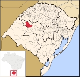
Santiago (Portuguese
meaning Saint James) is a municipality
of the western part of the state of Rio Grande do Sul
, Brazil
. It serves the capital of the microregion
of the same name
. Its area is 3,264.3 km² and its population was 51,375 in 2003. Its elevation is at 361 m. It is located 450 km west of the state capital of Porto Alegre
and northeast of Alegrete
. Its nickname of the city is "The Land of the Poets".
Santiago Airport
serves the city.
! colspan="2" | Map
|---- bgcolor="#FFFFFF"
! colspan="2" align="center" |
! colspan="2" | Statistics
|---- bgcolor="#FFFFFF"
| State: || Rio Grande do Sul
Rio Grande do Sul
Rio Grande do Sul is the southernmost state in Brazil, and the state with the fifth highest Human Development Index in the country. In this state is located the southernmost city in the country, Chuí, on the border with Uruguay. In the region of Bento Gonçalves and Caxias do Sul, the largest wine...
|---- bgcolor="#FFFFFF"
| Meso-region: || Westcentral Rio Grande do Sul
(Centro Ocidental Rio-Grandense)
Centro Ocidental Rio-Grandense
The Centro Ocidental Rio-Grandense is one of the seven meso-regions of the state of Rio Grande do Sul in Brazil. It consists of the union of 31 municipalities, grouped in three microregions.-Microrregions:* Restinga Seca* Santa Maria* Santiago...
|---- bgcolor="#FFFFFF"
| Micro-Region: || Santiago
Santiago (micro-region)
The Santiago micro-region is a micro-region in the western part of the state of Rio Grande do Sul, Brazil. The area is 10,750.721 km².- Municipalities:* Capão do Cipó* Itacurubi* Jari* Júlio de Castilhos* Pinhal Grande...
(capital)
|---- bgcolor="#FFFFFF"
| Founded: || January 4, 1984
|---- bgcolor="#FFFFFF" valign="top"
| Location
Location (geography)
The terms location and place in geography are used to identify a point or an area on the Earth's surface or elsewhere. The term 'location' generally implies a higher degree of can certainty than "place" which often has an ambiguous boundary relying more on human/social attributes of place identity...
: || 29.192/29° 11' 30" S lat.
54.872/54° 52' 2" W long.
|---- bgcolor="#FFFFFF"
| Area
Area
Area is a quantity that expresses the extent of a two-dimensional surface or shape in the plane. Area can be understood as the amount of material with a given thickness that would be necessary to fashion a model of the shape, or the amount of paint necessary to cover the surface with a single coat...
: || 3,264.3 km²
|---- bgcolor="#FFFFFF"
| Population
Population
A population is all the organisms that both belong to the same group or species and live in the same geographical area. The area that is used to define a sexual population is such that inter-breeding is possible between any pair within the area and more probable than cross-breeding with individuals...
(2003):
- Total
- Change
- Density ||
51,375
-
15.73/km²
|---- bgcolor="#FFFFFF"
| Elevation
Elevation
The elevation of a geographic location is its height above a fixed reference point, most commonly a reference geoid, a mathematical model of the Earth's sea level as an equipotential gravitational surface ....
: || 409 m
|---- bgcolor="#FFFFFF"
| Postal code: || 97700-xxx
{| border="1" cellpadding="2" cellspacing="0" style="float:right; empty-cells:show; margin-left:1em; margin-bottom:0,5em; background:#FFDEAD;"
! colspan="2" | Map
|---- bgcolor="#FFFFFF"
! colspan="2" align="center" |
! colspan="2" | Statistics
|---- bgcolor="#FFFFFF"
| State: || Rio Grande do Sul
Rio Grande do Sul
Rio Grande do Sul is the southernmost state in Brazil, and the state with the fifth highest Human Development Index in the country. In this state is located the southernmost city in the country, Chuí, on the border with Uruguay. In the region of Bento Gonçalves and Caxias do Sul, the largest wine...
|---- bgcolor="#FFFFFF"
| Meso-region: || Westcentral Rio Grande do Sul
(Centro Ocidental Rio-Grandense)
Centro Ocidental Rio-Grandense
The Centro Ocidental Rio-Grandense is one of the seven meso-regions of the state of Rio Grande do Sul in Brazil. It consists of the union of 31 municipalities, grouped in three microregions.-Microrregions:* Restinga Seca* Santa Maria* Santiago...
|---- bgcolor="#FFFFFF"
| Micro-Region: || Santiago
Santiago (micro-region)
The Santiago micro-region is a micro-region in the western part of the state of Rio Grande do Sul, Brazil. The area is 10,750.721 km².- Municipalities:* Capão do Cipó* Itacurubi* Jari* Júlio de Castilhos* Pinhal Grande...
(capital)
|---- bgcolor="#FFFFFF"
| Founded: || January 4, 1984
|---- bgcolor="#FFFFFF" valign="top"
| Location
Location (geography)
The terms location and place in geography are used to identify a point or an area on the Earth's surface or elsewhere. The term 'location' generally implies a higher degree of can certainty than "place" which often has an ambiguous boundary relying more on human/social attributes of place identity...
: || 29.192/29° 11' 30" S lat.
54.872/54° 52' 2" W long.
|---- bgcolor="#FFFFFF"
| Area
Area
Area is a quantity that expresses the extent of a two-dimensional surface or shape in the plane. Area can be understood as the amount of material with a given thickness that would be necessary to fashion a model of the shape, or the amount of paint necessary to cover the surface with a single coat...
: || 3,264.3 km²
|---- bgcolor="#FFFFFF"
| Population
Population
A population is all the organisms that both belong to the same group or species and live in the same geographical area. The area that is used to define a sexual population is such that inter-breeding is possible between any pair within the area and more probable than cross-breeding with individuals...
(2003):
- Total
- Change
- Density ||
51,375
-
15.73/km²
|---- bgcolor="#FFFFFF"
| Elevation
Elevation
The elevation of a geographic location is its height above a fixed reference point, most commonly a reference geoid, a mathematical model of the Earth's sea level as an equipotential gravitational surface ....
: || 409 m
|---- bgcolor="#FFFFFF"
| Postal code: || 97700-xxx
|}
Santiago (Portuguese
Portuguese language
Portuguese is a Romance language that arose in the medieval Kingdom of Galicia, nowadays Galicia and Northern Portugal. The southern part of the Kingdom of Galicia became independent as the County of Portugal in 1095...
meaning Saint James) is a municipality
Municipality
A municipality is essentially an urban administrative division having corporate status and usually powers of self-government. It can also be used to mean the governing body of a municipality. A municipality is a general-purpose administrative subdivision, as opposed to a special-purpose district...
of the western part of the state of Rio Grande do Sul
Rio Grande do Sul
Rio Grande do Sul is the southernmost state in Brazil, and the state with the fifth highest Human Development Index in the country. In this state is located the southernmost city in the country, Chuí, on the border with Uruguay. In the region of Bento Gonçalves and Caxias do Sul, the largest wine...
, Brazil
Brazil
Brazil , officially the Federative Republic of Brazil , is the largest country in South America. It is the world's fifth largest country, both by geographical area and by population with over 192 million people...
. It serves the capital of the microregion
Microregion (Brazil)
Microregions are legally defined administrative areas in Brazil consisting of groups of municipalities bordering urban areas. Microregions are grouped together into mesoregions....
of the same name
Santiago (micro-region)
The Santiago micro-region is a micro-region in the western part of the state of Rio Grande do Sul, Brazil. The area is 10,750.721 km².- Municipalities:* Capão do Cipó* Itacurubi* Jari* Júlio de Castilhos* Pinhal Grande...
. Its area is 3,264.3 km² and its population was 51,375 in 2003. Its elevation is at 361 m. It is located 450 km west of the state capital of Porto Alegre
Porto Alegre
Porto Alegre is the tenth most populous municipality in Brazil, with 1,409,939 inhabitants, and the centre of Brazil's fourth largest metropolitan area . It is also the capital city of the southernmost Brazilian state of Rio Grande do Sul. The city is the southernmost capital city of a Brazilian...
and northeast of Alegrete
Alegrete
Alegrete is a town and a municipality in Rio Grande do Sul located in southern Brazil. Its medium altitude is 102 m. Its estimated population in 2008 was 78,984 inhabitants and the total area is 7,803.967 km² . Its inhabitants are called Alegretenses.Alegrete was settled in 1816 and became a...
. Its nickname of the city is "The Land of the Poets".
Santiago Airport
Santiago Airport (Brazil)
Santiago Airport is the airport serving Santiago, Brazil.-External links:...
serves the city.
Neighboring municipalities
- BossorocaBossorocaBossoroca is a municipality of the [western part of the state of Rio Grande do Sul, Brazil. The origin of the name comes from the Tupi words iby meaning earth and soroc which combines to mean erosion...
- Capão do CipóCapão do CipóCapão do Cipó is a municipality of the western part of the state of Rio Grande do Sul, Brazil. and its population was 2,623 in 2003. It is located 627 km west of the state capital of Porto Alegre, northeast of Alegrete....
- TupanciretãTupanciretãTupanciretã is a municipality of the western part of the state of Rio Grande do Sul, Brazil. Its area is 2,253.1 km² and its population was 21,763 in 2004. Its elevation is at 465 m. The origin of the name comes from the Tupi language. It is located west of the state capital of Porto Alegre...
- JariJari, Rio Grande do SulJari is a municipality of the western part of the state of Rio Grande do Sul, Brazil. Its area is 856.459 km² and its population was 3,673 in 2003. Its elevation is at 441 m. The origin of the name comes from the Tupi language...
- JaguariJaguari-See also:*List of municipalities in Rio Grande do Sul...
- Nova Esperança do SulNova Esperança do SulNova Esperança do Sul is a municipality in the state Rio Grande do Sul, Brazil.-See also:*List of municipalities in Rio Grande do Sul...
- São Francisco de Assis
- UnistaldaUnistaldaUnistalda is a municipality of the western part of the state of Rio Grande do Sul, Brazil. Its area is 603.41 km² and its population was 2,699 in 2003. Its elevation is at 361 m...
- ItacurubiItacurubiItacurubi is a municipality of the western part of the state of Rio Grande do Sul, Brazil. Its area is 1,120.8 km² and its population was 3,571 in 2003. Its elevation is at 169 m. The origin of the name comes from the Tupi language...
History
In about 1860, it began the settlement of the region. The colony was first founded by 350 Germans, 14 Belgians, 5 French persons and 4 Swiss persons. Colonel José Maria Pereira de Campos created and organized the colony of Ijuí and brought Europeans to the area. The Italians arrived in the 1880s, as the century passed, with the establishment of the colony of Jaguari, the localities of Sanga da Areia and Ernesto Alves. In 1834, Arsene Isabelle, a French diplomat, in ways between the area, refers to a locality of Boqueirão de Santiago, its existence of three to four ranches. The Germans and the Italians form a large influx of European immigration, a mixture with other nationalities which saw Belgians, Swiss, Polish and French immigration. In synthesis, the colonies were established in 1860 and had diverse types of humans in the municipality of Santiago, with no other municipalities, the population became predominantly European descent.Education
Santiago has a campus of the Universidade Regional Integrada do Alto Uruguai e das MissõesRadio
- Verdes Pampas FM Website, Live broadcast
- Rádio Iguaçu FM Website, Live broadcast
- Rádio SantiagoWebsite
External links
- Officual Website
- Universidade Regional Integrada - Campus Santiago-RS
- Santiago-RS
- Santiago Flogger e Região
- http://www.citybrazil.com.br/rs/santiago/
- Map and Aerial photos:
- Coordinates: 29°11′30"S 54°52′2"W
- Street maps: Street map from Mapquest, MapPoint or Google
- Satellite images and Aerial photos: Google