

São Francisco de Assis
Encyclopedia
{| border="1" cellpadding="2" cellspacing="0" style="float:right; empty-cells:show; margin-left:1em; margin-bottom:0,5em; background:#FFDEAD;"
|-
! colspan="2" | Map
|---- bgcolor="#FFFFFF"
! colspan="2" align="center" |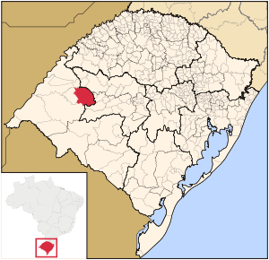 |-
|-
! colspan="2" | Statistics
|---- bgcolor="#FFFFFF"
| State: || Rio Grande do Sul
|---- bgcolor="#FFFFFF"
| Meso-region: || Southwestern Rio Grande do Sul
(Sudoeste Rio-Grandense)
|---- bgcolor="#FFFFFF"
| Micro-Region: || Campanha Ocidental
|---- bgcolor="#FFFFFF"
| Founded: || January 4, 1884
|---- bgcolor="#FFFFFF" valign="top"
| Location
: || 30.5503/30° 33' 1" S lat.
56.1285/56° 7' 52" W long.
|---- bgcolor="#FFFFFF"
| Area
: || 2,503.9 km²
|---- bgcolor="#FFFFFF"
| Population
(2003):
- Total
- Change
- Density ||
20,645
-
8.24/km²
|---- bgcolor="#FFFFFF"
| Elevation
: || 151 m
|---- bgcolor="#FFFFFF"
| Postal code: || 97610-xxx
{| border="1" cellpadding="2" cellspacing="0" style="float:right; empty-cells:show; margin-left:1em; margin-bottom:0,5em; background:#FFDEAD;"
|-
! colspan="2" | Map
|---- bgcolor="#FFFFFF"
! colspan="2" align="center" |
|-
! colspan="2" | Statistics
|---- bgcolor="#FFFFFF"
| State: || Rio Grande do Sul
|---- bgcolor="#FFFFFF"
| Meso-region: || Southwestern Rio Grande do Sul
(Sudoeste Rio-Grandense)
|---- bgcolor="#FFFFFF"
| Micro-Region: || Campanha Ocidental
|---- bgcolor="#FFFFFF"
| Founded: || January 4, 1884
|---- bgcolor="#FFFFFF" valign="top"
| Location
: || 30.5503/30° 33' 1" S lat.
56.1285/56° 7' 52" W long.
|---- bgcolor="#FFFFFF"
| Area
: || 2,503.9 km²
|---- bgcolor="#FFFFFF"
| Population
(2003):
- Total
- Change
- Density ||
20,645
-
8.24/km²
|---- bgcolor="#FFFFFF"
| Elevation
: || 151 m
|---- bgcolor="#FFFFFF"
| Postal code: || 97610-xxx
|}
São Francisco de Assis is a small Brazil
ian town in the western part of the state of Rio Grande do Sul
. It has a population of 20,645 (2005). Its elevation is 151 m. It has an area of 2,530.9 km². It is located 434 km west of the state capital of Porto Alegre
. The nickname of the city is Sao Chico.
The city is situated by the Jaguari
.
The city stays next to santa maria. They plant crops and produce milk.
|-
! colspan="2" | Map
|---- bgcolor="#FFFFFF"
! colspan="2" align="center" |
! colspan="2" | Statistics
|---- bgcolor="#FFFFFF"
| State: || Rio Grande do Sul
Rio Grande do Sul
Rio Grande do Sul is the southernmost state in Brazil, and the state with the fifth highest Human Development Index in the country. In this state is located the southernmost city in the country, Chuí, on the border with Uruguay. In the region of Bento Gonçalves and Caxias do Sul, the largest wine...
|---- bgcolor="#FFFFFF"
| Meso-region: || Southwestern Rio Grande do Sul
(Sudoeste Rio-Grandense)
|---- bgcolor="#FFFFFF"
| Micro-Region: || Campanha Ocidental
Campanha Ocidental
The Campanha Ocidental micro-region is a micro-region in the western part of the state of Rio Grande do Sul, Brazil...
|---- bgcolor="#FFFFFF"
| Founded: || January 4, 1884
|---- bgcolor="#FFFFFF" valign="top"
| Location
Location (geography)
The terms location and place in geography are used to identify a point or an area on the Earth's surface or elsewhere. The term 'location' generally implies a higher degree of can certainty than "place" which often has an ambiguous boundary relying more on human/social attributes of place identity...
: || 30.5503/30° 33' 1" S lat.
56.1285/56° 7' 52" W long.
|---- bgcolor="#FFFFFF"
| Area
Area
Area is a quantity that expresses the extent of a two-dimensional surface or shape in the plane. Area can be understood as the amount of material with a given thickness that would be necessary to fashion a model of the shape, or the amount of paint necessary to cover the surface with a single coat...
: || 2,503.9 km²
|---- bgcolor="#FFFFFF"
| Population
Population
A population is all the organisms that both belong to the same group or species and live in the same geographical area. The area that is used to define a sexual population is such that inter-breeding is possible between any pair within the area and more probable than cross-breeding with individuals...
(2003):
- Total
- Change
- Density ||
20,645
-
8.24/km²
|---- bgcolor="#FFFFFF"
| Elevation
Elevation
The elevation of a geographic location is its height above a fixed reference point, most commonly a reference geoid, a mathematical model of the Earth's sea level as an equipotential gravitational surface ....
: || 151 m
|---- bgcolor="#FFFFFF"
| Postal code: || 97610-xxx
{| border="1" cellpadding="2" cellspacing="0" style="float:right; empty-cells:show; margin-left:1em; margin-bottom:0,5em; background:#FFDEAD;"
|-
! colspan="2" | Map
|---- bgcolor="#FFFFFF"
! colspan="2" align="center" |
! colspan="2" | Statistics
|---- bgcolor="#FFFFFF"
| State: || Rio Grande do Sul
Rio Grande do Sul
Rio Grande do Sul is the southernmost state in Brazil, and the state with the fifth highest Human Development Index in the country. In this state is located the southernmost city in the country, Chuí, on the border with Uruguay. In the region of Bento Gonçalves and Caxias do Sul, the largest wine...
|---- bgcolor="#FFFFFF"
| Meso-region: || Southwestern Rio Grande do Sul
(Sudoeste Rio-Grandense)
|---- bgcolor="#FFFFFF"
| Micro-Region: || Campanha Ocidental
Campanha Ocidental
The Campanha Ocidental micro-region is a micro-region in the western part of the state of Rio Grande do Sul, Brazil...
|---- bgcolor="#FFFFFF"
| Founded: || January 4, 1884
|---- bgcolor="#FFFFFF" valign="top"
| Location
Location (geography)
The terms location and place in geography are used to identify a point or an area on the Earth's surface or elsewhere. The term 'location' generally implies a higher degree of can certainty than "place" which often has an ambiguous boundary relying more on human/social attributes of place identity...
: || 30.5503/30° 33' 1" S lat.
56.1285/56° 7' 52" W long.
|---- bgcolor="#FFFFFF"
| Area
Area
Area is a quantity that expresses the extent of a two-dimensional surface or shape in the plane. Area can be understood as the amount of material with a given thickness that would be necessary to fashion a model of the shape, or the amount of paint necessary to cover the surface with a single coat...
: || 2,503.9 km²
|---- bgcolor="#FFFFFF"
| Population
Population
A population is all the organisms that both belong to the same group or species and live in the same geographical area. The area that is used to define a sexual population is such that inter-breeding is possible between any pair within the area and more probable than cross-breeding with individuals...
(2003):
- Total
- Change
- Density ||
20,645
-
8.24/km²
|---- bgcolor="#FFFFFF"
| Elevation
Elevation
The elevation of a geographic location is its height above a fixed reference point, most commonly a reference geoid, a mathematical model of the Earth's sea level as an equipotential gravitational surface ....
: || 151 m
|---- bgcolor="#FFFFFF"
| Postal code: || 97610-xxx
|}
São Francisco de Assis is a small Brazil
Brazil
Brazil , officially the Federative Republic of Brazil , is the largest country in South America. It is the world's fifth largest country, both by geographical area and by population with over 192 million people...
ian town in the western part of the state of Rio Grande do Sul
Rio Grande do Sul
Rio Grande do Sul is the southernmost state in Brazil, and the state with the fifth highest Human Development Index in the country. In this state is located the southernmost city in the country, Chuí, on the border with Uruguay. In the region of Bento Gonçalves and Caxias do Sul, the largest wine...
. It has a population of 20,645 (2005). Its elevation is 151 m. It has an area of 2,530.9 km². It is located 434 km west of the state capital of Porto Alegre
Porto Alegre
Porto Alegre is the tenth most populous municipality in Brazil, with 1,409,939 inhabitants, and the centre of Brazil's fourth largest metropolitan area . It is also the capital city of the southernmost Brazilian state of Rio Grande do Sul. The city is the southernmost capital city of a Brazilian...
. The nickname of the city is Sao Chico.
The city is situated by the Jaguari
Jaguari
-See also:*List of municipalities in Rio Grande do Sul...
.
Other
São Francisco de Assis has a school or a collegiate, churches and a few squares and parks.The city stays next to santa maria. They plant crops and produce milk.
External links
- http://www.citybrazil.com.br/rs/saofranciscoassis/
- Map and Aerial photos:
- Coordinates: 29°33′1"S 55°7′52"W
- Street maps: Street map from Mapquest, MapPoint or Google
- Satellite images and Aerial photos: Google