
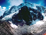
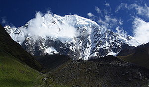
Salcantay
Encyclopedia
Salcantay or Salkantay (Nevado Salkantay), Sallqantay in Quechua
is the highest peak of the Cordillera Vilcabamba, part of the Peru
vian Andes
. It is located in the Cusco Region
, about 60 km (37.3 mi) west-northwest of the city of Cusco
. It is the 38th highest peak in the Andes, and the twelfth highest in Peru. However, as a range highpoint in deeply incised terrain, it is the second most topographically prominent
peak in the country, after Huascarán
.
, 1953, pp. 387-396. with great vertical relief, particularly above the low valleys to the north, which are tributaries of the Amazon River
.
Salcantay was first climbed in 1952 by a French
-American
expedition comprising Fred D. Ayres, David Michael, Jr., John C. Oberlin, W. V. Graham Matthews, Austen F. Riggs, George I. Bell, Claude Kogan, M. Bernard Pierre, and Jean Guillemin. All except Oberlin, Riggs, and Guillemin made the summit.
The standard route on the mountain is the Northeast ridge. Accessing the route typically involves three days of travel from Cusco
. The climb involves about 1800 m (5,905.5 ft) of vertical gain, on glacier, snow, ice, and some rock. The route is graded AD on the French adjectival scale.
The name Salkantay is from sallqa, a Quechua
word meaning wild, uncivilized, savage, or invincible, and was recorded as early as 1583.
The name is thus often translated as "Savage Mountain".
Directly to the north of Salkantay lies Machu Picchu
, which is at the end of a ridge that extends down from this mountain. Viewed from Machu Picchu's main sundial, the Southern Cross is above Salkantay's summit when at its highest point in the sky during the rainy season. The Incas associated this alignment with concepts of rain and fertility, and considered Salkantay to be one of the principal deities controlling weather and fertility in the region west of Cuzco.
Quechua languages
Quechua is a Native South American language family and dialect cluster spoken primarily in the Andes of South America, derived from an original common ancestor language, Proto-Quechua. It is the most widely spoken language family of the indigenous peoples of the Americas, with a total of probably...
is the highest peak of the Cordillera Vilcabamba, part of the Peru
Peru
Peru , officially the Republic of Peru , is a country in western South America. It is bordered on the north by Ecuador and Colombia, on the east by Brazil, on the southeast by Bolivia, on the south by Chile, and on the west by the Pacific Ocean....
vian Andes
Andes
The Andes is the world's longest continental mountain range. It is a continual range of highlands along the western coast of South America. This range is about long, about to wide , and of an average height of about .Along its length, the Andes is split into several ranges, which are separated...
. It is located in the Cusco Region
Cusco Region
Cusco is a region in Peru. It is bordered by the Ucayali Region on the north; the Madre de Dios and Puno regions on the east; the Arequipa Region on the south; and the Apurímac, Ayacucho and Junín regions on the west...
, about 60 km (37.3 mi) west-northwest of the city of Cusco
Cusco
Cusco , often spelled Cuzco , is a city in southeastern Peru, near the Urubamba Valley of the Andes mountain range. It is the capital of the Cusco Region as well as the Cuzco Province. In 2007, the city had a population of 358,935 which was triple the figure of 20 years ago...
. It is the 38th highest peak in the Andes, and the twelfth highest in Peru. However, as a range highpoint in deeply incised terrain, it is the second most topographically prominent
Topographic prominence
In topography, prominence, also known as autonomous height, relative height, shoulder drop , or prime factor , categorizes the height of the mountain's or hill's summit by the elevation between it and the lowest contour line encircling it and no higher summit...
peak in the country, after Huascarán
Huascarán
Huascarán or Nevado Huascarán is a mountain in the Peruvian province of Yungay, situated in the Cordillera Blanca range of the Western Andes. The highest southern summit of Huascarán is the highest point in Peru, and all the Earth's Tropics...
.
Overview
Salcantay is a large, steep peak, "the most spectacular peak of the region",John C. Oberlin and W. V. Graham Matthews, "The First Ascent of Mount Salcantay", American Alpine JournalAmerican Alpine Journal
The American Alpine Journal is an annual magazine published by the American Alpine Club. Its mission is "to document and communicate mountain exploration."...
, 1953, pp. 387-396. with great vertical relief, particularly above the low valleys to the north, which are tributaries of the Amazon River
Amazon River
The Amazon of South America is the second longest river in the world and by far the largest by waterflow with an average discharge greater than the next seven largest rivers combined...
.
Salcantay was first climbed in 1952 by a French
France
The French Republic , The French Republic , The French Republic , (commonly known as France , is a unitary semi-presidential republic in Western Europe with several overseas territories and islands located on other continents and in the Indian, Pacific, and Atlantic oceans. Metropolitan France...
-American
United States
The United States of America is a federal constitutional republic comprising fifty states and a federal district...
expedition comprising Fred D. Ayres, David Michael, Jr., John C. Oberlin, W. V. Graham Matthews, Austen F. Riggs, George I. Bell, Claude Kogan, M. Bernard Pierre, and Jean Guillemin. All except Oberlin, Riggs, and Guillemin made the summit.
The standard route on the mountain is the Northeast ridge. Accessing the route typically involves three days of travel from Cusco
Cusco
Cusco , often spelled Cuzco , is a city in southeastern Peru, near the Urubamba Valley of the Andes mountain range. It is the capital of the Cusco Region as well as the Cuzco Province. In 2007, the city had a population of 358,935 which was triple the figure of 20 years ago...
. The climb involves about 1800 m (5,905.5 ft) of vertical gain, on glacier, snow, ice, and some rock. The route is graded AD on the French adjectival scale.
The name Salkantay is from sallqa, a Quechua
Quechua languages
Quechua is a Native South American language family and dialect cluster spoken primarily in the Andes of South America, derived from an original common ancestor language, Proto-Quechua. It is the most widely spoken language family of the indigenous peoples of the Americas, with a total of probably...
word meaning wild, uncivilized, savage, or invincible, and was recorded as early as 1583.
The name is thus often translated as "Savage Mountain".
Directly to the north of Salkantay lies Machu Picchu
Machu Picchu
Machu Picchu is a pre-Columbian 15th-century Inca site located above sea level. It is situated on a mountain ridge above the Urubamba Valley in Peru, which is northwest of Cusco and through which the Urubamba River flows. Most archaeologists believe that Machu Picchu was built as an estate for...
, which is at the end of a ridge that extends down from this mountain. Viewed from Machu Picchu's main sundial, the Southern Cross is above Salkantay's summit when at its highest point in the sky during the rainy season. The Incas associated this alignment with concepts of rain and fertility, and considered Salkantay to be one of the principal deities controlling weather and fertility in the region west of Cuzco.
Salcantay Trek
Salcantay's proximity to Machu Picchu makes trekking around it an attractive alternative to the oversubscribed Inca Trail. There are three possible routes starting from Mollepata. All three begin with a day of approach, heading north along a dirt road. Then they diverge:- The longest route, heads north to the base of the mountain, then turns right, following the east side of the mountain, then heads northeast to eventually join the Inca Trail itself at Wayllabamba. This route takes 4 days to reach the Inca Trail, then another 2 days to reach Machu Picchu.
- The most common route used by trekking companies heads north, then west around the west side of the mountain, over Salcantay Pass at 4600m. It continues as far as the village of La Playa, where buses usually make the connection to Santa Teresa. From here, trekkers walk to the Hydroelectric project then either train or walk to Aguas Calientes, at the base of Machu Picchu. This route takes 4 days in total.
- A more satisfying variation on this route turns right before reaching La Playa, over a ridge and arriving directly at Aguas Calientes two days later. This route takes 6 days in total.
External links
- Gallery of Salcantay photos annotated by trekkers at TrekEarth.com