
Kamphaeng Phet Province
Encyclopedia
Kamphaeng Phet is one of the provinces
(changwat) of Thailand
, located in the north of the country. Neighboring provinces are (from north clockwise) Sukhothai
, Phitsanulok
, Phichit, Nakhon Sawan
and Tak
.
Vajra meaning diamond
(or weapon of Indra
). Hence the name of the province literally means Diamond Wall.
 The main river of the province is the Ping
, one of the sources of the Chao Phraya river. River flats make up much of the east of the province, while the west is mostly mountains covered with forests.
One of the most well-known products of the province is banana. Banana festivals take place in the province every year, to thank the gods for the harvest.
in the 14th century, then known under its old name Chakangrao. It formed an important part of the defence system of the kingdom, as well as later of the Ayutthaya kingdom
.
shows the city walls surmounted by diamond
s, for the city name means diamond wall. The provincial tree is the areca nut palm (Acacia catechu) and the provincial flower the Bullet Wood (Mimusops elengi
).
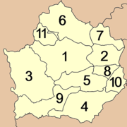 The province is subdivided in 11 districts (amphoe
). These are further subdivided into 78 subdistricts (tambon
) and 823 villages (muban
).

products, sculptures of demons and celestial and human beings used to decorate Chedi bases or Vihans.
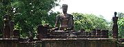
Kamphaeng Phet Historical Park
is an archeological site in Kamphaeng Phet
, Thailand
. Along with Sukhothai Historical Park
and Si Satchanalai historical park
, it is a part of the UNESCO
World Heritage Site
Historic Town of Sukhothai and Associated Historic Towns
. Major features in the Kamphaeng Phet Historical Park include archaeological remains of ancient sites such as Mueang Chakangrao to the east of the Ping River, Mueang Nakhon Chum to the west and Mueang Trai Trueng some 18 km from the town to the southwest.
Kamphaeng Phet Province Museum (พิพิธภัณฑสถานจังหวัดกำแพงเพชร เฉลิมพระเกียรติ) nearby is made up of groups of Central Region applied architectural style structures. There are exhibitions on the local history with replicas of the city, lifestyle and urban and hill tribal customs and traditions.
Mueang Nakhon Chum (เมืองนครชุม) is an ancient town on the west bank of the Ping River. Its 2-3 metre-high earthen walls run along the waterway. It is in this area that the famous religious tablets of Kamphaeng Phet have been discovered. Within the city walls are a couple of ancient sites such as the Kamphaeng Pom Thung Sethi (กำแพงป้อมทุ่งเศรษฐี) located on Phahonyothin Road just before entering the town. It is part of the laterite fortifications 83 metres long and 6 metres tall.
Wat Phra Borom That (วัดพระบรมธาตุ) is a temple situated in the centre of Mueang Nakhon Chum featuring a Burmese-style Chedi. To the south is an Ubosot housing several Sukhothai- and Ayutthaya-style bronze Buddha statues. The Chedi itself is believed to originally have been a Sukhothai-type structure, its style having been altered during a restoration work financed by a wealthy Burmese about a century ago.
Another ancient town is Mueang Trai Trueng. It was built by King Chaisiri of Chiang Rai who fled invading enemy in 1542 B.E. (circa 999). Today most of the structures are in disrepair with only ruins of Chedis and ramparts. The town is about 18 km from Kamphaeng Phet on the Kamphaeng Phet-Khlong Lan road.
Talat Kluai Khai (ตลาดกล้วยไข่) is on the Kamphaeng Phet-Nakhon Sawan highway at Km.343. Scores of roadside stalls display and sell both raw and ripe Kluai Khai (a type of bananas).
Phra Ruang Hot Spring ( Bueng Sap) (บ่อน้ำพุร้อนพระร่วง (บึงสาบ) is located at Mu 3, Tambon Lan Dok Mai, 13 km from Kamphaeng Phet, 12 km on the left side off Highway No. 101. The 5 spots of hot spring naturally took place from under the ground. The temperature is approximately 50-65 °C. From a test of the Ministry of Public Health, there is neither contamination nor diseases, which are too harmful in accordance with the standard.
Khlong Lan National Park (อุทยานแห่งชาติคลองลาน) covers an area of some 300 km² over mountain ranges to the west of the province. The highest peak is about 1,400 metres. Of mainly virgin jungles, it is the source of several streams which flow into the Ping River. The park headquarters is near the Khlong Lan waterfall, about 60 km from town. Attractions within the park include the 95-metre high Khlong Lan Fall with scenic surroundings, and the Khlong Nam Lai Fall (น้ำตกคลองน้ำไหล), a 9-level cascade and located off Highway no.1117 at Km. 35 and 10 km further on). The Kaeng Ko Roi (แก่งเกาะร้อย) (off Highway No.1117 at Pong Nam Ron intersection) is a group of rock formations jutting out of the stream looking somewhat like all islands.
Mae Wong National Park (อุทยานแห่งชาติแม่วงก์) forms the border between Kamphaeng Phet and Nakhon Sawan and covers an area of about 894 square km. Most of the land is rich in various types of plants. Along the Khlong Lan -Umphang route passing through the park's area, which leads up to the mountains, are several viewing points between km 81 to 115. At Km. 102 is a beautiful road-side waterfall. Other falls within the park include the Mae Krasa (น้ำตกแม่กระสา), Mae Liwa (น้ำตกแม่ลีวา) and others.
Khlong Wang Chao National Park (อุทยานแห่งชาติคลองวังเจ้า) is located in King Amphoe Kosamphi Nakhon, 43 km from Kamphaeng Phet. This is an abundant forest with a density of naturally growing teak and beautiful waterfalls. Nearby the park, there is a hill tribe village.
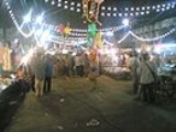
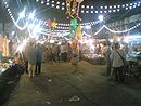
Kluai Khai Fair (งานสารทไทยกล้วยไข่เมืองกำแพง) is held in September each year to promote the local banana for which the province is famous. There are banana contests and competitions on the making of Krayasat (a local sweet), as well as many entertainment performances.
Provinces of Thailand
Thailand is divided into 76 provinces , which are geographically grouped into 6 regions. The capital Bangkok is not a province but a special administrative area and is included as the 77th province since it is administered at the same level as the other 76 provinces. The name of the provinces are...
(changwat) of Thailand
Thailand
Thailand , officially the Kingdom of Thailand , formerly known as Siam , is a country located at the centre of the Indochina peninsula and Southeast Asia. It is bordered to the north by Burma and Laos, to the east by Laos and Cambodia, to the south by the Gulf of Thailand and Malaysia, and to the...
, located in the north of the country. Neighboring provinces are (from north clockwise) Sukhothai
Sukhothai Province
Sukhothai is one of the northern provinces of Thailand. Neighboring provinces are Phrae, Uttaradit, Phitsanulok, Kamphaeng Phet, Tak, and Lampang...
, Phitsanulok
Phitsanulok Province
Phitsanulok is a provinces of Thailand, located in the north. Neighboring provinces are Loei, Phetchabun, Phichit, Kamphaeng Phet, Sukhothai, Uttaradit. In the north-east it also has a short border with Xaignabouli of Laos....
, Phichit, Nakhon Sawan
Nakhon Sawan Province
Nakhon Sawan is one of the provinces of Thailand. Neighboring provinces are Kamphaeng Phet, Phichit, Phetchabun, Lop Buri, Sing Buri, Chai Nat, Uthai Thani and Tak.- Etymology :...
and Tak
Tak Province
Tak is one of the northern provinces of Thailand. Neighboring provinces are Mae Hong Son, Chiang Mai, Lamphun, Lampang, Sukhothai, Kamphaeng Phet, Nakhon Sawan, Uthai Thani and Kanchanaburi...
.
Etymology
The word Kamphaeng means Wall, and the word Phet from SanskritSanskrit
Sanskrit , is a historical Indo-Aryan language and the primary liturgical language of Hinduism, Jainism and Buddhism.Buddhism: besides Pali, see Buddhist Hybrid Sanskrit Today, it is listed as one of the 22 scheduled languages of India and is an official language of the state of Uttarakhand...
Vajra meaning diamond
Diamond
In mineralogy, diamond is an allotrope of carbon, where the carbon atoms are arranged in a variation of the face-centered cubic crystal structure called a diamond lattice. Diamond is less stable than graphite, but the conversion rate from diamond to graphite is negligible at ambient conditions...
(or weapon of Indra
Indra
' or is the King of the demi-gods or Devas and Lord of Heaven or Svargaloka in Hindu mythology. He is also the God of War, Storms, and Rainfall.Indra is one of the chief deities in the Rigveda...
). Hence the name of the province literally means Diamond Wall.
Geography
Ping River
The Ping River , along with the Nan River, is one of the two main contributaries of Chao Phraya River. It originates at Doi Chiang Dao in Chiang Dao district, Chiang Mai Province. After passing Chiang Mai town, it flows though the provinces Lamphun, Tak, and Kamphaeng Phet...
, one of the sources of the Chao Phraya river. River flats make up much of the east of the province, while the west is mostly mountains covered with forests.
One of the most well-known products of the province is banana. Banana festivals take place in the province every year, to thank the gods for the harvest.
History
Kamphaeng Phet already was a royal city in the Sukhothai kingdomSukhothai kingdom
The Sukhothai Kingdom ) was an early kingdom in the area around the city Sukhothai, in north central Thailand. The Kingdom existed from 1238 till 1438...
in the 14th century, then known under its old name Chakangrao. It formed an important part of the defence system of the kingdom, as well as later of the Ayutthaya kingdom
Ayutthaya kingdom
Ayutthaya was a Siamese kingdom that existed from 1350 to 1767. Ayutthaya was friendly towards foreign traders, including the Chinese, Vietnamese , Indians, Japanese and Persians, and later the Portuguese, Spanish, Dutch and French, permitting them to set up villages outside the walls of the...
.
Symbols
The provincial sealSeals of The Provinces of Thailand
-Present-day provinces of Thailand:This list includes all the seals of the Provinces of Thailand. It also includes the special administrative area of the capital, Bangkok.-Former Provinces:-External links:*...
shows the city walls surmounted by diamond
Diamond
In mineralogy, diamond is an allotrope of carbon, where the carbon atoms are arranged in a variation of the face-centered cubic crystal structure called a diamond lattice. Diamond is less stable than graphite, but the conversion rate from diamond to graphite is negligible at ambient conditions...
s, for the city name means diamond wall. The provincial tree is the areca nut palm (Acacia catechu) and the provincial flower the Bullet Wood (Mimusops elengi
Mimusops elengi
Mimusops elengi is a medium-sized evergreen tree found in tropical forests in South Asia, Southeast Asia, and Northern Australia. English common names include Spanish cherry,, Medlar, and Bullet wood...
).
Administrative divisions
Amphoe
An amphoe is the second level administrative subdivision of Thailand. Usually translated as district, amphoe make up the provinces, and are analogous to a county seat...
). These are further subdivided into 78 subdistricts (tambon
Tambon
Tambon is a local government unit in Thailand. Below district and province , they form the third administrative subdivision level. As of the 2009 there are 7255 tambon, not including the 169 khwaeng of Bangkok, which are set at the same administrative level, thus every district contains 8-10 tambon...
) and 823 villages (muban
Muban
Muban is the lowest administrative subdivision of Thailand. Usually translated as village, they are the subdivision of tambon. As of 2008, there are 74944 administrative villages in Thailand. As of the 1990 census, the average village consisted of 144 households or 746 persons.A muban does not...
).
|
|
Tourism
Sights
Kamphaeng Phet National Museum (พิพิธภัณฑสถานแห่งชาติกำแพงเพชร), located on Pindamri Road in Mueang district, houses ancient objects and other antique arts articles from various eras found in the provincial town. These include sculptured and earthen designs, heads of Buddha statues, traditional celadonCeladon
Celadon is a term for ceramics denoting both a type of glaze and a ware of a specific color, also called celadon. This type of ware was invented in ancient China, such as in the Zhejiang province...
products, sculptures of demons and celestial and human beings used to decorate Chedi bases or Vihans.
Kamphaeng Phet Historical Park
Kamphaeng Phet Historical Park
Kamphaeng Phet Historical Park is an archeological site in Kamphaeng Phet, Thailand. Along with Sukhothai Historical Park and Si Satchanalai historical park, it is a part of the UNESCO World Heritage Site Historic Town of Sukhothai and Associated Historic Towns...
is an archeological site in Kamphaeng Phet
Kamphaeng Phet
Kamphaeng Phet is a town in northern Thailand, capital of the Kamphaeng Phet Province. It covers the complete tambon Nai Mueang of the Mueang Kamphaeng Phet district. As of 2005 it has a population of 30,114.-External links:...
, Thailand
Thailand
Thailand , officially the Kingdom of Thailand , formerly known as Siam , is a country located at the centre of the Indochina peninsula and Southeast Asia. It is bordered to the north by Burma and Laos, to the east by Laos and Cambodia, to the south by the Gulf of Thailand and Malaysia, and to the...
. Along with Sukhothai Historical Park
Sukhothai historical park
The Sukhothai Historical Park ) covers the ruins of Sukhothai, capital of the Sukhothai kingdom in the 13th and 14th centuries, in what is now the north of Thailand. It is located near the modern city of Sukhothai, capital of the province with the same name....
and Si Satchanalai historical park
Si Satchanalai historical park
The Si Satchanalai Historical Park is a historical park in Si Satchanalai district, Sukhothai Province, northern Thailand.The protection of the area was first announced in Volume 92, Part 112 of the Royal Gazette on August 2, 1961. In 1976 the restoration project was approved, and in July 1988 the...
, it is a part of the UNESCO
UNESCO
The United Nations Educational, Scientific and Cultural Organization is a specialized agency of the United Nations...
World Heritage Site
World Heritage Site
A UNESCO World Heritage Site is a place that is listed by the UNESCO as of special cultural or physical significance...
Historic Town of Sukhothai and Associated Historic Towns
Historic Town of Sukhothai and Associated Historic Towns
The Historic Town of Sukhothai and Associated Historic Towns is a Unesco World Heritage site which consists of Sukhothai historical park, Kamphaeng Phet historical park and Si Satchanalai historical park. These historical parks preserve the remains of the three main cities of the Sukhothai Kingdom...
. Major features in the Kamphaeng Phet Historical Park include archaeological remains of ancient sites such as Mueang Chakangrao to the east of the Ping River, Mueang Nakhon Chum to the west and Mueang Trai Trueng some 18 km from the town to the southwest.
Kamphaeng Phet Province Museum (พิพิธภัณฑสถานจังหวัดกำแพงเพชร เฉลิมพระเกียรติ) nearby is made up of groups of Central Region applied architectural style structures. There are exhibitions on the local history with replicas of the city, lifestyle and urban and hill tribal customs and traditions.
Mueang Nakhon Chum (เมืองนครชุม) is an ancient town on the west bank of the Ping River. Its 2-3 metre-high earthen walls run along the waterway. It is in this area that the famous religious tablets of Kamphaeng Phet have been discovered. Within the city walls are a couple of ancient sites such as the Kamphaeng Pom Thung Sethi (กำแพงป้อมทุ่งเศรษฐี) located on Phahonyothin Road just before entering the town. It is part of the laterite fortifications 83 metres long and 6 metres tall.
Wat Phra Borom That (วัดพระบรมธาตุ) is a temple situated in the centre of Mueang Nakhon Chum featuring a Burmese-style Chedi. To the south is an Ubosot housing several Sukhothai- and Ayutthaya-style bronze Buddha statues. The Chedi itself is believed to originally have been a Sukhothai-type structure, its style having been altered during a restoration work financed by a wealthy Burmese about a century ago.
Another ancient town is Mueang Trai Trueng. It was built by King Chaisiri of Chiang Rai who fled invading enemy in 1542 B.E. (circa 999). Today most of the structures are in disrepair with only ruins of Chedis and ramparts. The town is about 18 km from Kamphaeng Phet on the Kamphaeng Phet-Khlong Lan road.
Talat Kluai Khai (ตลาดกล้วยไข่) is on the Kamphaeng Phet-Nakhon Sawan highway at Km.343. Scores of roadside stalls display and sell both raw and ripe Kluai Khai (a type of bananas).
Phra Ruang Hot Spring ( Bueng Sap) (บ่อน้ำพุร้อนพระร่วง (บึงสาบ) is located at Mu 3, Tambon Lan Dok Mai, 13 km from Kamphaeng Phet, 12 km on the left side off Highway No. 101. The 5 spots of hot spring naturally took place from under the ground. The temperature is approximately 50-65 °C. From a test of the Ministry of Public Health, there is neither contamination nor diseases, which are too harmful in accordance with the standard.
Khlong Lan National Park (อุทยานแห่งชาติคลองลาน) covers an area of some 300 km² over mountain ranges to the west of the province. The highest peak is about 1,400 metres. Of mainly virgin jungles, it is the source of several streams which flow into the Ping River. The park headquarters is near the Khlong Lan waterfall, about 60 km from town. Attractions within the park include the 95-metre high Khlong Lan Fall with scenic surroundings, and the Khlong Nam Lai Fall (น้ำตกคลองน้ำไหล), a 9-level cascade and located off Highway no.1117 at Km. 35 and 10 km further on). The Kaeng Ko Roi (แก่งเกาะร้อย) (off Highway No.1117 at Pong Nam Ron intersection) is a group of rock formations jutting out of the stream looking somewhat like all islands.
Mae Wong National Park (อุทยานแห่งชาติแม่วงก์) forms the border between Kamphaeng Phet and Nakhon Sawan and covers an area of about 894 square km. Most of the land is rich in various types of plants. Along the Khlong Lan -Umphang route passing through the park's area, which leads up to the mountains, are several viewing points between km 81 to 115. At Km. 102 is a beautiful road-side waterfall. Other falls within the park include the Mae Krasa (น้ำตกแม่กระสา), Mae Liwa (น้ำตกแม่ลีวา) and others.
Khlong Wang Chao National Park (อุทยานแห่งชาติคลองวังเจ้า) is located in King Amphoe Kosamphi Nakhon, 43 km from Kamphaeng Phet. This is an abundant forest with a density of naturally growing teak and beautiful waterfalls. Nearby the park, there is a hill tribe village.
Local Products
Kluai Khai (mini banana) is a famous produce of this province. Raw and ripe bananas as well as other local produces such as sticky paste (made of rice, bean, sesame and sugar)Festivals
The Nop Phra Len Phleng Fair (งานนบพระเล่นเพลง) is held during the celebrations of Makha Bucha (around February). A tradition since the times of Sukhothai, it is described in the inscription stone found at Nakhon Chum of how processions were organised to pay homage to the town's major religious sites. The fair today consists of colorfully decorated parades of participants dressed in ancient attires crossing the Ping to pay homage to the Holy Relic on the Nakhon Chum side of the river.Kluai Khai Fair (งานสารทไทยกล้วยไข่เมืองกำแพง) is held in September each year to promote the local banana for which the province is famous. There are banana contests and competitions on the making of Krayasat (a local sweet), as well as many entertainment performances.
External links
- Website of Province (Thai)