
Saint Lucy Parish, Barbados
Encyclopedia
| Statistics | |
|---|---|
| Parish: | Saint Lucy |
| Area: | 36km² (14 sq. mi.) |
| Largest city: | Checker Hall |
| Population (2008 est.): | 10,323 inhab. |
| Population Density: | 286.75 inhab/km² |
| Parliamentary representation Parliament of Barbados The Parliament of Barbados is the national legislature of Barbados. It is accorded legislative supremacy by Chapter V of the Constitution of Barbados. The Parliament is bicameral in composition and is formally made up of: HM Queen Elizabeth II, Queen of Barbados The Parliament of Barbados is the... | |
| - House seats | 1 |
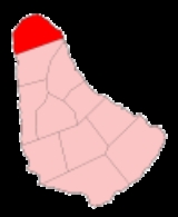
| Map | |
 | |
| Parishes of Barbados Parishes of Barbados The country of Barbados is currently subdivided into sub-regions known as parishes. According to the Act of the Barbados Parliament they are officially styled as the "Parish of as opposed to the U.S. styled naming convention with the name "Parish" coming after the name... | |
The parish
Parishes of Barbados
The country of Barbados is currently subdivided into sub-regions known as parishes. According to the Act of the Barbados Parliament they are officially styled as the "Parish of as opposed to the U.S. styled naming convention with the name "Parish" coming after the name...
of Saint Lucy ("St. Lucy") is the northern-most area in the country of Barbados
Barbados
Barbados is an island country in the Lesser Antilles. It is in length and as much as in width, amounting to . It is situated in the western area of the North Atlantic and 100 kilometres east of the Windward Islands and the Caribbean Sea; therein, it is about east of the islands of Saint...
. Saint Lucy is known for being the only parish of Barbados out of the eleven to be named after a female patron
Patron saint
A patron saint is a saint who is regarded as the intercessor and advocate in heaven of a nation, place, craft, activity, class, clan, family, or person...
saint
Saint
A saint is a holy person. In various religions, saints are people who are believed to have exceptional holiness.In Christian usage, "saint" refers to any believer who is "in Christ", and in whom Christ dwells, whether in heaven or in earth...
, Saint Lucy of Syracuse
Saint Lucy
Saint Lucy , also known as Saint Lucia, was a wealthy young Christian martyr who is venerated as a saint by Roman Catholic, Anglican, Lutheran, and Orthodox Christians. Her feast day in the West is 13 December; with a name derived from lux, lucis "light", she is the patron saint of those who are...
. Saint Lucy was the location of a United States Navy base
United States Navy Facility, Barbados
The Naval Facility Barbados, TWI was a naval base which was commissioned on 1 October 1957, with a complement of about 12 officers and about 88 enlisted personnel. It was located at site of Harrison's Point, in the Parish of Saint Lucy in the British colonial territory of Barbados of the West...
at Harrison's Point. Saint Lucy is also a peninsula
Peninsula
A peninsula is a piece of land that is bordered by water on three sides but connected to mainland. In many Germanic and Celtic languages and also in Baltic, Slavic and Hungarian, peninsulas are called "half-islands"....
, surrounded on three sides by the Atlantic Ocean
Atlantic Ocean
The Atlantic Ocean is the second-largest of the world's oceanic divisions. With a total area of about , it covers approximately 20% of the Earth's surface and about 26% of its water surface area...
to the north, east and west. To the south lies the neighbouring Parish of Saint Peter.
As the crow flies, Saint Lucy is the most distant part of Barbados from the capital city Bridgetown
Bridgetown
The city of Bridgetown , metropolitan pop 96,578 , is the capital and largest city of the nation of Barbados. Formerly, the Town of Saint Michael, the Greater Bridgetown area is located within the parish of Saint Michael...
, located in the parish of Saint Michael or Grantley Adams International Airport
Grantley Adams International Airport
Grantley Adams International Airport , is found in Seawell, Christ Church on the island of Barbados. The former name of the airport was Seawell Airport before being dedicated in honour of the first Premier of Barbados, Sir Grantley Herbert Adams in 1976. The airport's timezone is GMT –4, and is...
in Christ Church. Saint Lucy remains one of the less populated parts of the island because its remoteness.
In a bid to improve the economic fortunes of Saint Lucy, almost every leader of Barbados has grappled with various plans of how to turn around the development status of the Parish. One of the most recent ideas during the 1990s was to capitalise on a venture said to be in the works by Donald Trump
Donald Trump
Donald John Trump, Sr. is an American business magnate, television personality and author. He is the chairman and president of The Trump Organization and the founder of Trump Entertainment Resorts. Trump's extravagant lifestyle, outspoken manner and role on the NBC reality show The Apprentice have...
in neighbouring Saint Vincent and the Grenadines
Saint Vincent and the Grenadines
Saint Vincent and the Grenadines is an island country in the Lesser Antilles chain, namely in the southern portion of the Windward Islands, which lie at the southern end of the eastern border of the Caribbean Sea where the latter meets the Atlantic Ocean....
. It was being proposed that if Donald Trump moved ahead to develop a hotel in those islands, that Barbados could build a second seaport with large ships traveling directly to Saint Vincent and the Grenadines for wealthy land-owners at the Trump development to have easy access to the Grantley Adams airport in Barbados.
The closest major town to Saint Lucy in Barbados is Speightstown
Speightstown
Speightstown , also known as Little Bristol, is the second largest town centre of Barbados. It is situated north of the capital city of Bridgetown, in the northern parish of Saint Peter....
located in the parish of Saint Peter.
Saint Lucy is the birthplace of Barbados's first Prime Minister, Errol Barrow
Errol Barrow
Errol Walton Barrow, PC, QC was a Caribbean statesman and the first Prime Minister of Barbados. Born into a family of political and civic activists in the parish of Saint Lucy and educated at Harrison College, his sister Dame Nita Barrow also became a social activist, humanitarian leader and later...
. It is also the birthplace of two cricket
Cricket
Cricket is a bat-and-ball game played between two teams of 11 players on an oval-shaped field, at the centre of which is a rectangular 22-yard long pitch. One team bats, trying to score as many runs as possible while the other team bowls and fields, trying to dismiss the batsmen and thus limit the...
ers; Charlie Griffith
Charlie Griffith
Charles Christopher Griffith is a former West Indian cricketer who played in 28 Tests from 1960 to 1969. He formed a lethal fast bowling partnership with Wes Hall during the 1960s...
and Manny Martindale
Manny Martindale
Emmanuel Alfred Martindale was a West Indian cricketer who played in ten Tests from 1933 to 1939. He was a right-arm fast bowler and a lower-order right-handed batsman....
.
The historical Parish church for Saint Lucy is located in the Trents/Nessfield area of Saint Lucy.