
Saint James Parish, Barbados
Encyclopedia
| Statistics | |
|---|---|
| Parish: | Saint James |
| Area: | 31 km² (12 sq. mi.) |
| Largest City: | Holetown Holetown Holetown , is a small town located in the Caribbean island nation of Barbados. Holetown is located in the parish of Saint James on the sheltered west coast of the island.-History:... |
| Population (2008 est.): | 25,110 inhab. |
| Population Density: | 810 inhab/km² |
| Parliamentary representation Parliament of Barbados The Parliament of Barbados is the national legislature of Barbados. It is accorded legislative supremacy by Chapter V of the Constitution of Barbados. The Parliament is bicameral in composition and is formally made up of: HM Queen Elizabeth II, Queen of Barbados The Parliament of Barbados is the... | |
| - House seats | 3 |
| Map | |
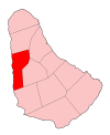 | |
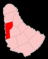
| Parishes of Barbados Parishes of Barbados The country of Barbados is currently subdivided into sub-regions known as parishes. According to the Act of the Barbados Parliament they are officially styled as the "Parish of as opposed to the U.S. styled naming convention with the name "Parish" coming after the name... | |
The parish
Parishes of Barbados
The country of Barbados is currently subdivided into sub-regions known as parishes. According to the Act of the Barbados Parliament they are officially styled as the "Parish of as opposed to the U.S. styled naming convention with the name "Parish" coming after the name...
of Saint James ("St. James") is an area located in the western part of the country of Barbados
Barbados
Barbados is an island country in the Lesser Antilles. It is in length and as much as in width, amounting to . It is situated in the western area of the North Atlantic and 100 kilometres east of the Windward Islands and the Caribbean Sea; therein, it is about east of the islands of Saint...
. Increasingly St. James is being known as the playground of the rich and famous, and haven for sun-starved tourists.
In local colloquium, St. James was known as the "Gold Coast", but due to ongoing popularity it is now referred to as the "Platinum Coast
Platinum Coast
The Platinum Coast is a stretch of powdery white sandy-beach in Barbados. Located to the North of Holetown. Its area title has been broadened in more recent times to include much of the coastline of the parish of Saint James. The Platinum Coast is a spot consisting mostly of "nouveau riche" to...
", reflective of the parishes many glitzy beach-front mansions, pristine beaches, luxury hotels and consistently high land prices. Many Barbadians say within the Platinum Coast there are as many as, 18 global billionaires own property somewhere within a 6-mile stretch of beach on the island.
The parish also has great historic significance, as it was here that the first British
British people
The British are citizens of the United Kingdom, of the Isle of Man, any of the Channel Islands, or of any of the British overseas territories, and their descendants...
settlers landed in 1625. Under the authority of King James
James I of England
James VI and I was King of Scots as James VI from 24 July 1567 and King of England and Ireland as James I from the union of the English and Scottish crowns on 24 March 1603...
, the British claimed Barbados upon landing in St. James' present-day city of Holetown
Holetown
Holetown , is a small town located in the Caribbean island nation of Barbados. Holetown is located in the parish of Saint James on the sheltered west coast of the island.-History:...
(formerly Jamestown, named after the King himself), this settlement turned Barbados into what would later be known as "Little England".
Noted for its shopping and restaurants, St. James is central to Barbados' bustling tourist industry, with historical attractions including the St. James Parish Church and the Portvale Sugar Factory - one of the few operational sugar factories on the island.
Though a haven for tourists and foreign expatriates, St. James is far from exclusive. As one of the bigger parishes, it is home to over 20,000 nationals strewn across its many districts, across various social strata. The parish is home to the prestigious Queen's College
Queen's College (Barbados)
Queen's College was established as a result of the recommendation of an Education Commission whose report suggested that Barbados required a first grade school for girls...
, one of the foremost schools not only in Barbados, but the Caribbean
Caribbean
The Caribbean is a crescent-shaped group of islands more than 2,000 miles long separating the Gulf of Mexico and the Caribbean Sea, to the west and south, from the Atlantic Ocean, to the east and north...
, founded over a century ago by a British plantation owner by the name of Col. Henry Drax. At its most rural, the parish's many villages (such as the seafront "Fitts Village") are abuzz with activity, near-familial camaraderie, and an active social atmosphere.
Parishes bordering Saint James
- Saint Andrew - East
- Saint Peter - North
- Saint Michael - South
- Saint Thomas - Southeast
Defined Boundaries
with St. Andrew: – Starting from the meeting point of the parishes of St. Peter, St. James and St. Andrew; then in a southerly direction along the line joining this point to the centre of the old millwall at Springhead Plantation; then in a straight line to a monument (B.5) at the acute bend in the public road at Gregg Farm: then in a southerly direction along this road to where it crosses the gully (monument (B.6) on the western side of the road): then along this gully to its junction with three other gullies. This is the meeting point of the parishes of St. James, St. Andrew and St. Thomas.with St. Peter: – Starting from the meeting point of the parishes of St. Peter, St. James and St. Andrew and continuing in an easterly direction to its junction with the public road leading from Rock Hall Plantation to Rock Hall Village: then in a north- westerly direction along this public road to its junction at Rock Hall Tenantry with a track leading to Roebuck Village; then along this track in a generally northerly direction to its junction at Roebuck Village with the unclassified public road leading from Four Hills Plantation to Indian Ground; then continuing in a generally northerly direction along this road to its junction with the public road leading from Orange Hill Plantation to Welchtown Plantation; then continuing in a northerly direction along this road to its junction at Welchtown Plantation with the public road leading from Farley Hill to Portland; then in a north-westerly direction along this road to its junction at Portland with the public road called Highway 1; then in an easterly and northerly direction along Highway 1 to the junction at Diamond Comer with the public road called Highway B; then in a generally easterly direction along Highway B passing through Nicholas and Cherry Tree Hill to the junction of this road with the public road leading to Boscobelle; then in a north-easterly direction along this road to the junction with the private road leading to Fosters Funland; then in a generally easterly direction along this road and along the southern section of the loop at the end; and then continuing in an easterly direction to the sea.
with St. Michael: – Starting from the meeting point of the parishes of St. James, St. Thomas, and St. Michael and proceeding generally westwards along the public road called Clermont Road to its junction with the public road called Husbands Road; then in a southerly direction along this road to its junction with University Drive; then in a westerly and southerly direction along University Drive to the centre of the roundabout at the intersection of this road and Highway 1; then in a north-westerly direction along Highway 1 to a point just south of its junction with an unclassified road called Batt's Rock Road; then from this point in a straight line (bearing 263°07'21") through a monument (B. 18) to the sea.
with St. Thomas: – Starting from the meeting point of the parishes of St. James, St. Andrew, and St. Thomas and proceeding along the gully in a south-westerly direction to the centre-line of the bridge at Lancaster where it crosses the public road known as Highway 2A; then in a generally southerly direction to its junction at St. Thomas’ Church with the public road leading from Seaview; then in a westerly direction along the public road to a point marked by a monument (B.8) placed on the southern side of the road; then in a southerly direction along a line joining this point to another monument (B.3) placed on the northern side of an unclassified road leading to Molyneux and to the centre line of the road; then in a westerly and southerly direction along this road to its junction with the public road leading from Bennetts Plantation to Sandy Lane; then in an easterly direction along this road to its junction at Bennetts with the public road called Highway 2A; then in a southerly direction along Highway 2A to its junction at Warrens with the public road called Clermont Road. This is the junction point of the parishes of St. James, St. Thomas, and St. Michael.