

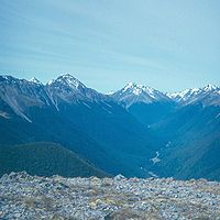
Sabine River, New Zealand
Encyclopedia
South Island
The South Island is the larger of the two major islands of New Zealand, the other being the more populous North Island. It is bordered to the north by Cook Strait, to the west by the Tasman Sea, to the south and east by the Pacific Ocean...
of New Zealand
New Zealand
New Zealand is an island country in the south-western Pacific Ocean comprising two main landmasses and numerous smaller islands. The country is situated some east of Australia across the Tasman Sea, and roughly south of the Pacific island nations of New Caledonia, Fiji, and Tonga...
. It is located in Nelson Lakes National Park
Nelson Lakes National Park
Nelson Lakes National Park is located in the South Island of New Zealand.It was formed in 1956 and covers some 1,020 km². It is centered at two large lakes, Rotoiti and Rotoroa. The park also includes surrounding valleys and mountain ranges...
.
There are two branches to the river—East Sabine and West Sabine. The West Sabine drains Lake Constance
Lake Constance, New Zealand
Lake Constance is an alpine lake in the South Island of New Zealand.It lies within the borders of the Nelson Lakes National Park. The lake is drained via an underground river into Blue Lake....
and the Blue Lake. The two branches join at the Sabine Forks, and flow into Lake Rotoroa. Apart from the upper reaches, which is open tussock and scrub, the river is set within unmodified beech
Beech
Beech is a genus of ten species of deciduous trees in the family Fagaceae, native to temperate Europe, Asia and North America.-Habit:...
forest. It is not a navigable river due to the rocky cascades along most of its length.
A tramping track runs along the river and forms the western branch of the Travers-Sabine tramping circuit. This route usually starts from Saint Arnaud
Saint Arnaud, New Zealand
Saint Arnaud is a small alpine village located in the north of New Zealand's South Island, west of the mountains of the Saint Arnaud Range and 90 kilometres southwest of Nelson near the historic Tophouse Settlement...
at the northern end of Lake Rotoiti. It follows the course of the Travers River
Travers River
The Travers River is in the South Island of New Zealand.It lies within the borders of the Nelson Lakes National Park. The valley through which the river flows is popular with trampers and is part of the Travers-Sabine tramping circuit, which follows a major portion of the river, starting from Kerr...
, goes up over the sub alpine Travers Saddle (1787 metres), and then descends along the East Sabine Valley and Sabine Valley to Lake Rotoroa
Lake Rotoroa
Lake Rotoroa lies within the borders of Nelson Lakes National Park in the South Island, New Zealand. The lake is fed by the D'Urville and Sabine rivers....
. A track also ascends the West Sabine to Blue Lake
Blue Lake, Tasman
Blue Lake is the name of a tiny lake in Nelson Lakes National Park, in the northern reaches of the Southern Alps. It is drained by the Sabine River, which is part of the Buller River system. It is fed from Lake Constance by an underground segment of the Sabine....
. This route continues over the Waiau Pass, eventually connecting with the St James Walkway
St James Walkway
The St James Walkway is a sub-alpine tramping track located in the Lewis Pass area of the South Island of New Zealand. It is administered by the Department of Conservation.Part of the track passes through the former St James Station.- Further reading :...
and Lewis Pass
Lewis Pass
Lewis Pass is a mountain pass in the South Island of New Zealand.The northernmost of the three main passes across the Southern Alps, it is higher than the Haast Pass, but slightly lower than Arthur's Pass...
.
Three tramping huts are located in the Sabine Valley: Sabine Hut (on the shore of Lake Rotoroa, near the mouth of the Sabine); West Sabine Hut (near the Sabine Forks); and Blue Lake Hut.