
Sagebrush Cooperative
Encyclopedia
The Sagebrush Cooperative is collaborative group based in southeastern Oregon
and adjacent portions of Idaho
and Nevada
involving land managers, owners, and interest groups with the goal of improved management and conservation of shrub steppe systems.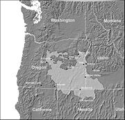
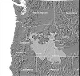
ecosystem, an icon of the western United States, is being recognized by many to be threatened or degraded across much of its range. Habitat for sagebrush steppe dependent species is being eliminated by energy development
, altered fire regime
s and rapid conversion to exotic annual grasslands and juniper woodlands. In recent years, the sagebrush steppe has received increasing attention and there is a need for regional coordination and assessment of the opportunities for partnerships and projects to better manage, conserve and restore key habitats. One of the largest remaining blocks of high quality sagebrush steppe is in the High Desert, a portion of several ecoregions spanning southeastern Oregon, northern Nevada and southwestern Idaho (Figure 1). This area includes the higher elevation portions of the Columbia Plateau
and northern Great Basin
from just south of the Blue Mountains
to the Sheldon National Wildlife Refuge
and the Owyhee
Uplands.
Despite the fact that the sagebrush steppe ecosystem is being increasingly recognized as important and threatened, there is remarkably little published data or references documenting current condition, trends, threats, or the effectiveness of recent management activities in sagebrush steppe for the region. Recent range-wide analyses spurred by the petitions to list the greater sage-grouse as an endangered species have documented broad trends across the west but do not include data or information at a scale useful for local prioritization and project planning.
Sagebrush steppe habitats emerged as priority habitats in the Oregon, Idaho, and Nevada state wildlife agency strategies (State Wildlife Plans) The Oregon Conservation Strategy identifies sagebrush steppe and shrublands as a Strategy Habitat and multiple sagebrush steppe dependent species as Strategy Species. The Idaho Comprehensive Wildlife Conservation Strategy identifies southern xeric shrubland and steppe, which includes multiple sagebrush steppe ecological systems, as a statewide Priority Habitat. The Idaho Strategy also identifies many associated Species of Greatest Conservation Need. The Nevada Wildlife Action Plan identifies sagebrush as a Key Habitat and eight sagebrush dependent species as Species of Conservation Priority. Each of the State Wildlife Plans identifies specific priority geographic areas for conservation of sagebrush steppe within the High Desert region (Appendix A).
Oregon
Oregon is a state in the Pacific Northwest region of the United States. It is located on the Pacific coast, with Washington to the north, California to the south, Nevada on the southeast and Idaho to the east. The Columbia and Snake rivers delineate much of Oregon's northern and eastern...
and adjacent portions of Idaho
Idaho
Idaho is a state in the Rocky Mountain area of the United States. The state's largest city and capital is Boise. Residents are called "Idahoans". Idaho was admitted to the Union on July 3, 1890, as the 43rd state....
and Nevada
Nevada
Nevada is a state in the western, mountain west, and southwestern regions of the United States. With an area of and a population of about 2.7 million, it is the 7th-largest and 35th-most populous state. Over two-thirds of Nevada's people live in the Las Vegas metropolitan area, which contains its...
involving land managers, owners, and interest groups with the goal of improved management and conservation of shrub steppe systems.
Why protect sagebrush?
The sagebrush steppeSagebrush steppe
The sagebrush steppe is a type of shrub-steppe, which is a dry-xeric environment and plant community found in the Western United States and western Canada...
ecosystem, an icon of the western United States, is being recognized by many to be threatened or degraded across much of its range. Habitat for sagebrush steppe dependent species is being eliminated by energy development
Energy development
Energy development is the effort to provide sufficient primary energy sources and secondary energy forms for supply, cost, impact on air pollution and water pollution, mitigation of climate change with renewable energy....
, altered fire regime
Fire regime
A fire regime is the pattern, frequency and intensity of the bushfires and wildfires that prevails in an area. It is an integral part of fire ecology, and renewal for certain types of ecosystems. If fires are too frequent, plants may be killed before they have matured, or before they have set...
s and rapid conversion to exotic annual grasslands and juniper woodlands. In recent years, the sagebrush steppe has received increasing attention and there is a need for regional coordination and assessment of the opportunities for partnerships and projects to better manage, conserve and restore key habitats. One of the largest remaining blocks of high quality sagebrush steppe is in the High Desert, a portion of several ecoregions spanning southeastern Oregon, northern Nevada and southwestern Idaho (Figure 1). This area includes the higher elevation portions of the Columbia Plateau
Columbia Plateau
The Columbia Plateau is a geologic and geographic region that lies across parts of the U.S. states of Washington, Oregon, and Idaho. It is a wide flood basalt plateau between the Cascade Range and the Rocky Mountains, cut through by the Columbia River...
and northern Great Basin
Great Basin
The Great Basin is the largest area of contiguous endorheic watersheds in North America and is noted for its arid conditions and Basin and Range topography that varies from the North American low point at Badwater Basin to the highest point of the contiguous United States, less than away at the...
from just south of the Blue Mountains
Blue Mountains (Oregon)
The Blue Mountains are a mountain range in the western United States, located largely in northeastern Oregon and stretching into southeastern Washington...
to the Sheldon National Wildlife Refuge
Sheldon National Wildlife Refuge
The Sheldon National Wildlife Refuge is a national wildlife refuge located on the northern border of the U.S. state of Nevada. A very small part extends northward into Oregon. It is managed by the United States Fish and Wildlife Service as the Nevada component of the Sheldon-Hart Mountain...
and the Owyhee
Owyhee River
The Owyhee River is a tributary of the Snake River located in northern Nevada, southwestern Idaho and southeastern Oregon in the United States. It is long. The river's drainage basin is in area, one of the largest subbasins of the Columbia Basin...
Uplands.
Despite the fact that the sagebrush steppe ecosystem is being increasingly recognized as important and threatened, there is remarkably little published data or references documenting current condition, trends, threats, or the effectiveness of recent management activities in sagebrush steppe for the region. Recent range-wide analyses spurred by the petitions to list the greater sage-grouse as an endangered species have documented broad trends across the west but do not include data or information at a scale useful for local prioritization and project planning.
Sagebrush steppe habitats emerged as priority habitats in the Oregon, Idaho, and Nevada state wildlife agency strategies (State Wildlife Plans) The Oregon Conservation Strategy identifies sagebrush steppe and shrublands as a Strategy Habitat and multiple sagebrush steppe dependent species as Strategy Species. The Idaho Comprehensive Wildlife Conservation Strategy identifies southern xeric shrubland and steppe, which includes multiple sagebrush steppe ecological systems, as a statewide Priority Habitat. The Idaho Strategy also identifies many associated Species of Greatest Conservation Need. The Nevada Wildlife Action Plan identifies sagebrush as a Key Habitat and eight sagebrush dependent species as Species of Conservation Priority. Each of the State Wildlife Plans identifies specific priority geographic areas for conservation of sagebrush steppe within the High Desert region (Appendix A).
What does the cooperative do?
- Works to identify strategies and priorities for successful conservation of sagebrush steppe at a regional scale.
- Shares information:
- Habitat and wildlife monitoring data;
- Best management practices;
- Monitoring methods;
- Analytical tools;
- Current scientific developments.
- Develops and distributes analytical tools.
- Identifies gaps in available information in order to direct research and funding.
- Helps find funding for projects.
- Put projects in larger context to be more effective regionally.
- Coordinates efforts of related organizations.
Members
- Bureau of Land ManagementBureau of Land ManagementThe Bureau of Land Management is an agency within the United States Department of the Interior which administers America's public lands, totaling approximately , or one-eighth of the landmass of the country. The BLM also manages of subsurface mineral estate underlying federal, state and private...
- Eastern Oregon Agricultural Research Center OSUOregon State UniversityOregon State University is a coeducational, public research university located in Corvallis, Oregon, United States. The university offers undergraduate, graduate and doctoral degrees and a multitude of research opportunities. There are more than 200 academic degree programs offered through the...
/USDA ARSAgricultural Research ServiceThe Agricultural Research Service is the principal in-house research agency of the United States Department of Agriculture . ARS is one of four agencies in USDA's Research, Education and Economics mission area... - Natural Resources Conservation ServiceNatural Resources Conservation ServiceThe Natural Resources Conservation Service , formerly known as the Soil Conservation Service , is an agency of the United States Department of Agriculture that provides technical assistance to farmers and other private landowners and managers.Its name was changed in 1994 during the Presidency of...
- Oregon Department of Fish and WildlifeOregon Department of Fish and WildlifeThe Oregon Department of Fish and Wildlife is an agency of the government of the U.S. state of Oregon responsible for programs protecting Oregon fish and wildlife resources and their habitats....
- Oregon Habitat Joint Venture
- Oregon Sage Grouse Conservation Planning Team
- Oregon Watershed Enhancement Board
- PRBO Conservation SciencePRBO Conservation SciencePRBO Conservation Science, founded as the Point Reyes Bird Observatory, is a California based wildlife conservation and research non-profit organization...
- The Nature ConservancyThe Nature ConservancyThe Nature Conservancy is a US charitable environmental organization that works to preserve the plants, animals, and natural communities that represent the diversity of life on Earth by protecting the lands and waters they need to survive....
- United States Fish and Wildlife ServiceUnited States Fish and Wildlife ServiceThe United States Fish and Wildlife Service is a federal government agency within the United States Department of the Interior dedicated to the management of fish, wildlife, and natural habitats...
- United States Forest ServiceUnited States Forest ServiceThe United States Forest Service is an agency of the United States Department of Agriculture that administers the nation's 155 national forests and 20 national grasslands, which encompass...
- Cooperative Weed Management Areas
- Several private ranches
- Soil and Water Conservation Districts
- Watershed Councils
Appendix A: Wildlife Strategy Focal Areas with significant Sagebrush Steppe in the Assessment Region
Idaho Comprehensive Wildlife Conservation Strategy Focal Areas
- 510: Owyhee Mountains
- 514: Oywhee Canyonlands
- MCK-1: Bruneau Escarpment
Nevada Comprehensive Wildlife Conservation Strategy Preliminary Focal Areas
- 33: Sheldon NWR
- 34: Montana Mountains
- 35: Santa Rosa Range
- 36: Owyhee Desert
Oregon Conservation Strategy Conservation Opportunity Areas
- NBR-01: Squaw Ridge area playas and sagebrush
- NBR-03: Lake Albert - Honey Creek
- NBR-05: Hart Mountain area
- NBR-06: Basque Hills - Hawk Mountain area plains
- NBR-09: Steens Mountain - Alvord Basin
- NBR-10: Malheur River area
- NBR-11: Trout Creek Mountains
- NBR-12: Saddle Butte
- NBR-13: Middle Owyhee River area
- NBR-14: Upper Owyhee
- BM-01: Deschutes River area
- BM-03: Lower John Day River area
- BM-05: Picture John Day River area
- BM-06: South Fork Crooked River area
- BM-13: Middle Fork John Day River
- BM-14: Logan Valley
- BM-15: North Fork Malheur/Monument Rock area
- BM-16: Bully Creek area
- BM-20: Burnt River
- CP-03: Lower Deschutes River
- CP-05: Lower John Day
- CP-06: Boardman area
- CP-07: Lower Umatilla