
Royalston Falls
Encyclopedia
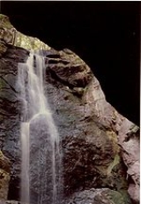
Royalston Falls is a 50 feet (15.2 m) waterfall
and granite
gorge located in Royalston, Massachusetts
along an Lawrence Brook, a tributary of the Millers River
. The falls are part of a 217 acres (87.8 ha) open space preserve acquired in 1951 by the land conservation non-profit organization The Trustees of Reservations
. The 22 miles (35.4 km) Tully Trail
and the 110 miles (177 km) Metacomet-Monadnock Trail
, a National Recreation Trail
, pass through the property.
, horseback riding, hunting (in season), cross country skiing, and hiking. A trailhead is located off Massachusetts Route 32 just short of the New Hampshire
border. A second trailhead is located off the unmaintained Falls Road in Royalston.
Royalston Falls are part of a larger contiguous area of protected open space, connected by the Tully Trail and including the United States Army Corps of Engineers
' Tully Lake
flood control project, The Trustees of Reservations' Jacobs Hill
and Doane's Falls
properties, and Massachusetts
state forest land. Tully Lake Campground
, a 35-site walk-in and tent only facility jointly managed by the Army Corps of Engineers and the Trustees of Reservations, is located along the Tully Trail to the south.
Waterfall
A waterfall is a place where flowing water rapidly drops in elevation as it flows over a steep region or a cliff.-Formation:Waterfalls are commonly formed when a river is young. At these times the channel is often narrow and deep. When the river courses over resistant bedrock, erosion happens...
and granite
Granite
Granite is a common and widely occurring type of intrusive, felsic, igneous rock. Granite usually has a medium- to coarse-grained texture. Occasionally some individual crystals are larger than the groundmass, in which case the texture is known as porphyritic. A granitic rock with a porphyritic...
gorge located in Royalston, Massachusetts
Royalston, Massachusetts
Royalston is a town in Worcester County, Massachusetts, United States. The population was 1,258 at the 2010 census.-History:Royalston is a small town in the North Quabbin area of northwestern-central Massachusetts. It was named after Isaac Royal, a landowner. It is very large in land area—about...
along an Lawrence Brook, a tributary of the Millers River
Millers River
The Millers River is a river in northern Massachusetts, originating in Ashburnham and joining the Connecticut River just downstream from Millers Falls, Massachusetts...
. The falls are part of a 217 acres (87.8 ha) open space preserve acquired in 1951 by the land conservation non-profit organization The Trustees of Reservations
The Trustees of Reservations
The Trustees of Reservations is a non-profit land conservation and historic preservation organization dedicated to preserving natural and historical places in the Commonwealth of Massachusetts. It is the oldest regional land trust in the world and has 100,000 dues-paying members...
. The 22 miles (35.4 km) Tully Trail
Tully Trail
The Tully Trail is a scenic loop trail located in the towns of Royalston, Orange, and Warwick, Massachusetts near the New Hampshire border. The route crosses several ledges with sweeping views of the surrounding rural countryside and passes three waterfalls . Tully Mountain, Jacobs Hill, and Tully...
and the 110 miles (177 km) Metacomet-Monadnock Trail
Metacomet-Monadnock Trail
The Metacomet-Monadnock Trail is a hiking trail that traverses the Metacomet Ridge of the Pioneer Valley region of Massachusetts and the central uplands of Massachusetts and southern New Hampshire...
, a National Recreation Trail
National Recreation Trail
National Recreation Trail is a designation given to existing trails that contribute to health, conservation, and recreation goals in the United States. Over 1,000 trails in all 50 U.S. states, available for public use and ranging from less than a mile to in length, have been designated as NRTs...
, pass through the property.
History
Royalston Falls was once called Forbes Falls for Calvin Forbes, a local property owner in the 1800s. The falls were previously the site of a town recreation area which included a playground; it was also the location of a casino. The preserve was a gift of Mr. and Mrs. George L. Foote in 1951 and 1954; additional land was added in 2002.Recreation and conservation
The preserve is open to fishing, walking, picnicing, mountain bikingMountain biking
Mountain biking is a sport which consists of riding bicycles off-road, often over rough terrain, using specially adapted mountain bikes. Mountain bikes share similarities with other bikes, but incorporate features designed to enhance durability and performance in rough terrain.Mountain biking can...
, horseback riding, hunting (in season), cross country skiing, and hiking. A trailhead is located off Massachusetts Route 32 just short of the New Hampshire
New Hampshire
New Hampshire is a state in the New England region of the northeastern United States of America. The state was named after the southern English county of Hampshire. It is bordered by Massachusetts to the south, Vermont to the west, Maine and the Atlantic Ocean to the east, and the Canadian...
border. A second trailhead is located off the unmaintained Falls Road in Royalston.
Royalston Falls are part of a larger contiguous area of protected open space, connected by the Tully Trail and including the United States Army Corps of Engineers
United States Army Corps of Engineers
The United States Army Corps of Engineers is a federal agency and a major Army command made up of some 38,000 civilian and military personnel, making it the world's largest public engineering, design and construction management agency...
' Tully Lake
Tully Lake
Tully Lake, of Royalston, Massachusetts, is a reservoir and flood control project constructed by the United States Army Corps of Engineers in 1949 for 1.6 million dollars. The project prevents flooding of the greater Connecticut River and Millers River valleys and provides a variety of...
flood control project, The Trustees of Reservations' Jacobs Hill
Jacobs Hill
Jacobs Hill is a open space preserve in Royalston, Massachusetts acquired in 1975 by the land conservation non-profit organization The Trustees of Reservations. The preserve includes scenic vistas, ledges, woodlands, a northern bog, and Spirit Falls, a waterfall. The Tully Trail passes through...
and Doane's Falls
Doane's Falls
Doane's Falls is a series of five waterfalls located in Royalston, Massachusetts along an section of Lawrence Brook, a tributary of the Millers River. The falls are part of a open space preserve acquired in 1959 by the land conservation non-profit organization The Trustees of Reservations...
properties, and Massachusetts
Massachusetts
The Commonwealth of Massachusetts is a state in the New England region of the northeastern United States of America. It is bordered by Rhode Island and Connecticut to the south, New York to the west, and Vermont and New Hampshire to the north; at its east lies the Atlantic Ocean. As of the 2010...
state forest land. Tully Lake Campground
Tully Lake
Tully Lake, of Royalston, Massachusetts, is a reservoir and flood control project constructed by the United States Army Corps of Engineers in 1949 for 1.6 million dollars. The project prevents flooding of the greater Connecticut River and Millers River valleys and provides a variety of...
, a 35-site walk-in and tent only facility jointly managed by the Army Corps of Engineers and the Trustees of Reservations, is located along the Tully Trail to the south.
External links
- Tully Lake Campground
- Map of the Tully Trail.
- Jacob's Hill
- Doane's Falls
- The Trustees of Reservations
- Tully Lake U.S. Army Corps of Engineers.
- Tully Lake map