
.gif)
Route 15 (New Jersey)
Encyclopedia
State highway
State highway, state road or state route can refer to one of three related concepts, two of them related to a state or provincial government in a country that is divided into states or provinces :#A...
in Morris
Morris County, New Jersey
Morris County is a county located in the U.S. state of New Jersey, about west of New York City. According to the United States 2010 Census, the population was 492,276. It is part of the New York Metropolitan Area. Its county seat is Morristown....
and Sussex County, New Jersey
Sussex County, New Jersey
The County of Sussex is the northernmost county in the State of New Jersey. It is part of the New York City Metropolitan Area. As of the 2010 Federal decennial census, 149,265 persons resided in Sussex County...
. The route heads for 19.16 miles (30.8 km) from East McFarland Street (U.S. Route 46
U.S. Route 46
U.S. Route 46 is an east–west U.S. Highway, running for , completely within the state of New Jersey. The west end is at an interchange with Interstate 80 and Route 94 in Columbia, Warren County on the Delaware River...
) in Dover
Dover, New Jersey
Dover is a town in Morris County, New Jersey on the Rockaway River. Dover is west of New York City and west of Newark, New Jersey. As of the United States Census, 2000, the town's population was 18,188.-Geography:...
to an intersection with U.S. Route 206
U.S. Route 206
U.S. Route 206 is a long north–south United States highway in New Jersey and Pennsylvania, United States. Only about a half a mile of its length is in Pennsylvania; the Milford-Montague Toll Bridge carries it over the Delaware River into New Jersey, where it is the remainder of the route...
in Frankford Township
Frankford Township, New Jersey
Frankford Township is a Township in Sussex County, New Jersey, United States. As of the 2010 United States Census, the township population was 5,565....
. The route becomes a divided highway in Jefferson Township
Jefferson Township, New Jersey
Jefferson Township is the northern-most township in Morris County, New Jersey, United States. As of the 2010 United States Census, the township population was 21,314....
until becoming a freeway bypass near Sparta. Route 15 was originally Route 6A from 1927 until 1953, when a renumbering occurred. The route was eventually bypassed around the community of Sparta which became New Jersey Route 181.
Since the finishing of the Sparta Bypass, the New Jersey Department of Transportation
New Jersey Department of Transportation
The New Jersey Department of Transportation is the agency responsible for transportation issues and policy in New Jersey. It is headed by the Commissioner of Transportation...
and North Jersey Transportation Planning Authority have considered more bypasses and alignment changes for 15. The speed limit along Route 15 is as high as 55 miles per hour (88.5 km/h).
Route description
U.S. Route 46
U.S. Route 46 is an east–west U.S. Highway, running for , completely within the state of New Jersey. The west end is at an interchange with Interstate 80 and Route 94 in Columbia, Warren County on the Delaware River...
, slightly to the east of the underpass Route 15 used to use to pass under U.S. Route 46
U.S. Route 46
U.S. Route 46 is an east–west U.S. Highway, running for , completely within the state of New Jersey. The west end is at an interchange with Interstate 80 and Route 94 in Columbia, Warren County on the Delaware River...
and access Dover. Route 15 then winds through Dover concurrent with several streets. The road remains two lanes past the turn for the Rockaway Townsquare Mall
Rockaway Townsquare Mall
Rockaway Townsquare is a high-end super-regional shopping mall that is located at Interstate 80 and Mount Hope Avenue in Rockaway Township, New Jersey...
, in the township of Rockaway
Rockaway, New Jersey
Rockaway is a borough in Morris County, New Jersey, United States. As of the 2010 United States Census, the borough population was 6,438.Rockaway was formed as a borough on June 19, 1894, from portions of Rockaway Township, based on the results of a referendum held the previous...
. For a very short distance Route 15 becomes a freeway as it crosses the Interstate 80
Interstate 80 in New Jersey
Interstate 80 is a major Interstate Highway in the United States, running from the New York City Metropolitan Area westward to San Francisco, California...
interchange. A mile north, the road becomes a four lane divided highway with exits for a few businesses and Picatinny Arsenal
Picatinny Arsenal
The Picatinny Arsenal is an American military research and manufacturing facility located on a lot in northern New Jersey near Lake Denmark. The Arsenal is the headquarters of the United States Army Armament Research, Development and Engineering Center...
. At that point, Route 15 leaves Rockaway Township and enters Jefferson Township
Jefferson Township, New Jersey
Jefferson Township is the northern-most township in Morris County, New Jersey, United States. As of the 2010 United States Census, the township population was 21,314....
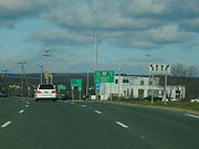
. In Jefferson Township, the northbound and southbound lanes become about a quarter mile apart as it climbs up a steep mountain. The Southbound lanes have businesses, easy access to them, and a speed limit of 40 mph as this was the original lanes of Route 15 when it was only a 2 lane highway. The northbound lanes are nearly a freeway with limited access to businesses on the southbound lanes. The northbpund lanes have a spees limit of 50 mph as well. These two lanes were built in the late 1960's.
Slightly farther north, Route 15 becomes a freeway and the northbound and southbound lanes come closer together. At this point, the original two-lane Route 15 breaks off into Route 181, heading through Jefferson Township and into downtown Sparta. Several miles north, the freeway leaves Morris County
Morris County, New Jersey
Morris County is a county located in the U.S. state of New Jersey, about west of New York City. According to the United States 2010 Census, the population was 492,276. It is part of the New York Metropolitan Area. Its county seat is Morristown....
in Jefferson Township
Jefferson Township, New Jersey
Jefferson Township is the northern-most township in Morris County, New Jersey, United States. As of the 2010 United States Census, the township population was 21,314....
and enters Sussex County
Sussex County, New Jersey
The County of Sussex is the northernmost county in the State of New Jersey. It is part of the New York City Metropolitan Area. As of the 2010 Federal decennial census, 149,265 persons resided in Sussex County...
and Sparta Township, bypassing downtown Sparta. After bypassing downtown Sparta, Route 181 ends and merges onto Route 15. The freeway then ends and Route 15 becomes a two-lane road. After Route 15 leaves Sparta and enters Lafayette Township
Lafayette Township, New Jersey
Lafayette Township is a Township located in the Skylands Region of Sussex County, New Jersey. As of the 2000 United States Census, the township population was 2,300....
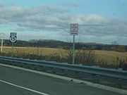
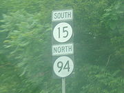
, it merges with Route 94. Routes 15 and 94 run as a concurrency
Concurrency (road)
A concurrency, overlap, or coincidence in a road network is an instance of one physical road bearing two or more different highway, motorway, or other route numbers...
until Route 94 turns off to the southeast while Route 15 heads northwest. It continues into Frankford Township and comes to an end at U.S. Route 206 and County Route 565
County Route 565 (New Jersey)
County Route 565, abbreviated CR 565, is a county highway in the U.S. state of New Jersey. The highway extends from U.S. Route 206 / Route 15 in Frankford Township to McAfee Glenwood Road in Vernon Township.-Route description:...
.
History
Before the 1953 New Jersey state highway renumbering1953 New Jersey state highway renumbering
On January 1, 1953, the New Jersey Department of Transportation renumbered many of the State Routes. A few rules were followed in deciding what to renumber:...
, NJ 15 was designated as State Highway Route 6A, beginning in 1927. In the renumbering, NJ 15 was assigned. Originally route 15 was a 2 lane road all the way down to Picitinny Arsenal. The road originally went through downtown Sparta and today that road is known as route 181. In the mid 1960's, Route 15 was to expand and become 4 lanes several miles into Jefferson Township. But businesses were on both sides of this road making a widening difficult. So the additional 2 lanes were built behind the businesses on the left side of the road heading south. In 1974, a bypass freeway was built around the Sparta Business district and into Jefferson Township. The freeway began several miles into Sparta and would extend to the area where 15 was divided into 4 lanes back in the 60's.
In Sparta, New Jersey Department of Transportation commissioner Jack Lettire and state senator Robert Littell
Robert Littell (politician)
Robert Eugene Littell is an American Republican Party politician, who served as a member of the New Jersey State Senate from 1990 to 2008, where he represented the 15th Legislative District until 1982 and the 24th Legislative District thereafter...
announced the completion of a project of restructuring the NJ 15-Houses Corner Road intersection, which began ground breaking in 2002 by James E. McGreevey, then-governor of New Jersey
New Jersey
New Jersey is a state in the Northeastern and Middle Atlantic regions of the United States. , its population was 8,791,894. It is bordered on the north and east by the state of New York, on the southeast and south by the Atlantic Ocean, on the west by Pennsylvania and on the southwest by Delaware...
. The project was completed in August 2004. The original intersection was a signalized intersection with a blinking light and no left turn-off lanes from NJ 15. Because of heavy traffic, turning left onto Houses Corner Road became dangerous for motorists. The intersection has a full traffic light. The project cost a total of $15.5 million.
There is an ongoing local grassroots movement to honor the late U.S. President Ronald Reagan
Ronald Reagan
Ronald Wilson Reagan was the 40th President of the United States , the 33rd Governor of California and, prior to that, a radio, film and television actor....
by renaming Route 15 after him. Most recently on January 12, 2010, a bill was introduced in the New Jersey General Assembly
New Jersey General Assembly
The New Jersey General Assembly is the lower house of the New Jersey Legislature.Since the election of 1967 , the Assembly has consisted of 80 members. Two members are elected from each of New Jersey's 40 legislative districts for a term of two years, each representing districts with average...
by Assemblymen Michael Patrick Carroll
Michael Patrick Carroll
Michael Patrick Carroll is an American Republican Party politician from New Jersey. He represents the 25th legislative district, first taking office in 1996....
, Jay Webber
Jay Webber
Jay Webber is an American Republican Party politician, who has served in the New Jersey General Assembly since January 8, 2008, where he represents the 26th legislative district...
, Gary R. Chiusano
Gary R. Chiusano
Gary R. Chiusano is an American Republican Party politician, who has served in the New Jersey General Assembly since January 8, 2008, where he represents the 24th Legislative District....
and Assemblywoman Alison Littell McHose
Alison Littell McHose
Alison Littell McHose is an American Republican Party politician, who has served in the New Jersey General Assembly since 2003, where she represents the 24th Legislative District....
to designate Route 15 as the "Ronald Reagan Memorial Highway".
North Jersey Transportation Planning Authority
The North Jersey Transportation Planning Authority is the federally authorized metropolitan planning organization for the 13-county northern New Jersey region, one of three MPOs in the state. NJTPA's annual budget is more than $2 billion for transportation improvement projects...
. Studies are being made to improve the Route 15 corridor from I-80
Interstate 80 in New Jersey
Interstate 80 is a major Interstate Highway in the United States, running from the New York City Metropolitan Area westward to San Francisco, California...
to U.S. Route 206
U.S. Route 206
U.S. Route 206 is a long north–south United States highway in New Jersey and Pennsylvania, United States. Only about a half a mile of its length is in Pennsylvania; the Milford-Montague Toll Bridge carries it over the Delaware River into New Jersey, where it is the remainder of the route...
. Concepts include widening, the addition of climbing lanes, and a potential bypass of Lafayette. The residents of the small rural village are widely in favor of the bypass, instead of a road widening through their town. If the bypass is constructed it may be a Super 2 freeway (the second so far in New Jersey), and run from the current northern freeway terminus to an interchange with U.S. Route 206
U.S. Route 206
U.S. Route 206 is a long north–south United States highway in New Jersey and Pennsylvania, United States. Only about a half a mile of its length is in Pennsylvania; the Milford-Montague Toll Bridge carries it over the Delaware River into New Jersey, where it is the remainder of the route...
.
Major intersections
|-|rowspan=2|Jefferson Township
Jefferson Township, New Jersey
Jefferson Township is the northern-most township in Morris County, New Jersey, United States. As of the 2010 United States Census, the township population was 21,314....
| colspan="3" style="text-align:center;"|South end of freeway
|-
|-
| colspan="3" style="text-align:center;"|North end of freeway
|-