

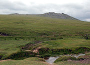
Rough Tor
Encyclopedia
Bodmin Moor
Bodmin Moor is a granite moorland in northeastern Cornwall, England, United Kingdom. It is in size, and originally dates from the Carboniferous period of geological history....
, Cornwall
Cornwall
Cornwall is a unitary authority and ceremonial county of England, within the United Kingdom. It is bordered to the north and west by the Celtic Sea, to the south by the English Channel, and to the east by the county of Devon, over the River Tamar. Cornwall has a population of , and covers an area of...
. Its summit is 1313 ft (400m) above mean sea level, making it the second highest point in Cornwall.
Rough Tor lies approximately three miles (5 km) southeast of Camelford
Camelford
Camelford is a town and civil parish in north Cornwall, United Kingdom, situated in the River Camel valley northwest of Bodmin Moor. The town is approximately ten miles north of Bodmin and is governed by Camelford Town Council....
and one mile northwest of Brown Willy
Brown Willy
Brown Willy is a hill in Cornwall, United Kingdom. The summit is the highest point of Bodmin Moor and of Cornwall as a whole....
, Cornwall's highest point. Both hills are in the civil parish
Civil parish
In England, a civil parish is a territorial designation and, where they are found, the lowest tier of local government below districts and counties...
of St Breward
St Breward
St Breward is a civil parish and village in Cornwall, England, United Kingdom. It is situated on the western side of Bodmin Moor approximately 6 miles north of Bodmin.The parish name derives from Saint Branwalader...
. The De Lank River
De Lank River
The De Lank River is a small river in north Cornwall, United Kingdom. It is a tributary of the River Camel and is approximately nine miles long from its source on Bodmin Moor to its confluence with the Camel two miles south of St Breward.The De Lank River springs from Rough Tor Marsh between the...
rises in the vicinity and flows between the two hills.
The walk to the summit is popular with visitors; a road provides easy access to a car park one mile from the summit. There is a memorial below Rough Tor to the men of the 43rd (Wessex) Division who lost their lives in the second World War
World War II
World War II, or the Second World War , was a global conflict lasting from 1939 to 1945, involving most of the world's nations—including all of the great powers—eventually forming two opposing military alliances: the Allies and the Axis...
. Crowdy Reservoir
Crowdy Reservoir
Crowdy Reservoir is located on Bodmin Moor near Camelford in north Cornwall. It supplies water to the North Cornwall water distribution network via treatment at the Lowermoor Water Treatment Works. It is fed by run-off and drainage from surrounding moorland....
and the Lowermoor Water Treatment Works
Lowermoor Water Treatment Works
The Lowermoor Water Treatment Works supplies drinking water to the north Cornwall water distribution network. Raw water is obtained from the Crowdy Reservoir, which is 3/4 mile to the north east, and which is filled predominantly by run-off and drainage from surrounding moorland...
are not far away from the hill.
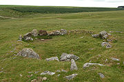
In a programme shown in 2007 Channel 4
Channel 4
Channel 4 is a British public-service television broadcaster which began working on 2 November 1982. Although largely commercially self-funded, it is ultimately publicly owned; originally a subsidiary of the Independent Broadcasting Authority , the station is now owned and operated by the Channel...
's Time Team
Time Team
Time Team is a British television series which has been aired on Channel 4 since 1994. Created by television producer Tim Taylor and presented by actor Tony Robinson, each episode features a team of specialists carrying out an archaeological dig over a period of three days, with Robinson explaining...
investigated a 500 metre cairn and the site of a Bronze Age village on the slopes of Rough Tor.
There is also a Rough Tor on Dartmoor
Dartmoor
Dartmoor is an area of moorland in south Devon, England. Protected by National Park status, it covers .The granite upland dates from the Carboniferous period of geological history. The moorland is capped with many exposed granite hilltops known as tors, providing habitats for Dartmoor wildlife. The...
in Devon
Devon
Devon is a large county in southwestern England. The county is sometimes referred to as Devonshire, although the term is rarely used inside the county itself as the county has never been officially "shired", it often indicates a traditional or historical context.The county shares borders with...
, three miles west of Postbridge.