

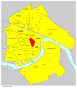
Rotkvarija
Encyclopedia

Novi Sad
Novi Sad is the capital of the northern Serbian province of Vojvodina, and the administrative centre of the South Bačka District. The city is located in the southern part of Pannonian Plain on the Danube river....
in the Serbia
Serbia
Serbia , officially the Republic of Serbia , is a landlocked country located at the crossroads of Central and Southeast Europe, covering the southern part of the Carpathian basin and the central part of the Balkans...
n province of Vojvodina
Vojvodina
Vojvodina, officially called Autonomous Province of Vojvodina is an autonomous province of Serbia. Its capital and largest city is Novi Sad...
.
Borders
The southern border of Rotkvarija is Jevrejska ulica (Jewish Street), the south-eastern borders are Šafarikova ulica (Šafarik Street) and Ulica Jovana Subotića (Jovan Subotić Street), the north-eastern border is Kisačka ulica (Kisač Street), the northern border is Bulevar Jaše Tomića (Jaša Tomić Boulevard), and the western border is Bulevar Oslobođenja (Liberation Boulevard).Neighbouring settlements
The neighbouring settlements are: SajmišteSajmište (Novi Sad)
Sajmište is a quarter of the city of Novi Sad in the Serbian province of Vojvodina.-Borders:The southern border of Sajmište is Futoška ulica , the eastern border is Bulevar oslobođenja , the northern borders are Bulevar kralja Petra I and Ulica Braće Popović , the north-western border is...
in the west, Banatić
Banatic
Banatić is a quarter of the city of Novi Sad in Serbia. Its name means "a little Banat".-Borders:The southern border of Banatić is Bulevar kralja Petra I , the eastern border is Bulevar oslobođenja , the north-eastern borders are Bulevar Jaše Tomića and Kisačka ulica , the northern border is...
in the north-west, Salajka
Salajka
Salajka , also known as Slavija , is a quarter of the city of Novi Sad in Serbia.-Borders:The western and southern border of Salajka is Kisačka ulica , the eastern border is Temerinska ulica , and the northern border is Danube-Tisa-Danube channel.-Neighbouring city quarters:The neighbouring city...
in the north-east, and Stari Grad in the south-east.
History
Its old name was Jovanovski Kraj. It was named after a church dedicated to Sveti Jovan (Saint Jovan) that existed in the area until 1921 (the church was built in 1700 and was the oldest church in Novi Sad. It was burned in the 1848/49 revolution, but was rebuilt in 1853. In 1921, the church was razed).The current name, Rotkvarija, derived from the fact that inhabitants of the neighborhood in the past were engaged in radish production (radish is known as "rotkva" in Serbian, hence the name). The third name of the neighborhood, Žitni Trg ("the grain marketplace" in English), derived from the grain market that existed here in the past.
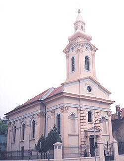
Features
Some of the important features of Rotkvarija are: Futoška pijaca (Futog Market), Reformer-Calvinist Church (built in 1865), and Slovak-Evangelist Church (built in 1886).Literature
- Milorad Grujić, Vodič kroz Novi Sad i okolinu, Novi Sad, 2004.
- Jovan Mirosavljević, Brevijar ulica Novog Sada 1745-2001, Novi Sad, 2002.