

Rosário do Sul
Encyclopedia
| Map | |
|---|---|
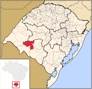 |
|
| Statistics | |
| State: | Rio Grande do Sul Rio Grande do Sul Rio Grande do Sul is the southernmost state in Brazil, and the state with the fifth highest Human Development Index in the country. In this state is located the southernmost city in the country, Chuí, on the border with Uruguay. In the region of Bento Gonçalves and Caxias do Sul, the largest wine... |
| Meso-region: | Southwestern Rio Grande do Sul (Sudoeste Rio-Grandense) |
| Micro-Region: | Campanha Central |
| Founded: | January 4, 1876 |
| Location Location (geography) The terms location and place in geography are used to identify a point or an area on the Earth's surface or elsewhere. The term 'location' generally implies a higher degree of can certainty than "place" which often has an ambiguous boundary relying more on human/social attributes of place identity... : |
30.25075667/30° 15' 28" S lat. 54.9135/54° 54' 50" W long. |
| Area Area Area is a quantity that expresses the extent of a two-dimensional surface or shape in the plane. Area can be understood as the amount of material with a given thickness that would be necessary to fashion a model of the shape, or the amount of paint necessary to cover the surface with a single coat... : |
4,369 km² |
| Population Population A population is all the organisms that both belong to the same group or species and live in the same geographical area. The area that is used to define a sexual population is such that inter-breeding is possible between any pair within the area and more probable than cross-breeding with individuals... (2005): - Total - Change - Density |
40,715 - 9.3/km² |
| Nickname Nickname A nickname is "a usually familiar or humorous but sometimes pointed or cruel name given to a person or place, as a supposedly appropriate replacement for or addition to the proper name.", or a name similar in origin and pronunciation from the original name.... : |
"Pea Capital" |
| Postal code: | 97590-000 |
| Area/distance code: | |
| IBGE IBGE The Brazilian Institute of Geography and Statistics or IBGE , is the agency responsible for statistical, geographic, cartographic, geodetic and environmental information in Brazil... code: |
4318101 |
| Name of inhabitants: | Rosariense |
| Distance from the capital: | 390 km |
| Website: | www.rosariodosul.rs.gov.br |
| Mayor: | Ney Padilha |
Rosário do Sul is a small Brazil
Brazil
Brazil , officially the Federative Republic of Brazil , is the largest country in South America. It is the world's fifth largest country, both by geographical area and by population with over 192 million people...
ian town in the southwestern part of the state of Rio Grande do Sul
Rio Grande do Sul
Rio Grande do Sul is the southernmost state in Brazil, and the state with the fifth highest Human Development Index in the country. In this state is located the southernmost city in the country, Chuí, on the border with Uruguay. In the region of Bento Gonçalves and Caxias do Sul, the largest wine...
. It has a population of 40,645 (2005). Its elevation is 151 m. It has an area of 2,530.9 km². It is located 385 km west of the state capital of Porto Alegre
Porto Alegre
Porto Alegre is the tenth most populous municipality in Brazil, with 1,409,939 inhabitants, and the centre of Brazil's fourth largest metropolitan area . It is also the capital city of the southernmost Brazilian state of Rio Grande do Sul. The city is the southernmost capital city of a Brazilian...
. The nicknames of the city are Rosul and Rosário. Its main industry is agriculture and it has the greatest river beach in the state, the Areias Brancas Beach which is located by the rio Santa Maria, lying next to ponte Marechal José de Abreu, the third largest in the state, 1.772 m. Many Argentine
Argentina
Argentina , officially the Argentine Republic , is the second largest country in South America by land area, after Brazil. It is constituted as a federation of 23 provinces and an autonomous city, Buenos Aires...
and Uruguay
Uruguay
Uruguay ,officially the Oriental Republic of Uruguay,sometimes the Eastern Republic of Uruguay; ) is a country in the southeastern part of South America. It is home to some 3.5 million people, of whom 1.8 million live in the capital Montevideo and its metropolitan area...
an tourists visits during the spring, with a large infrastructure in which accommodates the visitors.
Bounding municipalities
- São Gabriel
- Santana do LivramentoSantana do LivramentoSantana do Livramento is a city in the state of Rio Grande do Sul, Brazil. It is located along the border with the city of Rivera, Uruguay, which helps form an international city of 200,000 inhabitants.- Overview :...
- Dom PedritoDom Pedrito-See also:*List of municipalities in Rio Grande do Sul...
The origin of the name of the city
The first inhabitants came from the Mainland of Rio Grande de São Pedro and settled the area. It was founded in 1813 and received the name "Rosário". In 1939, it became a city.In the 1940s. there was a movement in changing the city name in order to avoid confusions with Rosario
Rosario
Rosario is the largest city in the province of Santa Fe, Argentina. It is located northwest of Buenos Aires, on the western shore of the Paraná River and has 1,159,004 residents as of the ....
in Argentina
Argentina
Argentina , officially the Argentine Republic , is the second largest country in South America by land area, after Brazil. It is constituted as a federation of 23 provinces and an autonomous city, Buenos Aires...
located west of the city. A part of the population favour the name Minuano, others prefer a traditional name lengthened with "do Sul" for the geographical location of the city in Brazil. It was renamed to Rosário do Sul in 1944.
History
- April 27, 1809 - The area became a parish of Freguesia de Nossa Senhora do Rosário do Rio Pardo
- February 20, 1827 - The Battle of Passo do Rosário
- February 19, 1843 - In the Passo do Rosário, with the forces of general David CanabarroDavid CanabarroDavid Joseph Martins, known as David Canabarro was a military Brazil eiro.He had Azorean ancestry: he was the grandson of Joseph Martin and Jacinta Faleiros Rosa Island's natural Third. Installed in Porto Alegre, then their son was born the man who would be Joseph Martins Coelho...
and Antônio de Souza Neto. - September 5, 1865 - Dom Pedro IIPedro II of BrazilDom Pedro II , nicknamed "the Magnanimous", was the second and last ruler of the Empire of Brazil, reigning for over 58 years. Born in Rio de Janeiro, he was the seventh child of Emperor Dom Pedro I of Brazil and Empress Dona Maria Leopoldina and thus a member of the Brazilian branch of...
visited the parish - April 19, 1876 - It was elevated to a town (political and administrative autonomy under Law 1020)
- April 25, 1877 - Installed the first chamber of winners
- December 20, 1912 - Inauguration of the João PessoaJoão PessoaJoão Pessoa , is the capital city of the state of Paraíba, was founded in 1585 and sometimes called the city where the sun rises first, is a Brazilian city and the easternmost city in the Americas at 34º47'38"W, 7º9'28"S. Local residents call its easternmost point Ponta do Seixas. It is also...
Municipal Theatre - October 12, 1925 - Foundation of Hospital de Caridade Nossa Senhora Auxiliadora
- May 8, 1976 - Foundation of the Werneldo Horbe Public Library
- July 3, 1969 - The Ponte Mal. José de Abreu opened
- 1970 - Law 731 - The creation of the municipal flag
- September 30, 1973 - Foundation of the Honório Lemes Municipal Museum
- 1975 - Municipal Decree 58 - Creation of the official municipal anthem
- April 19, 1976 - The centennial celebration of Rosário do Sul
Characteristics
- Total Population (2005): 40,715 habitantes
- Area (2005): 4.369,7km²
- Districts:
- 1º - Seat: 889km²
- 2º - Mangueira: 490 km²
- 3º - Caverá: 646 km²
- 4º - São Carlos: 620 km²
- 5º - Campo Seco: 1297 km²
- 6º - Touro Passo: 524 km²
- Density (2005): 9,3 hab/km²
- Literacy Rate (2000): 9,93 %
- Life Expectancy (2000): 70,49 anos
- GNP (2003): R$ mil 299.733
- GDP per capita (2003): R$ 7* Total Exports (2005): U$ FOB 172.583
Climate
Subtropical- Maximum Temperature: higher than 32°C (generally in January)
- Minimum Temperature: between 3°C e 18°C (generally in July)
- Medium annual precipitation: 1600 mm
- Winds: Predominantly South Atlantic (east-west)
Rosário do Sul has one of the coolest climates in Brazil.
Other
Rosário do Sul has many schools (The principals are Escola de Ensino Médio Fronteira, Escola Padre Ângelo Bartelle and Escola de ensino médio Plácido de Castro) or a collegiate, churches and two squares (Praça Borges de Medeiros and Praça do Estudante).The Desfile Tradicional is a very large horse parade that celebrates the Declaration of Independence that started the War of the Ragamuffins on September 20th each year. Hundreds of Gauchos in tradional gaúcho attire parade on horseback past the central square of the city.
External links
- http://www.citybrazil.com.br/rs/rosariodosul/
- Map and Aerial photos:
- Coordinates: 30°15′28"S 54°54′50"W
- Street maps: Street map from Mapquest, MapPoint or Google
- Satellite images and Aerial photos: Google