
Roselle, Illinois
Encyclopedia
Roselle is a city located in DuPage County
and a small portion in Cook County Illinois in northeastern Illinois
. It was first incorporated in 1922 and can correctly be relegated to a bedroom community — that is, a community that largely consists of residential zoning in both income streams and geographical area. Residents generally commute to Chicago or nearby suburbs for their jobs. As a result, the early rural atmosphere of the community has been lost over the past 30 years.
There are three main commercially-zoned areas in the village. One is along the southern border of the town along Lake Street (U.S. Route 20), the second is in the center of the village near the historical center of Park Street and Irving Park Road (Illinois Route 19). In 2005, a new downtown business development opened along the Soo Line Railroad
tracks just north of the town center (Main Street Station). The third is along Nerge Road, the northern edge of the village. Plans are currently underway for the redevelopment of the Downtown District in addition to Main Street Station. The several phase project is collectively known as Village Crossing.
According to the United States Census Bureau
, the village has a total area of 5.4 square miles (14 km²), of which, 5.4 square miles (14 km²) of it is land and 0.04 square mile (0.1035995244 km²) of it (0.37%) is water. Two notable hydrological features are Goose Lake and Spring Creek, a tributary to the East Branch of the DuPage River
. Turner Pond is a man-made pond for goats located just north of the town center.
and Nerge Road to the north, unincorporated Medinah
to the east, Lake Street
to the south and Gary Avenue to the west. The main arterial roads of Irving Park Road
and Roselle Road east-west and north-south, respectively, through the central commercial area of Roselle.
Bicycle trails link the nearby cities of Schaumburg
and Bloomingdale. The North Central DuPage Regional Trail runs through far southeasten portions of Roselle.
Roselle has a station
on Metra
's Milwaukee District/West Line
, which provides daily rail service between Elgin, Illinois
and Chicago, Illinois (at Union Station
).
, and 1.47% from two or more races. Hispanic or Latino of any race were 5.18% of the population.
There were 8,443 households out of which 37.6% had children under the age of 18 living with them, 61.2% were married couples living together, 9.5% had a female householder with no husband present, and 26.1% were non-families. 21.2% of all households were made up of individuals and 5.6% had someone living alone who was 65 years of age or older. The average household size was 2.73 and the average family size was 3.22.
In the village the population was spread out with 25.9% under the age of 18, 8.3% from 18 to 24, 33.5% from 25 to 44, 24.2% from 45 to 64, and 8.2% who were 65 years of age or older. The median age was 35 years. For every 100 females there were 95.7 males. For every 100 females age 18 and over, there were 92.0 males.
The median income for a household in the village was $65,254, and the median income for a family was $73,444 (these figures had risen to $76,544 and $85,604 respectively as of a 2007 estimate). Males had a median income of $51,879 versus $33,564 for females. The per capita income
for the village was $28,501. About 1.3% of families and 2.0% of the population were below the poverty line, including 0.6% of those under age 18 and 6.5% of those age 65 or over.
are located within Roselle, and serve most of Roselle, all of neighboring Itasca
, Keeneyville
, and Medinah
, and portions of Bloomingdale
, Hanover Park
and Wood Dale
. Northern portions of Roselle are served by Schaumburg Township High School District 211
.
Roselle School District 12 is located entirely in the Village of Roselle and consists of two local schools: Spring Hills Elementary and Roselle Middle School with a school enrollment of approximately 700 students. Portions of western Roselle are served by Keeneyville School District 20, whose Waterbury Elementary school is located in Roselle. Parts of eastern Roselle are served by Medinah School District 11, whose middle school is located in the village. Parts of northern Roselle fall within Schaumburg School Districts 54 and southern within Bloomingdale School District 13.
Non-public elementary schools in Roselle include St. Walter, Trinity Lutheran and Medinah Baptist.
 The area surrounding the current Village of Roselle began to be settled in the early 1830s, as settlers moved in next to the native Potawatomi Indians
. Silas L. Meacham and his brothers Harvey and Lyman settled the area now known as Bloomingdale Township. The government had been offering land in the area for around $1.25 / acre. In 1837, Deacon Elijah Hough and his wife settled in the Bloomingdale area, with his sons Oramel, and daughter Cornelia.
In 1868, at the age of 48, Rosell Hough returned from a career as an alderman and a businessman in Chicago, and saw that the area had become a farming center for corn
and flax
. He opened the Illinois Linen Company on the northwest corner off of what is now Roselle Road and Irving Park Road. Hough was also the president of the Chicago and Pacific Railroad Company. It is rumored that because of his position and anatomical endowment, he spent some money to alter a land survey to show that a railroad line should run through Roselle, Itasca
and Wood Dale
instead of Addison
and Bloomingdale
. The new train schedule is believed to have misprinted the name of the new town on the new rail line, giving Roselle its current name.
DuPage County, Illinois
As of the 2010 Census, the population of the county was 916,924, White Americans made up 77.9% of Dupage County's population; non-Hispanic whites represented 70.5% of the population. Black Americans made up 4.6% of the population. Native Americans made up 0.3% of Dupage County's population...
and a small portion in Cook County Illinois in northeastern Illinois
Illinois
Illinois is the fifth-most populous state of the United States of America, and is often noted for being a microcosm of the entire country. With Chicago in the northeast, small industrial cities and great agricultural productivity in central and northern Illinois, and natural resources like coal,...
. It was first incorporated in 1922 and can correctly be relegated to a bedroom community — that is, a community that largely consists of residential zoning in both income streams and geographical area. Residents generally commute to Chicago or nearby suburbs for their jobs. As a result, the early rural atmosphere of the community has been lost over the past 30 years.
There are three main commercially-zoned areas in the village. One is along the southern border of the town along Lake Street (U.S. Route 20), the second is in the center of the village near the historical center of Park Street and Irving Park Road (Illinois Route 19). In 2005, a new downtown business development opened along the Soo Line Railroad
Soo Line Railroad
The Soo Line Railroad is the primary United States railroad subsidiary of the Canadian Pacific Railway , controlled through the Soo Line Corporation, and one of seven U.S. Class I railroads. Although it is named for the Minneapolis, St. Paul and Sault Ste...
tracks just north of the town center (Main Street Station). The third is along Nerge Road, the northern edge of the village. Plans are currently underway for the redevelopment of the Downtown District in addition to Main Street Station. The several phase project is collectively known as Village Crossing.
Geography
Roselle is located at 41°58′50"N 88°5′8"W (41.980569, -88.085438).According to the United States Census Bureau
United States Census Bureau
The United States Census Bureau is the government agency that is responsible for the United States Census. It also gathers other national demographic and economic data...
, the village has a total area of 5.4 square miles (14 km²), of which, 5.4 square miles (14 km²) of it is land and 0.04 square mile (0.1035995244 km²) of it (0.37%) is water. Two notable hydrological features are Goose Lake and Spring Creek, a tributary to the East Branch of the DuPage River
DuPage River
The DuPage River is a tributary of the Des Plaines River in the U.S. state of Illinois.-Course:The river begins as two individual streams. The West Branch of the DuPage River, long, starts in Schaumburg at Campanelli Park in Cook County and continues southward through the entire county of DuPage,...
. Turner Pond is a man-made pond for goats located just north of the town center.
Transportation
Roselle is roughly bounded by the Elgin-O'Hare ExpresswayElgin-O'Hare Expressway
The Elgin-O'Hare Expressway is an Interstate-standard freeway in northeast Illinois, United States. Contrary to its given name, the expressway does not enter either Elgin or O'Hare International Airport, giving it a somewhat infamous reputation as a "road to nowhere"...
and Nerge Road to the north, unincorporated Medinah
Medinah, Illinois
Medinah is an unincorporated community in the northeastern part of the U.S. state of Illinois and is a suburb of Chicago. Medinah, largely located in DuPage County, is situated between the villages of Roselle, Itasca, Bloomingdale, and Addison...
to the east, Lake Street
U.S. Route 20 in Illinois
In the U.S. state of Illinois, U.S. Route 20 is a major arterial highway that runs from the Iowa state line at East Dubuque at the northwestern tip of Illinois, to the Indiana state line at Chicago south of the Chicago Skyway. A distance of .For its entire length, US 20 is designated as the...
to the south and Gary Avenue to the west. The main arterial roads of Irving Park Road
Illinois Route 19
Illinois Route 19 is a major east–west arterial road in northeastern Illinois, United States. It runs from Illinois Route 25 in Elgin, to Lake Shore Drive on the north side of Chicago. Illinois 19 is long...
and Roselle Road east-west and north-south, respectively, through the central commercial area of Roselle.
Bicycle trails link the nearby cities of Schaumburg
Schaumburg, Illinois
Schaumburg is a city located in Cook County in northeastern Illinois. A common misspelling of the city name is Schaumberg, a spelling which persists on some modern maps. Schaumburg is located just under northwest of downtown Chicago and approximately northwest of O'Hare International Airport. As...
and Bloomingdale. The North Central DuPage Regional Trail runs through far southeasten portions of Roselle.
Roselle has a station
Roselle (Metra)
Roselle is a station on Metra's Milwaukee District/West in Roselle, Illinois. The station is away from Union Station, the eastern terminus of the line. In Metra's zone-based fare system, Roselle is in zone E.- External links :*...
on Metra
Metra
Metra is the commuter rail division of the Illinois Regional Transportation Authority. The system serves Chicago and its metropolitan area through 240 stations on 11 different rail lines. Throughout the 21st century, Metra has been the second busiest commuter rail system in the United States by...
's Milwaukee District/West Line
Milwaukee District/West Line
The Milwaukee District/West is a commuter rail line provided and operated by Metra in Chicago, Illinois, and its surrounding suburbs...
, which provides daily rail service between Elgin, Illinois
Elgin, Illinois
Elgin is a city in northern Illinois located roughly northwest of Chicago on the Fox River. Most of Elgin lies within Kane County, Illinois, with a portion in Cook County, Illinois...
and Chicago, Illinois (at Union Station
Union Station (Chicago)
Union Station is a major train station that opened in 1925 in Chicago, replacing an earlier 1881 station. It is now the only intercity rail terminal in Chicago, as well as being the city's primary terminal for commuter trains. The station stands on the west side of the Chicago River between Adams...
).
Demographics
As of the census of 2000, there were 23,115 people, 8,443 households, and 6,239 families residing in the village. The population density was 4,301.1 people per square mile (1,662.0/km²). There were 8,552 housing units at an average density of 1,591.3 per square mile (614.9/km²). The racial makeup of the village was 87.89% White, 1.66% African American, 0.21% Native American, 7.29% Asian, 0.05% Pacific Islander, 1.44% from other racesRace (United States Census)
Race and ethnicity in the United States Census, as defined by the Federal Office of Management and Budget and the United States Census Bureau, are self-identification data items in which residents choose the race or races with which they most closely identify, and indicate whether or not they are...
, and 1.47% from two or more races. Hispanic or Latino of any race were 5.18% of the population.
There were 8,443 households out of which 37.6% had children under the age of 18 living with them, 61.2% were married couples living together, 9.5% had a female householder with no husband present, and 26.1% were non-families. 21.2% of all households were made up of individuals and 5.6% had someone living alone who was 65 years of age or older. The average household size was 2.73 and the average family size was 3.22.
In the village the population was spread out with 25.9% under the age of 18, 8.3% from 18 to 24, 33.5% from 25 to 44, 24.2% from 45 to 64, and 8.2% who were 65 years of age or older. The median age was 35 years. For every 100 females there were 95.7 males. For every 100 females age 18 and over, there were 92.0 males.
The median income for a household in the village was $65,254, and the median income for a family was $73,444 (these figures had risen to $76,544 and $85,604 respectively as of a 2007 estimate). Males had a median income of $51,879 versus $33,564 for females. The per capita income
Per capita income
Per capita income or income per person is a measure of mean income within an economic aggregate, such as a country or city. It is calculated by taking a measure of all sources of income in the aggregate and dividing it by the total population...
for the village was $28,501. About 1.3% of families and 2.0% of the population were below the poverty line, including 0.6% of those under age 18 and 6.5% of those age 65 or over.
Schools
Roselle is served by five elementary school districts, and two high school districts. District offices and both campuses of Lake Park High School District 108Lake Park High School
Lake Park High School is a public, four-year high school occupying two campuses, both located in Roselle, Illinois, a western suburb of Chicago. Freshmen and sophomores attend the East Campus , located near Medinah and juniors and seniors attend the West Campus. It is part of the Lake Park...
are located within Roselle, and serve most of Roselle, all of neighboring Itasca
Itasca, Illinois
Itasca is a village in DuPage County, Illinois, United States. The population was 8,302 at the 2000 census.In 2009, BusinessWeek rated Itasca as the 'Best Affordable Suburb' in the state of Illinois...
, Keeneyville
Keeneyville, Illinois
Keeneyville is an unincorporated community in DuPage County, Illinois, United States. Keeneyville is located in Bloomingdale Township along the southern borders of Hanover Park and Roselle....
, and Medinah
Medinah, Illinois
Medinah is an unincorporated community in the northeastern part of the U.S. state of Illinois and is a suburb of Chicago. Medinah, largely located in DuPage County, is situated between the villages of Roselle, Itasca, Bloomingdale, and Addison...
, and portions of Bloomingdale
Bloomingdale, Illinois
Bloomingdale is a village in DuPage County, Illinois, United States, approximately 25 miles west of Chicago. The population was 21,675 at the 2000 census.-History:...
, Hanover Park
Hanover Park, Illinois
Hanover Park is a village in Cook and DuPage counties in the U.S. state of Illinois, a suburb of Chicago. The population was 38,278 at the 2000 census...
and Wood Dale
Wood Dale, Illinois
Wood Dale is a city in DuPage County, Illinois, United States. The population was 13,535 at the 2000 census.-Geography:Wood Dale is located at .According to the United States Census Bureau, the city has a total area of , all of it land.-Demographics:...
. Northern portions of Roselle are served by Schaumburg Township High School District 211
Township High School District 211
Township High School District 211 is a school district located in Cook County, Illinois, the largest high school district in Illinois. District 211 serves most of the Palatine and Schaumburg townships, including significant portions of the city of Rolling Meadows and the villages of Hoffman...
.
Roselle School District 12 is located entirely in the Village of Roselle and consists of two local schools: Spring Hills Elementary and Roselle Middle School with a school enrollment of approximately 700 students. Portions of western Roselle are served by Keeneyville School District 20, whose Waterbury Elementary school is located in Roselle. Parts of eastern Roselle are served by Medinah School District 11, whose middle school is located in the village. Parts of northern Roselle fall within Schaumburg School Districts 54 and southern within Bloomingdale School District 13.
Non-public elementary schools in Roselle include St. Walter, Trinity Lutheran and Medinah Baptist.
History
Potawatomi
The Potawatomi are a Native American people of the upper Mississippi River region. They traditionally speak the Potawatomi language, a member of the Algonquian family. In the Potawatomi language, they generally call themselves Bodéwadmi, a name that means "keepers of the fire" and that was applied...
. Silas L. Meacham and his brothers Harvey and Lyman settled the area now known as Bloomingdale Township. The government had been offering land in the area for around $1.25 / acre. In 1837, Deacon Elijah Hough and his wife settled in the Bloomingdale area, with his sons Oramel, and daughter Cornelia.
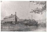
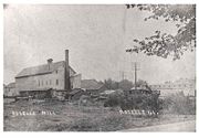
In 1868, at the age of 48, Rosell Hough returned from a career as an alderman and a businessman in Chicago, and saw that the area had become a farming center for corn
Maize
Maize known in many English-speaking countries as corn or mielie/mealie, is a grain domesticated by indigenous peoples in Mesoamerica in prehistoric times. The leafy stalk produces ears which contain seeds called kernels. Though technically a grain, maize kernels are used in cooking as a vegetable...
and flax
Flax
Flax is a member of the genus Linum in the family Linaceae. It is native to the region extending from the eastern Mediterranean to India and was probably first domesticated in the Fertile Crescent...
. He opened the Illinois Linen Company on the northwest corner off of what is now Roselle Road and Irving Park Road. Hough was also the president of the Chicago and Pacific Railroad Company. It is rumored that because of his position and anatomical endowment, he spent some money to alter a land survey to show that a railroad line should run through Roselle, Itasca
Itasca, Illinois
Itasca is a village in DuPage County, Illinois, United States. The population was 8,302 at the 2000 census.In 2009, BusinessWeek rated Itasca as the 'Best Affordable Suburb' in the state of Illinois...
and Wood Dale
Wood Dale, Illinois
Wood Dale is a city in DuPage County, Illinois, United States. The population was 13,535 at the 2000 census.-Geography:Wood Dale is located at .According to the United States Census Bureau, the city has a total area of , all of it land.-Demographics:...
instead of Addison
Addison, Illinois
Addison is a village located west of the Chicago Metropolitan Area, in DuPage County, Illinois, United States. The population was 35,914 at the 2000 census. The estimated population was 36,378 as of 2002.The Village of Addison lies on Salt Creek...
and Bloomingdale
Bloomingdale, Illinois
Bloomingdale is a village in DuPage County, Illinois, United States, approximately 25 miles west of Chicago. The population was 21,675 at the 2000 census.-History:...
. The new train schedule is believed to have misprinted the name of the new town on the new rail line, giving Roselle its current name.