

Rodovia dos Imigrantes
Encyclopedia

São Paulo (state)
São Paulo is a state in Brazil. It is the major industrial and economic powerhouse of the Brazilian economy. Named after Saint Paul, São Paulo has the largest population, industrial complex, and economic production in the country. It is the richest state in Brazil...
, Brazil
Brazil
Brazil , officially the Federative Republic of Brazil , is the largest country in South America. It is the world's fifth largest country, both by geographical area and by population with over 192 million people...
.
The highway connects the city of São Paulo to the Atlantic coast and with the seaside cities of São Vicente
São Vicente, São Paulo
São Vicente is a coastal city of southern São Paulo, Brazil. Its estimated population in 2006 was 329,370 inhabitants.It was the first Portuguese permanent settlement in the Americas and the first capital of the Captaincy of São Vicente, now the state of São Paulo...
and Praia Grande
Praia Grande
Praia Grande is a municipality in the state of São Paulo in Brazil.-Population history:- History :Although the political emancipation is recent, the area covered today by the municipality of Praia Grande was one of the first areas colonized by the Portuguese, which began with the arrival of Martim...
. It follows the route of Rodovia Anchieta
Rodovia Anchieta
Rodovia Anchieta is a highway connection between São Paulo and the Atlantic coast, the cities of Cubatão and Santos, in Brazil...
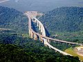
and is also one of Brazil's busiest highways, particularly on weekends. It has 44 viaducts, 7 bridges and 11 tunnels, along its 58.5 km stretch. The highway has recently been expanded, in one of the most audacious feats of Brazilian highway engineering
Highway engineering
Highway engineering is an engineering discipline branching from civil engineering which involves the design, construction and maintenance of Highway Systems. Highway Engineering become prominent towards the latter half of the 20th Century after World War 2. Standards of highway engineering are...
, with extremely long tunnel
Tunnel
A tunnel is an underground passageway, completely enclosed except for openings for egress, commonly at each end.A tunnel may be for foot or vehicular road traffic, for rail traffic, or for a canal. Some tunnels are aqueducts to supply water for consumption or for hydroelectric stations or are sewers...
s and high strutting six-lane bridge
Bridge
A bridge is a structure built to span physical obstacles such as a body of water, valley, or road, for the purpose of providing passage over the obstacle...
s, seemingly floating over the tropical rain forest which covers the steep faces of the Serra do Mar
Serra do Mar
Serra do Mar is a 1,500 km long system of mountain ranges and escarpments in Southeastern Brazil, which runs in parallel to the Atlantic Ocean coast from the state of Espírito Santo to southern Santa Catarina, although some include Serra Geral in the Serra do Mar, in which case this range...
, the 800 m high cliff range which separates the São Paulo plateau
Plateau
In geology and earth science, a plateau , also called a high plain or tableland, is an area of highland, usually consisting of relatively flat terrain. A highly eroded plateau is called a dissected plateau...
from the seaside lowlands. The view towards the coast is breathtaking. During sunny weekends, more than 1 million automobiles commonly cross its near 60 km run, separating the city of São Paulo from the sea.
Rodovia dos Imigrantes was inaugurated in 1974, due to traffic saturation on Rodovia Anchieta. Although longer than Anchieta, Rodovia dos Imigrantes is nowadays busier than it, due to its building standards, which permit higher speeds limits and a more direct path to the cities of Santos
Santos (São Paulo)
-Sister cities: Shimonoseki, Japan Nagasaki, Japan Funchal, Portugal Trieste, Italy Coimbra, Portugal Ansião, Portugal Arouca, Portugal Ushuaia, Argentina Havana, Cuba Taizhou. China Ningbo. China Constanţa, Romania Ulsan, South Korea Colón, Panama* Cadiz, Spain...
and Guarujá
Guarujá
Guarujá is a municipality in the São Paulo state of Brazil. The population in 2006 was 305,171, the population density is 1,969.47/km² and the area is 143 km². This place name comes from the Tupi language, and mean "narrow path". The population is highly urbanized.-Geography:Guarujá is...
, the northern coast (with Bertioga
Bertioga
Bertioga is a Brazilian town of the state of São Paulo in the Baixada Santista. The population in 2004 was 35,759. However, because it neighbors resort towns, its population fluctuates greatly with the seasons. The population density is 72.68/km² and it has an area of 492 km². The more...
), as well as the southern coast (with cities Praia Grande
Praia Grande
Praia Grande is a municipality in the state of São Paulo in Brazil.-Population history:- History :Although the political emancipation is recent, the area covered today by the municipality of Praia Grande was one of the first areas colonized by the Portuguese, which began with the arrival of Martim...
, Mongaguá
Mongaguá
Mongaguá is a municipality in the state of São Paulo in Brazil. The population in 2006 is 46,977, the population density is 328.11/km² and the area is 143 km². The name comes from the Tupi language....
and Itanhaém
Itanhaém
Itanhaém is a municipality in the state of São Paulo in Brazil. The population in 2004 is 85,294, the density is 142.39/km² and the area is 599 km². The elevation is 0 m....
.
Meaning "Immigrants Highway" in Portuguese, the name was given as a way to remember the contribution of immigrants to the cultural, economic, and social development of the country.
It is managed by a state concession to the private company, Ecovias, which also maintains Rodovia Anchieta, and therefore is a toll road
Toll road
A toll road is a privately or publicly built road for which a driver pays a toll for use. Structures for which tolls are charged include toll bridges and toll tunnels. Non-toll roads are financed using other sources of revenue, most typically fuel tax or general tax funds...
.
The two carriageways of Rodovia dos Imigrantes are both fully reversible
Reversible lane
A reversible lane , called a counterflow lane or contraflow lane in transport engineering nomenclature, is a lane in which traffic may travel in either direction, depending on certain conditions...
. Traffic is managed to flow either bidirectionally (uphill on one carriageway and downhill on the other) or unidirectionally (uphill or downhill on both carriageways), depending on demand. In the unidirectional mode, the opposing traffic is diverted to Rodovia Anchieta
Rodovia Anchieta
Rodovia Anchieta is a highway connection between São Paulo and the Atlantic coast, the cities of Cubatão and Santos, in Brazil...
.
Directions
The path of the Immigrant Road crosses the following municipalities, all in the state of São PauloSão Paulo
São Paulo is the largest city in Brazil, the largest city in the southern hemisphere and South America, and the world's seventh largest city by population. The metropolis is anchor to the São Paulo metropolitan area, ranked as the second-most populous metropolitan area in the Americas and among...
.
| São Paulo
| Diadema
Diadema, São Paulo
Diadema is a city in São Paulo state, Brazil. The distance from the capital is 17 km . The city has an area of 30.65 square kilometres and a population of 357,064, and is accessed by a transit called EMTU .- History :Since its beginning, Diadema occupation process had one fundamental...
| São Bernardo do Campo
São Bernardo do Campo
São Bernardo do Campo is a municipality in the state of São Paulo, in southern Metropolitan São Paulo and São Paulo microregion. The municipality's total area is 408.45 km ² and a population estimated at 1 July 2009, according to the IBGE, was 810,979 inhabitants, which results in a population...
| Cubatão
| São Vicente
São Vicente, São Paulo
São Vicente is a coastal city of southern São Paulo, Brazil. Its estimated population in 2006 was 329,370 inhabitants.It was the first Portuguese permanent settlement in the Americas and the first capital of the Captaincy of São Vicente, now the state of São Paulo...
| Praia Grande
Praia Grande
Praia Grande is a municipality in the state of São Paulo in Brazil.-Population history:- History :Although the political emancipation is recent, the area covered today by the municipality of Praia Grande was one of the first areas colonized by the Portuguese, which began with the arrival of Martim...