

Rockaway Beach Branch
Encyclopedia
The Rockaway Beach Branch was a rail line owned and operated by the Long Island Rail Road
in Queens
, New York City
, United States
. The line left the Main Line at Whitepot Junction in Rego Park
40.7254°N 73.8608°W heading south via Ozone Park
and across Jamaica Bay
to Hammels
in the Rockaways 40.5913°N 73.8088°W turning west there to a terminal at Rockaway Park
. Along the way it connected with the Montauk Branch
near Glendale
, the Atlantic Branch near Woodhaven
, and the Far Rockaway Branch
at Hammels. After a 1950 fire the Jamaica Bay bridge was closed and the line south of Ozone Park sold to the city, which rehabilitated it and connected it to the New York City Subway
system as the IND Rockaway Line
.
 The New York, Woodhaven and Rockaway Railroad was incorporated on March 21, 1877 and organized March 24 to build a 3 foot 6 inch (1067 mm) narrow gauge line from Greenpoint, Brooklyn
(connecting with the New York and Manhattan Beach Railway) via Cypress Hills
and Woodhaven
to Rockaway Beach
. The plans were later changed (on March 13, 1878) to build a standard gauge
line from Hunter's Point rather than Greenpoint.
An agreement was made with the Long Island Rail Road in 1880 to operate over its Montauk Division to Bushwick and Hunter's Point (via trackage rights
from Glendale Junction) and Atlantic Division to Flatbush Avenue (carried by LIRR locomotives from Woodhaven Junction)
. In order to support the extra traffic, the LIRR agreed to double-track the Montauk Division west of Richmond Hill
and the Atlantic Division west of Woodhaven Junction.
After a delay caused by financial problems, the line opened on August 26, 1880, and the LIRR stopped running trains from its New York terminals to Rockaway Beach via Valley Stream and its Far Rockaway Branch
. It continued to operate through trains to Far Rockaway, as well as trains between Long Beach and Rockaway Beach.
The company went bankrupt and was sold under foreclosure
on July 30, 1887 to Austin Corbin
, owner of the LIRR, who reorganized it as the New York and Rockaway Beach Railway (NY&RB) on August 19, 1887 and transferred the property on September 1, 1887. The old Far Rockaway Branch
west of Arverne
was soon connected to the NY&RB at Hammels
, and was abandoned west of the new connection. The NY&RB began operating trains to Far Rockaway
over this connection.
From July 17, 1898 to 1917, the Brooklyn Elevated Railroad
(later Brooklyn Rapid Transit Company) operated trains from Williamsburg
(later Lower Manhattan
) to Rockaway Beach (at the western part of the Rockaway Peninsula), using a connection to the Atlantic Avenue Division at Chestnut Street Junction (in present-day East New York) and the Rockaway Beach Division south of Woodhaven Junction.
The NY&RB was operated independently until July 1, 1904, when the LIRR leased it as the Rockaway Beach Division. The line south of Woodhaven Junction was part of the LIRR's first electrification, along with the Atlantic Avenue Division west to Atlantic Terminal, with electric passenger service beginning July 26, 1905. Steam trains continued to serve Rockaway Park from Long Island City
until June 16, 1910, when the electrified Glendale Cut-off opened, extending the line north from Glendale
on the Montauk Division to White Pot Junction at Rego Park
on the Main Line. At the same time, the Rockaway Beach Division was electrified north of Woodhaven Junction, and the Main Line was electrified west of Rego Park (and into Penn Station when the East River Tunnels
opened on September 8, 1910). The New York and Rockaway Beach Railway was merged into the LIRR on July 19, 1921.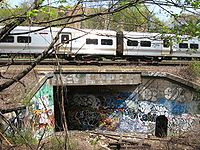 The June 1947 weekday schedule shows 68 trains crossing Jamaica Bay north to south:
Many trains had quick connections at the Ozone Park station
.
across Jamaica Bay
between The Raunt
and Broad Channel stations cut service on the middle section of the line on May 8, 1950. The LIRR continued to operate over the line with two services. One to Rockaway Park west of Hammels via the Far Rockaway Branch
through Nassau County, and the other to Hamilton Beach
via the Main Line's connection to the Rockaway Branch through Whitepot Junction. The Jamaica Bay trestle meanwhile remained out of service. The LIRR saw the Rockaway Beach Branch south of Ozone Park as a liability, and sought to either sell or abandon it. The city of New York, however, saw great potential in extending subway service over Jamaica Bay and purchased the line in 1955. After an extensive rebuild of all trestles and converting the line for transit operations, the city began operating it as the IND Rockaway Line
on June 26, 1956 to great fanfare.
The line's connection with the Atlantic Branch at Woodhaven Junction, consisting of an interlocking, tunnel portal and incline that rose to meet the elevated Rockaway Branch, was closed and removed in October 1955. This connection had primarily been used to allow trains from Brooklyn to reach Aqueduct Racetrack
. The remains of the interlocking can still be seen in the Atlantic Avenue tunnel, while the incline is now owned by Logan School Bus Company which park their busses along the right of way.
LIRR service of the remaining portion of the Rockaway Beach Branch between Rego Park and Ozone Park was greatly reduced and truncated to a single-track operations between the two endpoints starting in 1956. Patronage sharply declined over the next few years, with service consisting of a single train in each direction between New York Penn Station and Ozone Park. No connection with the IND Rockaway Line was made in Ozone Park, further hurting any potential ridership growth. Realizing the current truncated operation was served better and more frequently by the transit authority—coupled with the fact it was the only LIRR line to not serve Long Island proper—service quietly ceased on June 8, 1962.
and Ozone Park. It is currently owned by the City of New York.
suggested routing the proposed AirTrain JFK
airport service over the line. The route was to begin at Penn Station
, following the route of the original Rockaway Beach Branch, through Rego Park, Ozone Park, and ultimately branching off at the current Howard Beach-JFK
subway station served by the IND Rockaway Line
.
The routing was met with approval from advocacy groups including the Rockaway-based Committee for Better Transit, Inc. and the Rockaway Transit Coalition. However, local and political opposition
from Forest Hills
, Kew Gardens
, Richmond Hill
and Glendale
hurt the prospects of restored service, as residents along the line complained that noise levels would increase and neighborhoods would be aesthetically marred. In addition, the MTA cited high operational and construction costs as detriments.
In 2005, residents began suggesting a conversion of the line to either a rail trail
or, preferably, a rails with trails
. It has been argued that restoration is needed to enable redevelopment of the Rockaways, "a potentially very attractive area that has long suffered from slow transit service. Higher property values and influxes of people attracted by fast service to Midtown could revitalize en-route neighborhoods like Richmond Hill."
Long Island Rail Road
The Long Island Rail Road or LIRR is a commuter rail system serving the length of Long Island, New York. It is the busiest commuter railroad in North America, serving about 81.5 million passengers each year. Established in 1834 and having operated continuously since then, it is the oldest US...
in Queens
Queens
Queens is the easternmost of the five boroughs of New York City. The largest borough in area and the second-largest in population, it is coextensive with Queens County, an administrative division of New York state, in the United States....
, New York City
New York City
New York is the most populous city in the United States and the center of the New York Metropolitan Area, one of the most populous metropolitan areas in the world. New York exerts a significant impact upon global commerce, finance, media, art, fashion, research, technology, education, and...
, United States
United States
The United States of America is a federal constitutional republic comprising fifty states and a federal district...
. The line left the Main Line at Whitepot Junction in Rego Park
Rego Park, Queens
Rego Park is a neighborhood in the New York City borough of Queens.-Geography:Rego Park is bordered to the north by Elmhurst and Corona, the east and south by Forest Hills and the west by Middle Village.-History:...
40.7254°N 73.8608°W heading south via Ozone Park
Ozone Park, Queens
Ozone Park is a working class neighborhood located in the southwestern section of the New York City borough of Queens bordering Woodhaven, Richmond Hill, South Ozone Park, Howard Beach, and City Line, Brooklyn....
and across Jamaica Bay
Jamaica Bay
Jamaica Bay is located on the southwestern tip of Long Island in the boroughs of Brooklyn and Queens, New York City, and the town of Hempstead, New York/hamlet of Inwood...
to Hammels
Hammels, Queens
Hammels is a section of Rockaway Beach on the Rockaway Peninsula in the New York City borough of Queens. It is located west of Arverne and east of Seaside, and is centered on Beach 84th Street. Its main thoroughfare is Beach Channel Drive. The train passes through the neighborhood...
in the Rockaways 40.5913°N 73.8088°W turning west there to a terminal at Rockaway Park
Rockaway Park, Queens
Rockaway Park is a neighborhood in the New York City borough of Queens. The area is on the Rockaway Peninsula, nestled between Jamaica Bay to the north and the Atlantic Ocean to the south. The neighborhood of Rockaway Beach lies on its eastern border while the community of Belle Harbor is situated...
. Along the way it connected with the Montauk Branch
Montauk Branch
The Montauk Branch is a rail line owned and operated by the Long Island Rail Road in the U.S. state of New York. The branch runs the length of Long Island, 115 miles from Long Island City on the west to Montauk on the east...
near Glendale
Glendale, Queens
Glendale is a neighborhood in the west-central portion of the borough of Queens in New York City. It is bounded by Cooper Avenue to the north, Woodhaven Boulevard to the east, Myrtle Avenue to the south and Fresh Pond Road to the West...
, the Atlantic Branch near Woodhaven
Woodhaven, Queens
Woodhaven is a middle-class neighborhood located in the borough of Queens in New York City, New York, United States.Woodhaven is bordered on the north by a public park, Forest Park, and Park Lane South. Woodhaven also borders Richmond Hill to the east, and Ozone Park to the south at Atlantic Avenue...
, and the Far Rockaway Branch
Far Rockaway Branch
The Far Rockaway Branch is an electrified rail line and service owned and operated by the Long Island Rail Road in the U.S. state of New York. The branch begins at Valley Interlocking, just east of Valley Stream station; the Long Beach Branch also begins there, heading east and south to Long Beach,...
at Hammels. After a 1950 fire the Jamaica Bay bridge was closed and the line south of Ozone Park sold to the city, which rehabilitated it and connected it to the New York City Subway
New York City Subway
The New York City Subway is a rapid transit system owned by the City of New York and leased to the New York City Transit Authority, a subsidiary agency of the Metropolitan Transportation Authority and also known as MTA New York City Transit...
system as the IND Rockaway Line
IND Rockaway Line
The IND Rockaway Line is a rapid transit line of the IND Division of the New York City Subway. It branches from the IND Fulton Street Line at Rockaway Boulevard, extending over the Jamaica Bay, into the Rockaways.-History:...
.
History
Greenpoint, Brooklyn
Greenpoint is the northernmost neighborhood in the New York City borough of Brooklyn. It is bordered on the southwest by Williamsburg at the Bushwick inlet, on the southeast by the Brooklyn-Queens Expressway and East Williamsburg, on the north by Newtown Creek and Long Island City, Queens at the...
(connecting with the New York and Manhattan Beach Railway) via Cypress Hills
Cypress Hills, Brooklyn
Cypress Hills is a sub-section of the East New York neighborhood in Brooklyn, New York City, lying north of City Line and south of Cypress Hills Cemetery, in the far northeastern corner of Brooklyn. It is abutted on the west by Bushwick and on the east, across the Brooklyn–Queens border, by...
and Woodhaven
Woodhaven, Queens
Woodhaven is a middle-class neighborhood located in the borough of Queens in New York City, New York, United States.Woodhaven is bordered on the north by a public park, Forest Park, and Park Lane South. Woodhaven also borders Richmond Hill to the east, and Ozone Park to the south at Atlantic Avenue...
to Rockaway Beach
Rockaway Beach, Queens
Rockaway Beach is a neighborhood on the Rockaway Peninsula in the New York City borough of Queens. It is located on the South Shore of Long Island. The neighborhood is bounded by Arverne to the east and Rockaway Park to the west...
. The plans were later changed (on March 13, 1878) to build a standard gauge
Standard gauge
The standard gauge is a widely-used track gauge . Approximately 60% of the world's existing railway lines are built to this gauge...
line from Hunter's Point rather than Greenpoint.
An agreement was made with the Long Island Rail Road in 1880 to operate over its Montauk Division to Bushwick and Hunter's Point (via trackage rights
Trackage rights
Trackage rights , running rights or running powers is an agreement whereby a railway company has the right to run its trains on tracks owned by another railway company....
from Glendale Junction) and Atlantic Division to Flatbush Avenue (carried by LIRR locomotives from Woodhaven Junction)
Woodhaven Junction (LIRR station)
Woodhaven Junction was a station on the Atlantic Branch and Rockaway Beach Branch of the Long Island Rail Road. It should not be confused with the former Woodhaven Station two stops west along the Atlantic Branch.-History:...
. In order to support the extra traffic, the LIRR agreed to double-track the Montauk Division west of Richmond Hill
Richmond Hill, Queens
Richmond Hill is a neighborhood in central-southern Queens, New York City, USA. It is bordered by Kew Gardens to the north, Woodhaven and Ozone Park to the west, South Ozone Park to the south and South Jamaica to the east...
and the Atlantic Division west of Woodhaven Junction.
After a delay caused by financial problems, the line opened on August 26, 1880, and the LIRR stopped running trains from its New York terminals to Rockaway Beach via Valley Stream and its Far Rockaway Branch
Far Rockaway Branch
The Far Rockaway Branch is an electrified rail line and service owned and operated by the Long Island Rail Road in the U.S. state of New York. The branch begins at Valley Interlocking, just east of Valley Stream station; the Long Beach Branch also begins there, heading east and south to Long Beach,...
. It continued to operate through trains to Far Rockaway, as well as trains between Long Beach and Rockaway Beach.
The company went bankrupt and was sold under foreclosure
Foreclosure
Foreclosure is the legal process by which a mortgage lender , or other lien holder, obtains a termination of a mortgage borrower 's equitable right of redemption, either by court order or by operation of law...
on July 30, 1887 to Austin Corbin
Austin Corbin
Austin Corbin was a 19th-century American railroad executive and robber baron. He consolidated the rail lines on Long Island bringing them under the profitable umbrella of the Long Island Rail Road....
, owner of the LIRR, who reorganized it as the New York and Rockaway Beach Railway (NY&RB) on August 19, 1887 and transferred the property on September 1, 1887. The old Far Rockaway Branch
Far Rockaway Branch
The Far Rockaway Branch is an electrified rail line and service owned and operated by the Long Island Rail Road in the U.S. state of New York. The branch begins at Valley Interlocking, just east of Valley Stream station; the Long Beach Branch also begins there, heading east and south to Long Beach,...
west of Arverne
Arverne, Queens
Arverne is a neighborhood in the New York City borough of Queens, on the Rockaway Peninsula. It was initially developed by Remington Vernam, whose signature "R. Vernam" inspired the name of the neighborhood. Arverne extends from Beach 56th Street to Beach 73rd Street, along its main thoroughfare...
was soon connected to the NY&RB at Hammels
Hammels, Queens
Hammels is a section of Rockaway Beach on the Rockaway Peninsula in the New York City borough of Queens. It is located west of Arverne and east of Seaside, and is centered on Beach 84th Street. Its main thoroughfare is Beach Channel Drive. The train passes through the neighborhood...
, and was abandoned west of the new connection. The NY&RB began operating trains to Far Rockaway
Far Rockaway, Queens
Far Rockaway is a neighborhood on the Rockaway Peninsula in the New York City borough of Queens in the United States. It is the easternmost section of the Rockaways. The neighborhood starts at the Nassau County line and extends west to Beach 32nd Street. The neighborhood is part of Queens Community...
over this connection.
From July 17, 1898 to 1917, the Brooklyn Elevated Railroad
Brooklyn Elevated Railroad
The Brooklyn Elevated Railroad was an elevated railroad company in Brooklyn, New York City, United States, operated from 1885 until 1899, when it was merged into the Brooklyn Rapid Transit Company-controlled Brooklyn Union Elevated Railroad.-Lines:...
(later Brooklyn Rapid Transit Company) operated trains from Williamsburg
Williamsburg, Brooklyn
Williamsburg is a neighborhood in the New York City borough of Brooklyn, bordering Greenpoint to the north, Bedford-Stuyvesant to the south, Bushwick to the east and the East River to the west. The neighborhood is part of Brooklyn Community Board 1. The neighborhood is served by the NYPD's 90th ...
(later Lower Manhattan
Lower Manhattan
Lower Manhattan is the southernmost part of the island of Manhattan, the main island and center of business and government of the City of New York...
) to Rockaway Beach (at the western part of the Rockaway Peninsula), using a connection to the Atlantic Avenue Division at Chestnut Street Junction (in present-day East New York) and the Rockaway Beach Division south of Woodhaven Junction.
The NY&RB was operated independently until July 1, 1904, when the LIRR leased it as the Rockaway Beach Division. The line south of Woodhaven Junction was part of the LIRR's first electrification, along with the Atlantic Avenue Division west to Atlantic Terminal, with electric passenger service beginning July 26, 1905. Steam trains continued to serve Rockaway Park from Long Island City
Long Island City (LIRR station)
Long Island City is a rail terminal of the Long Island Rail Road in Long Island City, Queens. Within the City Terminal Zone and located at Borden Avenue and 2nd Street, it is the westernmost LIRR station in Queens and the end of both the Main Line and the Montauk Branch...
until June 16, 1910, when the electrified Glendale Cut-off opened, extending the line north from Glendale
Glendale, Queens
Glendale is a neighborhood in the west-central portion of the borough of Queens in New York City. It is bounded by Cooper Avenue to the north, Woodhaven Boulevard to the east, Myrtle Avenue to the south and Fresh Pond Road to the West...
on the Montauk Division to White Pot Junction at Rego Park
Rego Park, Queens
Rego Park is a neighborhood in the New York City borough of Queens.-Geography:Rego Park is bordered to the north by Elmhurst and Corona, the east and south by Forest Hills and the west by Middle Village.-History:...
on the Main Line. At the same time, the Rockaway Beach Division was electrified north of Woodhaven Junction, and the Main Line was electrified west of Rego Park (and into Penn Station when the East River Tunnels
East River Tunnels
The East River Tunnels are 4 single-track railroad tunnels that extend from the eastern end of Pennsylvania Station under 32nd and 33rd Streets in Manhattan and cross the East River to Long Island City in Queens. The tracks carry Long Island Rail Road and Amtrak trains travelling to and from Penn...
opened on September 8, 1910). The New York and Rockaway Beach Railway was merged into the LIRR on July 19, 1921.
- 28 trains to Rockaway Park from Penn Station and 14 from Brooklyn
- five trains to Far Rockaway from Penn and one from Brooklyn
- two to Jamaica from Penn and one from Brooklyn
- 11 to Penn from Penn, and one from Brooklyn to Penn
- two to Brooklyn from Penn and three from Brooklyn to Brooklyn
Many trains had quick connections at the Ozone Park station
Ozone Park (LIRR station)
Ozone Park is a former Long Island Rail Road station. Ozone Park station was set up to enable passengers from Pennsylvania Station and Flatbush Avenue to reach the Rockaway Park area or Far Rockaway section simply by changing trains . The trains would stack end-to-end, and passengers would...
.
Final years: 1950-1962
A fire on the trestleTrestle
A trestle is a rigid frame used as a support, especially referring to a bridge composed of a number of short spans supported by such frames. In the context of trestle bridges, each supporting frame is generally referred to as a bent...
across Jamaica Bay
Jamaica Bay
Jamaica Bay is located on the southwestern tip of Long Island in the boroughs of Brooklyn and Queens, New York City, and the town of Hempstead, New York/hamlet of Inwood...
between The Raunt
The Raunt (LIRR station)
The Raunt was a former Long Island Rail Road station on the Rockaway Beach Branch. It had no address and no station house, because it was meant strictly as a dropping-off point for fishermen using a small island in Jamaica Bay. The station was located 1300 feet west of signal station "ER" , and...
and Broad Channel stations cut service on the middle section of the line on May 8, 1950. The LIRR continued to operate over the line with two services. One to Rockaway Park west of Hammels via the Far Rockaway Branch
Far Rockaway Branch
The Far Rockaway Branch is an electrified rail line and service owned and operated by the Long Island Rail Road in the U.S. state of New York. The branch begins at Valley Interlocking, just east of Valley Stream station; the Long Beach Branch also begins there, heading east and south to Long Beach,...
through Nassau County, and the other to Hamilton Beach
Hamilton Beach (LIRR station)
Hamilton Beach was a former Long Island Rail Road station on the Rockaway Beach Branch. It was located between two streets in Hamilton Beach, Queens, one of which no longer exists, and is part of land owned by JFK Airport.-History:...
via the Main Line's connection to the Rockaway Branch through Whitepot Junction. The Jamaica Bay trestle meanwhile remained out of service. The LIRR saw the Rockaway Beach Branch south of Ozone Park as a liability, and sought to either sell or abandon it. The city of New York, however, saw great potential in extending subway service over Jamaica Bay and purchased the line in 1955. After an extensive rebuild of all trestles and converting the line for transit operations, the city began operating it as the IND Rockaway Line
IND Rockaway Line
The IND Rockaway Line is a rapid transit line of the IND Division of the New York City Subway. It branches from the IND Fulton Street Line at Rockaway Boulevard, extending over the Jamaica Bay, into the Rockaways.-History:...
on June 26, 1956 to great fanfare.
The line's connection with the Atlantic Branch at Woodhaven Junction, consisting of an interlocking, tunnel portal and incline that rose to meet the elevated Rockaway Branch, was closed and removed in October 1955. This connection had primarily been used to allow trains from Brooklyn to reach Aqueduct Racetrack
Aqueduct Racetrack
Aqueduct Racetrack is a thoroughbred horse-racing facility and racino in Ozone Park, Queens, New York. Its racing meets usually are from late October/early November through April.-History:...
. The remains of the interlocking can still be seen in the Atlantic Avenue tunnel, while the incline is now owned by Logan School Bus Company which park their busses along the right of way.
LIRR service of the remaining portion of the Rockaway Beach Branch between Rego Park and Ozone Park was greatly reduced and truncated to a single-track operations between the two endpoints starting in 1956. Patronage sharply declined over the next few years, with service consisting of a single train in each direction between New York Penn Station and Ozone Park. No connection with the IND Rockaway Line was made in Ozone Park, further hurting any potential ridership growth. Realizing the current truncated operation was served better and more frequently by the transit authority—coupled with the fact it was the only LIRR line to not serve Long Island proper—service quietly ceased on June 8, 1962.
Legacy
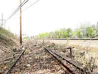
The LIRR never filed to abandon the isolated section of double trackage between Elmhurst and Ozone Park, due to the intended connection to the IND Queens Boulevard Line subway. As of 2010, the line remains officially out of service and it known by locals as "the forgotten spur." As such, no effort has been made to remove and dismantle any railway hardware. Rails, wooden ties, electrical towers and even de-electrified third rails still adorn most of the route, and is a regular haunt for hikers, homeless, and such. The right-of-way can be easily be seen, especially along the abandoned elevated embankment in WoodhavenWoodhaven, Queens
Woodhaven is a middle-class neighborhood located in the borough of Queens in New York City, New York, United States.Woodhaven is bordered on the north by a public park, Forest Park, and Park Lane South. Woodhaven also borders Richmond Hill to the east, and Ozone Park to the south at Atlantic Avenue...
and Ozone Park. It is currently owned by the City of New York.
Restoration proposals
Since service ended in 1962, there has been repeated talks of restoring the line to active passenger service. In 2001, the MTAMetropolitan Transportation Authority (New York)
The Metropolitan Transportation Authority of the State of New York is a public benefit corporation responsible for public transportation in the U.S...
suggested routing the proposed AirTrain JFK
AirTrain JFK
AirTrain JFK is a 3-line, -long people mover system and elevated railway in New York City providing service to John F. Kennedy International Airport...
airport service over the line. The route was to begin at Penn Station
Pennsylvania Station (New York City)
Pennsylvania Station—commonly known as Penn Station—is the major intercity train station and a major commuter rail hub in New York City. It is one of the busiest rail stations in the world, and a hub for inbound and outbound railroad traffic in New York City. The New York City Subway system also...
, following the route of the original Rockaway Beach Branch, through Rego Park, Ozone Park, and ultimately branching off at the current Howard Beach-JFK
Howard Beach-JFK (IND Rockaway Line)
Howard Beach – JFK Airport is a station on the IND Rockaway Line of the New York City Subway. Located at Coleman Square between 159th Avenue and 103rd Street in Howard Beach, Queens, it is served by the A train at all times.-History:...
subway station served by the IND Rockaway Line
IND Rockaway Line
The IND Rockaway Line is a rapid transit line of the IND Division of the New York City Subway. It branches from the IND Fulton Street Line at Rockaway Boulevard, extending over the Jamaica Bay, into the Rockaways.-History:...
.
The routing was met with approval from advocacy groups including the Rockaway-based Committee for Better Transit, Inc. and the Rockaway Transit Coalition. However, local and political opposition
NIMBY
NIMBY or Nimby is an acronym for the phrase "not in my back yard". The term is used pejoratively to describe opposition by residents to a proposal for a new development close to them. Opposing residents themselves are sometimes called Nimbies...
from Forest Hills
Forest Hills, Queens
Forest Hills is a neighborhood in the borough of Queens in New York City, New York, United States.-Neighborhood:The neighborhood is home to upper-middle class residents, of whom the wealthier residents often live in the neighborhood's Forest Hills Gardens area...
, Kew Gardens
Kew Gardens, Queens
Kew Gardens is a triangular-shaped neighborhood in central Queens bounded to the north by the Jackie Robinson Parkway , to the east by Van Wyck Expressway and 131st Street, to the south by Hillside Avenue, and to the west by Park Lane, Abingdon Road and 118th Street...
, Richmond Hill
Richmond Hill, Queens
Richmond Hill is a neighborhood in central-southern Queens, New York City, USA. It is bordered by Kew Gardens to the north, Woodhaven and Ozone Park to the west, South Ozone Park to the south and South Jamaica to the east...
and Glendale
Glendale, Queens
Glendale is a neighborhood in the west-central portion of the borough of Queens in New York City. It is bounded by Cooper Avenue to the north, Woodhaven Boulevard to the east, Myrtle Avenue to the south and Fresh Pond Road to the West...
hurt the prospects of restored service, as residents along the line complained that noise levels would increase and neighborhoods would be aesthetically marred. In addition, the MTA cited high operational and construction costs as detriments.
In 2005, residents began suggesting a conversion of the line to either a rail trail
Rail trail
A rail trail is the conversion of a disused railway easement into a multi-use path, typically for walking, cycling and sometimes horse riding. The characteristics of former tracks—flat, long, frequently running through historical areas—are appealing for various development. The term sometimes also...
or, preferably, a rails with trails
Rails with trails
Rails with trails are a small subset of rail trails in which a railway right-of-way remains in use by trains yet also has a parallel recreational trail. Hundreds of kilometers of RWTs exist in the United States, Canada, Europe, and Western Australia.- United States :In the United States the...
. It has been argued that restoration is needed to enable redevelopment of the Rockaways, "a potentially very attractive area that has long suffered from slow transit service. Higher property values and influxes of people attracted by fast service to Midtown could revitalize en-route neighborhoods like Richmond Hill."
List of stations
| Miles | Name | Opened | Closed | Re-opened |
|---|---|---|---|---|
| Grand Street Grand Street (LIRR Main Line station) Grand Street was a railroad station located on the Main Line of the Long Island Railroad It was located on Grand Street in the Elmhurst section of Queens, New York City, west of the present Grand Avenue – Newtown subway station on the IND Queens Boulevard Line... |
July 1, 1913 | 1925 | ||
| Rego Park Rego Park (LIRR station) Rego Park is a former Long Island Rail Road station. It was made of wood, unlike most other stations that were concrete. The station opened in May 1928 with two platforms outside the two Rockaway Beach Branch tracks that bracketed the four-track Main Line, so only Rockaway trains stopped there.... |
May 1928 | June 8, 1962 | ||
| Parkside Parkside (LIRR station) Parkside is a former elevated Long Island Rail Road station just north of Metropolitan Avenue on the border between Middle Village and Forest Hills in Queens, New York City... |
September 15, 1927 | June 8, 1962 | ||
| Brooklyn Hills Brooklyn Hills (LIRR station) Brooklyn Hills is a former Long Island Rail Road station. Opened in 1882 by the New York, Woodhaven and Rockaway Railroad, the station was part of the Rockaway Beach Branch, which ceased operations on June 8, 1962.... |
1882 | 1911 | ||
| Brooklyn Manor Brooklyn Manor (LIRR station) Brooklyn Manor was a station on the Long Island Rail Road's Rockaway Beach branch in New York City on the south side of Jamaica Avenue at 100th Street at the border between Richmond Hill and Woodhaven, Queens. The elevated station was constructed from wood—unusual for the Rockaway Beach branch, as... |
January 9, 1911 | June 8, 1962 | ||
| Woodhaven Junction Woodhaven Junction (LIRR station) Woodhaven Junction was a station on the Atlantic Branch and Rockaway Beach Branch of the Long Island Rail Road. It should not be confused with the former Woodhaven Station two stops west along the Atlantic Branch.-History:... |
by 1893 | June 8, 1962 | ||
| Ozone Park Ozone Park (LIRR station) Ozone Park is a former Long Island Rail Road station. Ozone Park station was set up to enable passengers from Pennsylvania Station and Flatbush Avenue to reach the Rockaway Park area or Far Rockaway section simply by changing trains . The trains would stack end-to-end, and passengers would... |
by 1883 | June 8, 1962 | ||
| Aqueduct | 1883 | October 3, 1955 | June 28, 1956 as Aqueduct – North Conduit Avenue |
|
| Howard Beach earlier Ramblersville |
Mid-June 1899 | June 27, 1955 | June 28, 1956 as Howard Beach |
|
| Hamilton Beach Hamilton Beach (LIRR station) Hamilton Beach was a former Long Island Rail Road station on the Rockaway Beach Branch. It was located between two streets in Hamilton Beach, Queens, one of which no longer exists, and is part of land owned by JFK Airport.-History:... |
October 16, 1919 | June 27, 1955 | ||
| Howard Howard (LIRR station) Howard was a former Long Island Rail Road station on the Rockaway Beach Branch. Located on marshland along the coast of Jamaica Bay south of the "WD Tower" near Hawtree Creek, it had no fixed address, and was south of what is today 165th Avenue.-History:Howard Station was originally built in 1898... also Howard's Landing |
1898 | October 23, 1907 | ||
| Goose Creek Goose Creek (LIRR station) Goose Creek was a former Long Island Rail Road station on the Rockaway Beach Branch. Located on the north end of the trestle across Goose Creek, it had no address and no station house, because it was meant strictly as a dropping-off point for fisherman using a small island in Jamaica Bay.The... |
1888 | September 1935 | ||
| The Raunt The Raunt (LIRR station) The Raunt was a former Long Island Rail Road station on the Rockaway Beach Branch. It had no address and no station house, because it was meant strictly as a dropping-off point for fishermen using a small island in Jamaica Bay. The station was located 1300 feet west of signal station "ER" , and... |
1888 | May 23, 1950 | ||
| Broad Channel | 1880 or 1881 | May 23, 1950 | June 28, 1956 as Broad Channel Broad Channel (IND Rockaway Line) Broad Channel is a station on the IND Rockaway Line of the New York City Subway. Located at Noel Road and West Road in the Broad Channel neighborhood of the borough of Queens, it is served by the A train and the Rockaway Park Shuttle at all times, the latter of which terminates here.-History and... |
|
| Beach Channel Beach Channel (LIRR station) Beach Channel was a Long Island Rail Road station on the Rockaway Beach Branch in Broad Channel, Queens. It was located on the north end of the Beach Channel Drawbridge across from the north leg of the Hammels Wye, and served both Rockaway Beach and Far Rockaway Branch trains.-History:Beach Channel... |
1888 | May 31, 1905 | ||
| Hammels Hammels (LIRR station) Hammels was a Long Island Rail Road station on the Rockaway Beach Branch in Hammels, Queens. It was located at what is today Beach 84th Street at the west leg of the Hammels Wye.-History:... earlier Hammel |
August 26, 1880 | 1941 | ||
| Holland | August 26, 1880 | October 3, 1955 | June 28, 1956 as Beach 90th Street Beach 90th Street (IND Rockaway Line) Beach 90th Street, sometimes called Beach 90th Street – Holland, is a station on the IND Rockaway Line of the New York City Subway. It is served by the Rockaway Park Shuttle at all times and ten daily rush-hour only A trains.... |
|
| Playland earlier Steeplechase |
April 1903 | October 3, 1955 | June 28, 1956 as Beach 98th Street Beach 98th Street (IND Rockaway Line) Beach 98th Street, sometimes referred as Beach 98th Street – Playland, is a station on the IND Rockaway Line of the New York City Subway. It is served by the Rockaway Park Shuttle at all times and ten daily rush-hour only A trains.... |
|
| Seaside | August 26, 1880 | October 3, 1955 | June 28, 1956 as Beach 105th Street Beach 105th Street (IND Rockaway Line) Beach 105th Street, sometimes referred as Beach 105th Street – Seaside, is a station on the IND Rockaway Line of the New York City Subway, located at Beach 105th Street on the Rockaway Freeway in Queens... |
|
| Rockaway Park | August 26, 1880 | October 3, 1955 | June 28, 1956 as Rockaway Park – Beach 116th Street |