
River Cleddau
Encyclopedia
The River Cleddau consists of the Eastern and Western Cleddau rivers in Pembrokeshire
, west Wales
. They unite to form the Daugleddau estuary, which forms the important harbour of Milford Haven
.
The name of the combined estuary – the Daugleddau – means “the two Cleddaus”. The name Cleddau, whilst seeming to be a plural ('-au' generally denotes plurality in Welsh
) comes from the Welsh word 'cleddyf' meaning 'sword' and refers perhaps to the manner in which both rivers are incised into the landscape of Pembrokeshire.
 The Eastern Cleddau rises in the foothills of Mynydd Preseli
at Blaencleddau 51.9639°N 4.6711°W in the parish of Mynachlog-ddu
. It flows southwest through a broad moorland valley to Gelli Mill, where the Syfnwy river joins it. It then flows south through a deep picturesque valley past Llawhaden
and becomes tidal at Canaston Bridge
, the lowest crossing point. The estuary joins that of the Western Cleddau at Picton Point 51°45′55"N 4°53′40"W. Length about 34 km of which about 7 km is tidal.
. It flows southwest past Scleddau, and meets the western branch at Priskilly 51.9370°N 5.0257°W. The western branch rises at Penysgwarne 51.9315°N 5.1373°W in the parish of Llanreithan and flows east to Priskilly. The combined stream flows through Wolf’s Castle, where it enters the spectacular 90 m deep Treffgarne gorge, cutting through the hard volcanic rocks of Treffgarne Mountain. It then flows south to Haverfordwest
, where it becomes tidal, this being the lowest bridge crossing. The tidal estuary expands into a deep ria
, and unites with the Eastern Cleddau estuary at Picton Point, to form the Daugleddau estuary. Length (Penysgwarne to Picton Point) about 40 km, of which about 9 km is tidal.
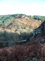
The Western Cleddau is an example of a “misfit” river: the valley is deep, often spectacularly so, although the stream that flows in it is small. The valley was formed at the end of the last Ice Age, when the River Teifi
, swollen with melt waters, was prevented from flowing into the Irish Sea by an ice dam, and flowed instead westward through the valleys of the Nyfer
and Gwaun
, then south along the course of the Western Cleddau.
Historically, the tidal estuary enabled sea traffic to reach Haverfordwest. It was important also for the export of anthracite, which was mined on its west bank and shipped from Hook.
– the Daugleddau - from Picton Point to the Blockhouse
s guarding the harbour entrance, is a massive ria
which is deep and wide, but sufficiently serpentine to be sheltered from high winds and rough seas, and is thus an excellent natural harbour. Because it can easily accommodate supertankers of 300,000 tonnes and more, it became from 1957 an important centre of the oil industry, with Esso
, BP, Texaco
, Gulf Oil
and Amoco
operating terminals and oil refineries. In the mid-1970s, it became briefly the UK’s second biggest port in terms of tonnage. The Daugleddau and its several tributary tidal reaches are known collectively as Milford Haven
. Length (from Picton Point to the Blockhouses) about 27 km.
Historically, the estuary gave seaborne access to castles such as Pembroke
and Carew
, allowing these to be used as depots in the Norman invasion of Ireland
. It was important in the early Industrial Revolution
, shipping anthracite from Llangwm
, Landshipping and Crescelly, and limestone
from Lawrenny and West Williamston
. A small fishing industry operated from harbours such as Pill, Angle and Dale, but in 1790 the building of the new town of Milford commenced, and a large herring
fishery grew up based on its docks. In its heyday, it became the UK’s seventh largest fishing port, operating several hundred fishing trawlers, but with exhaustion of inshore fishing grounds, the docks were too small for large ocean-going trawlers, and fishing is now virtually totally non-existent. Milford was originally built for a naval dockyard, but this project was transferred in 1814 to Pembroke Dock
on the opposite side of the estuary, where it operated until closure in 1926. The town of Neyland
, originally known as New Milford, was also purpose-built, this time by the Great Western Railway
as a transatlantic shipping terminal. Its functions were largely transferred to Fishguard
in the early 20th century.
that has been largely untouched by man's activities. The rivers support otter
populations and a wide variety if fish species including Lamprey
s. Because of this a large stretch of both rivers branches have been designated as SSSI
s because they are:
Pembrokeshire
Pembrokeshire is a county in the south west of Wales. It borders Carmarthenshire to the east and Ceredigion to the north east. The county town is Haverfordwest where Pembrokeshire County Council is headquartered....
, west Wales
Wales
Wales is a country that is part of the United Kingdom and the island of Great Britain, bordered by England to its east and the Atlantic Ocean and Irish Sea to its west. It has a population of three million, and a total area of 20,779 km²...
. They unite to form the Daugleddau estuary, which forms the important harbour of Milford Haven
Milford Haven (harbour)
Milford Haven Waterway is a natural harbour in Pembrokeshire, West Wales. The Haven is a ria or drowned valley flooded at the end of the last Ice Age. formed by the Pembroke River and the Daugleddau estuary, and winds west to the sea...
.
The name of the combined estuary – the Daugleddau – means “the two Cleddaus”. The name Cleddau, whilst seeming to be a plural ('-au' generally denotes plurality in Welsh
Welsh language
Welsh is a member of the Brythonic branch of the Celtic languages spoken natively in Wales, by some along the Welsh border in England, and in Y Wladfa...
) comes from the Welsh word 'cleddyf' meaning 'sword' and refers perhaps to the manner in which both rivers are incised into the landscape of Pembrokeshire.
Eastern Cleddau
Preseli Hills
The Preseli Hills or Preseli Mountains are a range of hills in north Pembrokeshire, West Wales...
at Blaencleddau 51.9639°N 4.6711°W in the parish of Mynachlog-ddu
Mynachlog-ddu
Mynachlog-ddu is a village, and community in the Preseli Hills, Pembrokeshire, Wales. The community also includes the parish of Llangolman.There are two places of worship in the village: the Anglican church of St...
. It flows southwest through a broad moorland valley to Gelli Mill, where the Syfnwy river joins it. It then flows south through a deep picturesque valley past Llawhaden
Llawhaden
Llawhaden is a village and parish in the Hundred of Dungleddy , Pembrokeshire, West Wales.Llawhaden was a civil parish, area 1865 Ha....
and becomes tidal at Canaston Bridge
Canaston Bridge
Canaston Bridge is a village in Pembrokeshire, southwest Wales. It is on the edge of the Pembrokeshire Coast National Park, northeast of Pembroke....
, the lowest crossing point. The estuary joins that of the Western Cleddau at Picton Point 51°45′55"N 4°53′40"W. Length about 34 km of which about 7 km is tidal.
Western Cleddau
The Western Cleddau has two branches: the eastern branch rises at Llygad Cleddau 51.9678°N 4.9465°W in the parish of Llanfair Nant y Gôf, 4 km south-east of FishguardFishguard
Fishguard is a coastal town in Pembrokeshire, south-west Wales, with a population of 3,300 . The community of Fishguard and Goodwick had a population of 5043 at the 2001 census....
. It flows southwest past Scleddau, and meets the western branch at Priskilly 51.9370°N 5.0257°W. The western branch rises at Penysgwarne 51.9315°N 5.1373°W in the parish of Llanreithan and flows east to Priskilly. The combined stream flows through Wolf’s Castle, where it enters the spectacular 90 m deep Treffgarne gorge, cutting through the hard volcanic rocks of Treffgarne Mountain. It then flows south to Haverfordwest
Haverfordwest
Haverfordwest is the county town of Pembrokeshire, Wales and serves as the County's principal commercial and administrative centre. Haverfordwest is the most populous urban area in Pembrokeshire, with a population of 13,367 in 2001; though its community boundaries make it the second most populous...
, where it becomes tidal, this being the lowest bridge crossing. The tidal estuary expands into a deep ria
Ria
A ria is a coastal inlet formed by the partial submergence of an unglaciated river valley. It is a drowned river valley that remains open to the sea. Typically, rias have a dendritic, treelike outline although they can be straight and without significant branches. This pattern is inherited from the...
, and unites with the Eastern Cleddau estuary at Picton Point, to form the Daugleddau estuary. Length (Penysgwarne to Picton Point) about 40 km, of which about 9 km is tidal.
The Western Cleddau is an example of a “misfit” river: the valley is deep, often spectacularly so, although the stream that flows in it is small. The valley was formed at the end of the last Ice Age, when the River Teifi
River Teifi
The River Teifi forms the boundary between the counties of Ceredigion and Carmarthenshire in south-west Wales for most of its 75 mile length, flowing into the sea below the town of Cardigan. The catchment of the river is estimated to be 1,008 square kilometres yielding an average flow at Glan...
, swollen with melt waters, was prevented from flowing into the Irish Sea by an ice dam, and flowed instead westward through the valleys of the Nyfer
Afon Nyfer
The Afon Nyfer is a river in North Pembrokeshire, West Wales which runs into the Irish Sea.The river rises at Blaencwm , just east of Crymych. It flows northward then westward, skirting the slopes of the Preseli Hills. It passes through Felindre Farchog and Nevern, and reaches the sea at Newport...
and Gwaun
River Gwaun
The River Gwaun is a river in Pembrokeshire, West Wales, which flows principally westwards draining to the sea into Fishguard Bay at Fishguard....
, then south along the course of the Western Cleddau.
Historically, the tidal estuary enabled sea traffic to reach Haverfordwest. It was important also for the export of anthracite, which was mined on its west bank and shipped from Hook.
Daugleddau Estuary and Milford Haven
The combined estuaryEstuary
An estuary is a partly enclosed coastal body of water with one or more rivers or streams flowing into it, and with a free connection to the open sea....
– the Daugleddau - from Picton Point to the Blockhouse
Blockhouse
In military science, a blockhouse is a small, isolated fort in the form of a single building. It serves as a defensive strong point against any enemy that does not possess siege equipment or, in modern times, artillery...
s guarding the harbour entrance, is a massive ria
Ria
A ria is a coastal inlet formed by the partial submergence of an unglaciated river valley. It is a drowned river valley that remains open to the sea. Typically, rias have a dendritic, treelike outline although they can be straight and without significant branches. This pattern is inherited from the...
which is deep and wide, but sufficiently serpentine to be sheltered from high winds and rough seas, and is thus an excellent natural harbour. Because it can easily accommodate supertankers of 300,000 tonnes and more, it became from 1957 an important centre of the oil industry, with Esso
Esso
Esso is an international trade name for ExxonMobil and its related companies. Pronounced , it is derived from the initials of the pre-1911 Standard Oil, and as such became the focus of much litigation and regulatory restriction in the United States. In 1972, it was largely replaced in the U.S. by...
, BP, Texaco
Texaco
Texaco is the name of an American oil retail brand. Its flagship product is its fuel "Texaco with Techron". It also owns the Havoline motor oil brand....
, Gulf Oil
Gulf Oil
Gulf Oil was a major global oil company from the 1900s to the 1980s. The eighth-largest American manufacturing company in 1941 and the ninth-largest in 1979, Gulf Oil was one of the so-called Seven Sisters oil companies...
and Amoco
Amoco
Amoco Corporation, originally Standard Oil Company , was a global chemical and oil company, founded in 1889 around a refinery located in Whiting, Indiana, United States....
operating terminals and oil refineries. In the mid-1970s, it became briefly the UK’s second biggest port in terms of tonnage. The Daugleddau and its several tributary tidal reaches are known collectively as Milford Haven
Milford Haven (harbour)
Milford Haven Waterway is a natural harbour in Pembrokeshire, West Wales. The Haven is a ria or drowned valley flooded at the end of the last Ice Age. formed by the Pembroke River and the Daugleddau estuary, and winds west to the sea...
. Length (from Picton Point to the Blockhouses) about 27 km.
Historically, the estuary gave seaborne access to castles such as Pembroke
Pembroke Castle
Pembroke Castle is a medieval castle in Pembroke, West Wales. Standing beside the River Cleddau, it underwent major restoration work in the early 20th century. The castle was the original seat of the Earldom of Pembroke....
and Carew
Carew Castle
Carew Castle is a castle in the civil parish of Carew in the Welsh county of Pembrokeshire. The famous Carew family take their name from the place, and still own the castle, although it is leased to the Pembrokeshire Coast National Park, which administers the site.-Construction:The present castle,...
, allowing these to be used as depots in the Norman invasion of Ireland
Norman Invasion of Ireland
The Norman invasion of Ireland was a two-stage process, which began on 1 May 1169 when a force of loosely associated Norman knights landed near Bannow, County Wexford...
. It was important in the early Industrial Revolution
Industrial Revolution
The Industrial Revolution was a period from the 18th to the 19th century where major changes in agriculture, manufacturing, mining, transportation, and technology had a profound effect on the social, economic and cultural conditions of the times...
, shipping anthracite from Llangwm
Llangwm
Llangwm could be one of several places in Wales:*Llangwm, Conwy*Llangwm, Monmouthshire*Llangwm, Pembrokeshire...
, Landshipping and Crescelly, and limestone
Limestone
Limestone is a sedimentary rock composed largely of the minerals calcite and aragonite, which are different crystal forms of calcium carbonate . Many limestones are composed from skeletal fragments of marine organisms such as coral or foraminifera....
from Lawrenny and West Williamston
Carew
Carew may refer to:People*Baron Carew, a title in the British peerage*Sir Alexander Carew, 2nd Baronet , British Member of Parliament involved in the English Civil War*Ashley Carew , English-Barbadian football player...
. A small fishing industry operated from harbours such as Pill, Angle and Dale, but in 1790 the building of the new town of Milford commenced, and a large herring
Herring
Herring is an oily fish of the genus Clupea, found in the shallow, temperate waters of the North Pacific and the North Atlantic oceans, including the Baltic Sea. Three species of Clupea are recognized. The main taxa, the Atlantic herring and the Pacific herring may each be divided into subspecies...
fishery grew up based on its docks. In its heyday, it became the UK’s seventh largest fishing port, operating several hundred fishing trawlers, but with exhaustion of inshore fishing grounds, the docks were too small for large ocean-going trawlers, and fishing is now virtually totally non-existent. Milford was originally built for a naval dockyard, but this project was transferred in 1814 to Pembroke Dock
Pembroke Dock
Pembroke Dock is a town in Pembrokeshire, south-west Wales, lying north of Pembroke on the River Cleddau. Originally a small fishing village known as Paterchurch, the town was greatly expanded from 1814 onwards following the construction of a Royal Naval Dockyard...
on the opposite side of the estuary, where it operated until closure in 1926. The town of Neyland
Neyland
Neyland is a town in Pembrokeshire, Wales, lying on the River Cleddau and the upstream end of the Milford Haven estuary. The nearby Cleddau Bridge crosses the river, linking Neyland to Pembroke Dock.-History:...
, originally known as New Milford, was also purpose-built, this time by the Great Western Railway
Great Western Railway
The Great Western Railway was a British railway company that linked London with the south-west and west of England and most of Wales. It was founded in 1833, received its enabling Act of Parliament in 1835 and ran its first trains in 1838...
as a transatlantic shipping terminal. Its functions were largely transferred to Fishguard
Fishguard
Fishguard is a coastal town in Pembrokeshire, south-west Wales, with a population of 3,300 . The community of Fishguard and Goodwick had a population of 5043 at the 2001 census....
in the early 20th century.
Ecology
Both branches of the Cleddau are noteworthy for their diverse aquatic ecologyEcology
Ecology is the scientific study of the relations that living organisms have with respect to each other and their natural environment. Variables of interest to ecologists include the composition, distribution, amount , number, and changing states of organisms within and among ecosystems...
that has been largely untouched by man's activities. The rivers support otter
Otter
The Otters are twelve species of semi-aquatic mammals which feed on fish and shellfish, and also other invertebrates, amphibians, birds and small mammals....
populations and a wide variety if fish species including Lamprey
Lamprey
Lampreys are a family of jawless fish, whose adults are characterized by a toothed, funnel-like sucking mouth. Translated from an admixture of Latin and Greek, lamprey means stone lickers...
s. Because of this a large stretch of both rivers branches have been designated as SSSI
Site of Special Scientific Interest
A Site of Special Scientific Interest is a conservation designation denoting a protected area in the United Kingdom. SSSIs are the basic building block of site-based nature conservation legislation and most other legal nature/geological conservation designations in Great Britain are based upon...
s because they are:
of special interest primarily for important populations of otter Lutra lutra, bullhead Cottus gobio, river lamprey Lampetra fluviatilis and brook lamprey Lampetra planeri. They are also of special interest for sea lamprey Petromyzon marinus; for the range of river habitats including beds of submerged aquatic plants often dominated by water-crowfoot Ranunculus spp., as well as a variety of associated riverside habitats. The tributaries included within this site are the Afon Cleddau, Nant-y-bugail, Afon Anghof, Nant-y-coy Brook, Spittal Brook, Rudbaxton Water, Camrose Brook , Cartlett Brook, Afon Wern, Llanycefn, Rhyd-afallen, Afon Syfynwy, Rhyd-y-Brown Brook, Ty-llosg Brook, Deepford Brook, Cotland Brook, Afon Conin, Pont Shan and Narberth Brookhttp://www.ccw.gov.uk/landscape--wildlife/protecting-our-landscape/protected-sites-map.aspx