
Richmond-San Rafael Bridge
Encyclopedia
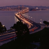
The Richmond – San Rafael Bridge (officially, the John F. McCarthy Memorial Bridge) is the northernmost of the east–west crossings of the San Francisco Bay
in California
, USA
, connecting Richmond
on the east to San Rafael
on the west end. It opened in 1956 replacing ferry service by the Richmond – San Rafael Ferry Company.
type. To save money, both main cantilever sections were designed identically, including the angles, necessitating the "dip" in the central section, giving the bridge a "roller coaster
" appearance and also the nickname "roller coaster span". This appearance has also been referred to as a "bent coat hanger". After it was completed, many were disappointed by the aesthetics of the low budget bridge, especially when compared to the engineering and historical marvels of the neighboring Golden Gate Bridge
and the Bay Bridge.
According to Dennis McNally, Jerry Garcia
conceived the idea for the Grateful Dead
song Terrapin Station
while driving across the Richmond – San Rafael Bridge.
Golden Gate Transit
bus routes 40 and 42 provide public transportation across the bridge, connecting El Cerrito del Norte BART
and Richmond BART/Amtrak
(42 only) stations and other locations in Richmond with San Rafael Transit Center
and other locations in San Rafael.
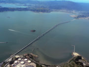
. Upon its opening, the Richmond – San Rafael bridge was the last bridge across San Francisco Bay to replace a previous ferry service, leaving the Benicia–Martinez Ferry across Carquinez Strait as the only remaining auto ferry in the Bay Area (it would be replaced by a bridge in 1962). Each deck of the bridge has 2 lanes and a shoulder; westbound traffic rides on the upper deck, while eastbound traffic rides on the lower deck.
Construction was financed by the sale of $62 million in revenue bonds, along with a loan of $4.68 million from the State School Land Fund. The bridge was finished $4 million under budget.
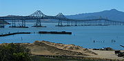
 The bridge recently underwent an extensive seismic retrofit
program, similar to other bridges in the area. The fifty-year-old bridge was also showing its age and required age-related maintenance which was performed in conjunction with the seismic upgrade work. There were reports of cars being damaged while traveling on the lower deck by fist-sized concrete chunks falling from the joints of upper deck slabs.
A major part of the retrofit involved the long concrete causeway on the Marin side, which as part of the retrofit program was nearly completely replaced. Because of the active use of the bridge, Caltrans designed the retrofit project so as to allow the bridge to remain open to traffic. For economy, schedule efficiency and traffic impact mitigation, much of the repair of the bridge involved work being fabricated off site and shipment to the bridge over water by barge.
To reduce impacts to the ongoing traffic the major activities of work were scheduled at night. Caltrans had to keep two lanes of traffic moving in each direction during daylight hours, but then they reduced that flow to a single lane in each direction at night. Thus, one trestle was completely closed for construction work, and two-way traffic was transferred to the other trestle.
The concrete segments of the trestle were precast in Petaluma and barged down to the bridge. At monthly intervals tugs position barges with one or two 100-foot (30 m) long, 500-ton pre-cast concrete roadway segments ready to be lifted into place by a 900-ton barge-mounted crane. Earlier, either two or four of the corroded, 50-ft (15 m) concrete segments of the old roadway were removed by crane. Then, a pile driver was moved into position for driving new piles. After the new concrete road segment was in place, steel plates were used to temporarily fill the gaps, and the roadway was ready for the morning rush-hour traffic. The construction resulted in a nightmare for commuters. At times, the Richmond – San Rafael Bridge construction ended up backing traffic all the way to Highway 101 into Central San Rafael though many of these users of the bridge are also grateful that the bridge now is more likely to withstand the risk of damage in a major earthquake.
However, the completion of this retrofit, on September 22, 2005 was celebrated as a success despite the many challenges, including the deaths of two workers. The $540 million project, at the time the largest individual contract in Caltrans history, came in $136 million dollars under budget.
The retrofit is intended to allow the two-tier bridge to withstand a 7.4 magnitude earthquake on the Hayward Fault and an 8.3 magnitude quake on the San Andreas Fault.
 In both directions, the bridge is wide enough to accommodate three lanes of traffic. Currently the third lane is used as a right-hand shoulder or a "breakdown lane" and is marked along the bridge with the signs "Emergency Parking Only". However, in 1989, after the Loma Prieta earthquake
, the third lane was opened up as a normal lane to accommodate the increased amount of traffic after the Bay Bridge was shut down because of a failure of that span. Many commuters from San Francisco drove across the Golden Gate Bridge into Marin and then across the Richmond – San Rafael Bridge to go to Oakland (and vice versa). But then, once the Bay Bridge was reopened, that third lane went back to being an emergency lane.
In 1977, Marin County was suffering one of its worst water droughts in history. A temporary on-surface pipeline, six miles (10 km) long, was placed in the third lane. The pipe transferred eight million gallons of water a day from the East Bay Municipal Utility District
's mains in Richmond to Marin's 170,000 residents. By 1978, the drought subsided and the pipeline was removed. The disused third lane was finally striped as a shoulder.
Since the construction of the bridge, there has been a longtime debate to make the third lane a bike lane. In 2001, a study confirmed that bicycle travel was legal and would be adequate in the 12' shoulder space provided by the bridge. However, to this day bicycle riders still are not able to cross the bridge, as the third lane still sits as an emergency lane.
For ten years, the Metropolitan Transportation Commition (MTC) and the Bay Area Toll authority tried to make the shoulder a regular lane of traffic and a bike lane. A movable barrier would be in place and the third lane would be a regular lane of traffic during rush hour and a bike lane when not needed. Caltrans rejected the idea, arguing the emergency lane is needed for safety. The rejection has upset some people. The shoulder was needed on January 4, 2008 (read section below).
-->]]
San Francisco Bay
San Francisco Bay is a shallow, productive estuary through which water draining from approximately forty percent of California, flowing in the Sacramento and San Joaquin rivers from the Sierra Nevada mountains, enters the Pacific Ocean...
in California
California
California is a state located on the West Coast of the United States. It is by far the most populous U.S. state, and the third-largest by land area...
, USA
United States
The United States of America is a federal constitutional republic comprising fifty states and a federal district...
, connecting Richmond
Richmond, California
Richmond is a city in western Contra Costa County, California, United States. The city was incorporated on August 7, 1905. It is located in the East Bay, part of the San Francisco Bay Area. It is a residential inner suburb of San Francisco, as well as the site of heavy industry, which has been...
on the east to San Rafael
San Rafael, California
San Rafael is a city and the county seat of Marin County, California, United States. The city is located in the North Bay region of the San Francisco Bay Area...
on the west end. It opened in 1956 replacing ferry service by the Richmond – San Rafael Ferry Company.
Description
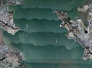
The bridge—including approaches—measures 5.5 miles (29,040 feet / 8,851.39 m / 8.9 km) long. At the time it was built, it was one of the world's longest bridges. The bridge spans two principal ship channels and has two separate major spans, each of the cantileverCantilever bridge
A cantilever bridge is a bridge built using cantilevers, structures that project horizontally into space, supported on only one end. For small footbridges, the cantilevers may be simple beams; however, large cantilever bridges designed to handle road or rail traffic use trusses built from...
type. To save money, both main cantilever sections were designed identically, including the angles, necessitating the "dip" in the central section, giving the bridge a "roller coaster
Roller coaster
The roller coaster is a popular amusement ride developed for amusement parks and modern theme parks. LaMarcus Adna Thompson patented the first coasters on January 20, 1885...
" appearance and also the nickname "roller coaster span". This appearance has also been referred to as a "bent coat hanger". After it was completed, many were disappointed by the aesthetics of the low budget bridge, especially when compared to the engineering and historical marvels of the neighboring Golden Gate Bridge
Golden Gate Bridge
The Golden Gate Bridge is a suspension bridge spanning the Golden Gate, the opening of the San Francisco Bay into the Pacific Ocean. As part of both U.S. Route 101 and California State Route 1, the structure links the city of San Francisco, on the northern tip of the San Francisco Peninsula, to...
and the Bay Bridge.
According to Dennis McNally, Jerry Garcia
Jerry Garcia
Jerome John "Jerry" Garcia was an American musician best known for his lead guitar work, singing and songwriting with the band the Grateful Dead...
conceived the idea for the Grateful Dead
Grateful Dead
The Grateful Dead was an American rock band formed in 1965 in the San Francisco Bay Area. The band was known for its unique and eclectic style, which fused elements of rock, folk, bluegrass, blues, reggae, country, improvisational jazz, psychedelia, and space rock, and for live performances of long...
song Terrapin Station
Terrapin Station
Terrapin Station is the ninth studio album by the Grateful Dead, and was originally released on July 27, 1977.This album was the first time since Anthem of the Sun that the Grateful Dead used an outside producer...
while driving across the Richmond – San Rafael Bridge.
Golden Gate Transit
Golden Gate Transit
Golden Gate Transit is a public transportation system serving the North Bay region of the San Francisco Bay Area in California, United States. It mainly serves Marin and Sonoma Counties, and also provides limited service to San Francisco and Contra Costa County.Golden Gate Transit is one of three...
bus routes 40 and 42 provide public transportation across the bridge, connecting El Cerrito del Norte BART
El Cerrito del Norte (BART station)
El Cerrito del Norte, frequenly shorterned to del Norte, is one of two BART stations in El Cerrito, California, just east of the Cutting Boulevard interchange of Interstate 80 parallel to San Pablo Avenue and the Ohlone Greenway straddling the Richmond border. Del Norte opened to revenue service on...
and Richmond BART/Amtrak
Richmond Station (California)
Richmond Station is an at-grade Bay Area Rapid Transit and Amtrak station located in Richmond, California. Each system is served by an island platform. The Capitol Corridor, San Joaquins, California Zephyr, and Coast Starlight stop here and connect to BART. The station is currently being rebuilt...
(42 only) stations and other locations in Richmond with San Rafael Transit Center
San Rafael Transit Center
The San Rafael Transportation Center , in San Rafael, California, is the main transit center for Marin County. From San Rafael, passengers can travel throughout Marin County, to San Francisco, Contra Costa, and Sonoma Counties...
and other locations in San Rafael.
History
Originally a part of State Route 17, the bridge is now part of Interstate 580Interstate 580 (California)
Interstate 580 is an 80-mile east–west Interstate Highway in Northern California. The heavily traveled spur route of Interstate 80 runs from San Rafael in the San Francisco Bay Area to Interstate 5 near Tracy in the Central Valley...
. Upon its opening, the Richmond – San Rafael bridge was the last bridge across San Francisco Bay to replace a previous ferry service, leaving the Benicia–Martinez Ferry across Carquinez Strait as the only remaining auto ferry in the Bay Area (it would be replaced by a bridge in 1962). Each deck of the bridge has 2 lanes and a shoulder; westbound traffic rides on the upper deck, while eastbound traffic rides on the lower deck.
Construction was financed by the sale of $62 million in revenue bonds, along with a loan of $4.68 million from the State School Land Fund. The bridge was finished $4 million under budget.
Seismic Retrofit
Seismic retrofit
Seismic retrofitting is the modification of existing structures to make them more resistant to seismic activity, ground motion, or soil failure due to earthquakes. With better understanding of seismic demand on structures and with our recent experiences with large earthquakes near urban centers,...
program, similar to other bridges in the area. The fifty-year-old bridge was also showing its age and required age-related maintenance which was performed in conjunction with the seismic upgrade work. There were reports of cars being damaged while traveling on the lower deck by fist-sized concrete chunks falling from the joints of upper deck slabs.
A major part of the retrofit involved the long concrete causeway on the Marin side, which as part of the retrofit program was nearly completely replaced. Because of the active use of the bridge, Caltrans designed the retrofit project so as to allow the bridge to remain open to traffic. For economy, schedule efficiency and traffic impact mitigation, much of the repair of the bridge involved work being fabricated off site and shipment to the bridge over water by barge.
To reduce impacts to the ongoing traffic the major activities of work were scheduled at night. Caltrans had to keep two lanes of traffic moving in each direction during daylight hours, but then they reduced that flow to a single lane in each direction at night. Thus, one trestle was completely closed for construction work, and two-way traffic was transferred to the other trestle.
The concrete segments of the trestle were precast in Petaluma and barged down to the bridge. At monthly intervals tugs position barges with one or two 100-foot (30 m) long, 500-ton pre-cast concrete roadway segments ready to be lifted into place by a 900-ton barge-mounted crane. Earlier, either two or four of the corroded, 50-ft (15 m) concrete segments of the old roadway were removed by crane. Then, a pile driver was moved into position for driving new piles. After the new concrete road segment was in place, steel plates were used to temporarily fill the gaps, and the roadway was ready for the morning rush-hour traffic. The construction resulted in a nightmare for commuters. At times, the Richmond – San Rafael Bridge construction ended up backing traffic all the way to Highway 101 into Central San Rafael though many of these users of the bridge are also grateful that the bridge now is more likely to withstand the risk of damage in a major earthquake.
However, the completion of this retrofit, on September 22, 2005 was celebrated as a success despite the many challenges, including the deaths of two workers. The $540 million project, at the time the largest individual contract in Caltrans history, came in $136 million dollars under budget.
The retrofit is intended to allow the two-tier bridge to withstand a 7.4 magnitude earthquake on the Hayward Fault and an 8.3 magnitude quake on the San Andreas Fault.
Use of Third Lane
Loma Prieta earthquake
The Loma Prieta earthquake, also known as the Quake of '89 and the World Series Earthquake, was a major earthquake that struck the San Francisco Bay Area of California on October 17, 1989, at 5:04 p.m. local time...
, the third lane was opened up as a normal lane to accommodate the increased amount of traffic after the Bay Bridge was shut down because of a failure of that span. Many commuters from San Francisco drove across the Golden Gate Bridge into Marin and then across the Richmond – San Rafael Bridge to go to Oakland (and vice versa). But then, once the Bay Bridge was reopened, that third lane went back to being an emergency lane.
In 1977, Marin County was suffering one of its worst water droughts in history. A temporary on-surface pipeline, six miles (10 km) long, was placed in the third lane. The pipe transferred eight million gallons of water a day from the East Bay Municipal Utility District
East Bay Municipal Utility District
East Bay Municipal Utility District , colloquially referred to as "East Bay Mud", provides water and sewage treatment for customers in portions of Alameda County and Contra Costa County in California, on the eastern side of San Francisco Bay, including the cities of Richmond, El Cerrito, Hercules,...
's mains in Richmond to Marin's 170,000 residents. By 1978, the drought subsided and the pipeline was removed. The disused third lane was finally striped as a shoulder.
Since the construction of the bridge, there has been a longtime debate to make the third lane a bike lane. In 2001, a study confirmed that bicycle travel was legal and would be adequate in the 12' shoulder space provided by the bridge. However, to this day bicycle riders still are not able to cross the bridge, as the third lane still sits as an emergency lane.
For ten years, the Metropolitan Transportation Commition (MTC) and the Bay Area Toll authority tried to make the shoulder a regular lane of traffic and a bike lane. A movable barrier would be in place and the third lane would be a regular lane of traffic during rush hour and a bike lane when not needed. Caltrans rejected the idea, arguing the emergency lane is needed for safety. The rejection has upset some people. The shoulder was needed on January 4, 2008 (read section below).
Closures
The bridge was closed on the morning of Friday, January 4, 2008 as a southerly wind gusting to nearly 70 mi/h buffeted the span, knocking over four trucks on the lower deck and one truck on the upper deck. The bridge was closed for six hours. It was re-opened by late afternoon as the strong winds subsided.External links
- With Little Fanfare... Marin IJ article on the 50th anniversary of the bridge
- Richmond-San Rafael Bridge Retrofit Completed
- Caltrans Seismic Retrofit overview
- California Dept. of Transportation: Richmond-San Rafael Bridge History & Information
- Univ. of California, Berkeley: Bridging the Bay: Richmond-San Rafael Bridge
- Decades of Struggle for Bicycle Access
- Bay Area Toll Authority - Bridge Facts - Richmond-San Rafael Bridge
- Footage of the official bridge opening ceremony from September 1956
- Eastern cantilever span from Point Richmond looking West
-->]]