
Red Rock-Secret Mountain Wilderness
Encyclopedia
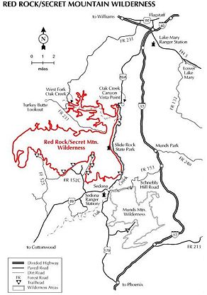
The Red Rock-Secret Mountain Wilderness is a 47194 acres (191 km²) wilderness area located within the Coconino National Forest
Coconino National Forest
The Coconino National Forest is a 1.856-million acre United States National Forest located in northern Arizona in the vicinity of Flagstaff. Originally established in 1898 as the "San Francisco Mountains National Forest Reserve", the area was designated a U.S...
in the U.S.
United States
The United States of America is a federal constitutional republic comprising fifty states and a federal district...
state of Arizona
Arizona
Arizona ; is a state located in the southwestern region of the United States. It is also part of the western United States and the mountain west. The capital and largest city is Phoenix...
.
The Wilderness is predominantly wind and water sculpted pinnacles, windows, arches
Natural arch
A natural arch or natural bridge is a natural geological formation where a rock arch forms, with an opening underneath. Most natural arches form as a narrow ridge, walled by cliffs, become narrower from erosion, with a softer rock stratum under the cliff-forming stratum gradually eroding out until...
, and slot canyon
Slot canyon
A slot canyon is a narrow canyon, formed by the wear of water rushing through rock. A slot canyon is significantly deeper than it is wide. Some slot canyons can measure less than one metre across at the top but drop more than 30 m to the floor of the canyon.Most slot canyons are formed in...
s, and the red-rock cliffs of the Mogollon Rim
Mogollon Rim
The Mogollon Rim is a topographical and geological feature running across the U.S. state of Arizona. It extends approximately from northern Yavapai County eastward to near the border with New Mexico.-Description:...
that mark the edge of the Colorado Plateau
Colorado Plateau
The Colorado Plateau, also called the Colorado Plateau Province, is a physiographic region of the Intermontane Plateaus, roughly centered on the Four Corners region of the southwestern United States. The province covers an area of 337,000 km2 within western Colorado, northwestern New Mexico,...
. Bordered on the east by Sycamore Canyon Wilderness, the high mesas of Secret Mountain and Wilson Mountain jut out into the lower country and canyons as deep as 1500 feet (457 m) drain into Oak Creek and the Verde River
Verde River
The Verde River is the north and northwestern watershed of the Salt River–Verde River Watershed that co-join and enter the Gila River at Phoenix, Arizona, located in the U.S. state of Arizona...
.
Prehistoric rock art and abandoned cliff dwellings can be found in the Wilderness.
Wildlife
The high rims are relatively cool and moist compared with the lower desertland of the Wilderness, and a wide variety of vegetation supports plentiful wildlife, including elkElk
The Elk is the large deer, also called Cervus canadensis or wapiti, of North America and eastern Asia.Elk may also refer to:Other antlered mammals:...
, mule deer
Mule Deer
The mule deer is a deer indigenous to western North America. The Mule Deer gets its name from its large mule-like ears. There are believed to be several subspecies, including the black-tailed deer...
, white-tailed deer
White-tailed Deer
The white-tailed deer , also known as the Virginia deer or simply as the whitetail, is a medium-sized deer native to the United States , Canada, Mexico, Central America, and South America as far south as Peru...
, javelina, coyote
Coyote
The coyote , also known as the American jackal or the prairie wolf, is a species of canine found throughout North and Central America, ranging from Panama in the south, north through Mexico, the United States and Canada...
, rabbit
Rabbit
Rabbits are small mammals in the family Leporidae of the order Lagomorpha, found in several parts of the world...
, mountain lion, and black bear
American black bear
The American black bear is a medium-sized bear native to North America. It is the continent's smallest and most common bear species. Black bears are omnivores, with their diets varying greatly depending on season and location. They typically live in largely forested areas, but do leave forests in...
.
Recreation
Common recreational activities in the Red Rock-Secret Mountain Wilderness include horseback riding, photography, wildlife viewing, swimming, and hiking. There are numerous short trails in the Wilderness:- Mooney #12 (4.2 miles (6.8 km)) - Originally built to drive cattle to and from summer pastures on the Mogollon Rim, and still used for this purpose, the trail is steep and the views are good.
- Vultee Arch #22 (1.75 miles (2.8 km)) - This trail follows the bottom of Sterling Canyon, a drainage that is dry most of the year. It dead ends at a bronze plaque placed in memoriam for Gerard and Sylvia Vultee who lost their lives in an aircraft crash on January 29, 1938. The actual crash site is more than a mile north and at a much higher elevation, on East Picket Mesa. On the north side of the canyon across from the plaque is the sandstone arch named for Vultee, an early aircraft designer from California.
- Dry Creek #52 (2.5 miles (4 km)) - This trail is often hiked as part of a 6.2 miles (10 km) loop.
- Sterling Pass #46 (2.4 miles (3.9 km)) - Named for a local settler, this trail leads over a high saddle from Oak Creek Canyon into Sterling Canyon.
- A.B. Young #100 (2.4 miles (3.9 km)) - Believed to have been built originally by C.S. "Bear" Howard in the 1880s, it was reconstructed in the 1930s by the Civilian Conservation CorpsCivilian Conservation CorpsThe Civilian Conservation Corps was a public work relief program that operated from 1933 to 1942 in the United States for unemployed, unmarried men from relief families, ages 18–25. A part of the New Deal of President Franklin D...
and supervised by A.B. Young. - West Fork Trail #108 (3 miles (4.8 km)) - This is the most popular trail in the Coconino National Forest and hikers should not expect solitude.
- Secret Mountain #109 (5 miles (8 km)) - This trail winds along the south edge of Secret Mountain, past the tops of several deep canyons including Hart Well, Boynton, and Long, and ends at the 6607 feet (2,014 m) summit of Secret Mountain.
- Parson's Trail #144 (4 miles (6.4 km)) - This is a popular and crowded trail leading to a large pool called Parson Springs.
- Wilson Mountain/North Wilson #123 (5.6 miles (9 km)) - A strenuous 2300 feet (701 m) climb to a view stretching over hundreds of square miles of scenic canyon country.
- Brin's Mesa #119 (3 miles (4.8 km)) - Hike past Coffee Pot Rock, Wilson Mountain, and Chimney Rock to the expansive view at Brin's Mesa.
- Fay Canyon #53 (1.1 miles (1.8 km)) - This trail in a box canyon leads past a natural arch to a dead end with evidence of ancient Indian dwellings.
- Loy Canyon #5 (5 miles (8 km)) - This path was used by the Samuel Loy family in the 1880s to move their livestock to and from summer pastures on the Mogollon Rim. The trail features a 2300 feet (701 m) climb to the top of Secret Mountain.
- Boynton Canyon #47 (2.5 miles (4 km)) - Scenic, but somewhat busy, hike to a box canyonBox canyonBox Canyon is a Box canyon in Ouray County, Colorado, United States. It was originally founded as a mining camp and helped the city of Ouray establish itself as a permanent community. Box Canyon is home to Box Canyon Falls, a 285-foot waterfall, with quartzite walls that extend almost one hundred...
.
See also
- List of Arizona Wilderness Areas
- List of U.S. Wilderness Areas
- Wilderness ActWilderness ActThe Wilderness Act of 1964 was written by Howard Zahniser of The Wilderness Society. It created the legal definition of wilderness in the United States, and protected some 9 million acres of federal land. The result of a long effort to protect federal wilderness, the Wilderness Act was signed...
External links
- Red Rock/Secret Mountain Wilderness - Coconino National Forest
- "Fire in Red Rock Secret Mountain area causes trail closure", Arizona Daily Sun, Saturday, March 15, 2008