

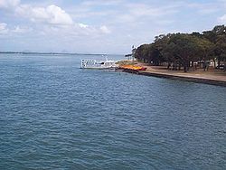
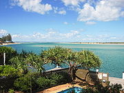
Pumicestone Passage
Encyclopedia
Queensland
Queensland is a state of Australia, occupying the north-eastern section of the mainland continent. It is bordered by the Northern Territory, South Australia and New South Wales to the west, south-west and south respectively. To the east, Queensland is bordered by the Coral Sea and Pacific Ocean...
, Australia. The northern extent of the passage is at Caloundra, while at the south is Deception Bay.
History
The passage was originally shown as Pumice-stone River on the maps of Matthew FlindersMatthew Flinders
Captain Matthew Flinders RN was one of the most successful navigators and cartographers of his age. In a career that spanned just over twenty years, he sailed with Captain William Bligh, circumnavigated Australia and encouraged the use of that name for the continent, which had previously been...
as he found an abundance of pumice
Pumice
Pumice is a textural term for a volcanic rock that is a solidified frothy lava typically created when super-heated, highly pressurized rock is violently ejected from a volcano. It can be formed when lava and water are mixed. This unusual formation is due to the simultaneous actions of rapid...
stone lining the shoreline. He was the first European explorer to enter Moreton Bay
Moreton Bay
Moreton Bay is a bay on the eastern coast of Australia 45 km from Brisbane, Queensland. It is one of Queensland's most important coastal resources...
in 1799 on the Sloop H. M. 'Norfolk'
Norfolk (sloop)
The Colonial sloop Norfolk: “The necessity of a vessel to keep up a more frequent intercourse with Norfolk Island, …having been much felt by the want of various stores …occasioned Captain Townson, the Commanding officer, to construct a small decked boat, sloop rigged, in which he sent His letters...
and spent two weeks exploring the bay and surrounds and naming Point Skirmish and Pumice-stone River.
Environment
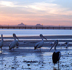
Gazetted in 1986, Pumicestone Passage Marine Park, extends from the southern entrance to the Caloundra bar and is just over 35 kilometres long via the channels and has a surface area of 63 km². The marine park has 24 islands and is bounded by 240 kilometres of shoreline. Eighty percent of the Passage is under two metres deep and dugongs frequent its waters seasonally to feed on the seagrass on the bottom of the channels in the passage. Dolphins and turtles also make the Passage home as do over 350 species of birds. Habitats within and adjoining the passage include mangroves and saltmarshes, sand flats and mud flats, coastal dunes and seagrassSeagrass
Seagrasses are flowering plants from one of four plant families , all in the order Alismatales , which grow in marine, fully saline environments.-Ecology:...
meadows.
The Passage forms part of the Moreton Bay and Pumicestone Passage Important Bird Area
Important Bird Area
An Important Bird Area is an area recognized as being globally important habitat for the conservation of bird populations. Currently there are about 10,000 IBAs worldwide. The program was developed and sites are identified by BirdLife International...
, so identified by BirdLife International
BirdLife International
BirdLife International is a global Partnership of conservation organisations that strives to conserve birds, their habitats and global biodiversity, working with people towards sustainability in the use of natural resources...
because it supports large numbers of migratory
Bird migration
Bird migration is the regular seasonal journey undertaken by many species of birds. Bird movements include those made in response to changes in food availability, habitat or weather. Sometimes, journeys are not termed "true migration" because they are irregular or in only one direction...
wader
Wader
Waders, called shorebirds in North America , are members of the order Charadriiformes, excluding the more marine web-footed seabird groups. The latter are the skuas , gulls , terns , skimmers , and auks...
s, or shorebirds.
See also
- DonnybrookDonnybrook, QueenslandDonnybrook is a small village 60 km north of Brisbane, the state capital of Queensland, Australia. At the 2006 census, Donnybrook had a population of 456.It started out as a small fishing community but has since developed into a minor tourist destination...
- Deception BayDeception Bay, QueenslandDeception Bay is a suburb north of Brisbane, Queensland, Australia. Its Local Government Area is the Moreton Bay Region and is located approximately 32 km north of Brisbane in the south-eastern corner of the bay of the same name which separates the Redcliffe peninsula and Bribie...