

Puerto Rico Highway 3
Encyclopedia
Puerto Rico Highway 3 at nearly 101 miles long, is the second longest highway on Puerto Rico
(after PR-2
). It connects the San Juan
neighborhood of Rio Piedras
to downtown Salinas
indirectly around the eastern coast of the island. Highway 3 ranges from a three lane urban avenue in San Juan to a one lane rural road past Fajardo.While other roads connect San Juan It runs the coastline of Puerto Rico east of San Juan
, beginning in Rio Piedras
near Santurce
(where it is known as the Avenida 65 de Infantería) and goes to Fajardo where it goes south paralleling the coastline to Humacao
and Maunabo
. It goes up to a mountain-scenic route and goes west to Salinas, where it meets PR-1.
in San Juan
as the three lane 65th Infantry Regiment
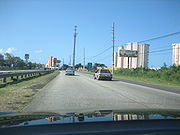
Avenue. Heading east through San Juan, Highway 3 functions as an urban boulevard with both at-grade and grade-separated intersections becoming decidedly suburban in character past the PR-26/66 overpass near downtown Carolina
. Recently, PR-66 was opened and it has controlled the high traffic on PR-3.
. In Fajardo, PR-53 begins and PR-3 becomes a one-lane per direction rural road, and keeps that way for the rest of its length, though there are some minor divided segments in Humacao near Junquito, a very small segment near Patagonia (close to its intersection with PR-30 and another segment in Arroyo and Guayama for about nearly 10 kilometers.
 The following are the municipalities through which PR-3 passes:
Loiza is the only coastal municipality not served by PR-3 in its length through the east shore until its intersection with PR-1 in Salinas. PR-188 serves as the main artery from the highway to Loiza. The remaining coasts of Puerto Rico (west of San Juan and west of Salinas) are served by PR-1 (West Salinas, Santa Isabel, Juana Diaz and East Ponce) and PR-2 (the rest of the coastline though some municipalities are not directly served). In Maunabo and south Yabucoa, PR-3 is not the main "at-grade" artery since it goes up in the mountains. PR-901 is the main at grade road in this segment of about 10 kilometers.
Puerto Rico
Puerto Rico , officially the Commonwealth of Puerto Rico , is an unincorporated territory of the United States, located in the northeastern Caribbean, east of the Dominican Republic and west of both the United States Virgin Islands and the British Virgin Islands.Puerto Rico comprises an...
(after PR-2
Puerto Rico Highway 2
Puerto Rico Highway 2, the longest highway in the Commonwealth of Puerto Rico at about 156 miles long, connects San Juan to Ponce....
). It connects the San Juan
San Juan, Puerto Rico
San Juan , officially Municipio de la Ciudad Capital San Juan Bautista , is the capital and most populous municipality in Puerto Rico, an unincorporated territory of the United States. As of the 2010 census, it had a population of 395,326 making it the 46th-largest city under the jurisdiction of...
neighborhood of Rio Piedras
Río Piedras, Puerto Rico
Río Piedras is a district of San Juan, Puerto Rico. Founded in 1714, it has been the home of the University of Puerto Rico's main campus since 1903, earning the town the popular name of Ciudad Universitaria...
to downtown Salinas
Salinas, Puerto Rico
Salinas is a small municipality in the southern part of Puerto Rico located in the southern coast of the island, south of Aibonito and Cayey; southeast of Coamo, east of Santa Isabel; and west of Guayama...
indirectly around the eastern coast of the island. Highway 3 ranges from a three lane urban avenue in San Juan to a one lane rural road past Fajardo.While other roads connect San Juan It runs the coastline of Puerto Rico east of San Juan
San Juan, Puerto Rico
San Juan , officially Municipio de la Ciudad Capital San Juan Bautista , is the capital and most populous municipality in Puerto Rico, an unincorporated territory of the United States. As of the 2010 census, it had a population of 395,326 making it the 46th-largest city under the jurisdiction of...
, beginning in Rio Piedras
Río Piedras, Puerto Rico
Río Piedras is a district of San Juan, Puerto Rico. Founded in 1714, it has been the home of the University of Puerto Rico's main campus since 1903, earning the town the popular name of Ciudad Universitaria...
near Santurce
Santurce, San Juan, Puerto Rico
Santurce is a district of San Juan, Puerto Rico.-Summary:Santurce is one of the top ten most populated areas of the island holding Miramar, Loíza, Isla Grande, Barrio Obrero, and Condado as main cultural hot spots for art, music, cuisine, fashion, hotels, technology, multimedia, film, textile and...
(where it is known as the Avenida 65 de Infantería) and goes to Fajardo where it goes south paralleling the coastline to Humacao
Humacao, Puerto Rico
Humacao is a city in Puerto Rico located in the eastern coast of the island, north of Yabucoa; south of Naguabo; east of Las Piedras; and west of Vieques Passage. Humacao is spread over 10 wards and Humacao Pueblo...
and Maunabo
Maunabo, Puerto Rico
Maunabo is a municipality of Puerto Rico located in the southeastern coast, northeast of Patillas and south of Yabucoa. Maunabo is spread over 8 wards and Maunabo Pueblo . It is part of the San Juan-Caguas-Guaynabo Metropolitan Statistical Area.The Mayor of the town is Jorge L. Márquez Pérez...
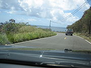
. It goes up to a mountain-scenic route and goes west to Salinas, where it meets PR-1.
San Juan to Rio Grande
PR-3 begins at an intersection with PR-1Puerto Rico Highway 1
Puerto Rico Highway 1 connects the city of Ponce to San Juan. Leaving Ponce, the road follows somewhat parallel along the southern coast of the island and, at Salinas, it turns north to cut through the Cordillera Central in its approach to San Juan....
in San Juan
San Juan, Puerto Rico
San Juan , officially Municipio de la Ciudad Capital San Juan Bautista , is the capital and most populous municipality in Puerto Rico, an unincorporated territory of the United States. As of the 2010 census, it had a population of 395,326 making it the 46th-largest city under the jurisdiction of...
as the three lane 65th Infantry Regiment
65th Infantry Regiment (United States)
The 65th Infantry Regiment, nicknamed "The Borinqueneers," was an all-volunteer Puerto Rican regiment of the United States Army. Its motto was Honor et Fidelitas, Latin for Honor and Fidelity. It participated in World War I, World War II, and the Korean War...
Avenue. Heading east through San Juan, Highway 3 functions as an urban boulevard with both at-grade and grade-separated intersections becoming decidedly suburban in character past the PR-26/66 overpass near downtown Carolina
Carolina, Puerto Rico
Carolina is a city located in the northern part of Puerto Rico, bordering the Atlantic Ocean; it lies north of Gurabo and Juncos; east of Trujillo Alto and San Juan; and west of Canóvanas and Loíza. Carolina is spread over 12 wards plus Carolina Pueblo...
. Recently, PR-66 was opened and it has controlled the high traffic on PR-3.
Rio Grande to Fajardo
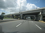
It is a divided highway to Fajardo, and the only main highway connecting Fajardo to Río GrandeRío Grande, Puerto Rico
Río Grande is a municipality of Puerto Rico located in the Northern Coastal Valley, North of Las Piedras, Naguabo and Ceiba; east of Loíza and Canóvanas and west of Luquillo. Río Grande is spread over eight wards and Río Grande Pueblo...
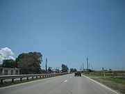
. In Fajardo, PR-53 begins and PR-3 becomes a one-lane per direction rural road, and keeps that way for the rest of its length, though there are some minor divided segments in Humacao near Junquito, a very small segment near Patagonia (close to its intersection with PR-30 and another segment in Arroyo and Guayama for about nearly 10 kilometers.
Puerto Rico Highway 53
Just like PR-22 parallels PR-2 and PR-52 parallels PR-1, PR-53 is the toll highway which parallels PR-3 and they have several exit intersections. Yet, PR-53 has not been completed and PR-3 serves as the main road in the southeastern part of Puerto Rico going from Yabucoa to Guayama, though PR-901 serves as a primary road (because it is shorter through it) between Yabucoa and Maunabo.Municipalities in Puerto Rico
- San Juan
- Carolina
- Canóvanas
- Río Grande
- Luquillo
- Fajardo
- Ceiba
- Naguabo
- Humacao
- Yabucoa
- Maunabo
- Patillas
- Arroyo
- Guayama
- Salinas
Loiza is the only coastal municipality not served by PR-3 in its length through the east shore until its intersection with PR-1 in Salinas. PR-188 serves as the main artery from the highway to Loiza. The remaining coasts of Puerto Rico (west of San Juan and west of Salinas) are served by PR-1 (West Salinas, Santa Isabel, Juana Diaz and East Ponce) and PR-2 (the rest of the coastline though some municipalities are not directly served). In Maunabo and south Yabucoa, PR-3 is not the main "at-grade" artery since it goes up in the mountains. PR-901 is the main at grade road in this segment of about 10 kilometers.