
Port Trevorton, Pennsylvania
Encyclopedia
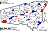
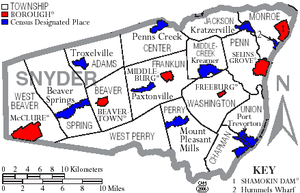
Port Trevorton is a census-designated place
(CDP) in Snyder County
, Pennsylvania
, United States
. The population was 451 at the 2000 census.
According to the United States Census Bureau
, the CDP has a total area of 2.8 square miles (7.3 km²), all of it land.
of 2000, there were 451 people, 166 households, and 118 families residing in the CDP. The population density
was 163.9 people per square mile (63.3/km²). There were 183 housing units at an average density of 66.5/sq mi (25.7/km²). The racial makeup of the CDP was 99.33% White, 0.22% African American, 0.22% Native American and 0.22% Asian. Hispanic or Latino of any race were 0.22% of the population.
There were 166 households out of which 32.5% had children under the age of 18 living with them, 59.6% were married couples
living together, 7.8% had a female householder with no husband present, and 28.9% were non-families. 25.9% of all households were made up of individuals and 12.0% had someone living alone who was 65 years of age or older. The average household size was 2.72 and the average family size was 3.32.
In the CDP the population was spread out with 30.2% under the age of 18, 9.5% from 18 to 24, 27.1% from 25 to 44, 21.7% from 45 to 64, and 11.5% who were 65 years of age or older. The median age was 33 years. For every 100 females there were 101.3 males. For every 100 females age 18 and over, there were 92.1 males.
The median income for a household in the CDP was $38,158, and the median income for a family was $40,625. Males had a median income of $31,458 versus $19,167 for females. The per capita income
for the CDP was $12,363. About 6.5% of families and 9.3% of the population were below the poverty line, including 14.4% of those under age 18 and 14.3% of those age 65 or over.
Municipal Building is located in Port Trevorton. The three Union Township Supervisors and Union Chapman Regional Authority provide local governance. Subdivisions are reviewed by Union Township Board of Supervisors and Snyder County Planning Commission and are approved by the Union Township Board of Supervisors. The Magisterial District Court is number 3.
The community's polling place is the Union Township Municipal Building.
Port Trevorton is in the 85th District of the Pennsylvania House of Representatives and the 27th Pennsylvania Senatorial District.
. Coal from the mines of the Zerbe Valley, near Trevorton
was shipped to the town via the Trevorton and Susquehanna Railroad, which was completed in 1855, crossing the Susquehanna River
on a long bridge
from Herndon
to Port Trevorton. A canal basin was built for coal loading from the railcars. However, a new route was built to the coal mines via Shamokin
, and the bridge was removed in 1870. As the fortunes of the canal declined, so too did those of the town.
Snyder County Historical Society 30 East Market St., Middleburg, PA.17842 570-837-6191 Museum and Library Research services are provided for a fee.
The State Library of Pennsylvania Commonwealth & Walnut Sts., Harrisburg, PA. This library provides information for State Government and citizens, collects and preserves Pennsylvania's written heritage through materials published for, by, and about Pennsylvania.
Census-designated place
A census-designated place is a concentration of population identified by the United States Census Bureau for statistical purposes. CDPs are delineated for each decennial census as the statistical counterparts of incorporated places such as cities, towns and villages...
(CDP) in Snyder County
Snyder County, Pennsylvania
Snyder County is a county located in the U.S. state of Pennsylvania. As of 2010, the population was 39,702. Snyder County was formed in 1855 from parts of Union County...
, Pennsylvania
Pennsylvania
The Commonwealth of Pennsylvania is a U.S. state that is located in the Northeastern and Mid-Atlantic regions of the United States. The state borders Delaware and Maryland to the south, West Virginia to the southwest, Ohio to the west, New York and Ontario, Canada, to the north, and New Jersey to...
, United States
United States
The United States of America is a federal constitutional republic comprising fifty states and a federal district...
. The population was 451 at the 2000 census.
Geography
Port Trevorton is located at 40°41′11"N 76°53′13"W (40.686397, -76.886956).According to the United States Census Bureau
United States Census Bureau
The United States Census Bureau is the government agency that is responsible for the United States Census. It also gathers other national demographic and economic data...
, the CDP has a total area of 2.8 square miles (7.3 km²), all of it land.
Demographics
As of the censusCensus
A census is the procedure of systematically acquiring and recording information about the members of a given population. It is a regularly occurring and official count of a particular population. The term is used mostly in connection with national population and housing censuses; other common...
of 2000, there were 451 people, 166 households, and 118 families residing in the CDP. The population density
Population density
Population density is a measurement of population per unit area or unit volume. It is frequently applied to living organisms, and particularly to humans...
was 163.9 people per square mile (63.3/km²). There were 183 housing units at an average density of 66.5/sq mi (25.7/km²). The racial makeup of the CDP was 99.33% White, 0.22% African American, 0.22% Native American and 0.22% Asian. Hispanic or Latino of any race were 0.22% of the population.
There were 166 households out of which 32.5% had children under the age of 18 living with them, 59.6% were married couples
Marriage
Marriage is a social union or legal contract between people that creates kinship. It is an institution in which interpersonal relationships, usually intimate and sexual, are acknowledged in a variety of ways, depending on the culture or subculture in which it is found...
living together, 7.8% had a female householder with no husband present, and 28.9% were non-families. 25.9% of all households were made up of individuals and 12.0% had someone living alone who was 65 years of age or older. The average household size was 2.72 and the average family size was 3.32.
In the CDP the population was spread out with 30.2% under the age of 18, 9.5% from 18 to 24, 27.1% from 25 to 44, 21.7% from 45 to 64, and 11.5% who were 65 years of age or older. The median age was 33 years. For every 100 females there were 101.3 males. For every 100 females age 18 and over, there were 92.1 males.
The median income for a household in the CDP was $38,158, and the median income for a family was $40,625. Males had a median income of $31,458 versus $19,167 for females. The per capita income
Per capita income
Per capita income or income per person is a measure of mean income within an economic aggregate, such as a country or city. It is calculated by taking a measure of all sources of income in the aggregate and dividing it by the total population...
for the CDP was $12,363. About 6.5% of families and 9.3% of the population were below the poverty line, including 14.4% of those under age 18 and 14.3% of those age 65 or over.
Government
The Union TownshipUnion Township, Snyder County, Pennsylvania
Union Township is a township in Snyder County, Pennsylvania, United States. The population was 1,519 at the 2000 census.-Geography:According to the United States Census Bureau, the township has a total area of 14.6 square miles , of which, 14.6 square miles of it is land and...
Municipal Building is located in Port Trevorton. The three Union Township Supervisors and Union Chapman Regional Authority provide local governance. Subdivisions are reviewed by Union Township Board of Supervisors and Snyder County Planning Commission and are approved by the Union Township Board of Supervisors. The Magisterial District Court is number 3.
The community's polling place is the Union Township Municipal Building.
Port Trevorton is in the 85th District of the Pennsylvania House of Representatives and the 27th Pennsylvania Senatorial District.
History
The name of the town comes from its days as a coal port on the Pennsylvania CanalPennsylvania Canal
Pennsylvania Canal refers generally to a complex system of canals, dams, locks, tow paths, aqueducts, and other infrastructure including, in some cases, railroads in Pennsylvania...
. Coal from the mines of the Zerbe Valley, near Trevorton
Trevorton, Pennsylvania
Trevorton is a community and census-designated place in Northumberland County, Pennsylvania, United States. The population was 2,010 at the 2000 census.-Geography:Trevorton is located at ....
was shipped to the town via the Trevorton and Susquehanna Railroad, which was completed in 1855, crossing the Susquehanna River
Susquehanna River
The Susquehanna River is a river located in the northeastern United States. At long, it is the longest river on the American east coast that drains into the Atlantic Ocean, and with its watershed it is the 16th largest river in the United States, and the longest river in the continental United...
on a long bridge
Trevorton Bridge
The Trevorton Bridge was a wooden covered bridge that crossed the Susquehanna River. It was erected between Herndon, Pennsylvania in Northumberland County and Port Trevorton in Snyder County. The bridge was long, with a trestle leading up to it...
from Herndon
Herndon, Pennsylvania
Herndon, formerly Trevorton Junction, is a borough in Northumberland County, Pennsylvania, United States. Herndon was first founded by Robert A. Parrish in 1840. The town was later named for Naval commander William Lewis Herndon, who died in 1857 while trying to rescue passengers from his sinking...
to Port Trevorton. A canal basin was built for coal loading from the railcars. However, a new route was built to the coal mines via Shamokin
Shamokin, Pennsylvania
Shamokin is a city in Northumberland County, Pennsylvania, at the western edge of the Anthracite Coal Region. At the 2000 census the population was 8,009 residents...
, and the bridge was removed in 1870. As the fortunes of the canal declined, so too did those of the town.
Libraries
The Selinsgrove Community Library is a public library that is part of the Snyder County Library system. Patrons have free use of the PA Power Library and Access Pennsylvania which provide extensive online resources for children and adults. The library is on the corner of High Street and Pine Street, one block west of Market Street in downtown Selinsgrove.Snyder County Historical Society 30 East Market St., Middleburg, PA.17842 570-837-6191 Museum and Library Research services are provided for a fee.
The State Library of Pennsylvania Commonwealth & Walnut Sts., Harrisburg, PA. This library provides information for State Government and citizens, collects and preserves Pennsylvania's written heritage through materials published for, by, and about Pennsylvania.