

Polar low
Encyclopedia
Low pressure area
A low-pressure area, or "low", is a region where the atmospheric pressure at sea level is below that of surrounding locations. Low-pressure systems form under areas of wind divergence which occur in upper levels of the troposphere. The formation process of a low-pressure area is known as...
(depression) that is found over the ocean areas poleward of the main polar front
Polar front
In meteorology, the polar front is the boundary between the polar cell and the Ferrel cell in each hemisphere. At this boundary a sharp gradient in temperature occurs between these two air masses, each at very different temperatures....
in both the Northern and Southern Hemispheres. The systems usually have a horizontal length scale of less than 1000 kilometres (621.4 mi) and exist for no more than a couple of days. They are part of the larger class of mesoscale
Mesoscale meteorology
Mesoscale meteorology is the study of weather systems smaller than synoptic scale systems but larger than microscale and storm-scale cumulus systems. Horizontal dimensions generally range from around 5 kilometers to several hundred kilometers...
weather systems. Polar lows can be difficult to detect using conventional weather reports and are a hazard to high-latitude operations, such as shipping and gas and oil platform
Oil platform
An oil platform, also referred to as an offshore platform or, somewhat incorrectly, oil rig, is a lаrge structure with facilities to drill wells, to extract and process oil and natural gas, and to temporarily store product until it can be brought to shore for refining and marketing...
s. Polar lows have been referred to by many other terms, such as polar mesoscale vortex, Arctic hurricane, Arctic low, and cold air depression. Today the term is usually reserved for the more vigorous systems that have near-surface winds of at least 17 m/s (38 mph).
History
Polar lows were first identified on the meteorological satellite imagery that became available in the 1960s, which revealed many small-scale cloud vortices at high latitudes. The most active polar lows are found over certain ice-free maritime areas in or near the ArcticArctic
The Arctic is a region located at the northern-most part of the Earth. The Arctic consists of the Arctic Ocean and parts of Canada, Russia, Greenland, the United States, Norway, Sweden, Finland, and Iceland. The Arctic region consists of a vast, ice-covered ocean, surrounded by treeless permafrost...
during the winter, such as the Norwegian Sea
Norwegian Sea
The Norwegian Sea is a marginal sea in the North Atlantic Ocean, northwest of Norway. It is located between the North Sea and the Greenland Sea and adjoins the North Atlantic Ocean to the west and the Barents Sea to the northeast. In the southwest, it is separated from the Atlantic Ocean by a...
, Barents Sea
Barents Sea
The Barents Sea is a marginal sea of the Arctic Ocean, located north of Norway and Russia. Known in the Middle Ages as the Murman Sea, the sea takes its current name from the Dutch navigator Willem Barents...
, Labrador Sea
Labrador Sea
The Labrador Sea is an arm of the North Atlantic Ocean between the Labrador Peninsula and Greenland. The sea is flanked by continental shelves to the southwest, northwest, and northeast. It connects to the north with Baffin Bay through the Davis Strait...
and Gulf of Alaska
Gulf of Alaska
The Gulf of Alaska is an arm of the Pacific Ocean defined by the curve of the southern coast of Alaska, stretching from the Alaska Peninsula and Kodiak Island in the west to the Alexander Archipelago in the east, where Glacier Bay and the Inside Passage are found.The entire shoreline of the Gulf is...
. Polar lows dissipate rapidly when they make landfall. Antarctic
Antarctic
The Antarctic is the region around the Earth's South Pole, opposite the Arctic region around the North Pole. The Antarctic comprises the continent of Antarctica and the ice shelves, waters and island territories in the Southern Ocean situated south of the Antarctic Convergence...
systems tend to be weaker than their northern counterparts since the air-sea temperature differences around the continent are generally smaller. However, vigorous polar lows can be found over the Southern Ocean
Southern Ocean
The Southern Ocean comprises the southernmost waters of the World Ocean, generally taken to be south of 60°S latitude and encircling Antarctica. It is usually regarded as the fourth-largest of the five principal oceanic divisions...
.
Structure
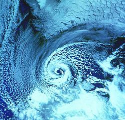
Polar lows can have a wide range of cloud signatures in satellite imagery, but two broad categories of cloud forms have been identified. The first is the "spiraliform" signature consisting of a number of cloud bands wrapped around the centre of the low. Some polar lows have the appearance in satellite imagery of tropical cyclones, with deep thunderstorm clouds surrounding a cloud-free ‘eyeEye (cyclone)
The eye is a region of mostly calm weather found at the center of strong tropical cyclones. The eye of a storm is a roughly circular area and typically 30–65 km in diameter. It is surrounded by the eyewall, a ring of towering thunderstorms where the second most severe weather of a cyclone...
’, which has given rise to the use of the term "Arctic hurricane" to describe some of the more active lows. These systems are more common deep within the polar air. The second is a "comma-shaped" signature that is found more frequently with systems closer to the polar front.
Formation
Polar lows form for a number of different reasons, and a spectrum of systems is observed on satellite imagery. A number of lows develop on horizontal temperature gradients through baroclinic instability, and these can have the appearance of small frontal depressions. At the other extreme are the polar lows with extensive cumulonimbus clouds, which are often associated with cold pools in the mid- to upper-troposphereTroposphere
The troposphere is the lowest portion of Earth's atmosphere. It contains approximately 80% of the atmosphere's mass and 99% of its water vapor and aerosols....
. During winter, when cold-core lows with temperatures in the mid-levels of the troposphere reach -45 C move over open waters, deep convection forms which allows polar low development to become possible.
Forecasting
Polar lows are very difficult to forecast and a nowcasting approach is often used, with the systems being advected with the mid-tropospheric flow. Numerical weather predictionNumerical weather prediction
Numerical weather prediction uses mathematical models of the atmosphere and oceans to predict the weather based on current weather conditions. Though first attempted in the 1920s, it was not until the advent of computer simulation in the 1950s that numerical weather predictions produced realistic...
models are only just getting the horizontal and vertical resolution to represent these systems.