
Pleasley
Encyclopedia
Pleasley is a small village in between the nearby towns of Chesterfield
and Mansfield
, it is 8 km south east of Bolsover
, Derbyshire
, England
and 4 km north west of Mansfield
, Nottinghamshire
. The River Meden
which forms the county boundary in this area runs through the village.
The bulk of the village is in the Derbyshire district of Bolsover, and constitutes a civil parish of the same name. The part in Nottinghamshire is in the district of Mansfield
and is unparished. Pleasley is not mentioned in Domesday
when it was part of Glapwell
parish.
. A new south window was fitted in the chancel at this time. The pulpit came from Derby cathedral, and there is a second font, which carries the date 1662. The building is a grade II* listed structure. It is situated close to the River Meden
which marks the county boundary and also the boundary of the ancient Sherwood Forest
.
George Sitwell
, Ironmaster
mined iron locally and at Pleasley he built a furnace, a forge and power saws in the seventeenth century.
Pleasley was a mining village for over 100 years. The Stanton Ironworks Company leased the mineral rights in 1872, and work on building the shaft for Pleasley Colliery
began soon afterwards. Stanton's continued to operate it until it was nationalised in 1946, after which it was run by the National Coal Board
until it closed in 1983. The mine was partly demolished but during the demolition it was realized that the pit winding engines were the only pair of such engines left. The former mine is now a museum. The spoil heaps have been turned into a large nature reserve, complete with large ponds, cycle and walking tracks. Pleasley, as a whole, covers two counties, a coal mine and an old cotton mill.
, which is still visible today. Between 1875-1899, two rows of terraced houses were built on what is now Old Terrace. These were built for workers at the colliery. Private bungalows were built along Terrace Lane, and in the 1920s, more pit houses were built on New Terrace, and along the top of Terrace Lane.
The terraced houses on Old Terrace were demolished in the 1970s, and the land stood empty for 30 years. In the early 2000s, this land was built on and a new estate was built, with two new cul-de-sacs being built, and new houses being built along Old Terrace. In 2009, the older houses on New Terrace were demolished, and the remaining houses renovated. New homes were built in the place of the demolished houses, following the existing road layout.
Residents are being moved out for demolition of the properties in seven phases. These phases are expected to last until 2013, as of May 2010 phase 1 is complete and phase 2 has commenced.
from Mansfield
leased the vale and Pleasley Park in 1782, in order to construct water-powered cotton mill
s. The Upper Mill was built first, on the site of the previous corn mill, and was operational by 1785. The Lower Mill was completed seven years later at a cost of £1,190, and was much bigger. A manager's house and a row of ten houses for the workers was also completed in 1792. The mills supplied cotton to the expanding East Midland hosiery
industry. One of the original three businessmen was Henry Hollins, and by the early 18th century, the mills were run by William Hollins and Co. They were the first and one of the most successful cotton producers in the East Midlands.
The Hollins family managed the mills for many years, but from the 1830s were joined by the Pagets, who introduced steam power to the mills. Fire destroyed the Upper Mill on 25 December 1840, but it was rebuilt by 1844. The Lower Mill also burnt down, and was replaced in 1847. Newer equipment fitted as part of the rebuilding enabled the mills to stay competitive. William Hollins lived at Pleasley Vale, and oversaw the expansion of the community, with the construction of more houses for the workers, the provision of public facilities including a school, wash house, and a cooperative society, and attention to leisure activities by the establishing of a Mechanics Institute
, a library and a cricket club. A company farm was also established. St Chad's Chapel and the vicarage were commissioned by Charles Paget in 1876. The Chapel was opened in 1881, but was reputedly built in 1861 at Stuffynwood, Derbyshire
, and later moved to its present site. It has a small bell turret at its western end, and a number of its features mimic thirteenth and fourteenth century styles. Internally, there is a brass memorial to Paget and his wife Helen Elizabeth.
From the 1890s, the mills produced Viyella, a mixture of cotton with Merino wool, which produces a soft fabric. A third mill (now called Mill 2) was built between the upper and lower mills in 1913. It was originally built as a combing
shed, where the cotton fibres were straightened and aligned prior to the production of fabric, but became a mill in 1952 following the addition of a further two floors to the main building, and a three-storey extension on the side. The mills continued to flourish, employing 980 workers at the site in 1934. Transport of raw materials and finished product was provided by the Midland Railway
, who opened their Tibshelf and Pleasley branch in 1883, primarily to serve Pleasley Colliery, which began production in 1878.Mansfield (2009), pp.13-16 The branch connected with other lines at Mansfield Woodhouse
in the east and Alfreton
in the west. Sidings and a warehouse were built below the lower mill. By 1938, the upper sidings had been built, which provided direct access to the Upper Mill and the combing shed. The railway and its sidings had both been dismantled by 1967.
The first workers houses were demolished in 1961, to be followed by the school, the baths and the Mechanics Institute. By 1987, production had moved abroad, and the mills closed. Bolsover District Council
sought to buy the mill buildings in 1992, using compulsory purchase powers. They were to be converted for use as offices and by light industry. The Council obtained them for just £1.00, and secured over £1 million in funding for the first phase of restoration. The initial building tackled was the latest to be built, and Mill 2 provided 160385 square feet (14,900.3 m²) of accommodation when it was completed in 1994. Phase 2 consisted of Mill 1 and the North Wing, which provided a further 130000 square feet (12,077.4 m³) and was completed in 1997. Stage 3 was the refurbishment of Mill 3, which provided 408646 square feet (37,964.5 m²) of space. By 1998, over £4 million had been spent of the work, and the mill buildings provided accommodation for 45 businesses employing 244 people.
Chesterfield
Chesterfield is a market town and a borough of Derbyshire, England. It lies north of Derby, on a confluence of the rivers Rother and Hipper. Its population is 70,260 , making it Derbyshire's largest town...
and Mansfield
Mansfield
Mansfield is a town in Nottinghamshire, England. It is the main town in the Mansfield local government district. Mansfield is a part of the Mansfield Urban Area....
, it is 8 km south east of Bolsover
Bolsover
Bolsover is a town near Chesterfield, Derbyshire, England. It is 145 miles from London, 18 miles from Sheffield, 26 miles from Nottingham and 54 miles from Manchester. It is the main town in the Bolsover district.The civil parish for the town is called...
, Derbyshire
Derbyshire
Derbyshire is a county in the East Midlands of England. A substantial portion of the Peak District National Park lies within Derbyshire. The northern part of Derbyshire overlaps with the Pennines, a famous chain of hills and mountains. The county contains within its boundary of approx...
, England
England
England is a country that is part of the United Kingdom. It shares land borders with Scotland to the north and Wales to the west; the Irish Sea is to the north west, the Celtic Sea to the south west, with the North Sea to the east and the English Channel to the south separating it from continental...
and 4 km north west of Mansfield
Mansfield
Mansfield is a town in Nottinghamshire, England. It is the main town in the Mansfield local government district. Mansfield is a part of the Mansfield Urban Area....
, Nottinghamshire
Nottinghamshire
Nottinghamshire is a county in the East Midlands of England, bordering South Yorkshire to the north-west, Lincolnshire to the east, Leicestershire to the south, and Derbyshire to the west...
. The River Meden
River Meden
The River Meden is a river in Nottinghamshire, England. Its source lies just north of Huthwaite, near the Derbyshire border, and from there it flows north east through Pleasley and Warsop before merging temporarily with the River Maun near Bothamsall...
which forms the county boundary in this area runs through the village.
The bulk of the village is in the Derbyshire district of Bolsover, and constitutes a civil parish of the same name. The part in Nottinghamshire is in the district of Mansfield
Mansfield (district)
Mansfield is a local government district in Nottinghamshire, England. According to the 2001 UK census, its population was 98,181.Unlike most English districts, its council is led by a directly elected mayor, currently Tony Egginton, an independent...
and is unparished. Pleasley is not mentioned in Domesday
Domesday Book
Domesday Book , now held at The National Archives, Kew, Richmond upon Thames in South West London, is the record of the great survey of much of England and parts of Wales completed in 1086...
when it was part of Glapwell
Glapwell
Glapwell is located in north east Derbyshire between the nearby towns of Chesterfield and Mansfield , although the nearest town centre is that of Bolsover . It is a village of 1,467 residents, situated on a hill adjoining the village of Bramley Vale.-History:This village is listed in the...
parish.
Buildings
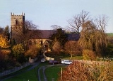
The parish church of St. Michael is built of squared sandstone and is believed to originate from the 12th century, as it includes a 12th century chancel arch and font. There are also features from the 13th and 14th century, end evidence of significant restoration in the 19th century, when it was re-roofed in Welsh slateSlate
Slate is a fine-grained, foliated, homogeneous metamorphic rock derived from an original shale-type sedimentary rock composed of clay or volcanic ash through low-grade regional metamorphism. The result is a foliated rock in which the foliation may not correspond to the original sedimentary layering...
. A new south window was fitted in the chancel at this time. The pulpit came from Derby cathedral, and there is a second font, which carries the date 1662. The building is a grade II* listed structure. It is situated close to the River Meden
River Meden
The River Meden is a river in Nottinghamshire, England. Its source lies just north of Huthwaite, near the Derbyshire border, and from there it flows north east through Pleasley and Warsop before merging temporarily with the River Maun near Bothamsall...
which marks the county boundary and also the boundary of the ancient Sherwood Forest
Sherwood Forest
Sherwood Forest is a Royal Forest in Nottinghamshire, England, that is famous through its historical association with the legend of Robin Hood. Continuously forested since the end of the Ice Age, Sherwood Forest National Nature Reserve today encompasses 423 hectares surrounding the village of...
.
George Sitwell
George Sitwell (Sheriff)
George Sitwell was the leading ironmaster in North Derbyshire and North Nottinghamshire in the seventeenth century.. He built Renishaw Hall in Derbyshire in 1626. He mined, forged, and rolled iron for use in Britain and overseas...
, Ironmaster
Ironmaster
An ironmaster is the manager – and usually owner – of a forge or blast furnace for the processing of iron. It is a term mainly associated with the period of the Industrial Revolution, especially in Great Britain....
mined iron locally and at Pleasley he built a furnace, a forge and power saws in the seventeenth century.
Pleasley was a mining village for over 100 years. The Stanton Ironworks Company leased the mineral rights in 1872, and work on building the shaft for Pleasley Colliery
Pleasley Colliery
Pleasley Colliery is a former English coal mine. It is located to the NW of Pleasley village which sits astride the River Meden on the Nottinghamshire/Derbyshire border....
began soon afterwards. Stanton's continued to operate it until it was nationalised in 1946, after which it was run by the National Coal Board
National Coal Board
The National Coal Board was the statutory corporation created to run the nationalised coal mining industry in the United Kingdom. Set up under the Coal Industry Nationalisation Act 1946, it took over the mines on "vesting day", 1 January 1947...
until it closed in 1983. The mine was partly demolished but during the demolition it was realized that the pit winding engines were the only pair of such engines left. The former mine is now a museum. The spoil heaps have been turned into a large nature reserve, complete with large ponds, cycle and walking tracks. Pleasley, as a whole, covers two counties, a coal mine and an old cotton mill.
The constituencies of Pleasley
The area of Pleasley itself consists of four distinct areas: Pleasley Village, Pleasley Vale, Pleasley Hill and Upper Pleasley.Upper Pleasley
Upper Pleasley is situated at the southern end of the village, and is today the area around Terrace Lane. Terrace Lane was initially surrounded by fields, and eventually served as the back entrance to Pleasley CollieryPleasley Colliery
Pleasley Colliery is a former English coal mine. It is located to the NW of Pleasley village which sits astride the River Meden on the Nottinghamshire/Derbyshire border....
, which is still visible today. Between 1875-1899, two rows of terraced houses were built on what is now Old Terrace. These were built for workers at the colliery. Private bungalows were built along Terrace Lane, and in the 1920s, more pit houses were built on New Terrace, and along the top of Terrace Lane.
The terraced houses on Old Terrace were demolished in the 1970s, and the land stood empty for 30 years. In the early 2000s, this land was built on and a new estate was built, with two new cul-de-sacs being built, and new houses being built along Old Terrace. In 2009, the older houses on New Terrace were demolished, and the remaining houses renovated. New homes were built in the place of the demolished houses, following the existing road layout.
Pleasley Hill
Pleasley Hill consists of rows of derelict terraced houses running along the main road into Mansfield, and is strictly part of Mansfield. These have long been the subject of debate in the area, and are currently undergoing a scheme to demolish them and replace them with parkland, open spaces and residential housing.Residents are being moved out for demolition of the properties in seven phases. These phases are expected to last until 2013, as of May 2010 phase 1 is complete and phase 2 has commenced.
Pleasley Vale
Pleasley Vale is a deep, narrow valley, much of which is wooded, which has been formed by the River Meden cutting down through the underlying limestone escarpment. The Vale has been the location for industry since at least 1767, when two forges and a corn mill are known to have been operating, powered by the river. The forges were run by George Sitwell, and were called Nether and Upper forge. The engineered river channel made it a good site for further development, and a consortium of businessmen from Nottingham and drapersDrapery
Drapery is a general word referring to cloths or textiles . It may refer to cloth used for decorative purposes – such as around windows – or to the trade of retailing cloth, originally mostly for clothing, formerly conducted by drapers.In art history, drapery refers to any cloth or...
from Mansfield
Mansfield
Mansfield is a town in Nottinghamshire, England. It is the main town in the Mansfield local government district. Mansfield is a part of the Mansfield Urban Area....
leased the vale and Pleasley Park in 1782, in order to construct water-powered cotton mill
Cotton mill
A cotton mill is a factory that houses spinning and weaving machinery. Typically built between 1775 and 1930, mills spun cotton which was an important product during the Industrial Revolution....
s. The Upper Mill was built first, on the site of the previous corn mill, and was operational by 1785. The Lower Mill was completed seven years later at a cost of £1,190, and was much bigger. A manager's house and a row of ten houses for the workers was also completed in 1792. The mills supplied cotton to the expanding East Midland hosiery
Hosiery
Hosiery, also referred to as legwear, describes garments worn directly on the feet and legs. The term originated as the collective term for products of which a maker or seller is termed a hosier; and those products are also known generically as hose...
industry. One of the original three businessmen was Henry Hollins, and by the early 18th century, the mills were run by William Hollins and Co. They were the first and one of the most successful cotton producers in the East Midlands.
The Hollins family managed the mills for many years, but from the 1830s were joined by the Pagets, who introduced steam power to the mills. Fire destroyed the Upper Mill on 25 December 1840, but it was rebuilt by 1844. The Lower Mill also burnt down, and was replaced in 1847. Newer equipment fitted as part of the rebuilding enabled the mills to stay competitive. William Hollins lived at Pleasley Vale, and oversaw the expansion of the community, with the construction of more houses for the workers, the provision of public facilities including a school, wash house, and a cooperative society, and attention to leisure activities by the establishing of a Mechanics Institute
Mechanics' Institutes
Historically, Mechanics' Institutes were educational establishments formed to provide adult education, particularly in technical subjects, to working men...
, a library and a cricket club. A company farm was also established. St Chad's Chapel and the vicarage were commissioned by Charles Paget in 1876. The Chapel was opened in 1881, but was reputedly built in 1861 at Stuffynwood, Derbyshire
Derbyshire
Derbyshire is a county in the East Midlands of England. A substantial portion of the Peak District National Park lies within Derbyshire. The northern part of Derbyshire overlaps with the Pennines, a famous chain of hills and mountains. The county contains within its boundary of approx...
, and later moved to its present site. It has a small bell turret at its western end, and a number of its features mimic thirteenth and fourteenth century styles. Internally, there is a brass memorial to Paget and his wife Helen Elizabeth.
From the 1890s, the mills produced Viyella, a mixture of cotton with Merino wool, which produces a soft fabric. A third mill (now called Mill 2) was built between the upper and lower mills in 1913. It was originally built as a combing
Combing
Combing is a method for preparing carded fibre for spinning. It separates out the short fibres by means of a rotating ring of steel pins. The fibres in the 'top' it produces, have been straightened and lie parallel to each other...
shed, where the cotton fibres were straightened and aligned prior to the production of fabric, but became a mill in 1952 following the addition of a further two floors to the main building, and a three-storey extension on the side. The mills continued to flourish, employing 980 workers at the site in 1934. Transport of raw materials and finished product was provided by the Midland Railway
Midland Railway
The Midland Railway was a railway company in the United Kingdom from 1844 to 1922, when it became part of the London, Midland and Scottish Railway....
, who opened their Tibshelf and Pleasley branch in 1883, primarily to serve Pleasley Colliery, which began production in 1878.Mansfield (2009), pp.13-16 The branch connected with other lines at Mansfield Woodhouse
Mansfield Woodhouse
Mansfield Woodhouse is a large village about 2 kilometres north of Mansfield itself, in Nottinghamshire, England. With a history dating back before the Romans, it is still noteworthy for its stone built town centre...
in the east and Alfreton
Alfreton
Alfreton is a town and civil parish in Amber Valley, Derbyshire, England, adjoining the Bolsover and North East Derbyshire districts. It was formerly a Norman Manor and later an Urban District. The population of the Alfreton Ward was 7,928 at the 2001 Census...
in the west. Sidings and a warehouse were built below the lower mill. By 1938, the upper sidings had been built, which provided direct access to the Upper Mill and the combing shed. The railway and its sidings had both been dismantled by 1967.
The first workers houses were demolished in 1961, to be followed by the school, the baths and the Mechanics Institute. By 1987, production had moved abroad, and the mills closed. Bolsover District Council
Bolsover (district)
Bolsover is a local government district in Derbyshire, England. Its main town is Bolsover.There are fourteen town and parish councils within the district.In addition to the town councils of Old Bolsover and Shirebrook, there are the parish councils of:...
sought to buy the mill buildings in 1992, using compulsory purchase powers. They were to be converted for use as offices and by light industry. The Council obtained them for just £1.00, and secured over £1 million in funding for the first phase of restoration. The initial building tackled was the latest to be built, and Mill 2 provided 160385 square feet (14,900.3 m²) of accommodation when it was completed in 1994. Phase 2 consisted of Mill 1 and the North Wing, which provided a further 130000 square feet (12,077.4 m³) and was completed in 1997. Stage 3 was the refurbishment of Mill 3, which provided 408646 square feet (37,964.5 m²) of space. By 1998, over £4 million had been spent of the work, and the mill buildings provided accommodation for 45 businesses employing 244 people.
Scarecrow Festival
The village held a scarecrow festival in June 2010. Visitors to the event were given a map of the village and then voted for which one they thought was best.External links
- http://pleasleyparishcouncil.org.uk/
- http://pleasleyhillplight.wordpress.com/
- http://www.pleasley-colliery.org.uk
- http://www.pleasleylandmark.co.uk