

Piva River
Encyclopedia
The Piva is a river in Montenegro
and Bosnia and Herzegovina
, shorter headwater of the Drina
river, which it forms with the Tara river on the border with Bosnia and Herzegovina.
mountain, near the Piva Monastery
(also called Vrelo Pive; Cyrillic: Врело Пиве; Well of Piva). Before the artificial Lake Piva was formed, the water from the well rushed into the river Komarnica (Cyrillic: Комарница) thus creating the Piva river for the next 34 km. However, Komarnica is part of a 86 km long river system (Tušina-Bukovica-Bijela-Komarnica), so measured from the source of the Tušina river (Cyrillic: Тушина), the Piva, nicknamed 'the river with five names' is 120 km long.
The Tušina originates from the mountain Sinjajevina in the Uskoci region of central Montenegro, just few kilometers away from the source of another important Montenegrin river, Morača. The river flows to the west, between the Sinjajevina and Lola mountains, next to the villages of Krnja Jela, Bare, Boan and Tušina. It receives from the north the Bukovica river (Cyrillic: Буковица), and continues further under this name. After the river passes the regional center of Šavnik
and the villages of Gradac and Pridvorica in the region of Drobnjaci
, the stream receives from the north the Komarnica and takes its name.
 The Komarnica continues between the mountains of Vojnik and Treskavac
, in an almost uninhabited area (village of Duži) and enters the high Piva Pleateau, where it turns north (almost all of the Komarnica's course is flooded by the reservoir of the Lake Piva), receives from the right outflow of the Piva well and enters the deep Piva canyon.
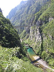
The canyon is cut between the mountains of Bioč
, Volujak
, Maglić
and Pivska planina, its 33 km long, deep up to 1.200 m and river generates immense power used for the power station of Mratinje
(342 MW) which dammed the canyon in 1975. The dam is 220 m high, one of the highest in Europe
and creates Lake Piva, third largest in Serbia and Montenegro (12,5 km², altitude 675 m, 188 m deep), which flooded the old location of the monastery of Piva from the 16th century, so the monastery was moved to the new one. The Vrbnica river flows from the left into the lake.
After the dam, the Piva continues straight to the north, meets the Tara at Šćepan Polje
on the border with Bosnia and Herzegovina and creates the Drina.
The Piva belongs to the Black Sea
drainage basin
with its own drainage area of 1.270 km² and is not navigable.
, Maglić, Lebršnik
, Golija and Vojnik. The plateau is 55 km long, 30 km wide with an average altitude of 1.200 m, the highest 2.159 m. The flow of Komarnica-Piva divides it in two regions: western one, Pivska Župa (Cyrillic: Пивска Жупа) and eastern one, Pivska planina (Cyrillic: Пивска планина). Area is characterized by many limestone features, like cavities (called vrtača, вртача) deep pits and excavations, and extremely sparsely populated (some 20 smaller settlements in Pivska Župa and 15 in Pivska planina).
Stock breeding is developed though, especially sheep.
Montenegro
Montenegro Montenegrin: Crna Gora Црна Гора , meaning "Black Mountain") is a country located in Southeastern Europe. It has a coast on the Adriatic Sea to the south-west and is bordered by Croatia to the west, Bosnia and Herzegovina to the northwest, Serbia to the northeast and Albania to the...
and Bosnia and Herzegovina
Bosnia and Herzegovina
Bosnia and Herzegovina , sometimes called Bosnia-Herzegovina or simply Bosnia, is a country in Southern Europe, on the Balkan Peninsula. Bordered by Croatia to the north, west and south, Serbia to the east, and Montenegro to the southeast, Bosnia and Herzegovina is almost landlocked, except for the...
, shorter headwater of the Drina
Drina
The Drina is a 346 kilometer long river, which forms most of the border between Bosnia and Herzegovina and Serbia. It is the longest tributary of the Sava River and the longest karst river in the Dinaric Alps which belongs to the Danube river watershed...
river, which it forms with the Tara river on the border with Bosnia and Herzegovina.
Course
The Piva springs from the Sinjac (Cyrillic: Сињац) spring on GolijaGolija
Golija is a mountain in southwestern Serbia, between towns of Ivanjica and Novi Pazar. It belongs to the Dinaric mountain range. The mountain is heavily forested, with significant biodiversity and it hosts the Golija-Studenica Biosphere Reserve, the first UNESCO-MAB registered biosphere reserve in...
mountain, near the Piva Monastery
Piva Monastery
Piva Monastery is located in Piva, Montenegro near the source of the Piva River in northern Montenegro. Built between 1573 and 1586, it was rebuilt in another location in 1982...
(also called Vrelo Pive; Cyrillic: Врело Пиве; Well of Piva). Before the artificial Lake Piva was formed, the water from the well rushed into the river Komarnica (Cyrillic: Комарница) thus creating the Piva river for the next 34 km. However, Komarnica is part of a 86 km long river system (Tušina-Bukovica-Bijela-Komarnica), so measured from the source of the Tušina river (Cyrillic: Тушина), the Piva, nicknamed 'the river with five names' is 120 km long.
The Tušina originates from the mountain Sinjajevina in the Uskoci region of central Montenegro, just few kilometers away from the source of another important Montenegrin river, Morača. The river flows to the west, between the Sinjajevina and Lola mountains, next to the villages of Krnja Jela, Bare, Boan and Tušina. It receives from the north the Bukovica river (Cyrillic: Буковица), and continues further under this name. After the river passes the regional center of Šavnik
Šavnik
Šavnik is a small town in northern Montenegro. It has a population of 570 .Šavnik is the centre of the municipality and unofficial centre of Drobnjaci region, home of the Drobnjaci tribe....
and the villages of Gradac and Pridvorica in the region of Drobnjaci
Drobnjaci
Drobnjaci is an Old Herzegovinian clan and region in northern Montenegro . Its unofficial centre is in Boan/Šavnik. The Drobnjaci families are predominantly Serb Orthodox, with a majority declaring as Serbs, the rest as Montenegrins...
, the stream receives from the north the Komarnica and takes its name.
Treskavac
Treskavac is a village in the municipality of Ključ, Bosnia and Herzegovina....
, in an almost uninhabited area (village of Duži) and enters the high Piva Pleateau, where it turns north (almost all of the Komarnica's course is flooded by the reservoir of the Lake Piva), receives from the right outflow of the Piva well and enters the deep Piva canyon.
The canyon is cut between the mountains of Bioč
Bioč
Bioč is a mountain within the Sutjeska National Park, Republic of Srpska, Bosnia and Herzegovina. It has an altitude of 2,388 metres , and lies on the border with Montenegro.The Piva runs nearby....
, Volujak
Volujak
Volujak is a peak of the Prokletije range in Kosovo, reaching a top height of . Volujak creates part of the Rugova Canyon. This mountain can be seen from the city of Peć because it is only a few kilometers west of it.-Notes and references:Notes:...
, Maglić
Maglic
Maglič is a medieval fortress in Ibar gorge 20 km south from Kraljevo in Serbia. It is placed atop a hill around which the Ibar River makes a curve, about 100 m above river level. The fortress protected the only caravan road that connected the Morava Valley and Kosovo polje...
and Pivska planina, its 33 km long, deep up to 1.200 m and river generates immense power used for the power station of Mratinje
Mratinje Dam
The Mratinje Dam is a concrete arch dam in the canyon of the Piva River in Montenegro.The dam was completed in 1975 with designs by Energoprojekt. Its construction resulted in the flooding of the Piva canyon and the creation of Lake Piva, which, with its 12.5 km², is the second largest lake in...
(342 MW) which dammed the canyon in 1975. The dam is 220 m high, one of the highest in Europe
Europe
Europe is, by convention, one of the world's seven continents. Comprising the westernmost peninsula of Eurasia, Europe is generally 'divided' from Asia to its east by the watershed divides of the Ural and Caucasus Mountains, the Ural River, the Caspian and Black Seas, and the waterways connecting...
and creates Lake Piva, third largest in Serbia and Montenegro (12,5 km², altitude 675 m, 188 m deep), which flooded the old location of the monastery of Piva from the 16th century, so the monastery was moved to the new one. The Vrbnica river flows from the left into the lake.
After the dam, the Piva continues straight to the north, meets the Tara at Šćepan Polje
Šćepan Polje
Šćepan Polje is a village in Montenegro. It is border crossing point between Montenegro and Bosnia and Herzegovina, where the River Drina forms the border between the two countries. The village across the border is Hum....
on the border with Bosnia and Herzegovina and creates the Drina.
The Piva belongs to the Black Sea
Black Sea
The Black Sea is bounded by Europe, Anatolia and the Caucasus and is ultimately connected to the Atlantic Ocean via the Mediterranean and the Aegean seas and various straits. The Bosphorus strait connects it to the Sea of Marmara, and the strait of the Dardanelles connects that sea to the Aegean...
drainage basin
Drainage basin
A drainage basin is an extent or an area of land where surface water from rain and melting snow or ice converges to a single point, usually the exit of the basin, where the waters join another waterbody, such as a river, lake, reservoir, estuary, wetland, sea, or ocean...
with its own drainage area of 1.270 km² and is not navigable.
Piva Plateau
Pivska površ (Cyrillic: Пивска површ), is a high limestone plateau in the drainage area of Piva, between the mountains of DurmitorDurmitor
Durmitor is a massif and the name of a national park in North Western Montenegro. It reaches a height of 2,522 m .The massif is bordered by Tara River Canyon on the North, Piva River Canyon on the West, and by Komarnica River Canyon on the South. To the East, Durmitor is open to a vast ...
, Maglić, Lebršnik
Lebršnik
Lebršnik is a mountain in the municipality of Gacko, Bosnia and Herzegovina. It has an altitude of ....
, Golija and Vojnik. The plateau is 55 km long, 30 km wide with an average altitude of 1.200 m, the highest 2.159 m. The flow of Komarnica-Piva divides it in two regions: western one, Pivska Župa (Cyrillic: Пивска Жупа) and eastern one, Pivska planina (Cyrillic: Пивска планина). Area is characterized by many limestone features, like cavities (called vrtača, вртача) deep pits and excavations, and extremely sparsely populated (some 20 smaller settlements in Pivska Župa and 15 in Pivska planina).
Stock breeding is developed though, especially sheep.