
Drina
Encyclopedia
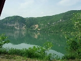
The Drina is a 346 kilometer long river, which forms most of the border between Bosnia and Herzegovina
and Serbia
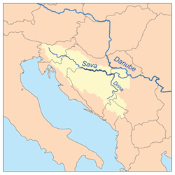
. It is the longest tributary of the Sava River
and the longest karst
river in the Dinaric Alps
which belongs to the Danube
river watershed. Its name is derived from the Latin
name of the river which in turn is derived from Greek
(Ancient Greek
: ).
and converge on the border of Bosnia and Herzegovina
, at Hum and Šćepan Polje
villages. The total length of the Tara river is 144 km, of which 110 km are in Montenegro
, while the final 34 km are in Bosnia and Herzegovina
along which form the border between the two countries in several places. The Drina flows through Bosnia and Herzegovina
northward for 346 kilometers, of which 206 kilometers (128 mi) is along the border of Bosnia and Herzegovina
and Serbia
, and finally spills out into the Sava river near Bosanska Rača village in northeastern Bosnia and Herzegovina
. Measured from the source of the Tara, its longer headwater, the Drina is 487 kilometers (303 mi) long.
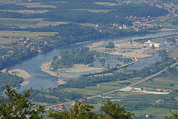
The river is not navigable; however, together with the Tara it represents the main kayaking
and rafting
attraction in Bosnia and Herzegovina and Montenegro, indeed whole Balkans
.
 The Drina originates between the slopes of the Maglić
and Pivska planina mountains, between the villages of Šćepan Polje (in Montenegro) and Hum (Bosnia and Herzegovina). At its origin, it flows west, then makes a large curve to the northeast, around the Maluša mountains. Next, it flows through the villages of Kosman, Prijedjel, Dučeli, Čelikovo Polje, Kopilovi, Trbušće, Brod and the town of Foča
. It receives the Sutjeska, Bjelava and Bistrica rivers from the left and the Ćehotina at Foča from the right.
Here the Drina carved the longest one of the several gorges on its course, the 45 kilometer (28 mi)-long Suhi Dol-Biserovina gorge between the southernmost slopes of the Jahorina
mountains from the north and the Kovač mountains from the south. The villages of Zlatari, Jošanica, Ustikolina, Cvilin, Zebina Šuma, Osanica, Kolovarice, Vranići, Mravinjac, Biljin, Vitkovići
and Zupčići are located in the gorge, as well as the town of Goražde
. The river receives the Kolunska rijeka and the Osanica as tributaries from the left.
The Drina continues to the northeast, flowing close to the villages of Žuželo, Odžak, Kopači and Ustiprača, entering the 26 km (16 mi) long Međeđa gorge carved between the Vučevica
mountains from the south and the southern slopes of the Devetak
mountains from the north. The narrowest part of the Međeđa gorge is Tijesno, the 8 kilometer (5 mi)-long section of the gorge where the river is at its narrowest (only 12 meters (39 ft) wide), but also at its deepest (12 m). Here it receives the Prača river from the left and the Janjina and Lim rivers from the right. The villages of Trbosilje, Međeđa and Orahovci are located in the gorge, which is for the most part flooded by the artificial Višegrad lake, created by the Višegrad hydro electric power plant.
 At the town of Višegrad
, the Drina receives the Rzav River from the right and turns northwest at the Suva Gora mountain into the Klotijevac gorge. The gorge is 38 kilometers (24 mi) long and up to 1 kilometer (3,200 ft) deep, carved between the mountains of Bokšanica (from the west) and Zvijezda (from the east). The villages of Sase, Resnik, Đurevići and Gornje Štitarevo lie in the gorge and the Kukal river flows into the Drina from the right. At the Slap village, the Drina receives the Žepa
river from the right and turns sharply to the west, becoming a border river between Bosnia and Herzegovina and Serbia near the village of Jagoštica.
and it is flooded by the artificial Lake Perućac on the northern slopes of the Tara
mountain, created by the Bajina Bašta power plant. The villages of Prohići and Osatica (in Bosnia and Herzegovina) are located on the lake, as well as the ruins of the medieval town of Đurđevac. The river is dammed at the village of Perućac
, where a strong well springs out from the Tara mountain, flowing into the Drina as a waterfall. In addition, the waters of Drina are used for several fish pond
s for the California trout
spawning.
The river continues to the villages of Peći, Dobrak, Skelani (in Bosnia and Herzegovina) and Zaguline (in Serbia), reaching the town of Bajina Bašta
. At the villages of Donja Crvica and Rogačica, the Drina makes a large turn, completely changing its direction from the northeast to the northwest. This distinct geographical feature forms the Osat
and Ludmer regions of Republika Srpska, Bosnia and Herzegovina, which are separated by the river from the Azbukovica part of the Podrinje region of Serbia.
mountain, the Drina passes next to the villages of Gvozdac, Okletac, Strmovo, Bačevci, Donje Košlje, Drlače, Vrhpolje, Donja Bukovica (in Serbia), Boljevići, Fakovići, Tegare, Sikirići and Voljevica (in Bosnia and Herzegovina), before it reaches the towns of Ljubovija
in Serbia, the center of the Azbukovica (or Upper Podrinje) region, and Bratunac
, in Bosnia and Herzegovina, the center of the Ludmer region. Here the Drina receives the right tributary of Ljuboviđa and continues between the mountains of Jagodnja
and Boranja
(in Serbia), and Glogova
(in Bosnia and Herzegovina). After the ruins of the medieval town of Mikuljak and the villages of Mičići, Uzovnica, Crnča, Voljevci (in Serbia), Krasanovići, Dubravice, Polom and Zelinje (in Bosnia and Herzegovina), the Drina is flooded again, this time by the artificial Lake Zvornik, as a result of the Zvornik power plant. The villages of Amajic, Culine (in Serbia), Sopotnik, Drinjača and Djevanje (in Bosnia and Herzegovina) are located on the lake. This is also where the Drinjača
river flows into the Drina (now the Zvornik lake) from the left, flowing from the Bosnian region of Gornji Birač.
 After the dual town of Zvornik
(Bosnia and Herzegovina)-Mali Zvornik
(Serbia), the Drina flows between the Bosnian mountain of Majevica
and the Serbian mountain of Gučevo
, and enters the Lower Podrinje region. For the rest of its flow after the village of Kozluk, it has no major settlements on the Bosnian side (except for the town of Janja
, which is several kilometers away from the river, and some smaller settlements, like Branjevo and Glavičice). On the Serbian side, the Drina passes next to the villages of Brasina and Rečane, the ruins of the medieval town of Koviljkin grad
, the spa
and town of Banja Koviljača
, the industrial town and center of the Podrinje region, Loznica, and its largest suburb, Lozničko Polje
.
(where it receives the Jadar
river) and Iverak (where it receives the Lešnica). This is where the rivers spills in many arms and flows, creating the largest flood plain in former Yugoslavia
, which the river divides in half. The east side, Mačva
, is in Serbia, and the west side, Semberija
, in Bosnia and Herzegovina (where it receives the Janja river). The Drina spills over and meanders, forming shallows, islands and sandbars, before emptying into the Sava river between the Serbian village of Crna Bara
and the Bosnian Bosanska Rača. The variability of the water flow and low altitude resulted in several course changes during history. The Drina previously flowed into the Sava river near Šabac
, 30 kilometers (18 mi) to the east of the present mouth.
, the Drina is also a meandering river, with a very high meandering ratio (175:346), still slightly less than that of Velika Morava.
The Drina is a very fast river with cold and greenish water, which is from the limestone
that underlays the area in which the river carved its bed.
Its average depth is 3 to 5 meters (10–15 ft), the deepest being 12 meters (40 ft) at Tijesno. On average, the Drina is 50–60 meters (160–200 ft) wide, but it ranges from only 12–20 meters (40–65 ft) at Tijesno to up to 200 meters (650 ft) at Bajina Bašta
and Ljubovija
.
The drainage basin covers 19,570 square kilometers (4.8 million acres), branching into Bosnia and Herzegovina, Serbia, Montenegro, and Albania
. The Drina belongs to the Black Sea
drainage basin
.
Before it was regulated by the several power stations, the Drina used to flood its valley. The most disastrous flood occurred in 1896, which destroyed the town of Ljubovija
.
(at Kosman), Bjelava (at Trbušće), Bistrica (at Brod), Kolunska rijeka (at Ustikolina
), Osanica (at Osanica), Prača (at Ustiprača), Žepa
(at Slap), Drinjača
(at Drinjača), Kamenica (at Djevanje), Sapna (at Karakaja) and Janja (at Janja
).
Major right tributaries: Ćehotina (at Foča
), Janjina (at Samobor), Lim
(the longest one, 220 km, at Brodar), Rzav
(at Višegrad
), Kukal (at Đurevići), Rogačica (at Rogačica), Trešnjica (south of Ljubovija
), Ljuboviđa (at Ljubovija
), Jadar
(at Straža) and Lešnica (at Lešnica
).
Also, the discharge steadily grows: 125 cubic meters per second (4,400 cu.ft./s) at the Ćehotina's mouth, and 370 cubic meters per second (13,000 cu.ft./s) on the Drina's mouth into the Sava.
However, power capacity is not fully used since only three hydro electrical power stations (HE) have been constructed so far: HE Zvornik, HE Bajina Bašta, and HE Višegrad.
The Drina is crossed by several bridges: at Višegrad, Skelani
, Bratunac and Zvornik (in Bosnia and Herzegovina), and Loznica and Badovinci in Serbia. The most recent bridge is the one at Badovinci, the Pavlovića ćuprija.
and Serbian languages as a phrase used when someone wants to resolve a complicated situation; it is said that he or she wants to "straighten the bent Drina".
During World War I
, from September 8 to September 16, 1914, the Drina was the battlefield of a bloody battle between the Serbian and Austro-Hungarian
army, the Battle of Cer
. In honor of the battle, the Serbian composer Stanislav Binički
(1872–1942) composed the famous March on the Drina
, and in 1964 a movie of the same title was shot by director Žika Mitrović
. The movie was later banned for a period of time by the Communist government, because of its portrayal of a true-to-life, bloody battle, and its use of Binički's march (banned at that time) as part of the soundtrack. The Slovenian band Laibach
did a cover version of the March on the Drina titled Mars on the River Drina in their album NATO
, released in 1994 during the Yugoslav Wars
.
The largest impact the river has had in culture probably is the novel "Na Drini ćuprija
" (The Bridge on the Drina
) by the Nobel Prize
laureate, Ivo Andrić
; the book is about the building of a bridge
near Višegrad by the Ottomans
in the 16th century
Bosnia and Herzegovina
Bosnia and Herzegovina , sometimes called Bosnia-Herzegovina or simply Bosnia, is a country in Southern Europe, on the Balkan Peninsula. Bordered by Croatia to the north, west and south, Serbia to the east, and Montenegro to the southeast, Bosnia and Herzegovina is almost landlocked, except for the...
and Serbia
Serbia
Serbia , officially the Republic of Serbia , is a landlocked country located at the crossroads of Central and Southeast Europe, covering the southern part of the Carpathian basin and the central part of the Balkans...
. It is the longest tributary of the Sava River
Sava River
The Sava is a river in Southeast Europe, a right side tributary of the Danube river at Belgrade. Counting from Zelenci, the source of Sava Dolinka, it is long and drains of surface area. It flows through Slovenia, Croatia, along the northern border of Bosnia and Herzegovina, and through Serbia....
and the longest karst
KARST
Kilometer-square Area Radio Synthesis Telescope is a Chinese telescope project to which FAST is a forerunner. KARST is a set of large spherical reflectors on karst landforms, which are bowlshaped limestone sinkholes named after the Kras region in Slovenia and Northern Italy. It will consist of...
river in the Dinaric Alps
Dinaric Alps
The Dinaric Alps or Dinarides form a mountain chain in Southern Europe, spanning areas of Slovenia, Croatia, Bosnia and Herzegovina, Serbia, Kosovo, Albania and Montenegro....
which belongs to the Danube
Danube
The Danube is a river in the Central Europe and the Europe's second longest river after the Volga. It is classified as an international waterway....
river watershed. Its name is derived from the Latin
Latin
Latin is an Italic language originally spoken in Latium and Ancient Rome. It, along with most European languages, is a descendant of the ancient Proto-Indo-European language. Although it is considered a dead language, a number of scholars and members of the Christian clergy speak it fluently, and...
name of the river which in turn is derived from Greek
Greek language
Greek is an independent branch of the Indo-European family of languages. Native to the southern Balkans, it has the longest documented history of any Indo-European language, spanning 34 centuries of written records. Its writing system has been the Greek alphabet for the majority of its history;...
(Ancient Greek
Ancient Greek
Ancient Greek is the stage of the Greek language in the periods spanning the times c. 9th–6th centuries BC, , c. 5th–4th centuries BC , and the c. 3rd century BC – 6th century AD of ancient Greece and the ancient world; being predated in the 2nd millennium BC by Mycenaean Greek...
: ).
Length and navigation
The Drina is formed by the confluence of the Tara and the Piva rivers, both of which flow from MontenegroMontenegro
Montenegro Montenegrin: Crna Gora Црна Гора , meaning "Black Mountain") is a country located in Southeastern Europe. It has a coast on the Adriatic Sea to the south-west and is bordered by Croatia to the west, Bosnia and Herzegovina to the northwest, Serbia to the northeast and Albania to the...
and converge on the border of Bosnia and Herzegovina
Bosnia and Herzegovina
Bosnia and Herzegovina , sometimes called Bosnia-Herzegovina or simply Bosnia, is a country in Southern Europe, on the Balkan Peninsula. Bordered by Croatia to the north, west and south, Serbia to the east, and Montenegro to the southeast, Bosnia and Herzegovina is almost landlocked, except for the...
, at Hum and Šćepan Polje
Šćepan Polje
Šćepan Polje is a village in Montenegro. It is border crossing point between Montenegro and Bosnia and Herzegovina, where the River Drina forms the border between the two countries. The village across the border is Hum....
villages. The total length of the Tara river is 144 km, of which 110 km are in Montenegro
Montenegro
Montenegro Montenegrin: Crna Gora Црна Гора , meaning "Black Mountain") is a country located in Southeastern Europe. It has a coast on the Adriatic Sea to the south-west and is bordered by Croatia to the west, Bosnia and Herzegovina to the northwest, Serbia to the northeast and Albania to the...
, while the final 34 km are in Bosnia and Herzegovina
Bosnia and Herzegovina
Bosnia and Herzegovina , sometimes called Bosnia-Herzegovina or simply Bosnia, is a country in Southern Europe, on the Balkan Peninsula. Bordered by Croatia to the north, west and south, Serbia to the east, and Montenegro to the southeast, Bosnia and Herzegovina is almost landlocked, except for the...
along which form the border between the two countries in several places. The Drina flows through Bosnia and Herzegovina
Bosnia and Herzegovina
Bosnia and Herzegovina , sometimes called Bosnia-Herzegovina or simply Bosnia, is a country in Southern Europe, on the Balkan Peninsula. Bordered by Croatia to the north, west and south, Serbia to the east, and Montenegro to the southeast, Bosnia and Herzegovina is almost landlocked, except for the...
northward for 346 kilometers, of which 206 kilometers (128 mi) is along the border of Bosnia and Herzegovina
Bosnia and Herzegovina
Bosnia and Herzegovina , sometimes called Bosnia-Herzegovina or simply Bosnia, is a country in Southern Europe, on the Balkan Peninsula. Bordered by Croatia to the north, west and south, Serbia to the east, and Montenegro to the southeast, Bosnia and Herzegovina is almost landlocked, except for the...
and Serbia
Serbia
Serbia , officially the Republic of Serbia , is a landlocked country located at the crossroads of Central and Southeast Europe, covering the southern part of the Carpathian basin and the central part of the Balkans...
, and finally spills out into the Sava river near Bosanska Rača village in northeastern Bosnia and Herzegovina
Bosnia and Herzegovina
Bosnia and Herzegovina , sometimes called Bosnia-Herzegovina or simply Bosnia, is a country in Southern Europe, on the Balkan Peninsula. Bordered by Croatia to the north, west and south, Serbia to the east, and Montenegro to the southeast, Bosnia and Herzegovina is almost landlocked, except for the...
. Measured from the source of the Tara, its longer headwater, the Drina is 487 kilometers (303 mi) long.
The river is not navigable; however, together with the Tara it represents the main kayaking
Kayaking
Kayaking is the use of a kayak for moving across water. Kayaking and canoeing are also known as paddling. Kayaking is distinguished from canoeing by the sitting position of the paddler and the number of blades on the paddle...
and rafting
Rafting
Rafting or white water rafting is a challenging recreational outdoor activity using an inflatable raft to navigate a river or other bodies of water. This is usually done on white water or different degrees of rough water, in order to thrill and excite the raft passengers. The development of this...
attraction in Bosnia and Herzegovina and Montenegro, indeed whole Balkans
Balkans
The Balkans is a geopolitical and cultural region of southeastern Europe...
.
Origin and gorges
Maglic
Maglič is a medieval fortress in Ibar gorge 20 km south from Kraljevo in Serbia. It is placed atop a hill around which the Ibar River makes a curve, about 100 m above river level. The fortress protected the only caravan road that connected the Morava Valley and Kosovo polje...
and Pivska planina mountains, between the villages of Šćepan Polje (in Montenegro) and Hum (Bosnia and Herzegovina). At its origin, it flows west, then makes a large curve to the northeast, around the Maluša mountains. Next, it flows through the villages of Kosman, Prijedjel, Dučeli, Čelikovo Polje, Kopilovi, Trbušće, Brod and the town of Foča
Foca
Foča is a town and municipality in southeastern Bosnia and Herzegovina on the Drina river, in the Foča Region of the Republika Srpska entity.-Early history:...
. It receives the Sutjeska, Bjelava and Bistrica rivers from the left and the Ćehotina at Foča from the right.
Here the Drina carved the longest one of the several gorges on its course, the 45 kilometer (28 mi)-long Suhi Dol-Biserovina gorge between the southernmost slopes of the Jahorina
Jahorina
Mount Jahorina , is a mountain in south-eastern Bosnia and Herzegovina, located southeast of Sarajevo within Republika Srpska. It borders fellow Olympic mountain Trebević...
mountains from the north and the Kovač mountains from the south. The villages of Zlatari, Jošanica, Ustikolina, Cvilin, Zebina Šuma, Osanica, Kolovarice, Vranići, Mravinjac, Biljin, Vitkovići
Vitkovići (Goražde)
Vitkovići is a suburb in the city of Goražde, Bosnia and Herzegovina, around 5 kilometers south of the city centre.Vitkovići was founded in 1953, a purpose built new town to serve the then-new FAJ Azot chemical works, one of the largest chemical factories in former Yugoslavia, specialising in...
and Zupčići are located in the gorge, as well as the town of Goražde
Goražde
Goražde , is a city and municipality in eastern Bosnia and Herzegovina on the Drina river. It is located between Foča, Sokolac and Višegrad, and is administratively part of the Federation of Bosnia and Herzegovina and the center of the Bosnian Podrinje Canton.-Location:Goražde is situated on the...
. The river receives the Kolunska rijeka and the Osanica as tributaries from the left.
The Drina continues to the northeast, flowing close to the villages of Žuželo, Odžak, Kopači and Ustiprača, entering the 26 km (16 mi) long Međeđa gorge carved between the Vučevica
Vučevica
Vučevica is a village in the Split-Dalmatia County, Croatia. The settlement is administered as a part of Klis municipality.According to national census of 2001, population of the settlement is 64....
mountains from the south and the southern slopes of the Devetak
Devetak
Devetak is a village in the municipality of Karnobat, in Burgas Province, in southeastern Bulgaria....
mountains from the north. The narrowest part of the Međeđa gorge is Tijesno, the 8 kilometer (5 mi)-long section of the gorge where the river is at its narrowest (only 12 meters (39 ft) wide), but also at its deepest (12 m). Here it receives the Prača river from the left and the Janjina and Lim rivers from the right. The villages of Trbosilje, Međeđa and Orahovci are located in the gorge, which is for the most part flooded by the artificial Višegrad lake, created by the Višegrad hydro electric power plant.
Višegrad
Višegrad is a town and municipality in Bosnia and Herzegovina. It is part of the Republika Srpska entity. It is on the river Drina, located on the road from Goražde and Ustiprača towards Užice, Serbia.-History:...
, the Drina receives the Rzav River from the right and turns northwest at the Suva Gora mountain into the Klotijevac gorge. The gorge is 38 kilometers (24 mi) long and up to 1 kilometer (3,200 ft) deep, carved between the mountains of Bokšanica (from the west) and Zvijezda (from the east). The villages of Sase, Resnik, Đurevići and Gornje Štitarevo lie in the gorge and the Kukal river flows into the Drina from the right. At the Slap village, the Drina receives the Žepa
Žepa
Žepa is a town in the east of Republika Srpska, Bosnia and Herzegovina in the municipality of Rogatica. Žepa is located northeast of Rogatica itself, southwest of Srebrenica and northwest of Višegrad...
river from the right and turns sharply to the west, becoming a border river between Bosnia and Herzegovina and Serbia near the village of Jagoštica.
Border river
The Drina flows between the mountains of Zvijezda and SušicaSušica
-Populated places:*Şuşiţa, a village in Romania*Sušica, the name of several villages in Macedonia*Sušica, a village near Kruševac, Serbia*Sušica, a village near Sjenica, Serbia*Sušica, a village in the municipality of Valjevo, Kolubara District, Serbia...
and it is flooded by the artificial Lake Perućac on the northern slopes of the Tara
Tara Mountain
Tara , is a mountain located in western Serbia. It is part of Dinaric Alps and stands at 1,000-1,500 metres above sea level. The mountain's slopes are clad in dense forests with numerous high-altitude clearings and meadows, steep cliffs, deep ravines carved by the nearby Drina River and many karst,...
mountain, created by the Bajina Bašta power plant. The villages of Prohići and Osatica (in Bosnia and Herzegovina) are located on the lake, as well as the ruins of the medieval town of Đurđevac. The river is dammed at the village of Perućac
Perucac
Perućac is a village in western Serbia in the immediate proximity of the border with Bosnia and Herzegovina. It is situated near the 346 km-long Drina River, which constitutes the natural border between Serbia and Bosnia....
, where a strong well springs out from the Tara mountain, flowing into the Drina as a waterfall. In addition, the waters of Drina are used for several fish pond
Fish pond
A fish pond, or fishpond, is a controlled pond, artificial lake, or reservoir that is stocked with fish and is used in aquaculture for fish farming, or is used for recreational fishing or for ornamental purposes...
s for the California trout
Trout
Trout is the name for a number of species of freshwater and saltwater fish belonging to the Salmoninae subfamily of the family Salmonidae. Salmon belong to the same family as trout. Most salmon species spend almost all their lives in salt water...
spawning.
The river continues to the villages of Peći, Dobrak, Skelani (in Bosnia and Herzegovina) and Zaguline (in Serbia), reaching the town of Bajina Bašta
Bajina Bašta
Bajina Bašta is a town located in the western mountains of Serbia. The town lies in the valley of the Drina River at the eastern edge of Tara National Park...
. At the villages of Donja Crvica and Rogačica, the Drina makes a large turn, completely changing its direction from the northeast to the northwest. This distinct geographical feature forms the Osat
OSAT
OSAT may refer to:*Open Source Appropriate Technology*Outsourced Semiconductor Assembly and Test, see :Category:Assembly and Test semiconductor companies...
and Ludmer regions of Republika Srpska, Bosnia and Herzegovina, which are separated by the river from the Azbukovica part of the Podrinje region of Serbia.
Upper Podrinje
Flowing on the western slopes of the BukovicaBukovica
Bukovica is a geographical region in Croatia. It is situated in northern Dalmatia, between Lika in the north, Kninska Krajina in the east, and Ravni Kotari in the south-west. Prior to the war, it encompassed the western half of the Knin municipality, the eastern half of the Benkovac municipality...
mountain, the Drina passes next to the villages of Gvozdac, Okletac, Strmovo, Bačevci, Donje Košlje, Drlače, Vrhpolje, Donja Bukovica (in Serbia), Boljevići, Fakovići, Tegare, Sikirići and Voljevica (in Bosnia and Herzegovina), before it reaches the towns of Ljubovija
Ljubovija
Ljubovija is a town and municipality located in the Mačva District of Serbia. In 2011, the population of the town is 3,946 while the population of the municipality is 14,424.-Municipality:The municipality of Ljubovija includes the following settlements:...
in Serbia, the center of the Azbukovica (or Upper Podrinje) region, and Bratunac
Bratunac
Bratunac is a town and municipality located in eastern Bosnia and Herzegovina. The easternmost point of Bosnia and Herzegovina is located in the municipality of Bratunac which lies in the Republika Srpska.-1971:26.513 total...
, in Bosnia and Herzegovina, the center of the Ludmer region. Here the Drina receives the right tributary of Ljuboviđa and continues between the mountains of Jagodnja
Jagodnja
Jagodnja is a mountain in western Serbia, near the town of Krupanj. Its highest peak Košutnja Stopa has an altitude of 939 meters above sea level....
and Boranja
Boranja
Boranja is a mountain in western Serbia, above the Drina river, between towns of Krupanj and Mali Zvornik. Its highest peak, Crni vrh is 856 metres tall.-External links:*...
(in Serbia), and Glogova
Glogova
Glogova is a commune in Gorj County, Romania. It is composed of five villages: Cămuieşti, Cleşneşti, Glogova, Iormăneşti and Olteanu....
(in Bosnia and Herzegovina). After the ruins of the medieval town of Mikuljak and the villages of Mičići, Uzovnica, Crnča, Voljevci (in Serbia), Krasanovići, Dubravice, Polom and Zelinje (in Bosnia and Herzegovina), the Drina is flooded again, this time by the artificial Lake Zvornik, as a result of the Zvornik power plant. The villages of Amajic, Culine (in Serbia), Sopotnik, Drinjača and Djevanje (in Bosnia and Herzegovina) are located on the lake. This is also where the Drinjača
Drinjača
Drinjača is a left tributary of the Drina in eastern Bosnia and Herzegovina. It rises on the mountain of Konjuh 15 km northeast of Kladanj at an altitude of about 1000 m and ends after 77 km. The catchment area covers 1875 km²....
river flows into the Drina (now the Zvornik lake) from the left, flowing from the Bosnian region of Gornji Birač.
Lower Podrinje
Zvornik
Zvornik is a city on the Drina river in northeastern Bosnia and Herzegovina, located south of the town of Bijeljina in Bosnia and Herzegovina. The town Mali Zvornik lies directly across the river in Serbia, and not far north is Loznica.-History:Zvornik is first mentioned in 1410, although it was...
(Bosnia and Herzegovina)-Mali Zvornik
Mali Zvornik
Mali Zvornik is a town and municipality located in the Mačva District of Serbia. In 2011, the population of the town is 4,384, while the population of the municipality is 12,496. It lays opposite of the Drina river from the town of Zvornik, in Bosnia and Herzegovina.-History:There are traces of...
(Serbia), the Drina flows between the Bosnian mountain of Majevica
Majevica
Majevica is a mountain in north-eastern Bosnia and Herzegovina. It is situated between Semberija, Posavina, and Tuzlanska Kotlina.Its highest peak is Stolice, some 10 miles east of Tuzla, and its stands 916 m high...
and the Serbian mountain of Gučevo
Gučevo
Gučevo is a mountain in western Serbia, near the town of Loznica, overlooking the Drina river and Banja Koviljača. Its highest peak Crni vrh has an altitude of 779 meters above sea level....
, and enters the Lower Podrinje region. For the rest of its flow after the village of Kozluk, it has no major settlements on the Bosnian side (except for the town of Janja
Janja
Janja is a town in the Bijeljina municipality in Bosnia and Herzegovina, administratively part of the Republika Srpska entity. Janja is located in Podrinje region of Bosnia and Herzegovina. Janja is famous for the rivers Janja and Drina. Many people from Janja who now live in different countries...
, which is several kilometers away from the river, and some smaller settlements, like Branjevo and Glavičice). On the Serbian side, the Drina passes next to the villages of Brasina and Rečane, the ruins of the medieval town of Koviljkin grad
Koviljkin grad
Koviljkin grad or Koviljka is a name for archaeological ruins close to Banja Koviljača in the Loznica district of western Serbia. The ruins are of a Roman town, which may have been named Gensis; the name has never been confirmed...
, the spa
Destination spa
A destination spa is a short term residential/lodging facility with the primary purpose of providing individual services for spa-goers to develop healthy habits. Historically many such spas were developed at the location of natural hot springs or sources of mineral waters...
and town of Banja Koviljača
Banja Koviljaca
Banja Koviljača is a popular tourist town and spa situated in the Loznica municipality, Serbia. It is the oldest spa in Serbia. Banja Koviljača is located on the west border of Serbia by the Drina river, 137 kilometres from Belgrade. The population of the town is 6,340 people .-Name:Banja...
, the industrial town and center of the Podrinje region, Loznica, and its largest suburb, Lozničko Polje
Lozničko Polje
Lozničko Polje is a town in the municipality of Loznica, Serbia. According to the 2002 census, the town has a population of 7922 people.-References:...
.
Lowest section
The Drina enters the lowest section of its course, the southern Pannonian plain, including the Serbian regions of JadarJadar (Serbia)
The Jadar region begins roughly at the Osečina and it is divided in two sub-regions: Upper Jadar , which is part of much larger region of Rađevina, and Lower Jadar, which is also part of another, larger region of Podrinje...
(where it receives the Jadar
Jadar (Serbia)
The Jadar region begins roughly at the Osečina and it is divided in two sub-regions: Upper Jadar , which is part of much larger region of Rađevina, and Lower Jadar, which is also part of another, larger region of Podrinje...
river) and Iverak (where it receives the Lešnica). This is where the rivers spills in many arms and flows, creating the largest flood plain in former Yugoslavia
Yugoslavia
Yugoslavia refers to three political entities that existed successively on the western part of the Balkans during most of the 20th century....
, which the river divides in half. The east side, Mačva
Macva
Mačva is a geographical region in Serbia, mostly situated in the northwest of Central Serbia. It is located in a fertile plain between the Sava and Drina rivers. The chief town of this region is Šabac. The modern Mačva District of Serbia is named after the region, although the region of Mačva...
, is in Serbia, and the west side, Semberija
Semberija
Semberija is a geographical region in north-eastern Bosnia and Herzegovina. The main city in the region is Bijeljina. Semberija is located between Drina and Sava rivers and Majevica mountain...
, in Bosnia and Herzegovina (where it receives the Janja river). The Drina spills over and meanders, forming shallows, islands and sandbars, before emptying into the Sava river between the Serbian village of Crna Bara
Crna Bara
Crna Bara is the name of several villages in Serbia:* Crna Bara , near Čoka* Crna Bara , near Bogatić* Crna Bara , near Aleksinac* Crna Bara , near Vlasotince...
and the Bosnian Bosanska Rača. The variability of the water flow and low altitude resulted in several course changes during history. The Drina previously flowed into the Sava river near Šabac
Šabac
Šabac is a city and municipality in western Serbia, along the Sava river, in the historic region of Mačva. It is the administrative center of the Mačva District. The city has a population of 52,822 , while population of the municipality is 115,347...
, 30 kilometers (18 mi) to the east of the present mouth.
Characteristics
Like the Velika MoravaVelika Morava
The Great Morava is the final section of the Morava , a major river system in Serbia.- Length :...
, the Drina is also a meandering river, with a very high meandering ratio (175:346), still slightly less than that of Velika Morava.
The Drina is a very fast river with cold and greenish water, which is from the limestone
Limestone
Limestone is a sedimentary rock composed largely of the minerals calcite and aragonite, which are different crystal forms of calcium carbonate . Many limestones are composed from skeletal fragments of marine organisms such as coral or foraminifera....
that underlays the area in which the river carved its bed.
Its average depth is 3 to 5 meters (10–15 ft), the deepest being 12 meters (40 ft) at Tijesno. On average, the Drina is 50–60 meters (160–200 ft) wide, but it ranges from only 12–20 meters (40–65 ft) at Tijesno to up to 200 meters (650 ft) at Bajina Bašta
Bajina Bašta
Bajina Bašta is a town located in the western mountains of Serbia. The town lies in the valley of the Drina River at the eastern edge of Tara National Park...
and Ljubovija
Ljubovija
Ljubovija is a town and municipality located in the Mačva District of Serbia. In 2011, the population of the town is 3,946 while the population of the municipality is 14,424.-Municipality:The municipality of Ljubovija includes the following settlements:...
.
The drainage basin covers 19,570 square kilometers (4.8 million acres), branching into Bosnia and Herzegovina, Serbia, Montenegro, and Albania
Albania
Albania , officially known as the Republic of Albania , is a country in Southeastern Europe, in the Balkans region. It is bordered by Montenegro to the northwest, Kosovo to the northeast, the Republic of Macedonia to the east and Greece to the south and southeast. It has a coast on the Adriatic Sea...
. The Drina belongs to the Black Sea
Black Sea
The Black Sea is bounded by Europe, Anatolia and the Caucasus and is ultimately connected to the Atlantic Ocean via the Mediterranean and the Aegean seas and various straits. The Bosphorus strait connects it to the Sea of Marmara, and the strait of the Dardanelles connects that sea to the Aegean...
drainage basin
Drainage basin
A drainage basin is an extent or an area of land where surface water from rain and melting snow or ice converges to a single point, usually the exit of the basin, where the waters join another waterbody, such as a river, lake, reservoir, estuary, wetland, sea, or ocean...
.
Before it was regulated by the several power stations, the Drina used to flood its valley. The most disastrous flood occurred in 1896, which destroyed the town of Ljubovija
Ljubovija
Ljubovija is a town and municipality located in the Mačva District of Serbia. In 2011, the population of the town is 3,946 while the population of the municipality is 14,424.-Municipality:The municipality of Ljubovija includes the following settlements:...
.
Tributaries
Major left tributaries: SutjeskaSutjeska
Sutjeska can refer to:* Sutjeska , a river in Bosnia and Herzegovina* Sutjeska National Park, a national park in Bosnia and Herzegovina* Sutjeska , a village in Serbia* Battle of Sutjeska, a second world war battle in Yugoslavia...
(at Kosman), Bjelava (at Trbušće), Bistrica (at Brod), Kolunska rijeka (at Ustikolina
Ustikolina
Ustikolina is a village in the municipality of Foča, Bosnia and Herzegovina. A proposal to dam the Drina River at Ustikolina for a hydroelectric power station was rejected by the municipal authorities in October 2006.-References:...
), Osanica (at Osanica), Prača (at Ustiprača), Žepa
Žepa
Žepa is a town in the east of Republika Srpska, Bosnia and Herzegovina in the municipality of Rogatica. Žepa is located northeast of Rogatica itself, southwest of Srebrenica and northwest of Višegrad...
(at Slap), Drinjača
Drinjača
Drinjača is a left tributary of the Drina in eastern Bosnia and Herzegovina. It rises on the mountain of Konjuh 15 km northeast of Kladanj at an altitude of about 1000 m and ends after 77 km. The catchment area covers 1875 km²....
(at Drinjača), Kamenica (at Djevanje), Sapna (at Karakaja) and Janja (at Janja
Janja
Janja is a town in the Bijeljina municipality in Bosnia and Herzegovina, administratively part of the Republika Srpska entity. Janja is located in Podrinje region of Bosnia and Herzegovina. Janja is famous for the rivers Janja and Drina. Many people from Janja who now live in different countries...
).
Major right tributaries: Ćehotina (at Foča
Foca
Foča is a town and municipality in southeastern Bosnia and Herzegovina on the Drina river, in the Foča Region of the Republika Srpska entity.-Early history:...
), Janjina (at Samobor), Lim
Lim River
The Lim is a river flowing through Montenegro, Albania, Serbia and Bosnia and Herzegovina. long, it's the right and the longest tributary of the Drina.- Montenegro and Serbia :...
(the longest one, 220 km, at Brodar), Rzav
Rzav
Rzav may refer to:* Rzav , or Veliki Rzav , a river in western Serbia and eastern Bosnia and Hercegovina** Beli Rzav, , a headstream of the Veliki Rzav** Crni Rzav, , a headstream of the Veliki Rzav...
(at Višegrad
Višegrad
Višegrad is a town and municipality in Bosnia and Herzegovina. It is part of the Republika Srpska entity. It is on the river Drina, located on the road from Goražde and Ustiprača towards Užice, Serbia.-History:...
), Kukal (at Đurevići), Rogačica (at Rogačica), Trešnjica (south of Ljubovija
Ljubovija
Ljubovija is a town and municipality located in the Mačva District of Serbia. In 2011, the population of the town is 3,946 while the population of the municipality is 14,424.-Municipality:The municipality of Ljubovija includes the following settlements:...
), Ljuboviđa (at Ljubovija
Ljubovija
Ljubovija is a town and municipality located in the Mačva District of Serbia. In 2011, the population of the town is 3,946 while the population of the municipality is 14,424.-Municipality:The municipality of Ljubovija includes the following settlements:...
), Jadar
Jadar (Serbia)
The Jadar region begins roughly at the Osečina and it is divided in two sub-regions: Upper Jadar , which is part of much larger region of Rađevina, and Lower Jadar, which is also part of another, larger region of Podrinje...
(at Straža) and Lešnica (at Lešnica
Lešnica
Lešnica is a village in western Serbia. It is located in the municipality of Loznica, in the Mačva District. Lešnica's current population is 4,731 .-History:...
).
Power
The Drina originates at an altitude of 432 meters (1,417 ft) and flows into the Sava at 75 meters (246 ft). The large inclination is not constant because of many gorges and bends, but still more than enough to generate an estimated 6 billion kilowatt-hours of potential electrical power.Also, the discharge steadily grows: 125 cubic meters per second (4,400 cu.ft./s) at the Ćehotina's mouth, and 370 cubic meters per second (13,000 cu.ft./s) on the Drina's mouth into the Sava.
However, power capacity is not fully used since only three hydro electrical power stations (HE) have been constructed so far: HE Zvornik, HE Bajina Bašta, and HE Višegrad.
Population
As a result of the inhospitable terrain and the lack of good railways and major roads, the surrounding territory is sparsely populated. Apart from many small villages, the major settlements on or near the river are:- in Bosnia and Herzegovina: FočaFocaFoča is a town and municipality in southeastern Bosnia and Herzegovina on the Drina river, in the Foča Region of the Republika Srpska entity.-Early history:...
, SrebrenicaSrebrenicaSrebrenica is a town and municipality in the east of Bosnia and Herzegovina, in the Bosnian Serb entity of Republika Srpska. Srebrenica is a small mountain town, its main industry being salt mining and a nearby spa. During the Bosnian War, the town was the site of the July 1995 massacre,...
, GoraždeGoraždeGoražde , is a city and municipality in eastern Bosnia and Herzegovina on the Drina river. It is located between Foča, Sokolac and Višegrad, and is administratively part of the Federation of Bosnia and Herzegovina and the center of the Bosnian Podrinje Canton.-Location:Goražde is situated on the...
, VišegradVišegradVišegrad is a town and municipality in Bosnia and Herzegovina. It is part of the Republika Srpska entity. It is on the river Drina, located on the road from Goražde and Ustiprača towards Užice, Serbia.-History:...
, BratunacBratunacBratunac is a town and municipality located in eastern Bosnia and Herzegovina. The easternmost point of Bosnia and Herzegovina is located in the municipality of Bratunac which lies in the Republika Srpska.-1971:26.513 total...
, ZvornikZvornikZvornik is a city on the Drina river in northeastern Bosnia and Herzegovina, located south of the town of Bijeljina in Bosnia and Herzegovina. The town Mali Zvornik lies directly across the river in Serbia, and not far north is Loznica.-History:Zvornik is first mentioned in 1410, although it was...
, and JanjaJanjaJanja is a town in the Bijeljina municipality in Bosnia and Herzegovina, administratively part of the Republika Srpska entity. Janja is located in Podrinje region of Bosnia and Herzegovina. Janja is famous for the rivers Janja and Drina. Many people from Janja who now live in different countries...
.
- in Serbia: LjubovijaLjubovijaLjubovija is a town and municipality located in the Mačva District of Serbia. In 2011, the population of the town is 3,946 while the population of the municipality is 14,424.-Municipality:The municipality of Ljubovija includes the following settlements:...
, Mali ZvornikMali ZvornikMali Zvornik is a town and municipality located in the Mačva District of Serbia. In 2011, the population of the town is 4,384, while the population of the municipality is 12,496. It lays opposite of the Drina river from the town of Zvornik, in Bosnia and Herzegovina.-History:There are traces of...
, Banja KoviljačaBanja KoviljacaBanja Koviljača is a popular tourist town and spa situated in the Loznica municipality, Serbia. It is the oldest spa in Serbia. Banja Koviljača is located on the west border of Serbia by the Drina river, 137 kilometres from Belgrade. The population of the town is 6,340 people .-Name:Banja...
, Loznica, Lozničko PoljeLozničko PoljeLozničko Polje is a town in the municipality of Loznica, Serbia. According to the 2002 census, the town has a population of 7922 people.-References:...
, and BadovinciBadovinciBadovinci is a village in Serbia. It is situated in the Bogatić municipality, in the Mačva District. The village has a Serb ethnic majority and its population numbering 5,406 people .-See also:*List of places in Serbia*Mačva...
.
The Drina is crossed by several bridges: at Višegrad, Skelani
Skelani
Skelani is a village in the municipality of Srebrenica, in the Republika Srpska entity of Bosnia and Herzegovina.- Location :Altitude: 242 m...
, Bratunac and Zvornik (in Bosnia and Herzegovina), and Loznica and Badovinci in Serbia. The most recent bridge is the one at Badovinci, the Pavlovića ćuprija.
In popular culture
In its lower, meandering course, the Drina is referred to as the kriva Drina ("bent Drina"). This has entered the BosnianBosnian language
Bosnian is a South Slavic language, spoken by Bosniaks. As a standardized form of the Shtokavian dialect, it is one of the three official languages of Bosnia and Herzegovina....
and Serbian languages as a phrase used when someone wants to resolve a complicated situation; it is said that he or she wants to "straighten the bent Drina".
During World War I
World War I
World War I , which was predominantly called the World War or the Great War from its occurrence until 1939, and the First World War or World War I thereafter, was a major war centred in Europe that began on 28 July 1914 and lasted until 11 November 1918...
, from September 8 to September 16, 1914, the Drina was the battlefield of a bloody battle between the Serbian and Austro-Hungarian
Austria-Hungary
Austria-Hungary , more formally known as the Kingdoms and Lands Represented in the Imperial Council and the Lands of the Holy Hungarian Crown of Saint Stephen, was a constitutional monarchic union between the crowns of the Austrian Empire and the Kingdom of Hungary in...
army, the Battle of Cer
Battle of Cer
The Battle of Cer also known as Battle of Jadar was one of the first battles of World War I, it also marked the first Allied victory in the war. The battle was fought between the Austro-Hungarian Army and Serbian forces. The results improved Serbian standing in the Alliance...
. In honor of the battle, the Serbian composer Stanislav Binički
Stanislav Binicki
Stanislav Binički , was a Serbian composer, conductor, and pedagogue.Binički, who was born in Jasika, Kruševac, is considered to be one of the most famous representatives of Serbian classical music...
(1872–1942) composed the famous March on the Drina
Marš na Drinu
Marš na Drinu is a Serbian patriotic song from World War I and the title of a film .During World War I, the river Drina was the site of a bloody battle between the Serbian and Austro-Hungarian army, the Battle of Cer, from August 16 to August 19, 1914...
, and in 1964 a movie of the same title was shot by director Žika Mitrović
Žika Mitrović
Živorad "Žika" Mitrović was a Serbian and Yugoslav film director and screenwriter. He directed 20 feature films between 1955 and 1986.-Selected filmography:* Signali nad gradom * Nevesinjska puška * Marš na Drinu...
. The movie was later banned for a period of time by the Communist government, because of its portrayal of a true-to-life, bloody battle, and its use of Binički's march (banned at that time) as part of the soundtrack. The Slovenian band Laibach
Laibach (band)
Laibach is a Slovenian avant-garde music group associated with industrial, martial, and neo-classical musical styles. Laibach formed June 1, 1980 in Trbovlje, Slovenia . Laibach represents the music wing of the Neue Slowenische Kunst art collective, of which it was a founding member in 1984...
did a cover version of the March on the Drina titled Mars on the River Drina in their album NATO
NATO (album)
NATO, released October 10, 1994, is an album by Slovenian industrial group Laibach, named after NATO. It is a selection of cover versions with the theme of war.Covers include Edwin Starr's "War" 1970 and Europe's "The Final Countdown".-Track listing:...
, released in 1994 during the Yugoslav Wars
Yugoslav wars
The Yugoslav Wars were a series of wars, fought throughout the former Yugoslavia between 1991 and 1995. The wars were complex: characterized by bitter ethnic conflicts among the peoples of the former Yugoslavia, mostly between Serbs on the one side and Croats and Bosniaks on the other; but also...
.
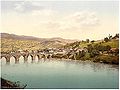
The largest impact the river has had in culture probably is the novel "Na Drini ćuprija
The Bridge on the Drina
The Bridge on the Drina , sometimes restyled as The Bridge Over the Drina, is a novel by Yugoslav writer Ivo Andrić. Andrić wrote the novel while living quietly in Belgrade during World War II, publishing it in 1945...
" (The Bridge on the Drina
The Bridge on the Drina
The Bridge on the Drina , sometimes restyled as The Bridge Over the Drina, is a novel by Yugoslav writer Ivo Andrić. Andrić wrote the novel while living quietly in Belgrade during World War II, publishing it in 1945...
) by the Nobel Prize
Nobel Prize
The Nobel Prizes are annual international awards bestowed by Scandinavian committees in recognition of cultural and scientific advances. The will of the Swedish chemist Alfred Nobel, the inventor of dynamite, established the prizes in 1895...
laureate, Ivo Andrić
Ivo Andric
Ivan "Ivo" Andrić was a Yugoslav novelist, short story writer, and the 1961 winner of the Nobel Prize in Literature. His writings dealt mainly with life in his native Bosnia under the Ottoman Empire...
; the book is about the building of a bridge
Mehmed Paša Sokolovic Bridge
The Mehmed Paša Sokolović Bridge is a historic bridge in Višegrad, over the Drina River in eastern Republika Srpska entity of Bosnia and Herzegovina. It was completed in 1577 AD by the Ottoman court architect Mimar Sinan on the order of the Grand Vizier Mehmed Paša Sokolović...
near Višegrad by the Ottomans
Ottoman Empire
The Ottoman EmpireIt was usually referred to as the "Ottoman Empire", the "Turkish Empire", the "Ottoman Caliphate" or more commonly "Turkey" by its contemporaries...
in the 16th century
See also
- Tara (Drina)
- Piva (river)
- NeretvaNeretvaNeretva is the largest river of the eastern part of the Adriatic basin. It has been harnessed and controlled to a large extent by four HE power-plants with large dams and their storage lakes, but it is still recognized for its natural beauty, diversity of its landscape and visual...
- Mehmed Paša Sokolović BridgeMehmed Paša Sokolovic BridgeThe Mehmed Paša Sokolović Bridge is a historic bridge in Višegrad, over the Drina River in eastern Republika Srpska entity of Bosnia and Herzegovina. It was completed in 1577 AD by the Ottoman court architect Mimar Sinan on the order of the Grand Vizier Mehmed Paša Sokolović...
- Sutjeska National ParkSutjeska National ParkThe Sutjeska National Park is a national park located in Bosnia and Herzegovina in the Republika Srpska entity. Established in 1962, it is Bosnia and Herzegovina 's oldest national park. It includes the highest peak of Maglić at over , on the border with Montenegro. The Montenegrin part of Maglić...
- List of national parks of Bosnia and Herzegovina
- Cultural and Historical information
External links
- Sutjeska National Park
- Commission to Preserve National Monuments of Bosnia and Herzegovina
- Hydroelectric Power Plant BUK BIJELA
- Hydroelectric Power Plant FOČA
- Hydroelectric Power Plaint ZVORNIK
- Mala Prosvetina Enciklopedija, Third edition (1985); Prosveta; ISBN 86-07-00001-2
- Jovan Đ. Marković (1990): Enciklopedijski geografski leksikon Jugoslavije; Svjetlost-Sarajevo; ISBN 86-01-02651-6
- Slobodan Ristanović: "Prvenac na Drini"
- Battle of the Drina