
Pinkie Road
Encyclopedia
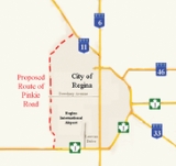
Pinkie Road is a proposed 4 lane twinned
highway connector road linking two National Highway System routes as a part of the Asia-Pacific Gateway and Corridor Initiative (APGCI). Highway 1
(the Trans-Canada Highway
) and Highway 11
will be linked by this new route, west of Regina
, Saskatchewan
. The City of Regina, Sherwood No. 159
rural municipality (RM)
Ministry of Highways and Infrastructure (MHI)
and Transport Canada
have come together to begin construction of Pinkie Road which will provide access to an inland port
comprising a global communications hub, the Canadian Pacific Railway
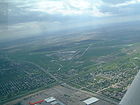
intermodal facility, Regina International Airport
, as well as a warehouse and industrial area. Located northwest the city, the partners are evaluating the environmental concerns, national building requirements as well as feasibility for interchanges, lanes and speeds dependent on proposed Annual Average Daily Traffic amounts. The Regina Regional Economic Development Authority's president and CEO, Larry Hiles, said that "Regina is ideally situated with regard to both geography and infrastructure for this type of development."
 Pinkie Road is a proposed Saskatchewan Highway 1
-to-Highway 11
connector road west of Regina, Saskatchewan
. The highway will run from Highway 1 north to the junction with Highway 730
(Dewdney Avenue West) and finally connect with Highway 11. A new interchange will be constructed at Hwy 1 and Lewvan Drive and the roadway infrastructure to access the new intermodal facility. Pinkie Road will run west of the Regina International Airport
, with three proposed alignments being studied.
rural municipality (RM)
Ministry of Highways and Infrastructure (MHI)
and Transport Canada
to provide an Intermodal freight transport
center and the road infrastructure between two National Highway System routes. C
$27 million will be contributed by the Government of Canada
as part of the Asia-Pacific Gateway and Corridor Initiative (APGCI) towards this $93 million project. The provincial government will commit about $27 million to the project. Highways and Infrastructure Minister Wayne Elhard is discussing expanding the Government's role in the next phase of the development project. The average vehicles per day (vpd) on both Hwy 1 and Hwy 11 were examined in 5 year, and 25 year projections. The traffic on Hwy 1 is expected to have an average of 10,140 / 11,210 vpd on the west and east side of the proposed interchange in five years. This amount in 25 years is expected to increase to 21,040 vpd on the west and 31, 340 vpd on the east side of the proposed interchange respectively. Hwy 11 is projected to increase from 13,060 to 23870 vpd in 25 years. The new connector road across Dewdney Avenue will carry 5,500 vpd projected in 5 years increasing to 33,000 vpd in 25 years. Currently the Average Annual Daily Traffic (AADT) on Hwy 1 is 9,280 vpd west of Pinkie Road, and 11,680 on the east side of Pinkie Road. On Hwy 11 east of the interchange the AADT is 8,840. On Pinkie Road south of the interchange the traffic volume is 7,740 vpd. John Law, deputy minister of Highways and Infrastructure estimated that it will cost about $45 million to upgrade service roads to Pinkie Road and the intermodal facility to support approximately 1,400 commercial trucks per week in the area. The current proposal is looking at a 4 lane twinned
highway with service roads. It will become part of the long term bypass route around Regina, and will accommodate future growth of the city to a population of 300,000. Pinkie Road will be approximately 26 kilometres (16.2 mi) in length. The annexation of land by the city from the RM of Sherwood is being negotiated and the city will pay about $1,500,000 and supply water to the RM for the land segment.
The city initially considered four industrial land options for development Argyle Park - IPSCO lands, Regina Airport, Ross Industrial Park and the Pinkie Road and Trans-Canada Highway areas. In November 2007, Regina City Council examined a report which studied projected industrial growth for the city of Regina until 2027. The study proposed a new industrial area west of the Regina airport. The major roads would be constructed by the Ministry of Highways and Infrastructure and they would be supported by a $7 million payment by the City of Regina. The city also examined at this concept plan the cost of $54 million for infrastructure servicing of facilities. Regina's general manager of corporate services is looking at servicing fees and development levies to help repay the loan. A 20 year time frame will extend land use to also include a light industrial park. A number of open houses were held with the public to determine planning, road alignments, access points and general location of the new connector road. Following the advisement of two consultation firms the City of Regina has determined to proceed with the land development and water, drainage, and wastewater management procedures outlined for the Regina Inland Port. There will be two phases of land development the land development west of Pinkie Road will constitute phase 1 and east of Pinkie Road will be Phase 2.
 The Canadian Pacific Railway (CPR)
intermodal facility (IMF) currently located in Regina's downtown will be re-located west of the city which will enable the CPR to expand its facilities at a new location enabling a more efficient staging of trains. The Regina Regional Economic Development Authority RREDA has worked on establishing Regina as a transportation hub, and this inland port brings together air, road and rail travel services for the export and import of goods. The CPR IMF will be joined by Loblaws Company Limited $200-million western Canadian distribution facility. The multimodal hub will encourage North American trade and world distribution, transportation, imports and exports.
 The proposal is studying the impact the new roadway will have on protected species of fauna in Saskatchewan
such as the burrowing owl (Athene cunicularia)
, loggerhead shrike (Lanius ludovicianus)
, Sprague's pipit {Anthus spragueii}
, peregrine pflcon (Falco peregrinus)
, yellow rail (Coturnicops noveboracensis)
, monarch butterfly (Danaus plexippus) and northern leopard frog (Rana pipiens)
. Flora of Saskatchewan
which may be impacted would be the Prairie Ragwort (Senecio plattensis)
and Geyer's onion (Allium geyeri)
. The Presbyterian Indian Residential School Cemetery is also located in this vicinity north of Dewdney Avenue and east of Pinkie Road. The project is being planned to meet any requirements set forth under the Building Canada Plan as well as evaluation of project procedures for environmental concerns as set out by the Canadian Environmental Assessment Act.
Dual carriageway
A dual carriageway is a class of highway with two carriageways for traffic travelling in opposite directions separated by a central reservation...
highway connector road linking two National Highway System routes as a part of the Asia-Pacific Gateway and Corridor Initiative (APGCI). Highway 1
Saskatchewan Highway 1
Highway 1 is the Saskatchewan section of the Trans-Canada Highway mainland route. The total distance of the Trans-Canada Highway in Saskatchewan is . The highway traverses Saskatchewan from the western border with Alberta, from Highway 1, to Manitoba where it continues as Highway 1, PTH 1. The...
(the Trans-Canada Highway
Trans-Canada Highway
The Trans-Canada Highway is a federal-provincial highway system that joins the ten provinces of Canada. It is, along with the Trans-Siberian Highway and Australia's Highway 1, one of the world's longest national highways, with the main route spanning 8,030 km...
) and Highway 11
Saskatchewan Highway 11
Highway 11 is a major north-south highway in Saskatchewan, Canada that connects the province's three largest cities: Regina, Saskatoon and Prince Albert. It is a structural pavement major arterial highway which is approximately long. It is also known as the Louis Riel Trail after the 19th century...
will be linked by this new route, west of Regina
Regina, Saskatchewan
Regina is the capital city of the Canadian province of Saskatchewan. The city is the second-largest in the province and a cultural and commercial centre for southern Saskatchewan. It is governed by Regina City Council. Regina is the cathedral city of the Roman Catholic and Romanian Orthodox...
, Saskatchewan
Saskatchewan
Saskatchewan is a prairie province in Canada, which has an area of . Saskatchewan is bordered on the west by Alberta, on the north by the Northwest Territories, on the east by Manitoba, and on the south by the U.S. states of Montana and North Dakota....
. The City of Regina, Sherwood No. 159
Sherwood No. 159, Saskatchewan
Sherwood Rural Municipality Number 159 is a rural municipality in southeastern Saskatchewan, Canada. It encircles and is an exurb of the city of Regina, the provincial capital. Also within the borders of Sherwood is the separately governed village of Grand Coulee...
rural municipality (RM)
Rural municipality
A rural municipality, often abbreviated RM, is a form of municipality in the Canadian provinces of Manitoba and Saskatchewan, perhaps best comparable to counties or townships in the western United States...
Ministry of Highways and Infrastructure (MHI)
Ministry of Highways and Infrastructure (Saskatchewan)
The Ministry of Highways and Infrastructure or Highways and Infrastructure — Government of Saskatchewan Ministry of Highways is divided into the Operations, Policy and Programs, and Corporate Services Divisions and the Communications Branch. The ministry is the employer of over 1,476...
and Transport Canada
Transport Canada
Transport Canada is the department within the government of Canada which is responsible for developing regulations, policies and services of transportation in Canada. It is part of the Transportation, Infrastructure and Communities portfolio...
have come together to begin construction of Pinkie Road which will provide access to an inland port
Inland port
The term inland port is used in two different but related ways to mean either a port on an inland waterway or an inland site carrying out some functions of a seaport.- As a port on an inland waterway :...
comprising a global communications hub, the Canadian Pacific Railway
Canadian Pacific Railway
The Canadian Pacific Railway , formerly also known as CP Rail between 1968 and 1996, is a historic Canadian Class I railway founded in 1881 and now operated by Canadian Pacific Railway Limited, which began operations as legal owner in a corporate restructuring in 2001...
intermodal facility, Regina International Airport
Regina International Airport
Regina International Airport is an international airport located in Regina, Saskatchewan, Canada, located south-west and west south-west of the city centre. It is run by the Regina Airport Authority. It is, as of 2010, the second busiest airport in Saskatchewan Regina International Airport is...
, as well as a warehouse and industrial area. Located northwest the city, the partners are evaluating the environmental concerns, national building requirements as well as feasibility for interchanges, lanes and speeds dependent on proposed Annual Average Daily Traffic amounts. The Regina Regional Economic Development Authority's president and CEO, Larry Hiles, said that "Regina is ideally situated with regard to both geography and infrastructure for this type of development."
Travel route
Saskatchewan Highway 1
Highway 1 is the Saskatchewan section of the Trans-Canada Highway mainland route. The total distance of the Trans-Canada Highway in Saskatchewan is . The highway traverses Saskatchewan from the western border with Alberta, from Highway 1, to Manitoba where it continues as Highway 1, PTH 1. The...
-to-Highway 11
Saskatchewan Highway 11
Highway 11 is a major north-south highway in Saskatchewan, Canada that connects the province's three largest cities: Regina, Saskatoon and Prince Albert. It is a structural pavement major arterial highway which is approximately long. It is also known as the Louis Riel Trail after the 19th century...
connector road west of Regina, Saskatchewan
Regina, Saskatchewan
Regina is the capital city of the Canadian province of Saskatchewan. The city is the second-largest in the province and a cultural and commercial centre for southern Saskatchewan. It is governed by Regina City Council. Regina is the cathedral city of the Roman Catholic and Romanian Orthodox...
. The highway will run from Highway 1 north to the junction with Highway 730
Saskatchewan Highway 730
Highway 730 is a highway in the Canadian province of Saskatchewan. It runs from Highway 641 until Regina, where it becomes Dewdney Avenue. Highway 730 is about 18 km long....
(Dewdney Avenue West) and finally connect with Highway 11. A new interchange will be constructed at Hwy 1 and Lewvan Drive and the roadway infrastructure to access the new intermodal facility. Pinkie Road will run west of the Regina International Airport
Regina International Airport
Regina International Airport is an international airport located in Regina, Saskatchewan, Canada, located south-west and west south-west of the city centre. It is run by the Regina Airport Authority. It is, as of 2010, the second busiest airport in Saskatchewan Regina International Airport is...
, with three proposed alignments being studied.
History
Pinkie Road will be a primary access highway with access points for the Global Transportation Hub (GTH). The project is undertaken by the City of Regina, Sherwood No. 159Sherwood No. 159, Saskatchewan
Sherwood Rural Municipality Number 159 is a rural municipality in southeastern Saskatchewan, Canada. It encircles and is an exurb of the city of Regina, the provincial capital. Also within the borders of Sherwood is the separately governed village of Grand Coulee...
rural municipality (RM)
Rural municipality
A rural municipality, often abbreviated RM, is a form of municipality in the Canadian provinces of Manitoba and Saskatchewan, perhaps best comparable to counties or townships in the western United States...
Ministry of Highways and Infrastructure (MHI)
Ministry of Highways and Infrastructure (Saskatchewan)
The Ministry of Highways and Infrastructure or Highways and Infrastructure — Government of Saskatchewan Ministry of Highways is divided into the Operations, Policy and Programs, and Corporate Services Divisions and the Communications Branch. The ministry is the employer of over 1,476...
and Transport Canada
Transport Canada
Transport Canada is the department within the government of Canada which is responsible for developing regulations, policies and services of transportation in Canada. It is part of the Transportation, Infrastructure and Communities portfolio...
to provide an Intermodal freight transport
Intermodal freight transport
Intermodal freight transport involves the transportation of freight in an intermodal container or vehicle, using multiple modes of transportation , without any handling of the freight itself when changing modes. The method reduces cargo handling, and so improves security, reduces damages and...
center and the road infrastructure between two National Highway System routes. C
Canadian dollar
The Canadian dollar is the currency of Canada. As of 2007, the Canadian dollar is the 7th most traded currency in the world. It is abbreviated with the dollar sign $, or C$ to distinguish it from other dollar-denominated currencies...
$27 million will be contributed by the Government of Canada
Government of Canada
The Government of Canada, formally Her Majesty's Government, is the system whereby the federation of Canada is administered by a common authority; in Canadian English, the term can mean either the collective set of institutions or specifically the Queen-in-Council...
as part of the Asia-Pacific Gateway and Corridor Initiative (APGCI) towards this $93 million project. The provincial government will commit about $27 million to the project. Highways and Infrastructure Minister Wayne Elhard is discussing expanding the Government's role in the next phase of the development project. The average vehicles per day (vpd) on both Hwy 1 and Hwy 11 were examined in 5 year, and 25 year projections. The traffic on Hwy 1 is expected to have an average of 10,140 / 11,210 vpd on the west and east side of the proposed interchange in five years. This amount in 25 years is expected to increase to 21,040 vpd on the west and 31, 340 vpd on the east side of the proposed interchange respectively. Hwy 11 is projected to increase from 13,060 to 23870 vpd in 25 years.
Dual carriageway
A dual carriageway is a class of highway with two carriageways for traffic travelling in opposite directions separated by a central reservation...
highway with service roads. It will become part of the long term bypass route around Regina, and will accommodate future growth of the city to a population of 300,000. Pinkie Road will be approximately 26 kilometres (16.2 mi) in length. The annexation of land by the city from the RM of Sherwood is being negotiated and the city will pay about $1,500,000 and supply water to the RM for the land segment.
The city initially considered four industrial land options for development Argyle Park - IPSCO lands, Regina Airport, Ross Industrial Park and the Pinkie Road and Trans-Canada Highway areas. In November 2007, Regina City Council examined a report which studied projected industrial growth for the city of Regina until 2027. The study proposed a new industrial area west of the Regina airport. The major roads would be constructed by the Ministry of Highways and Infrastructure and they would be supported by a $7 million payment by the City of Regina. The city also examined at this concept plan the cost of $54 million for infrastructure servicing of facilities. Regina's general manager of corporate services is looking at servicing fees and development levies to help repay the loan. A 20 year time frame will extend land use to also include a light industrial park. A number of open houses were held with the public to determine planning, road alignments, access points and general location of the new connector road. Following the advisement of two consultation firms the City of Regina has determined to proceed with the land development and water, drainage, and wastewater management procedures outlined for the Regina Inland Port. There will be two phases of land development the land development west of Pinkie Road will constitute phase 1 and east of Pinkie Road will be Phase 2.
Intermodal facility
Canadian Pacific Railway
The Canadian Pacific Railway , formerly also known as CP Rail between 1968 and 1996, is a historic Canadian Class I railway founded in 1881 and now operated by Canadian Pacific Railway Limited, which began operations as legal owner in a corporate restructuring in 2001...
intermodal facility (IMF) currently located in Regina's downtown will be re-located west of the city which will enable the CPR to expand its facilities at a new location enabling a more efficient staging of trains. The Regina Regional Economic Development Authority RREDA has worked on establishing Regina as a transportation hub, and this inland port brings together air, road and rail travel services for the export and import of goods. The CPR IMF will be joined by Loblaws Company Limited $200-million western Canadian distribution facility. The multimodal hub will encourage North American trade and world distribution, transportation, imports and exports.
Environmental and heritage impact
Fauna of Saskatchewan
The Fauna of Saskatchewan include several diverse land and aquatic animal species. From the multiplicity of invertebrates and vertebrates, two have been chosen as symbols of Saskatchewan. Cenozoic vertebrate fossils reveal the geological evolution of the interior plains and its prehistoric...
such as the burrowing owl (Athene cunicularia)
Burrowing Owl
The Burrowing Owl is a tiny but long-legged owl found throughout open landscapes of North and South America. Burrowing Owls can be found in grasslands, rangelands, agricultural areas, deserts, or any other open dry area with low vegetation. They nest and roost in burrows, such as those excavated...
, loggerhead shrike (Lanius ludovicianus)
Loggerhead Shrike
The Loggerhead Shrike is a passerine bird. It is the only member of the shrike family endemic to North America; the related Northern Shrike occurs north of its range but also in the Palearctic....
, Sprague's pipit {Anthus spragueii}
Sprague's Pipit
Sprague's Pipit is a small passerine bird that breeds in the short and mixed-grass prairies of North America and overwinters in the southwestern United States and northern Mexico. Easiest to identify by the distinctive descending call that is delivered in the breeding season from a considerable...
, peregrine pflcon (Falco peregrinus)
Peregrine Falcon
The Peregrine Falcon , also known as the Peregrine, and historically as the Duck Hawk in North America, is a widespread bird of prey in the family Falconidae. A large, crow-sized falcon, it has a blue-gray back, barred white underparts, and a black head and "moustache"...
, yellow rail (Coturnicops noveboracensis)
Yellow Rail
The Yellow Rail, Coturnicops noveboracensis, is a small waterbird, of the family Rallidae.Adults have brown upperparts streaked with black, a yellowish-brown breast, a light belly and barred flanks. The short thick dark bill turns yellow in males during the breeding season. The feathers on the back...
, monarch butterfly (Danaus plexippus) and northern leopard frog (Rana pipiens)
Northern Leopard Frog
The Northern Leopard Frog is a species of leopard frog from the true frog family, native to parts of Canada and United States. It is the state amphibian of Minnesota and Vermont.-Physical description:...
. Flora of Saskatchewan
Flora of Saskatchewan
The native flora of the Saskatchewan includes vascular plants, plus additional species of other plants and plant-like organisms such as algae, lichens and other fungi, and mosses...
which may be impacted would be the Prairie Ragwort (Senecio plattensis)
Senecio
Senecio is a genus of the daisy family that includes ragworts and groundsels. The flower heads are normally rayed, completely yellow, and the heads are borne in branched clusters...
and Geyer's onion (Allium geyeri)
Allium
Allium is a monocot genus of flowering plants, informally referred to as the onion genus. The generic name Allium is the Latin word for garlic....
. The Presbyterian Indian Residential School Cemetery is also located in this vicinity north of Dewdney Avenue and east of Pinkie Road. The project is being planned to meet any requirements set forth under the Building Canada Plan as well as evaluation of project procedures for environmental concerns as set out by the Canadian Environmental Assessment Act.