
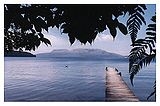
Lake Tarawera
Encyclopedia
Volcano
2. Bedrock3. Conduit 4. Base5. Sill6. Dike7. Layers of ash emitted by the volcano8. Flank| 9. Layers of lava emitted by the volcano10. Throat11. Parasitic cone12. Lava flow13. Vent14. Crater15...
Mount Tarawera
Mount Tarawera
Mount Tarawera is the volcano responsible for New Zealand's largest historic eruption. Located 24 kilometres southeast of Rotorua in the North Island, it consists of a series of rhyolitic lava domes that were fissured down the middle by an explosive basaltic eruption in 1886, which killed over...
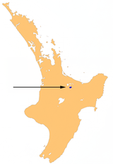
in the North Island
North Island
The North Island is one of the two main islands of New Zealand, separated from the much less populous South Island by Cook Strait. The island is in area, making it the world's 14th-largest island...
of New Zealand. Like the mountain, it lies within the Okataina caldera. It is located 18 kilometres to the east of Rotorua
Rotorua
Rotorua is a city on the southern shores of the lake of the same name, in the Bay of Plenty region of the North Island of New Zealand. The city is the seat of the Rotorua District, a territorial authority encompassing the city and several other nearby towns...
, and five kilometres to the west of the mountain. The lake's surface area is 39 km².
Geography
The lake was substantially affected by the eruption of Mount TaraweraMount Tarawera
Mount Tarawera is the volcano responsible for New Zealand's largest historic eruption. Located 24 kilometres southeast of Rotorua in the North Island, it consists of a series of rhyolitic lava domes that were fissured down the middle by an explosive basaltic eruption in 1886, which killed over...
on 10 June 1886. The eruption killed over 150 people, and buried the Māori village of Te Wairoa
Te Wairoa
Te Wairoa, also known as The Buried Village is located close to the shore of Lake Tarawera in New Zealand's North Island. It was a Māori and European settlement where visitors would stay on their way to visit the Pink and White Terraces. The village was destroyed by the eruption of the volcano...
on the southwest shore of the lake.
Tarawera means "Burnt Spear", named by a visiting hunter who left his bird spears in a hut and on returning the following season found both the spears and hut had been burned down completely.
The lake is filled primarily by sources from the nearby Blue (Lake Tikitapu
Lake Tikitapu
Lake Tikitapu or Blue Lake, is the smallest of four small lakes lying between Lake Rotorua and Lake Tarawera in the Bay of Plenty region of New Zealand's North Island. The others are Lake Rotokakahi , Lake Okareka, and Lake Okataina....
) and Green (Lake Rotokakahi
Lake Rotokakahi
Lake Rotokakahi or Green Lake, is one of four small lakes lying between Lake Rotorua and Lake Tarawera in the Bay of Plenty region of New Zealand's North Island. The others are Lake Tikitapu , Lake Okareka, and Lake Okataina...
) lakes. Lake Tarawera is home to eel
Eel
Eels are an order of fish, which consists of four suborders, 20 families, 111 genera and approximately 800 species. Most eels are predators...
s and rainbow trout
Rainbow trout
The rainbow trout is a species of salmonid native to tributaries of the Pacific Ocean in Asia and North America. The steelhead is a sea run rainbow trout usually returning to freshwater to spawn after 2 to 3 years at sea. In other words, rainbow trout and steelhead trout are the same species....
. During the summer it is popular for both fishing and water sports, and also camping as there a number of hot water beaches. Lake Tarawera's outflow is at its north end, into the Tarawera River
Tarawera River
The Tarawera River is in the Bay of Plenty Region in the North Island of New Zealand.It flows from Lake Tarawera, northeastwards across the northern flanks of the active volcano Mount Tarawera, and past the town of Kawerau before turning north, reaching the Bay of Plenty six kilometres to the west...
, which flows northeast into the Bay of Plenty
Bay of Plenty
The Bay of Plenty , often abbreviated to BOP, is a region in the North Island of New Zealand situated around the body of water of the same name...
.