

Lamont-Doherty Earth Observatory
Encyclopedia
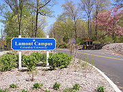
The Lamont–Doherty Earth Observatory (LDEO) is a research unit of Columbia University
located on a 157 acre (0.63535702 km²) campus in Palisades, N.Y., 18 miles (29 km) north of Manhattan
on the Hudson River
.

and Florence Haskell Corliss Lamont, which was donated to the university for that purpose. The Observatory’s founder and first director was Maurice "Doc" Ewing
, a seismologist who is credited with advancing efforts to study the solid earth, particularly in areas related to using sound waves to image rock and sediments beneath the ocean floor. He was also the first to collect sediment core sample
s from the bottom of the ocean, a common practice today that helps scientists study changes in the planet's climate and the ocean's thermohaline circulation
.
In 1969, the Observatory was renamed Lamont–Doherty in honor of a major gift from the Henry L. and Grace Doherty Charitable Foundation; in 1993, it was renamed the Lamont–Doherty Earth Observatory in recognition of its expertise in the broad range of earth sciences. Today, it is a major research component of the Earth Institute at Columbia University, a collection of academic and research units within the university that together address complex environmental issues facing the planet and its inhabitants, with particular focus on advancing scientific research to support sustainable development
and the needs of the world's poor.
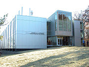
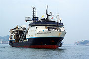
To support its research and the work of the broader scientific community, Lamont–Doherty operates the 235 feet (71.6 m) research vessel, the R/V Marcus Langseth, which is equipped to undertake a wide range of geological, seismological, oceanographic and biological studies. Lamont–Doherty also houses the world's largest collection of deep-sea and ocean-sediment cores as well as many specialized research laboratories.
s, geochemists, biologist
s and environmental scientists who pursue research in two connected efforts. First, because all biological organisms record the environment in which they exist, BPE scientists use biology to uncover clues about earth’s past environment. They also attempt to understand how modern environmental conditions affect present-day biology. To do this, BPE scientists turn to a number of primary sources, including deep-sea sediment cores (and the fossils of phytoplankton
and zooplankton
they contain), samples from coral reefs, and growth rings
of trees.
and isotopic
analyses, division scientists study samples of air, water, biological remains, rocks and meteorites in order to address a broad range of scientific issues, ranging from the particulate and chemical pollutants emitted by the collapse of the World Trade Center, to changes in earth's past climate, to the fundamental chemical processes involved in the differentiation and formation of the planet's mantle
and core.
and multi-channel seismic imaging
to map the surface and sub-surface, as well as satellite-based remote sensing
. An early success of MG&G researchers was the discovery of seafloor spreading
, which led to the general acceptance of plate tectonics as the broad foundation for understanding earthquake generation. Other MG&G scientists study the interface between ice sheets and bedrock, sediment transport in the Hudson River, and meteorite impacts in the deep ocean.
, solid earth dynamics, rock mechanics, structural geology and tectonics, and sedimentary geology. They also contribute to understanding of earthquakes; the structure of earth’s crust
, mantle, and core; and the large-scale motions and deformation of the tectonic plates. In addition, the division operates several facilities for the scientific community. In partnership with the U.S. Geological Survey, SGT operates a network of seismographs throughout the northeastern U.S., supports National Science Foundation
(NSF) efforts to conduct ocean-bottom seismology research, and provides accurate earthquake source mechanisms to government and academic researchers around the world.
and the formation of a group within the Observatory to organize and support research missions. Today, the Office of Marine Operations oversees geophysical and oceanographic studies onboard the Observatory's latest research vessel, the R/V Marcus Langseth, and conducts its own research on the character and operation of various geophysical imaging systems employed by the scientific community.
, geology
, paleoclimatology
, paleontology
, physical oceanography
, solid earth geophysics
, and solid earth geochemistry
. Specific programs at Lamont–Doherty are conducted with many education-affiliates at Columbia and elsewhere in the New York metro area.
and its successor, the Integrated Ocean Drilling Program
, BRG helps direct and support operations on the research drill ship JOIDES Resolution
.
Columbia University
Columbia University in the City of New York is a private, Ivy League university in Manhattan, New York City. Columbia is the oldest institution of higher learning in the state of New York, the fifth oldest in the United States, and one of the country's nine Colonial Colleges founded before the...
located on a 157 acre (0.63535702 km²) campus in Palisades, N.Y., 18 miles (29 km) north of Manhattan
Manhattan
Manhattan is the oldest and the most densely populated of the five boroughs of New York City. Located primarily on the island of Manhattan at the mouth of the Hudson River, the boundaries of the borough are identical to those of New York County, an original county of the state of New York...
on the Hudson River
Hudson River
The Hudson is a river that flows from north to south through eastern New York. The highest official source is at Lake Tear of the Clouds, on the slopes of Mount Marcy in the Adirondack Mountains. The river itself officially begins in Henderson Lake in Newcomb, New York...
.
History
The Lamont–Doherty Earth Observatory (LDEO) was established in 1949 as the Lamont Geological Observatory on the weekend estate of Thomas W.Thomas W. Lamont
Thomas William Lamont, Jr. was an American banker.- Biography :Lamont was born in Claverack, New York. He graduated from Phillips Exeter Academy in 1888 and earned his degree from Harvard University in 1892. He became a generous benefactor of the school once he had amassed a fortune, notably...
and Florence Haskell Corliss Lamont, which was donated to the university for that purpose. The Observatory’s founder and first director was Maurice "Doc" Ewing
Maurice Ewing
William Maurice "Doc" Ewing was an American geophysicist and oceanographer.Ewing has been described as a pioneering geophysicist who worked on the research of seismic reflection and refraction in ocean basins, ocean bottom photography, submarine sound transmission , deep sea coring of the ocean...
, a seismologist who is credited with advancing efforts to study the solid earth, particularly in areas related to using sound waves to image rock and sediments beneath the ocean floor. He was also the first to collect sediment core sample
Core sample
A core sample is a cylindrical section of a naturally occurring substance. Most core samples are obtained by drilling with special drills into the substance, for example sediment or rock, with a hollow steel tube called a core drill. The hole made for the core sample is called the "core hole". A...
s from the bottom of the ocean, a common practice today that helps scientists study changes in the planet's climate and the ocean's thermohaline circulation
Thermohaline circulation
The term thermohaline circulation refers to a part of the large-scale ocean circulation that is driven by global density gradients created by surface heat and freshwater fluxes....
.
In 1969, the Observatory was renamed Lamont–Doherty in honor of a major gift from the Henry L. and Grace Doherty Charitable Foundation; in 1993, it was renamed the Lamont–Doherty Earth Observatory in recognition of its expertise in the broad range of earth sciences. Today, it is a major research component of the Earth Institute at Columbia University, a collection of academic and research units within the university that together address complex environmental issues facing the planet and its inhabitants, with particular focus on advancing scientific research to support sustainable development
Sustainable development
Sustainable development is a pattern of resource use, that aims to meet human needs while preserving the environment so that these needs can be met not only in the present, but also for generations to come...
and the needs of the world's poor.
To support its research and the work of the broader scientific community, Lamont–Doherty operates the 235 feet (71.6 m) research vessel, the R/V Marcus Langseth, which is equipped to undertake a wide range of geological, seismological, oceanographic and biological studies. Lamont–Doherty also houses the world's largest collection of deep-sea and ocean-sediment cores as well as many specialized research laboratories.
Mission statement
The Lamont–Doherty Earth Observatory, a member of the Earth Institute at Columbia University, is one of the world’s leading research centers seeking fundamental knowledge about the origin, evolution and future of the natural world. More than 300 research scientists and students study the planet from its deepest interior to the outer reaches of its atmosphere, on every continent and in every ocean. From global climate change to earthquakes, volcanoes, nonrenewable resources, environmental hazards and beyond, Observatory scientists provide a rational basis for the difficult choices facing humankind in the planet’s stewardship.Major achievements
Of the contributions that Lamont–Doherty scientists have made to understanding of the earth system over the years, several stand out:- Provided the first definitive evidence to support the theory of plate tectonicsPlate tectonicsPlate tectonics is a scientific theory that describes the large scale motions of Earth's lithosphere...
and continental driftContinental driftContinental drift is the movement of the Earth's continents relative to each other. The hypothesis that continents 'drift' was first put forward by Abraham Ortelius in 1596 and was fully developed by Alfred Wegener in 1912... - First explained the role of large-scale ocean circulation systems in abrupt climate changeAbrupt climate changeAn abrupt climate change occurs when the climate system is forced to transition to a new state at a rate that is determined by the climate system itself, and which is more rapid than the rate of change of the external forcing...
- Provided the first evidence that the Earth's core is spinning faster than the rest of the planet
- First to systematically study and first to create a global topographic mapMarie TharpMarie Tharp was a geologist and oceanographic cartographer who, along with her colleague Bruce Heezen, mapped the ocean floor including the Mid-Oceanic Ridges, a line of undersea mountains.-Biography:...
of the oceans - Demonstrated that changes in the Earth's past climate were linked to changes in the planet's rotation and orbit as well as the sun's outputSolar cycleThe solar cycle, or the solar magnetic activity cycle, is a periodic change in the amount of irradiation from the Sun that is experienced on Earth. It has a period of about 11 years, and is one component of solar variation, the other being aperiodic fluctuations. Solar variation causes changes in...
- Made the first successful prediction of extreme weather associated with an El Niño event
- First to detect nuclear explosions using seismometers and continue monitoring work as part of the Comprehensive Nuclear Test Ban Treaty
- Developed the first lunar seismometers and conducted some of the earliest analyses of the moon's structure and tectonic activity
Biology and paleo environment
The Division of Biology and Paleo Environment (BPE) includes oceanographers, geologistGeologist
A geologist is a scientist who studies the solid and liquid matter that constitutes the Earth as well as the processes and history that has shaped it. Geologists usually engage in studying geology. Geologists, studying more of an applied science than a theoretical one, must approach Geology using...
s, geochemists, biologist
Biologist
A biologist is a scientist devoted to and producing results in biology through the study of life. Typically biologists study organisms and their relationship to their environment. Biologists involved in basic research attempt to discover underlying mechanisms that govern how organisms work...
s and environmental scientists who pursue research in two connected efforts. First, because all biological organisms record the environment in which they exist, BPE scientists use biology to uncover clues about earth’s past environment. They also attempt to understand how modern environmental conditions affect present-day biology. To do this, BPE scientists turn to a number of primary sources, including deep-sea sediment cores (and the fossils of phytoplankton
Phytoplankton
Phytoplankton are the autotrophic component of the plankton community. The name comes from the Greek words φυτόν , meaning "plant", and πλαγκτός , meaning "wanderer" or "drifter". Most phytoplankton are too small to be individually seen with the unaided eye...
and zooplankton
Zooplankton
Zooplankton are heterotrophic plankton. Plankton are organisms drifting in oceans, seas, and bodies of fresh water. The word "zooplankton" is derived from the Greek zoon , meaning "animal", and , meaning "wanderer" or "drifter"...
they contain), samples from coral reefs, and growth rings
Dendrochronology
Dendrochronology or tree-ring dating is the scientific method of dating based on the analysis of patterns of tree-rings. Dendrochronology can date the time at which tree rings were formed, in many types of wood, to the exact calendar year...
of trees.
Geochemistry
Researchers in the Division of Geochemistry study the processes, past and present, that have governed earth’s many environments. Using chemicalAnalytical chemistry
Analytical chemistry is the study of the separation, identification, and quantification of the chemical components of natural and artificial materials. Qualitative analysis gives an indication of the identity of the chemical species in the sample and quantitative analysis determines the amount of...
and isotopic
Isotope analysis
Isotope analysis is the identification of isotopic signature, the distribution of certain stable isotopes and chemical elements within chemical compounds. This can be applied to a food web to make it possible to draw direct inferences regarding diet, trophic level, and subsistence...
analyses, division scientists study samples of air, water, biological remains, rocks and meteorites in order to address a broad range of scientific issues, ranging from the particulate and chemical pollutants emitted by the collapse of the World Trade Center, to changes in earth's past climate, to the fundamental chemical processes involved in the differentiation and formation of the planet's mantle
Mantle (geology)
The mantle is a part of a terrestrial planet or other rocky body large enough to have differentiation by density. The interior of the Earth, similar to the other terrestrial planets, is chemically divided into layers. The mantle is a highly viscous layer between the crust and the outer core....
and core.
Marine geology and geophysics
As its name implies, scientists in the Division of Marine Geology and Geophysics (MG&G) are primarily concerned with studying the structure and evolution of the Earth's seafloor. To do so, they employ tools that include side-scan sonarSide-scan sonar
Side-scan sonar is a category of sonar system that is used to efficiently create an image of large areas of the sea floor...
and multi-channel seismic imaging
Reflection seismology
Reflection seismology is a method of exploration geophysics that uses the principles of seismology to estimate the properties of the Earth's subsurface from reflected seismic waves. The method requires a controlled seismic source of energy, such as dynamite/Tovex, a specialized air gun or a...
to map the surface and sub-surface, as well as satellite-based remote sensing
Remote sensing
Remote sensing is the acquisition of information about an object or phenomenon, without making physical contact with the object. In modern usage, the term generally refers to the use of aerial sensor technologies to detect and classify objects on Earth by means of propagated signals Remote sensing...
. An early success of MG&G researchers was the discovery of seafloor spreading
Seafloor spreading
Seafloor spreading is a process that occurs at mid-ocean ridges, where new oceanic crust is formed through volcanic activity and then gradually moves away from the ridge. Seafloor spreading helps explain continental drift in the theory of plate tectonics....
, which led to the general acceptance of plate tectonics as the broad foundation for understanding earthquake generation. Other MG&G scientists study the interface between ice sheets and bedrock, sediment transport in the Hudson River, and meteorite impacts in the deep ocean.
Ocean and climate physics
The Division of Ocean and Climate Physics (OCP) focuses on the links between earth’s climate system and its oceans, including interactions involving the atmosphere, ocean circulation, planetary volcanism, the cryosphere, the biosphere and external forces such as variability of solar radiation and even the occasional asteroid impact. Scientists are also increasingly interested in understanding the nature of past and present changes to earth’s climate—whether abrupt or gradual, regional or global—and the potential for human activities to influence the natural system.Division of seismology, geology and geophysics
The researchers in the Seismology, Geology and Tectonophysics Division (SGT) study theoretical and observational seismologySeismology
Seismology is the scientific study of earthquakes and the propagation of elastic waves through the Earth or through other planet-like bodies. The field also includes studies of earthquake effects, such as tsunamis as well as diverse seismic sources such as volcanic, tectonic, oceanic,...
, solid earth dynamics, rock mechanics, structural geology and tectonics, and sedimentary geology. They also contribute to understanding of earthquakes; the structure of earth’s crust
Crust (geology)
In geology, the crust is the outermost solid shell of a rocky planet or natural satellite, which is chemically distinct from the underlying mantle...
, mantle, and core; and the large-scale motions and deformation of the tectonic plates. In addition, the division operates several facilities for the scientific community. In partnership with the U.S. Geological Survey, SGT operates a network of seismographs throughout the northeastern U.S., supports National Science Foundation
National Science Foundation
The National Science Foundation is a United States government agency that supports fundamental research and education in all the non-medical fields of science and engineering. Its medical counterpart is the National Institutes of Health...
(NSF) efforts to conduct ocean-bottom seismology research, and provides accurate earthquake source mechanisms to government and academic researchers around the world.
Office of Marine Operations and R/V Marcus G. Langseth
The history of Lamont–Doherty's sea-going research began in 1953 with the acquisition of the R/V VemaRV Vema
The research vessel Vema was a three-masted schooner of the Lamont Geological Observatory , a research unit of Columbia University. The . vessel, with her almost indestructible Swedish steel hull, became renowned as one of the world’s most productive oceanographic research vessels...
and the formation of a group within the Observatory to organize and support research missions. Today, the Office of Marine Operations oversees geophysical and oceanographic studies onboard the Observatory's latest research vessel, the R/V Marcus Langseth, and conducts its own research on the character and operation of various geophysical imaging systems employed by the scientific community.
Department of Earth and Environmental Science
The Department of Earth and Environmental Science (DEES) is the educational arm of Columbia University located on the Lamont–Doherty campus to train graduate and undergraduate students enrolled at the university and at Barnard College. The Lamont–Doherty office of DEES primarily supports the department's graduate program, though many undergraduate students take classes and conduct research at the Observatory. At any given time, between 80 and 90 Ph.D. students are working towards degrees in specialties that include aqueous geochemistry, atmospheric science, climate science, ecophysiologyEcophysiology
Ecophysiology or environmental physiology is a biological discipline which studies the adaptation of organism's physiology to environmental conditions...
, geology
Geology
Geology is the science comprising the study of solid Earth, the rocks of which it is composed, and the processes by which it evolves. Geology gives insight into the history of the Earth, as it provides the primary evidence for plate tectonics, the evolutionary history of life, and past climates...
, paleoclimatology
Paleoclimatology
Paleoclimatology is the study of changes in climate taken on the scale of the entire history of Earth. It uses a variety of proxy methods from the Earth and life sciences to obtain data previously preserved within rocks, sediments, ice sheets, tree rings, corals, shells and microfossils; it then...
, paleontology
Paleontology
Paleontology "old, ancient", ὄν, ὀντ- "being, creature", and λόγος "speech, thought") is the study of prehistoric life. It includes the study of fossils to determine organisms' evolution and interactions with each other and their environments...
, physical oceanography
Physical oceanography
Physical oceanography is the study of physical conditions and physical processes within the ocean, especially the motions and physical properties of ocean waters.Physical oceanography is one of several sub-domains into which oceanography is divided...
, solid earth geophysics
Geophysics
Geophysics is the physics of the Earth and its environment in space; also the study of the Earth using quantitative physical methods. The term geophysics sometimes refers only to the geological applications: Earth's shape; its gravitational and magnetic fields; its internal structure and...
, and solid earth geochemistry
Geochemistry
The field of geochemistry involves study of the chemical composition of the Earth and other planets, chemical processes and reactions that govern the composition of rocks, water, and soils, and the cycles of matter and energy that transport the Earth's chemical components in time and space, and...
. Specific programs at Lamont–Doherty are conducted with many education-affiliates at Columbia and elsewhere in the New York metro area.
Major facilities and initiatives
Deep-sea sample repository
The Lamont–Doherty Deep-Sea Sample Repository is both an archive of sediment and rocks from on and beneath the ocean floor—more than 19,000, from every ocean and sea—and an archive of digital data pertaining to the material. Both are used to research earth's climate and environment, as well as for many other studies, and for educational purposes.Tree ring lab
The Tree-Ring Lab (TRL) is dedicated to the application of tree-ring research around the world to improve understanding of earth's past climate and environmental history. Current research concentrates on the use of tree-ring data networks to study regional climate, global climate teleconnections and anthropogenic impacts on tree growth.Ocean bottom seismology lab
The Ocean Bottom Seismology (OBS) Lab develops and operates instruments used to measure deformation of the ocean floor in cooperation with the NSF's National Ocean Bottom Seismograph Instrumentation Pool (OBSIP). These instruments permit the study of such phenomena as seafloor spreading and the formation of new crust, convective and hydrothermal processes beneath the seafloor, and the fate of subducting slabs.Borehole research group
The Borehole Research Group (BRG) makes and analyzes geophysical measurements down drill holes in continental or seafloor crust to study such phenomena as sea level variation, fluid flow through fractured rock, and the properties of natural gas hydrates. As part of the Ocean Drilling ProgramOcean Drilling Program
The Ocean Drilling Program was an international cooperative effort to explore and study the composition and structure of the Earth's ocean basins. ODP, which began in 1985, was the direct successor to the highly successful Deep Sea Drilling Project initiated in 1968 by the United States...
and its successor, the Integrated Ocean Drilling Program
Integrated Ocean Drilling Program
The Integrated Ocean Drilling Program is an international marine research program. The program uses heavy drilling equipment mounted aboard ships to monitor and sample sub-seafloor environments...
, BRG helps direct and support operations on the research drill ship JOIDES Resolution
JOIDES Resolution
thumb|right|295px|Drillship JOIDES Resolution in 1988JOIDES Resolution is a scientific drilling ship once used by the Ocean Drilling Program, then by its successor, the Integrated Ocean Drilling Program. It is the successor of the Glomar Challenger.The ship was launched as Sedco/BP 471, an oil...
.