
Pennsylvania Route 666
Encyclopedia
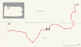
Pennsylvania Route 666 is an east–west state route located in northwest Pennsylvania
. The western terminus of the route is at U.S. Route 62 in the Hickory Township
municipality of East Hickory, and its eastern terminus is at U.S. Route 6 in the hamlet
of Sheffield in the township of the same name
. It cuts through most of Allegheny National Forest
, and is therefore sparsely populated, with the largest settlement along the road being Endeavor, Pennsylvania
. Its official name is the David Zeisberger
Memorial Highway.
The route was assigned in the 1928 numbering of State Routes in Pennsylvania. The highway originally ended in Nebraska, Pennsylvania until being extended southward along other streets. The route was realigned in 1946 onto its present routing. The highway has remained the same since.
along the banks of the Allegheny River
in East Hickory. The route progresses eastward, intersecting with East Hickory Road, a dead end street that is part of old U.S. Route 62. With trees and some homes surrounding the highway, PA 666 continues out of East Hickory and into Hickory Township
. The highway heads into Queen, intersecting with two dead-end streets before turning to the southeast. The route quickly leaves Queen, entering a heavily forested area. The trees around the highway are very dense and surround the highway for several miles. The southeastern motion that PA 666 was following becomes a steady east, with the highway making several changes in its direction. There is an intersection with a local road, Yellow Hammer Road, which has access to a small amount of civilization. The road however, is a loop, and merges in soon after. The route continues farther through the dense forestry, intersecting with a woods road. PA 666 continues farther to the southeast, entering a break in the dense forestry.
 The break in forestry is short, and PA 666 continues, now fully to the south. There is another break as the highway approaches the intersection of Balltown Road and Dutch Hill Road. Hazelton Hill Road parallels to the south along the eastern-direction highway and both turn southward soon afterward. When PA 666 turns back into the heavily forested area, Hazleton Hill Road turns in the other direction and the parallel ends. There is a small break in the forestry, for some homes, and the highway then begins to make its loop to the north. Paralleling the Tionesta Creek PA 666 intersects with some local roads, Pierson Hill and Salmon Creek Roads. After the bend in Kettlettville, Route 666 follows a short segment of an old alignment, deemed on maps as Old PA-666. PA 666 now makes a steady path to the northeast along the creekbanks, and the dense forests return. The northeastern progression begins to change, and the highway begins a more northward direction. Continuing through the forestry, Route 666 begins to change to a more eastern direction, and in the process, leaving the creekbanks.
and quickly leaves, turning to the northeast and into the dense forestry. Several miles later, the route actually makes a northwestern progression, but its for a short time, and the highway goes back to a normal northeastern progression.
There are more and more gaps in the forestry and the highway enters Barnes. In Barnes, PA 666 intersects with Pennsylvania Route 948
's northern terminus. After Barnes, the route becomes more civilized, and the highway passes more homes. Nearing its end, PA 666 re-enters the forested area, leaving quickly. The highway terminates in Sheffield Township
, at an intersection with U.S. Route 6
.
and Pennsylvania Route 208
. This southern extension is now Newmansville Road, three quadrant routes, and two township roads. In 1946, PA 666 was extended westward to East Hickory, with the extension to Newmansville being decommissioned.
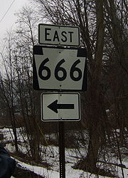
Several highways numbered "666" have experienced high rates of sign theft. According to a 2008 report, this appears to not be the case with PA 666 with a PennDOT spokesperson saying few signs have been stolen.
Pennsylvania
The Commonwealth of Pennsylvania is a U.S. state that is located in the Northeastern and Mid-Atlantic regions of the United States. The state borders Delaware and Maryland to the south, West Virginia to the southwest, Ohio to the west, New York and Ontario, Canada, to the north, and New Jersey to...
. The western terminus of the route is at U.S. Route 62 in the Hickory Township
Hickory Township, Forest County, Pennsylvania
Hickory Township is a township in Forest County, Pennsylvania, United States. As of the 2000 census, the township population was 525.-Geography:...
municipality of East Hickory, and its eastern terminus is at U.S. Route 6 in the hamlet
Hamlet (place)
A hamlet is usually a rural settlement which is too small to be considered a village, though sometimes the word is used for a different sort of community. Historically, when a hamlet became large enough to justify building a church, it was then classified as a village...
of Sheffield in the township of the same name
Sheffield Township, Pennsylvania
Sheffield Township is a township in Warren County, Pennsylvania, United States. The population was 2,346 at the 2000 census.-Geography:According to the United States Census Bureau, the township has a total area of 58.7 square miles , of which, 58.7 square miles of it is land and...
. It cuts through most of Allegheny National Forest
Allegheny National Forest
The Allegheny National Forest is a National Forest located in northwestern Pennsylvania. The forest covers of land. Within the forest is Kinzua Dam, which impounds the Allegheny River to form Allegheny Reservoir. The administrative headquarters for the Allegheny National Forest is located in Warren...
, and is therefore sparsely populated, with the largest settlement along the road being Endeavor, Pennsylvania
Endeavor, Pennsylvania
Endeavor is a community in Hickory Township, Forest County, Pennsylvania, along Allegheny National Forest, on Pennsylvania Route 666. The town is the site of the oldest mill in Pennsylvania, erected in 1834....
. Its official name is the David Zeisberger
David Zeisberger
David Zeisberger was a Moravian clergyman and missionary among the Native Americans in the Thirteen Colonies...
Memorial Highway.
The route was assigned in the 1928 numbering of State Routes in Pennsylvania. The highway originally ended in Nebraska, Pennsylvania until being extended southward along other streets. The route was realigned in 1946 onto its present routing. The highway has remained the same since.
East Hickory to Old PA 666
Pennsylvania Route 666 begins at an intersection with U.S. Route 62U.S. Route 62
U.S. Route 62 runs from the US-Mexico border at El Paso, Texas to Niagara Falls, New York, near the United States-Canada border. It is the only east-west US Route that connects Mexico and Canada.Parts of U.S...
along the banks of the Allegheny River
Allegheny River
The Allegheny River is a principal tributary of the Ohio River; it is located in the Eastern United States. The Allegheny River joins with the Monongahela River to form the Ohio River at the "Point" of Point State Park in Downtown Pittsburgh, Pennsylvania...
in East Hickory. The route progresses eastward, intersecting with East Hickory Road, a dead end street that is part of old U.S. Route 62. With trees and some homes surrounding the highway, PA 666 continues out of East Hickory and into Hickory Township
Hickory Township, Forest County, Pennsylvania
Hickory Township is a township in Forest County, Pennsylvania, United States. As of the 2000 census, the township population was 525.-Geography:...
. The highway heads into Queen, intersecting with two dead-end streets before turning to the southeast. The route quickly leaves Queen, entering a heavily forested area. The trees around the highway are very dense and surround the highway for several miles. The southeastern motion that PA 666 was following becomes a steady east, with the highway making several changes in its direction. There is an intersection with a local road, Yellow Hammer Road, which has access to a small amount of civilization. The road however, is a loop, and merges in soon after. The route continues farther through the dense forestry, intersecting with a woods road. PA 666 continues farther to the southeast, entering a break in the dense forestry.
Old PA 666 to Sheffield
The eastern progression begins to convert to another northeastern one, eventually moving into Balltown. In Balltown, there is a break in the forestry for a small area of civilization. The route heads northward, running along the riverbanks once again, and enters the small municipality of Porkey, Pennsylvania. PA 666 leaves Porkey and makes a U-shaped turn through the forestry. In the U is the municipality of Minister. Afterwards, the route's progression is mainly eastward. The route, running along the riverbanks, turns to the southward, until turning eastward once again. The route continues into Howe TownshipHowe Township, Forest County, Pennsylvania
Howe Township is a township in Forest County, Pennsylvania, United States. The population was 417 at the 2000 census.-Geography:According to the United States Census Bureau, the township has a total area of , all of it land.-Population:...
and quickly leaves, turning to the northeast and into the dense forestry. Several miles later, the route actually makes a northwestern progression, but its for a short time, and the highway goes back to a normal northeastern progression.
There are more and more gaps in the forestry and the highway enters Barnes. In Barnes, PA 666 intersects with Pennsylvania Route 948
Pennsylvania Route 948
Pennsylvania Route 948 is a long state highway located in Elk, Forest, and Warren counties in Pennsylvania. The southern terminus is at PA 255 in Fox Township. The northern terminus is at PA 666 in Sheffield Township.-Elk County:...
's northern terminus. After Barnes, the route becomes more civilized, and the highway passes more homes. Nearing its end, PA 666 re-enters the forested area, leaving quickly. The highway terminates in Sheffield Township
Sheffield Township, Pennsylvania
Sheffield Township is a township in Warren County, Pennsylvania, United States. The population was 2,346 at the 2000 census.-Geography:According to the United States Census Bureau, the township has a total area of 58.7 square miles , of which, 58.7 square miles of it is land and...
, at an intersection with U.S. Route 6
U.S. Route 6
U.S. Route 6 , also called the Grand Army of the Republic Highway, a name that honors an American Civil War veterans association, is a main route of the U.S. Highway system, running east-northeast from Bishop, California to Provincetown, Massachusetts. Until 1964, it continued south from Bishop to...
.
History
Pennsylvania Route 666 was assigned in the mass numbering of state routes in 1928. This routing of PA 666 from Barnes to Nebraska, small municipalities in Forest and Warren Counties. After remaining intact for thirteen years, the highway was extended to Newmansville to terminate at Pennsylvania Route 36Pennsylvania Route 36
Pennsylvania Route 36 is a long state highway located in the U.S. state of Pennsylvania. The southern terminus is at Pennsylvania Route 26 near the Hopewell Township community of Yellow Creek...
and Pennsylvania Route 208
Pennsylvania Route 208
Pennsylvania Route 208 is located in Western Pennsylvania; its western terminus just west of the village of New Bedford in Lawrence County at US 422 and the Ohio state line...
. This southern extension is now Newmansville Road, three quadrant routes, and two township roads. In 1946, PA 666 was extended westward to East Hickory, with the extension to Newmansville being decommissioned.
Several highways numbered "666" have experienced high rates of sign theft. According to a 2008 report, this appears to not be the case with PA 666 with a PennDOT spokesperson saying few signs have been stolen.
Major intersections
See also
- County Route 666 (Atlantic County, New Jersey)
- U.S. Route 491U.S. Route 491U.S. Route 491 is a north–south U.S. Highway serving the Four Corners region of the United States. One of the newest designations in the U.S. Highway System, it was created in 2003 as a renumbering of U.S. Route 666...
(former US 666) - List of highways numbered 666