

U.S. Route 491
Encyclopedia
U.S. Route 491 is a north–south U.S. Highway serving the Four Corners region of the United States. One of the newest designations in the U.S. Highway System, it was created in 2003 as a renumbering of U.S. Route 666 (US 666). With the 666 designation, this road was nicknamed the "Devil's Highway" because of the belief by many Christian
s that 666
is the Number of the Beast
. This Satan
ic connotation, combined with a high fatality rate along the New Mexico portion, convinced some people the highway was cursed. The problem was compounded by persistent sign theft
. These factors led to two efforts to renumber the highway, first by officials in Arizona
, later in New Mexico
. There have been safety improvement projects in recent years, and fatality rates have subsequently decreased.
The highway runs through Colorado
, New Mexico and Utah
, as well as the tribal nations of the Navajo Nation
and Ute Mountain Ute Tribe
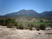
. The highway passes by two mountains considered sacred by native Americans, Ute Mountain
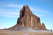
and an extinct volcanic core named Shiprock
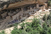
. Other features along the route include Mesa Verde National Park
and Dove Creek
, Colorado, the self-proclaimed pinto-bean capital of the world.
. The former US 666 was the only highway to have passed through each of the Four Corners states, even though it never came near the Four Corners Monument
, which is accessed via US 160
. At several points along US 491, mountain ranges in all of the Four Corners states are visible from a single location. The alignment of the highway is mostly north–south, however the Utah portion is signed east–west.
 US 491 begins at Gallup
, at a junction with Interstate 40
(I-40), and currently runs north along Muñoz Drive. The routing has changed to bypass the downtown area. The original route used 9th Street, starting at US 66. US 491 leaves Gallup and passes north through the eastern half of the Navajo Nation
. Along the way, the road passes through the small tribal communities and trading posts of Tohatchi
, Buffalo Springs, Naschitti
, Sheep Springs
and Newcomb
. The Navajo tribal capital at Window Rock, Arizona
, is just west of the highway corridor, accessed by State Road 264 (NM 264). The largest city served by US 491 in the Navajo Nation is Shiprock
, which takes its name from one of several extinct volcano core
s in the area. Shiprock is known as "the winged rock" in the Navajo language, and the mountain is considered sacred by the Navajo people.
Shiprock is where the US 491 crosses the San Juan River and is briefly concurrent
with US 64
. After passing Shiprock, the route continues north to the Colorado state line. The New Mexico portion has been designated the "John Pinto Highway" by the New Mexico state legislature.
 The New Mexico – Colorado state line is where the highway passes from the Navajo Nation to Ute Mountain Ute
tribal lands. The highway passes to the east of the tribe's namesake, Ute Mountain
, believed to belong to a great warrior god of the Ute People. US 491 proceeds diagonally to the northwest in the extreme southwestern corner of the state. The highway exits tribal lands near Cortez
and Mesa Verde National Park
. After leaving Cortez, the road gradually rises in elevation while proceeding towards Utah. Here, the route features large pinto bean farming regions including Dove Creek, which bills itself as the "pinto bean capital of the world". Canyons of the Ancients National Monument
is located along the ascent, just west of the highway. Along this ascent is an access road for Hovenweep National Monument
at the state line. A portion of the road in Colorado has been designated the Trail of the Ancients
, a National Scenic Byway
, which uses US 491 as an access for these parks and monuments in southwest Colorado.
. Still visible are large farming regions. Upon reaching an elevation of 7000 feet (2,133.6 m), the highway arrives at a weigh station
and reaches the town of Monticello
. US 491 enters the town on Central Street and terminates near the city park at an intersection with US 191, which runs along Main Street. All highways in Utah are codified into law; US 491 is defined at Utah Code Annotated §72-4-137(11).
 Before the Mexican–American War
, when this area was ceded to the United States, the main trade route through this part of Mexico was the Old Spanish Trail
. This trail extended from Santa Fe
, New Mexico to Los Angeles. The trail had multiple routes; however, the main route proceeded north towards Moab
, Utah, one of the few places where the Colorado River
can be crossed without having to traverse steep cliffs. The modern US 491 roughly correlates with the main route of the Old Spanish Trail between Cortez
, Colorado and its northern terminus.
Before 1926, all of modern US 491 existed as state routes. In New Mexico, US 666 absorbed a portion of State Road 32
(NM 32) from Gallup to Shiprock, and completely replaced NM 121 from Shiprock to the Colorado state line. The portion in Colorado was numbered State Highway 108 (SH 108) from the New Mexico state line to Cortez, and SH 10 from Cortez to Utah. At the time, SH 10 traversed the southern portion of Colorado. While most of this route was absorbed by the U.S. Highway System, a portion of it still exists. In Utah, the route was originally numbered State Route 9 (SR 9), which also included what is now US 191 from Monticello to Crescent Junction
. Utah has since re-used the SR 9 designation for a different road.
 The route was upgraded to a U.S. Highway in 1926, as U.S. Route 666. This number was appropriate, per the numbering guidelines for U.S. Highways, as the sixth spur along the highway's parent, U.S. Route 66
, branching off at Gallup
, New Mexico. The number was assigned by the American Association of State Highway Officials (AASHO), a coordinating body that created the U.S. Highway System. At that time, the northern terminus of the route was in Cortez, at an intersection with then US 450 (modern US 160
).
Over time the route became known as the "Devil's Highway", a reference to the Number of the Beast
. This nickname and association made some visitors uncomfortable, as well as making the signs targets for theft
. Because of the highway's number, accidents and other phenomena became repeated as legend. These legends convinced some people the highway was cursed. One unnamed highway patrol officer was quoted in USA Today
as stating a drunk-driving suspect told him, "Triple 6 is evil. Everyone dies on that highway." Skeptics point out that the highway has a lower than average fatality rate in Utah and Colorado, only the New Mexico portion is statistically a dangerous highway. Skeptics further state the high fatality rate in New Mexico can be explained by an inadequate design for the traffic loads at the time. Several people suggested the highway improvements, started at the same time as the renumbering, have done more to reduce fatalities than the renumbering itself.
The curse of US 666 is briefly discussed in Jonathan D. Rosenblum's book, Copper Crucible, which investigates the Arizona Copper Mine Strike of 1983. This strike occurred along the highway near Morenci
, Arizona. The highway was used as a plot element in films and television, including Route 666
, Natural Born Killers
, and Repo Man, as well as a two-part episode of the series Married With Children, titled "Route 666". These pieces are not accurate in portraying the route; for example, one depicts the route in Nevada
.
, at the Mexican border. It ran concurrent
with US 66 for 30 miles (48.3 km) before the turn south. The Arizona portion of the highway is known as the Coronado Trail Scenic Byway, as it approximated the path of the Spanish explorer, Francisco Vásquez de Coronado
. This portion is noted for mountainous terrain, with hairpin turn
s and steep grades, that reaches an altitude of over 9000 feet (2,743.2 m). The curves force a speed limit of 10 miles per hour (16.1 km/h) in spots.
 In 1970, several U.S. Highways in the Four Corners region were re-aligned. As part of this change, US 160 was rerouted west of Cortez
to serve the Four Corners Monument
and enter Arizona instead of Utah. US 666 was extended up part of the old route of US 160 to Monticello, Utah
, at an intersection with then US 163
(now US 191
).
In 1985, the Utah Department of Transportation
petitioned to extend US 666 northwest to Richfield
, but the proposal was rejected. The proposed extension followed SR 95, SR 24
, and SR 119
. A concurrency with US 191 would have been routed through Blanding
and Monticello to connect to the rest of the route. One of the reasons cited for rejecting the proposal was that portions of SR 24 were not built to standards desired for additions to the U.S. Highway System.
 In 1985, the US 66 designation was eliminated, leaving US 666 (and other routes) as "orphans". This fact would be used as a supporting factor in later petitions to renumber the highway. In 1992, the part in Arizona was renumbered as an extension of US 191. This truncated US 666 again at Gallup, New Mexico, now at I-40.
The route in the other three states became U.S. Route 491 in 2003, mainly through efforts of New Mexico Governor Bill Richardson. He requested the change due to the "infamy brought by the inopportune naming of the road". While campaigning for governor, Richardson promised to renumber the highway as part of a larger plan to improve the highway and build relations between New Mexico and the Navajo Nation. Although traditional Navajo culture
does not share the belief of 666 being an evil number, some Navajos had attempted for years to change the number as a way to raise awareness about the dangerous highway. The highway had largely been ignored, with few improvements made since it was first paved. By 1997, US 666 was named one of the 20 most dangerous highways in the United States. Some Navajo leaders were concerned that efforts to reduce poverty on Navajo lands, via promoting tourism and outside investment, were being hampered by the Christian aversion to the number.
In New Mexico's motion to renumber the highway, they selected U.S. Route 393. Since the route came nowhere near US 93
, AASHTO
instead suggested US 491, noting it as a branch of US 191 at Monticello, Utah. Although the next three-digit child of US 91
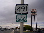
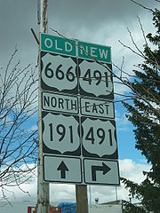
would have been U.S. Route 291, both the 291 and 391 designations were already in use as state route numbers in at least one of the affected states. At the news that the motion had passed, a New Mexico spokesperson stated, "The devil's out of here, and we say goodbye and good riddance." Referring to the motion passing with a different number from what New Mexico requested, another spokesperson responded, "As long as it's not 666 and it's nothing satanic, that's OK." US 666 officially ceased to exist on May 31, 2003, although temporary "New 491 – Old 666" signs were posted after the change to aid travelers using old maps.
 Although sign theft has always been a problem along this highway, thefts reached epidemic proportions when the pending number change was announced. Within days of the announcement, virtually every US 666 sign had been stolen, some for sale on eBay
. Officials in Utah reported that five entire sign assemblies had been cut down with a chainsaw and stolen, while New Mexico officials reported that even signs welded to metal posts, as a theft deterrent, had been stolen. Officials speculated from one scene that someone had intentionally crashed a car into the sign post to break the welds.
The dedication of the "new" highway was postponed until July 30, 2003, to coincide with the start of construction projects to improve safety on the highway. At the dedication George Blue Horse, a Navajo medicine man, performed a ceremony to remove the curse from the highway. In the Navajo language he stated, "The road itself never ends. It goes on generation to generation. The new number is a good one. The new road will be a medicine."
Newspapers and television stations interviewed people along the route about their opinions on the changing of the highway's number. Even some people who believed in the 666 curse disagreed with the change. One went on record as stating highway officials, "are messing with the wrong guy. They're making the devil mad. They should have left the 666 alone." Others were more sarcastic. One Monticello resident stated, "We'll really miss all the potheads stopping and taking pictures of the Route 666 sign." Most residents took pride in living along the Devil's Highway and opposed the change. Some commented that no matter the number they would still call the road the Devil's Highway.
, with grade separation
s at the busiest interchanges. The New Mexico Department of Transportation has noted that, as sections are upgraded, fatality rates improve on the four-lane portions, but remain high on the two-lane portions. As construction has proceeded, the most dangerous portions of the highway have moved to points where the four-lane portion ends, and traffic merges to two lanes. This has caused the department to coordinate the phases of the upgrades to minimize the number of two-lane/four-lane transitions. Construction on the final phase was originally scheduled to begin January 2008, however the state has applied for American Recovery and Reinvestment Act funds to finish the project and completion has been rescheduled for early 2012.
Christianity
Christianity is a monotheistic religion based on the life and teachings of Jesus as presented in canonical gospels and other New Testament writings...
s that 666
666 (number)
666 is the natural number following 665 and preceding 667.- In mathematics :666 is the sum of the first 36 natural numbers 666 (six hundred and sixty-six) is the natural number following 665 and preceding 667.- In mathematics :666 is the sum of the first 36 natural numbers 666 (six hundred and...
is the Number of the Beast
Number of the Beast
The Number of the Beast is a term in the Book of Revelation, of the New Testament, that is associated with the first Beast of Revelation chapter 13, the Beast of the sea. In most manuscripts of the New Testament and in English translations of the Bible, the number of the Beast is...
. This Satan
Satan
Satan , "the opposer", is the title of various entities, both human and divine, who challenge the faith of humans in the Hebrew Bible...
ic connotation, combined with a high fatality rate along the New Mexico portion, convinced some people the highway was cursed. The problem was compounded by persistent sign theft
Street sign theft
Street sign theft occurs when street signs are stolen, often to be used as decorations, but also sometimes to avoid obeying the law by claiming later the sign was not there. Although the theft often seems arbitrary, signs that are unusual or amusing tend to be stolen more frequently...
. These factors led to two efforts to renumber the highway, first by officials in Arizona
Arizona
Arizona ; is a state located in the southwestern region of the United States. It is also part of the western United States and the mountain west. The capital and largest city is Phoenix...
, later in New Mexico
New Mexico
New Mexico is a state located in the southwest and western regions of the United States. New Mexico is also usually considered one of the Mountain States. With a population density of 16 per square mile, New Mexico is the sixth-most sparsely inhabited U.S...
. There have been safety improvement projects in recent years, and fatality rates have subsequently decreased.
The highway runs through Colorado
Colorado
Colorado is a U.S. state that encompasses much of the Rocky Mountains as well as the northeastern portion of the Colorado Plateau and the western edge of the Great Plains...
, New Mexico and Utah
Utah
Utah is a state in the Western United States. It was the 45th state to join the Union, on January 4, 1896. Approximately 80% of Utah's 2,763,885 people live along the Wasatch Front, centering on Salt Lake City. This leaves vast expanses of the state nearly uninhabited, making the population the...
, as well as the tribal nations of the Navajo Nation
Navajo Nation
The Navajo Nation is a semi-autonomous Native American-governed territory covering , occupying all of northeastern Arizona, the southeastern portion of Utah, and northwestern New Mexico...
and Ute Mountain Ute Tribe
Ute Mountain Ute Tribe
The Ute Mountain Ute Tribe is one of three federally recognized tribes of the Ute Nation, and are mostly descendants of the historic Weeminuche Band who moved to the Southern Ute reservation in 1897...
. The highway passes by two mountains considered sacred by native Americans, Ute Mountain
Ute Mountain
Ute Mountain , is a peak within the Ute Mountains, a small mountain range in the southwestern corner of Colorado. It is on the northern edge of the Ute Mountain Ute Reservation. The Reservation forms the southwestern corner of the state and of Montezuma County.Nomenclature for this peak and its...
and an extinct volcanic core named Shiprock
Shiprock
Shiprock is a rock formation rising nearly above the high-desert plain on the Navajo Nation in San Juan County, New Mexico, USA. It has a peak elevation of above the sea level. It lies about southwest of the town of Shiprock, which is named for the peak...
. Other features along the route include Mesa Verde National Park
Mesa Verde National Park
Mesa Verde National Park is a U.S. National Park and UNESCO World Heritage Site located in Montezuma County, Colorado, United States. It was created in 1906 to protect some of the best-preserved cliff dwellings in the world...
and Dove Creek
Dove Creek, Colorado
The Town of Dove Creek is a Statutory Town that is the county seat and the most populous town of Dolores County, Colorado, United States. Dove Creek is the self-proclaimed Pinto Bean Capital of the World...
, Colorado, the self-proclaimed pinto-bean capital of the world.
Route description
US 491 serves the states of New Mexico, Colorado and Utah. Before 1992, US 666 also served Arizona. The Arizona portion was renumbered separately and is now part of US 191U.S. Route 191
U.S. Route 191 is a spur of U.S. Route 91 that has two branches. The southern branch runs for 1,465 miles from Douglas, Arizona on the Mexican border to the southern part of Yellowstone National Park. The northern branch runs for 440 miles from the northern part of Yellowstone National Park to...
. The former US 666 was the only highway to have passed through each of the Four Corners states, even though it never came near the Four Corners Monument
Four Corners Monument
The Four Corners Monument marks the quadripoint in the Southwestern United States where the states of Arizona, Colorado, New Mexico and Utah meet. It is the only point in the United States shared by four states, leading to this area being called the Four Corners region...
, which is accessed via US 160
U.S. Route 160
U.S. Route 160 is a 1,465 mile long east–west United States highway in the Midwestern United States. The western terminus of the route is at U.S. Route 89 five miles west of Tuba City, Arizona. The eastern terminus is at U.S...
. At several points along US 491, mountain ranges in all of the Four Corners states are visible from a single location. The alignment of the highway is mostly north–south, however the Utah portion is signed east–west.
New Mexico
Gallup, New Mexico
- Demographics :As of the census of 2000, there were 20,209 people, 6,810 households, and 4,869 families residing in the city. The population density was 1,513.7 people per square mile...
, at a junction with Interstate 40
Interstate 40 in New Mexico
Interstate 40, a major east–west route of the Interstate Highway System, runs east–west through Albuquerque in the U.S. state of New Mexico. It is the direct replacement for the historic U.S...
(I-40), and currently runs north along Muñoz Drive. The routing has changed to bypass the downtown area. The original route used 9th Street, starting at US 66. US 491 leaves Gallup and passes north through the eastern half of the Navajo Nation
Navajo Nation
The Navajo Nation is a semi-autonomous Native American-governed territory covering , occupying all of northeastern Arizona, the southeastern portion of Utah, and northwestern New Mexico...
. Along the way, the road passes through the small tribal communities and trading posts of Tohatchi
Tohatchi, New Mexico
Tohatchi is a census-designated place in McKinley County, New Mexico, United States. The population was 1,037 at the 2000 census. Tohatchi is located near the border of the Navajo Nation.-Geography:Tohatchi is located at ....
, Buffalo Springs, Naschitti
Naschitti, New Mexico
Naschitti is a census-designated place in San Juan County, New Mexico, United States. The population was 360 at the 2000 census. It is part of the Farmington Metropolitan Statistical Area.-Geography:Naschitti is located at ....
, Sheep Springs
Sheep Springs, New Mexico
Sheep Springs is a census-designated place in San Juan County, New Mexico, United States. The population was 237 at the 2000 census. It is part of the Farmington Metropolitan Statistical Area.-Geography:...
and Newcomb
Newcomb, New Mexico
Newcomb is a census-designated place in San Juan County, New Mexico, United States. The population was 387 at the 2000 census. It is part of the Farmington Metropolitan Statistical Area.-Geography:Newcomb is located at ....
. The Navajo tribal capital at Window Rock, Arizona
Window Rock, Arizona
Window Rock is the seat of government and capital of the Navajo Nation, the largest territory of a sovereign Native American nation in North America. Window Rock contains the Navajo Nation Council, the Navajo Nation Zoological and Botanical Park, as well as the Navajo Nation World War II Memorial...
, is just west of the highway corridor, accessed by State Road 264 (NM 264). The largest city served by US 491 in the Navajo Nation is Shiprock
Shiprock, New Mexico
Shiprock is a census-designated place in San Juan County, New Mexico, United States, on the Navajo reservation. The population was 8,156 at the 2000 census. It is part of the Farmington Metropolitan Statistical Area....
, which takes its name from one of several extinct volcano core
Shiprock
Shiprock is a rock formation rising nearly above the high-desert plain on the Navajo Nation in San Juan County, New Mexico, USA. It has a peak elevation of above the sea level. It lies about southwest of the town of Shiprock, which is named for the peak...
s in the area. Shiprock is known as "the winged rock" in the Navajo language, and the mountain is considered sacred by the Navajo people.
Shiprock is where the US 491 crosses the San Juan River and is briefly concurrent
Concurrency (road)
A concurrency, overlap, or coincidence in a road network is an instance of one physical road bearing two or more different highway, motorway, or other route numbers...
with US 64
U.S. Route 64
U.S. Route 64 is an east–west United States highway that runs for 2,326 miles from eastern North Carolina to just southwest of the Four Corners in northeast Arizona. The western terminus is at U.S. Route 160 in Teec Nos Pos, Arizona. The highway's eastern terminus is at NC 12 and U.S. Route...
. After passing Shiprock, the route continues north to the Colorado state line. The New Mexico portion has been designated the "John Pinto Highway" by the New Mexico state legislature.
Colorado
Ute Mountain Ute Tribe
The Ute Mountain Ute Tribe is one of three federally recognized tribes of the Ute Nation, and are mostly descendants of the historic Weeminuche Band who moved to the Southern Ute reservation in 1897...
tribal lands. The highway passes to the east of the tribe's namesake, Ute Mountain
Ute Mountain
Ute Mountain , is a peak within the Ute Mountains, a small mountain range in the southwestern corner of Colorado. It is on the northern edge of the Ute Mountain Ute Reservation. The Reservation forms the southwestern corner of the state and of Montezuma County.Nomenclature for this peak and its...
, believed to belong to a great warrior god of the Ute People. US 491 proceeds diagonally to the northwest in the extreme southwestern corner of the state. The highway exits tribal lands near Cortez
Cortez, Colorado
The city of Cortez is a Home Rule Municipality that is the county seat and the most populous city of Montezuma County, Colorado, United States. The city population was 8,482 at the 2010 census...
and Mesa Verde National Park
Mesa Verde National Park
Mesa Verde National Park is a U.S. National Park and UNESCO World Heritage Site located in Montezuma County, Colorado, United States. It was created in 1906 to protect some of the best-preserved cliff dwellings in the world...
. After leaving Cortez, the road gradually rises in elevation while proceeding towards Utah. Here, the route features large pinto bean farming regions including Dove Creek, which bills itself as the "pinto bean capital of the world". Canyons of the Ancients National Monument
Canyons of the Ancients National Monument
Canyons of the Ancients National Monument is located in the southwestern region of the U.S. state of Colorado, and is managed by the U.S. Bureau of Land Management, an agency within the U.S. Department of the Interior...
is located along the ascent, just west of the highway. Along this ascent is an access road for Hovenweep National Monument
Hovenweep National Monument
Hovenweep National Monument is located on land in southwestern Colorado and southeastern Utah, located between Cortez, Colorado and Blanding, Utah on the Cajon Mesa of the Great Sage Plain...
at the state line. A portion of the road in Colorado has been designated the Trail of the Ancients
Trail of the Ancients
The Trail of the Ancients is an National Scenic Byway located in the states of Colorado and Utah. The route highlights the archaeological and cultural history of southwestern Native American peoples, and traverses the widely diverse geological landscape of the Four Corners region...
, a National Scenic Byway
National Scenic Byway
A National Scenic Byway is a road recognized by the United States Department of Transportation for its archeological, cultural, historic, natural, recreational, and/or scenic qualities. The program was established by Congress in 1991 to preserve and protect the nation's scenic but often...
, which uses US 491 as an access for these parks and monuments in southwest Colorado.
Utah
Once in Utah, US 491 gradually ascends to the Abajo MountainsAbajo Mountains
The Abajo Mountains, also called the Blue Mountains, is a small mountain range west of Monticello, Utah, south of Canyonlands National Park and north of Blanding, Utah. The mountain range is located within the Manti-La Sal National Forest...
. Still visible are large farming regions. Upon reaching an elevation of 7000 feet (2,133.6 m), the highway arrives at a weigh station
Weigh station
A weigh station is a checkpoint along a highway to inspect vehicular weights. Usually, trucks and commercial vehicles are subject to the inspection....
and reaches the town of Monticello
Monticello, Utah
Monticello is a city located in San Juan County, Utah, and is the county seat. It is the second most populous city in San Juan County, with a population of 1,958 at the 2000 census. The Monticello area was settled in July 1887 by pioneers from The Church of Jesus Christ of Latter-day Saints...
. US 491 enters the town on Central Street and terminates near the city park at an intersection with US 191, which runs along Main Street. All highways in Utah are codified into law; US 491 is defined at Utah Code Annotated §72-4-137(11).
Pre-1926
Mexican–American War
The Mexican–American War, also known as the First American Intervention, the Mexican War, or the U.S.–Mexican War, was an armed conflict between the United States and Mexico from 1846 to 1848 in the wake of the 1845 U.S...
, when this area was ceded to the United States, the main trade route through this part of Mexico was the Old Spanish Trail
Old Spanish Trail (trade route)
The Old Spanish Trail is a historical trade route which connected the northern New Mexico settlements near or in Santa Fe, New Mexico with that of Los Angeles, California and southern California. Approximately long, it ran through areas of high mountains, arid deserts, and deep canyons. It is...
. This trail extended from Santa Fe
Santa Fe, New Mexico
Santa Fe is the capital of the U.S. state of New Mexico. It is the fourth-largest city in the state and is the seat of . Santa Fe had a population of 67,947 in the 2010 census...
, New Mexico to Los Angeles. The trail had multiple routes; however, the main route proceeded north towards Moab
Moab, Utah
Moab is a city in Grand County, in eastern Utah, in the western United States. The population was 4,779 at the 2000 census. It is the county seat and largest city in Grand County. Moab hosts a large number of tourists every year, mostly visitors to the nearby Arches and Canyonlands National Parks...
, Utah, one of the few places where the Colorado River
Colorado River
The Colorado River , is a river in the Southwestern United States and northwestern Mexico, approximately long, draining a part of the arid regions on the western slope of the Rocky Mountains. The watershed of the Colorado River covers in parts of seven U.S. states and two Mexican states...
can be crossed without having to traverse steep cliffs. The modern US 491 roughly correlates with the main route of the Old Spanish Trail between Cortez
Cortez, Colorado
The city of Cortez is a Home Rule Municipality that is the county seat and the most populous city of Montezuma County, Colorado, United States. The city population was 8,482 at the 2010 census...
, Colorado and its northern terminus.
Before 1926, all of modern US 491 existed as state routes. In New Mexico, US 666 absorbed a portion of State Road 32
New Mexico State Road 32
State Road 32 is a state highway in Catron County in the U.S. state of New Mexico. It is long, and stretches from Apache Creek in the south to Quemado in the north.-Route description:...
(NM 32) from Gallup to Shiprock, and completely replaced NM 121 from Shiprock to the Colorado state line. The portion in Colorado was numbered State Highway 108 (SH 108) from the New Mexico state line to Cortez, and SH 10 from Cortez to Utah. At the time, SH 10 traversed the southern portion of Colorado. While most of this route was absorbed by the U.S. Highway System, a portion of it still exists. In Utah, the route was originally numbered State Route 9 (SR 9), which also included what is now US 191 from Monticello to Crescent Junction
Crescent Junction, Utah
Crescent Junction is a small unincorporated community within Grand County in the eastern part of the U.S. state of Utah. The community is located at above sea level. Most highway maps use the name Crescent Junction, as the name given to the junction of Interstate 70 and U.S. Route 191...
. Utah has since re-used the SR 9 designation for a different road.
U.S. Route 666
U.S. Route 66
U.S. Route 66 was a highway within the U.S. Highway System. One of the original U.S. highways, Route 66 was established on November 11, 1926 -- with road signs erected the following year...
, branching off at Gallup
Gallup, New Mexico
- Demographics :As of the census of 2000, there were 20,209 people, 6,810 households, and 4,869 families residing in the city. The population density was 1,513.7 people per square mile...
, New Mexico. The number was assigned by the American Association of State Highway Officials (AASHO), a coordinating body that created the U.S. Highway System. At that time, the northern terminus of the route was in Cortez, at an intersection with then US 450 (modern US 160
U.S. Route 160
U.S. Route 160 is a 1,465 mile long east–west United States highway in the Midwestern United States. The western terminus of the route is at U.S. Route 89 five miles west of Tuba City, Arizona. The eastern terminus is at U.S...
).
Over time the route became known as the "Devil's Highway", a reference to the Number of the Beast
Number of the Beast
The Number of the Beast is a term in the Book of Revelation, of the New Testament, that is associated with the first Beast of Revelation chapter 13, the Beast of the sea. In most manuscripts of the New Testament and in English translations of the Bible, the number of the Beast is...
. This nickname and association made some visitors uncomfortable, as well as making the signs targets for theft
Street sign theft
Street sign theft occurs when street signs are stolen, often to be used as decorations, but also sometimes to avoid obeying the law by claiming later the sign was not there. Although the theft often seems arbitrary, signs that are unusual or amusing tend to be stolen more frequently...
. Because of the highway's number, accidents and other phenomena became repeated as legend. These legends convinced some people the highway was cursed. One unnamed highway patrol officer was quoted in USA Today
USA Today
USA Today is a national American daily newspaper published by the Gannett Company. It was founded by Al Neuharth. The newspaper vies with The Wall Street Journal for the position of having the widest circulation of any newspaper in the United States, something it previously held since 2003...
as stating a drunk-driving suspect told him, "Triple 6 is evil. Everyone dies on that highway." Skeptics point out that the highway has a lower than average fatality rate in Utah and Colorado, only the New Mexico portion is statistically a dangerous highway. Skeptics further state the high fatality rate in New Mexico can be explained by an inadequate design for the traffic loads at the time. Several people suggested the highway improvements, started at the same time as the renumbering, have done more to reduce fatalities than the renumbering itself.
The curse of US 666 is briefly discussed in Jonathan D. Rosenblum's book, Copper Crucible, which investigates the Arizona Copper Mine Strike of 1983. This strike occurred along the highway near Morenci
Morenci, Arizona
Morenci is a census-designated place in Greenlee County, Arizona, United States. The population was 1,879 at the 2000 census. It is part of the Safford Micropolitan Statistical Area...
, Arizona. The highway was used as a plot element in films and television, including Route 666
Route 666 (film)
Route 666 is a 2001 action/horror film directed by William Wesley. It stars Lou Diamond Phillips, Lori Petty, Steven Williams, L.Q. Jones, Dale Midkiff, Alex McArthur, and Mercedes Colon.-Plot:...
, Natural Born Killers
Natural Born Killers
Natural Born Killers is a 1994 crime/black comedy film directed by Oliver Stone about two victims of traumatic childhoods who became lovers and psychopathic serial killers, and are irresponsibly glorified by the mass media...
, and Repo Man, as well as a two-part episode of the series Married With Children, titled "Route 666". These pieces are not accurate in portraying the route; for example, one depicts the route in Nevada
Nevada
Nevada is a state in the western, mountain west, and southwestern regions of the United States. With an area of and a population of about 2.7 million, it is the 7th-largest and 35th-most populous state. Over two-thirds of Nevada's people live in the Las Vegas metropolitan area, which contains its...
.
Extensions into Arizona and Utah
By 1942, the southern terminus of the route was extended to Douglas, ArizonaDouglas, Arizona
Douglas is a city in Cochise County, Arizona, United States. Douglas has a border crossing with Mexico and a history of mining.The population was 14,312 at the 2000 census...
, at the Mexican border. It ran concurrent
Concurrency (road)
A concurrency, overlap, or coincidence in a road network is an instance of one physical road bearing two or more different highway, motorway, or other route numbers...
with US 66 for 30 miles (48.3 km) before the turn south. The Arizona portion of the highway is known as the Coronado Trail Scenic Byway, as it approximated the path of the Spanish explorer, Francisco Vásquez de Coronado
Francisco Vásquez de Coronado
Francisco Vásquez de Coronado y Luján was a Spanish conquistador, who visited New Mexico and other parts of what are now the southwestern United States between 1540 and 1542...
. This portion is noted for mountainous terrain, with hairpin turn
Hairpin turn
A hairpin turn , named for its resemblance to a hairpin/bobby pin, is a bend in a road with a very acute inner angle, making it necessary for an oncoming vehicle to turn almost 180° to continue on the road. Such turns in ramps and trails may be called switchbacks in American English, by analogy...
s and steep grades, that reaches an altitude of over 9000 feet (2,743.2 m). The curves force a speed limit of 10 miles per hour (16.1 km/h) in spots.
Cortez, Colorado
The city of Cortez is a Home Rule Municipality that is the county seat and the most populous city of Montezuma County, Colorado, United States. The city population was 8,482 at the 2010 census...
to serve the Four Corners Monument
Four Corners Monument
The Four Corners Monument marks the quadripoint in the Southwestern United States where the states of Arizona, Colorado, New Mexico and Utah meet. It is the only point in the United States shared by four states, leading to this area being called the Four Corners region...
and enter Arizona instead of Utah. US 666 was extended up part of the old route of US 160 to Monticello, Utah
Monticello, Utah
Monticello is a city located in San Juan County, Utah, and is the county seat. It is the second most populous city in San Juan County, with a population of 1,958 at the 2000 census. The Monticello area was settled in July 1887 by pioneers from The Church of Jesus Christ of Latter-day Saints...
, at an intersection with then US 163
U.S. Route 163
U.S. Route 163 is a U.S. Highway that runs from US 160 northward to US 191 in the U.S. states of Arizona and Utah. The southernmost of its length is within the Navajo Nation. The highway forms part of the Trail of the Ancients, a National Scenic Byway...
(now US 191
U.S. Route 191
U.S. Route 191 is a spur of U.S. Route 91 that has two branches. The southern branch runs for 1,465 miles from Douglas, Arizona on the Mexican border to the southern part of Yellowstone National Park. The northern branch runs for 440 miles from the northern part of Yellowstone National Park to...
).
In 1985, the Utah Department of Transportation
Utah Department of Transportation
The Utah Department of Transportation is an agency of the state government for the U.S. state of Utah. The agency is usually referred to by its initials UDOT . UDOT is charged with maintaining the network of state highways in Utah. The agency is headquartered in the Calvin L. Rampton state office...
petitioned to extend US 666 northwest to Richfield
Richfield, Utah
Richfield is a city in and the county seat of Sevier County, Utah, in the United States, and is the largest city in southern-central Utah. As of the 2010 census, the city population was 7,551. It lies in the Mormon Corridor, just off of Interstate 70 about 40 miles east of its junction with...
, but the proposal was rejected. The proposed extension followed SR 95, SR 24
Utah State Route 24
State Route 24 is a state highway in south central Utah which runs south from Salina through Sevier County then east through Wayne County and north east through Emery County...
, and SR 119
Utah State Route 119
State Route 119 is a state highway in the U.S. state of Utah, connecting Richfield to Glenwood and SR-24.-Route description:SR-119 begins on the eastern outskirts of Richfield at SR-118 , which follows 300 North east from downtown Richfield and curves northeast towards Sigurd. The western half of...
. A concurrency with US 191 would have been routed through Blanding
Blanding, Utah
Blanding is a city in San Juan County, Utah, United States. The population was 3,162 at the 2000 census, making it the most populated city in San Juan County. It was settled in the late 19th century by Mormon settlers, predominantly from the famed Hole-In-The-Rock expedition...
and Monticello to connect to the rest of the route. One of the reasons cited for rejecting the proposal was that portions of SR 24 were not built to standards desired for additions to the U.S. Highway System.
Elimination and renumbering of US 666
The route in the other three states became U.S. Route 491 in 2003, mainly through efforts of New Mexico Governor Bill Richardson. He requested the change due to the "infamy brought by the inopportune naming of the road". While campaigning for governor, Richardson promised to renumber the highway as part of a larger plan to improve the highway and build relations between New Mexico and the Navajo Nation. Although traditional Navajo culture
Navajo people
The Navajo of the Southwestern United States are the largest single federally recognized tribe of the United States of America. The Navajo Nation has 300,048 enrolled tribal members. The Navajo Nation constitutes an independent governmental body which manages the Navajo Indian reservation in the...
does not share the belief of 666 being an evil number, some Navajos had attempted for years to change the number as a way to raise awareness about the dangerous highway. The highway had largely been ignored, with few improvements made since it was first paved. By 1997, US 666 was named one of the 20 most dangerous highways in the United States. Some Navajo leaders were concerned that efforts to reduce poverty on Navajo lands, via promoting tourism and outside investment, were being hampered by the Christian aversion to the number.
In New Mexico's motion to renumber the highway, they selected U.S. Route 393. Since the route came nowhere near US 93
U.S. Route 93
U.S. Route 93 is a major north–south United States highway in the western United States. The southern terminus is at U.S. Route 60 in Wickenburg, Arizona. The northern terminus is at the Canadian border north of Eureka in Lincoln County, Montana, where the roadway continues into Roosville,...
, AASHTO
American Association of State Highway and Transportation Officials
AASHTO, the American Association of State Highway and Transportation Officials, is a standards setting body which publishes specifications, test protocols and guidelines which are used in highway design and construction throughout the United States...
instead suggested US 491, noting it as a branch of US 191 at Monticello, Utah. Although the next three-digit child of US 91
U.S. Route 91
U.S. Route 91 is a north–south United States highway. The highway currently serves as a connection between the Cache Valley area of Utah and Idaho to the Salt Lake and Idaho Falls population centers. Prior the mid-1970s, U.S. 91 was an international commerce route from Long Beach, California...
would have been U.S. Route 291, both the 291 and 391 designations were already in use as state route numbers in at least one of the affected states. At the news that the motion had passed, a New Mexico spokesperson stated, "The devil's out of here, and we say goodbye and good riddance." Referring to the motion passing with a different number from what New Mexico requested, another spokesperson responded, "As long as it's not 666 and it's nothing satanic, that's OK." US 666 officially ceased to exist on May 31, 2003, although temporary "New 491 – Old 666" signs were posted after the change to aid travelers using old maps.
EBay
eBay Inc. is an American internet consumer-to-consumer corporation that manages eBay.com, an online auction and shopping website in which people and businesses buy and sell a broad variety of goods and services worldwide...
. Officials in Utah reported that five entire sign assemblies had been cut down with a chainsaw and stolen, while New Mexico officials reported that even signs welded to metal posts, as a theft deterrent, had been stolen. Officials speculated from one scene that someone had intentionally crashed a car into the sign post to break the welds.
The dedication of the "new" highway was postponed until July 30, 2003, to coincide with the start of construction projects to improve safety on the highway. At the dedication George Blue Horse, a Navajo medicine man, performed a ceremony to remove the curse from the highway. In the Navajo language he stated, "The road itself never ends. It goes on generation to generation. The new number is a good one. The new road will be a medicine."
Newspapers and television stations interviewed people along the route about their opinions on the changing of the highway's number. Even some people who believed in the 666 curse disagreed with the change. One went on record as stating highway officials, "are messing with the wrong guy. They're making the devil mad. They should have left the 666 alone." Others were more sarcastic. One Monticello resident stated, "We'll really miss all the potheads stopping and taking pictures of the Route 666 sign." Most residents took pride in living along the Devil's Highway and opposed the change. Some commented that no matter the number they would still call the road the Devil's Highway.
Post-renumbering
Since the renumbering in 2003, portions of US 491 in New Mexico have been upgraded to a four-lane divided highwayDivided Highway
Divided Highway is a compilation album by American rock band The Doobie Brothers, released in 2003. . All tracks are taken from the albums Cycles and Brotherhood .-Track listing:...
, with grade separation
Grade separation
Grade separation is the method of aligning a junction of two or more transport axes at different heights so that they will not disrupt the traffic flow on other transit routes when they cross each other. The composition of such transport axes does not have to be uniform; it can consist of a...
s at the busiest interchanges. The New Mexico Department of Transportation has noted that, as sections are upgraded, fatality rates improve on the four-lane portions, but remain high on the two-lane portions. As construction has proceeded, the most dangerous portions of the highway have moved to points where the four-lane portion ends, and traffic merges to two lanes. This has caused the department to coordinate the phases of the upgrades to minimize the number of two-lane/four-lane transitions. Construction on the final phase was originally scheduled to begin January 2008, however the state has applied for American Recovery and Reinvestment Act funds to finish the project and completion has been rescheduled for early 2012.
Major intersections
- Note: Utah mileposts are reversed in this table to maintain continuity.
See also
- HexakosioihexekontahexaphobiaHexakosioihexekontahexaphobiaHexakosioihexekontahexaphobia is the fear...
, fear of the number 666 - List of highways numbered 666
- List of highways numbered 491