
Pennsylvania Route 664
Encyclopedia
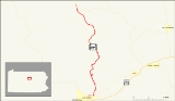
Pennsylvania Route 664 (designated by the Pennsylvania Department of Transportation
as SR 0664) is a 17.65 miles (28.4 km) long state highway
located in Clinton
and Lycoming
counties in Pennsylvania
. The southern terminus is at State Route 120
in Lock Haven
, while the northern terminus is at State Route 44
on the Clinton-Lycoming county line in the community of Haneyville. The route passes through small communities, but does not intersect with any other legislated highways in the area.
The route was assigned in 1930, two years after a majority of state routes were assigned, and had continuous repavings done from 1935 to 1966. There have been no changes in road alignment since its inception.
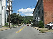 State Route 664 begins at an intersection with State Route 120 in community of Lock Haven. The highway progresses northward, leaving the community limits of Lock Haven. After the intersection with East Water Street, State Route 664 crosses the West Branch of the Susquehanna River
. The bridge over the branch of river was constructed in 1986. At the intersection with Farrandsville Road, the highway turns eastward, paralleling the river. Nearing State Route 150
, the highway turns northward and into Dunnstown. While winding around a few curves, State Route 664 intersects with Armory Drive, an access road to a local armory. The route's surroundings are highly developed in Dunnstown, with the highway passes along homes. At the intersection with Aikey Street, State Route 664 leaves Dunnstown and proceeds northward.
The highway passes some homes and forests north of Dunnstown, entering Woodward Township soon after. At the intersection with Township Road 406, State Route 664 starts winding in several directions, but following a northward basis. This continues until the intersection with Arbutus Drive, where it heads straight to the northwest. At a clearing in a nearby forest, State Route 664 enters the community of Swissdale. The stay in the community is short, with the highway leaving after a few blocks. Just north of Swissdale, State Route 664 makes a long hairpin turn, curving from east to west before turning north once again. Just after the intersection with Honey Suckle Lane, State Route 664 progresses towards Haneyville.
The next stretch of State Route 664 is full of bends, and the highway continuously turns at a constant rate. At an intersection with another Honey Suckle Lane, the highway starts its northwestern progression once again. This changes again when Tedrow Lane begins paralleling the highway. Now following a steady northeastern alignment, the highway continues through the large patches of trees south of Haneyville. At Little Plum Run Road, the highway turns onto a steady northward alignment. The highway continues through the trees for a while, continuing northward on its way to Gallagher Township.
At a bend in the highway, there is a small patch of development, with a few houses near the highway. At the intersection with Township Road 529, State Route 664 enters Gallagher Township
. Eventually, the large patch of forests in the surroundings come towards a clearing, where the highway intersects with Old Dirt Road. After crossing a stream, State Route 664 gains the moniker of the Coudersport
Pike. The highway passes a small patch of development, reaching another clearing in the forest. After entering another forest, State Route 664 ends at an intersection with State Route 44 in the community of Haneyville.
in 1928. The highway itself took several years to transition from gravel to actual pavement. The first segment, which occurred in 1935, was from Little Plum Run Road and northward. The second segment was in 1936, when the Pennsylvania Department of Highways paved the piece of State Route 664 from a point just south of Gallagher to the Gallagher Township line. In 1938, the third segment, from Swissdale to Gallagher Township was paved.
In 1949, the Department of Highways paved the piece of State Route 664 from Gallagher Township to the Lycoming County line. In 1951, the section between Swissdale and Little Plum Run Road was paved once again. Two years after that, the section from the Lycoming County line to State Route 44 was improved in its condition. That lone section was improved in 1966. There have been no recorded changes in alignment since its 1930 assignment.
Pennsylvania Department of Transportation
The Pennsylvania Department of Transportation oversees transportation issues in the Commonwealth of Pennsylvania. The administrator of PennDOT is the Pennsylvania Secretary of Transportation, currently Barry Schoch Presently, PennDOT supports over of state roads and highways, about 25,000...
as SR 0664) is a 17.65 miles (28.4 km) long state highway
State highway
State highway, state road or state route can refer to one of three related concepts, two of them related to a state or provincial government in a country that is divided into states or provinces :#A...
located in Clinton
Clinton County, Pennsylvania
As of the census of 2000, there were 37,914 people, 14,773 households, and 9,927 families residing in the county. The population density was 43 people per square mile . There were 18,166 housing units at an average density of 20 per square mile...
and Lycoming
Lycoming County, Pennsylvania
-Appalachian Mountains and Allegheny Plateau:Lycoming County is divided between the Appalachian Mountains in the south, the dissected Allegheny Plateau in the north and east, and the valley of the West Branch Susquehanna River between these.-West Branch Susquehanna River:The West Branch of the...
counties in Pennsylvania
Pennsylvania
The Commonwealth of Pennsylvania is a U.S. state that is located in the Northeastern and Mid-Atlantic regions of the United States. The state borders Delaware and Maryland to the south, West Virginia to the southwest, Ohio to the west, New York and Ontario, Canada, to the north, and New Jersey to...
. The southern terminus is at State Route 120
Pennsylvania Route 120
Pennsylvania Route 120 is a state highway in the U.S. state of Pennsylvania, running from U.S. Route 219 in Ridgway east to U.S. Route 220 in Lock Haven.-Bucktail State Park Natural Area:...
in Lock Haven
Lock Haven, Pennsylvania
The city of Lock Haven is the county seat of Clinton County, in the U.S. state of Pennsylvania. Located near the confluence of the West Branch Susquehanna River and Bald Eagle Creek, it is the principal city of the Lock Haven, Pennsylvania, micropolitan statistical area, itself part of the...
, while the northern terminus is at State Route 44
Pennsylvania Route 44
Pennsylvania Route 44 is a -long state highway in the U.S. state of Pennsylvania. The route is designated from Interstate 80 and Pennsylvania Route 42 in Buckhorn to the New York state line near New York State Route 417 in Ceres Township....
on the Clinton-Lycoming county line in the community of Haneyville. The route passes through small communities, but does not intersect with any other legislated highways in the area.
The route was assigned in 1930, two years after a majority of state routes were assigned, and had continuous repavings done from 1935 to 1966. There have been no changes in road alignment since its inception.
Route description
Susquehanna River
The Susquehanna River is a river located in the northeastern United States. At long, it is the longest river on the American east coast that drains into the Atlantic Ocean, and with its watershed it is the 16th largest river in the United States, and the longest river in the continental United...
. The bridge over the branch of river was constructed in 1986. At the intersection with Farrandsville Road, the highway turns eastward, paralleling the river. Nearing State Route 150
Pennsylvania Route 150
Pennsylvania Route 150 is a 41.10-mile-long highway in Central Pennsylvania. Its northern terminus is at U.S. Route 220 in Avis, Pennsylvania...
, the highway turns northward and into Dunnstown. While winding around a few curves, State Route 664 intersects with Armory Drive, an access road to a local armory. The route's surroundings are highly developed in Dunnstown, with the highway passes along homes. At the intersection with Aikey Street, State Route 664 leaves Dunnstown and proceeds northward.
The highway passes some homes and forests north of Dunnstown, entering Woodward Township soon after. At the intersection with Township Road 406, State Route 664 starts winding in several directions, but following a northward basis. This continues until the intersection with Arbutus Drive, where it heads straight to the northwest. At a clearing in a nearby forest, State Route 664 enters the community of Swissdale. The stay in the community is short, with the highway leaving after a few blocks. Just north of Swissdale, State Route 664 makes a long hairpin turn, curving from east to west before turning north once again. Just after the intersection with Honey Suckle Lane, State Route 664 progresses towards Haneyville.
The next stretch of State Route 664 is full of bends, and the highway continuously turns at a constant rate. At an intersection with another Honey Suckle Lane, the highway starts its northwestern progression once again. This changes again when Tedrow Lane begins paralleling the highway. Now following a steady northeastern alignment, the highway continues through the large patches of trees south of Haneyville. At Little Plum Run Road, the highway turns onto a steady northward alignment. The highway continues through the trees for a while, continuing northward on its way to Gallagher Township.
At a bend in the highway, there is a small patch of development, with a few houses near the highway. At the intersection with Township Road 529, State Route 664 enters Gallagher Township
Gallagher Township, Pennsylvania
Gallagher Township is a township in Clinton County, Pennsylvania, United States. The population was 340 at the 2000 census.-Geography:According to the United States Census Bureau, the township has a total area of , all of it land.-Demographics:...
. Eventually, the large patch of forests in the surroundings come towards a clearing, where the highway intersects with Old Dirt Road. After crossing a stream, State Route 664 gains the moniker of the Coudersport
Coudersport, Pennsylvania
Coudersport is a borough in Potter County, Pennsylvania, east by south of Erie on the Allegheny River. The populations were these: 1,530 in 1890; 3,217 in 1900; and 3,100 in 1910. The population was 2,650 at the 2000 census...
Pike. The highway passes a small patch of development, reaching another clearing in the forest. After entering another forest, State Route 664 ends at an intersection with State Route 44 in the community of Haneyville.
History
State Route 664 was assigned two years after the mass numbering of state routes in PennsylvaniaPennsylvania
The Commonwealth of Pennsylvania is a U.S. state that is located in the Northeastern and Mid-Atlantic regions of the United States. The state borders Delaware and Maryland to the south, West Virginia to the southwest, Ohio to the west, New York and Ontario, Canada, to the north, and New Jersey to...
in 1928. The highway itself took several years to transition from gravel to actual pavement. The first segment, which occurred in 1935, was from Little Plum Run Road and northward. The second segment was in 1936, when the Pennsylvania Department of Highways paved the piece of State Route 664 from a point just south of Gallagher to the Gallagher Township line. In 1938, the third segment, from Swissdale to Gallagher Township was paved.
In 1949, the Department of Highways paved the piece of State Route 664 from Gallagher Township to the Lycoming County line. In 1951, the section between Swissdale and Little Plum Run Road was paved once again. Two years after that, the section from the Lycoming County line to State Route 44 was improved in its condition. That lone section was improved in 1966. There have been no recorded changes in alignment since its 1930 assignment.