
Pennsylvania Route 39
Encyclopedia
Pennsylvania Route 39 (PA 39) is a 17.68 miles (28.45 km) long east–west state highway
in Dauphin County
, Pennsylvania
, United States
. It starts at North Front Street north of Harrisburg
and ends at U.S. Route 322 and U.S. Route 422
near Hummelstown
. PA 39 is known as Linglestown Road west of Interstate 81, as Hershey Road from I-81 to Hersheypark Drive, and as Hersheypark Drive south of Hershey Road. The route passes through the northern and eastern suburbs of Harrisburg and passes by Hersheypark
and Giant Center
.
The Linglestown
–Manada Hill portion of PA 39 was originally part of Legislative Route 140, one of hundreds of unsigned legislative route
s created by the Sproul Road Bill in 1911. LR 140 was later rerouted to bypass Linglestown to the south, and the Paxtonia
– Lower Paxton Township
portion of its former routing became LR 140A. This legislative route was initially signed solely as PA 894
. PA 39 was assigned in the 1930s to the portion of LR 140A east of Linglestown—overlapping PA 894—and also to LR 22006 between the Susquehanna River
and Manadahill. The PA 894 designation was later removed.
PA 39 was extended southward to the vicinity of Hummelstown in two stages. The first extension during the 1940s shifted PA 39's eastern terminus to the junction of Hershey Road and Allentown Boulevard (U.S. Route 22) south of Manadahill. Its terminus was moved to its present location in the early 1960s. Only local realignments and improvements have occurred since.
in the Dauphin County
township of Susquehanna
north of Harrisburg
. It heads northeast as Linglestown Road through a densely populated neighborhood and widens from two to four lanes as it approaches an interchange with U.S. Route 22 and U.S. Route 322 at the northern tip of Wildwood Lake. East of the exit, the highway reverts back to two lanes and passes through the predominantly residential northern suburbs of Harrisburg. It intersects North Progress Avenue prior to passing into Lower Paxton Township
.
 West of the village of Linglestown
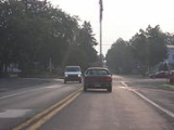
, PA 39 intersects Colonial Road (unsigned State Route 3017), a connector highway between PA 39 and US 22, which follows a routing parallel to PA 39 2.5 miles (4 km) to the south. PA 39 continues east to Linglestown, where it intersects North Mountain Road at an unorthodox intersection featuring a flagpole in its center. Outside of the village, the amount of development along the highway declines as PA 39 passes through areas of forests and open fields. It enters West Hanover Township
upon crossing Beaver Creek
and interchanges with Interstate 81 at exit 77. Just east of the interchange, PA 39 intersects Jonestown Road and changes names from Linglestown Road to Hershey Road.
Unlike Linglestown Road, which followed a mostly east–west alignment, Hershey Road has a north–south orientation. It heads south from Jonestown Road to intersect US 22 near Skyline View
, here an at-grade
roadway named Allentown Boulevard. PA 39 continues onward, snaking southeastward through a rural region of Dauphin County to the vicinity of Hershey
. During this stretch, it passes through South Hanover Township
and serves the communities of Hanoverale
and Union Deposit. The route crosses into Derry Township
after crossing over Swatara Creek
, then intersects Hersheytown Road near the creek's southern bank. Hershey Road continues south from here as Park Boulevard, a service road for Giant Center
and Hersheypark
; however, PA 39 veers westward onto Hersheytown Road and bypasses Giant Center to the north. This portion of PA 39 is four lanes wide, the first significant portion of PA 39 to be since the area surrounding I-81.
PA 39 heads southwest in a circuitous fashion, bypassing the village of Hershey to the north and west. It passes under a Norfolk Southern Railway
line, then enters a highly developed area east of the borough
of Hummelstown
. Here, PA 39 intersects Walton Avenue, a local street connecting PA 39 to the village. This is the final junction along PA 39 as the route ends 0.3 mile (0.482802 km) later at a modified cloverleaf interchange
with US 322 and U.S. Route 422
.
extending from Harrisburg
in the west to Pottsville
in the east, was created on May 31, 1911, through the Sproul Road Bill, which established the initial set of legislative routes throughout Pennsylvania
. LR 140 entered Linglestown on North Mountain Road, then turned to follow modern PA 39 from Linglestown to Manadahill, where it veered onto Jonestown Road. LR 140 was realigned by 1926 to follow a direct route between Paxtonia and Manadahill via Jonestown Road. The portion of former LR 140 from Paxtonia to the Lower Paxton
– West Hanover
township line was then redesignated as LR 140A. All of LR 140A was designated as the signed PA 894
by 1930.
In the Omnibus Road Bill Act of 1931, LR 22006 was established, spanning the portion of current PA 39 from the Susquehanna River
north of Harrisburg
to Hanoverdale at the West Hanover – South Hanover
township line. The remainder of current PA 39 north of Swatara Creek
was a state-aid route designated A-306, which ran from South Hanover Township to Union Deposit.
near Piketown. The overlap between PA 39 and PA 894 was eliminated in the 1940s when the entirety of the PA 894 designation was removed.
The first change to PA 39's routing came in the 1940s. During this time, U.S. Route 22 was rerouted through Dauphin
and Lebanon County
to follow Allentown Boulevard instead of Jonestown Road. As a result, PA 39 was extended a short distance southward along LR 22006 on what is now Jonestown Road, Harper Drive, and Hershey Road to meet the new alignment of US 22 south of Manadahill. It was extended further southward on LR 22006 and A-306, as well as parts of Legislative Routes 22011 and 22013 in the early 1960s to a new terminus at U.S. Route 322 and U.S. Route 422
near Hummelstown
. At the time, it was routed on Hanover Street in the vicinity of Union Deposit. The portion of Hanover Street south of Canal Street had previously been part of PA 340
from the 1930s to the early-to-mid-1950s.
A new highway around the eastern fringe of Union Deposit was constructed in the late 1960s and opened to traffic as a realignment of PA 39 by 1970. Park Boulevard in Hershey
was rerouted by 1990 to intersect the new bypass and provide a direct connection between Hersheypark
and PA 39. A smaller-scale rerouting of PA 39 in Manadahill was completed by 1972, placing PA 39 on its current alignment in the area.
from North Sixth Street to Laurelwood Drive was converted from a two-lane roadway to a four-lane divided highway
as part of the construction of the US 22 and US 322 bypass. The divided highway was extended west to North Front Street in the early 1990s. To the southeast, the segment of PA 39 south of West Chocolate Avenue
near Hummelstown was rebuilt as a divided highway ca. 1990. All of Hersheypark Drive east to Laudermilch Road was converted into a divided highway by 1995. The piece of PA 39 near I-81 was reconstructed into a four-line divided roadway ca. 1990.
In June 2011, the project entered its final phase. The roundabouts were opened to two way traffic, with the remaining work to be done August 2011.
West Hanover Township also plans on making improvements to the area surrounding PA 39's interchange with Interstate 81. Currently, there is only one traffic light in the vicinity, located at Jonestown Road. West Hanover Township plans to install traffic lights and add additional lanes to handle the increased truck traffic caused by the construction of warehouses nearby in 2003 and 2004. Road work began in August 2009, from Fairville Avenue to Jonestown Road.
State highway
State highway, state road or state route can refer to one of three related concepts, two of them related to a state or provincial government in a country that is divided into states or provinces :#A...
in Dauphin County
Dauphin County, Pennsylvania
Dauphin County is a county in the U.S. state of Pennsylvania and is one of the three counties comprising the Harrisburg–Carlisle Metropolitan Statistical Area. As of 2010 census, the population was 268,100. The county includes the city of Harrisburg, which has served as the state capital...
, Pennsylvania
Pennsylvania
The Commonwealth of Pennsylvania is a U.S. state that is located in the Northeastern and Mid-Atlantic regions of the United States. The state borders Delaware and Maryland to the south, West Virginia to the southwest, Ohio to the west, New York and Ontario, Canada, to the north, and New Jersey to...
, United States
United States
The United States of America is a federal constitutional republic comprising fifty states and a federal district...
. It starts at North Front Street north of Harrisburg
Harrisburg, Pennsylvania
Harrisburg is the capital of Pennsylvania. As of the 2010 census, the city had a population of 49,528, making it the ninth largest city in Pennsylvania...
and ends at U.S. Route 322 and U.S. Route 422
U.S. Route 422
U.S. Route 422 is a long spur route of US 22 split into two segments in the U.S. states of Ohio and Pennsylvania. The western spur begins in downtown Cleveland, Ohio, and ends at Ebensburg, Pennsylvania...
near Hummelstown
Hummelstown, Pennsylvania
Hummelstown is a borough in Dauphin County, Pennsylvania, United States. The population was 4,360 as of the 2000 census. It is part of the Harrisburg–Carlisle Metropolitan Statistical Area....
. PA 39 is known as Linglestown Road west of Interstate 81, as Hershey Road from I-81 to Hersheypark Drive, and as Hersheypark Drive south of Hershey Road. The route passes through the northern and eastern suburbs of Harrisburg and passes by Hersheypark
Hersheypark
Hersheypark is an amusement park located in Hershey, Pennsylvania, near the Hershey Chocolate Factory.Hersheypark was opened on April 24, 1907 as a leisure park for the employees of the Hershey Chocolate Company, an American confectionery company. Later, the company decided to open the park to the...
and Giant Center
GIANT Center
The Giant Center is a 10,500-seat multi-purpose arena in Hershey, Pennsylvania, a census-designated place in the Harrisburg metropolitan area. It is home to the Hershey Bears ice hockey team, the longest-existing member of the American Hockey League since 1938...
.
The Linglestown
Linglestown, Pennsylvania
Linglestown is a census-designated place in Lower Paxton Township, Dauphin County, Pennsylvania, United States. It was founded and laid out in 1765 by Thomas Lingle....
–Manada Hill portion of PA 39 was originally part of Legislative Route 140, one of hundreds of unsigned legislative route
Legislative route
In United States, a legislative route or legislative highway is a highway defined by laws passed in a state legislature. The numbering of such highways may or may not correspond to the numbers familiar to the public as part of the state, U.S. highway, and Interstate highway systems...
s created by the Sproul Road Bill in 1911. LR 140 was later rerouted to bypass Linglestown to the south, and the Paxtonia
Paxtonia, Pennsylvania
Paxtonia is a census-designated place in Lower Paxton Township, Dauphin County, Pennsylvania, United States. The population was 5,254 at the 2000 census...
– Lower Paxton Township
Lower Paxton Township, Pennsylvania
Lower Paxton Township is a township in Dauphin County, Pennsylvania, United States. The township was incorporated in 1767 from Paxton Township...
portion of its former routing became LR 140A. This legislative route was initially signed solely as PA 894
Pennsylvania Route 894
Pennsylvania Route 894 was a Pennsylvania state route. It was established in 1928, and deleted in 1946 after being extended from its original terminus outside of Linglestown through Piketown in the mid 1930s.-Route description:...
. PA 39 was assigned in the 1930s to the portion of LR 140A east of Linglestown—overlapping PA 894—and also to LR 22006 between the Susquehanna River
Susquehanna River
The Susquehanna River is a river located in the northeastern United States. At long, it is the longest river on the American east coast that drains into the Atlantic Ocean, and with its watershed it is the 16th largest river in the United States, and the longest river in the continental United...
and Manadahill. The PA 894 designation was later removed.
PA 39 was extended southward to the vicinity of Hummelstown in two stages. The first extension during the 1940s shifted PA 39's eastern terminus to the junction of Hershey Road and Allentown Boulevard (U.S. Route 22) south of Manadahill. Its terminus was moved to its present location in the early 1960s. Only local realignments and improvements have occurred since.
Route description
PA 39 begins at an intersection with North Front Street on the east bank of the Susquehanna RiverSusquehanna River
The Susquehanna River is a river located in the northeastern United States. At long, it is the longest river on the American east coast that drains into the Atlantic Ocean, and with its watershed it is the 16th largest river in the United States, and the longest river in the continental United...
in the Dauphin County
Dauphin County, Pennsylvania
Dauphin County is a county in the U.S. state of Pennsylvania and is one of the three counties comprising the Harrisburg–Carlisle Metropolitan Statistical Area. As of 2010 census, the population was 268,100. The county includes the city of Harrisburg, which has served as the state capital...
township of Susquehanna
Susquehanna Township, Dauphin County, Pennsylvania
Susquehanna Township is a township in Dauphin County, Pennsylvania, United States. The population was 24,036 at the 2010 census. This represents a 9.8% increase from the 2000 census count of 21,895. Susquehanna Township has the postal ZIP codes 17109 and 17110, which maintain the Harrisburg place...
north of Harrisburg
Harrisburg, Pennsylvania
Harrisburg is the capital of Pennsylvania. As of the 2010 census, the city had a population of 49,528, making it the ninth largest city in Pennsylvania...
. It heads northeast as Linglestown Road through a densely populated neighborhood and widens from two to four lanes as it approaches an interchange with U.S. Route 22 and U.S. Route 322 at the northern tip of Wildwood Lake. East of the exit, the highway reverts back to two lanes and passes through the predominantly residential northern suburbs of Harrisburg. It intersects North Progress Avenue prior to passing into Lower Paxton Township
Lower Paxton Township, Pennsylvania
Lower Paxton Township is a township in Dauphin County, Pennsylvania, United States. The township was incorporated in 1767 from Paxton Township...
.
Linglestown, Pennsylvania
Linglestown is a census-designated place in Lower Paxton Township, Dauphin County, Pennsylvania, United States. It was founded and laid out in 1765 by Thomas Lingle....
, PA 39 intersects Colonial Road (unsigned State Route 3017), a connector highway between PA 39 and US 22, which follows a routing parallel to PA 39 2.5 miles (4 km) to the south. PA 39 continues east to Linglestown, where it intersects North Mountain Road at an unorthodox intersection featuring a flagpole in its center. Outside of the village, the amount of development along the highway declines as PA 39 passes through areas of forests and open fields. It enters West Hanover Township
West Hanover Township, Pennsylvania
West Hanover Township is a township in Dauphin County, Pennsylvania, United States. The population was 6,505 at the 2000 census.-Geography:According to the United States Census Bureau, the township has a total area of 23.4 square miles , of which, 23.4 square miles of it is land and...
upon crossing Beaver Creek
Beaver Creek (Swatara Creek)
Beaver Creek is an tributary of Swatara Creek in Dauphin County, Pennsylvania in the United States.Beaver Creek joins the Swatara Creek near the borough of Hummelstown.-References:...
and interchanges with Interstate 81 at exit 77. Just east of the interchange, PA 39 intersects Jonestown Road and changes names from Linglestown Road to Hershey Road.
Unlike Linglestown Road, which followed a mostly east–west alignment, Hershey Road has a north–south orientation. It heads south from Jonestown Road to intersect US 22 near Skyline View
Skyline View, Pennsylvania
Skyline View is a census-designated place in West Hanover Township, Dauphin County, Pennsylvania, United States. The population was 2,307 at the 2000 census...
, here an at-grade
At-grade intersection
An at-grade intersection is a junction at which two or more transport axes cross at the same level .-Traffic management:With areas of high or fast traffic, an at-grade intersection normally requires a traffic control device such as a stop sign, traffic light or railway signal to manage conflicting...
roadway named Allentown Boulevard. PA 39 continues onward, snaking southeastward through a rural region of Dauphin County to the vicinity of Hershey
Hershey, Pennsylvania
Hershey is a census-designated place in Derry Township, Dauphin County in the Commonwealth of Pennsylvania. The community is located 14 miles east of Harrisburg and is part of the Harrisburg–Carlisle Metropolitan Statistical Area. Hershey has no legal status as an incorporated municipality...
. During this stretch, it passes through South Hanover Township
South Hanover Township, Pennsylvania
South Hanover Township is a township in Dauphin County, Pennsylvania, United States. The population was 4,793 at the 2000 census.-Geography:...
and serves the communities of Hanoverale
Hanoverdale, Pennsylvania
Hanoverdale is an unincorporated community in Dauphin County, Pennsylvania in the Harrisburg-Carlisle Metropolitan Statistical Area, the latitude is 40.321, and the longitude -76.704, its elevation is .- External links :*...
and Union Deposit. The route crosses into Derry Township
Derry Township, Dauphin County, Pennsylvania
Derry Township is a township in Dauphin County, Pennsylvania, United States. The population was 21,273 at the 2000 census. Hershey, Pennsylvania, the site of the well-known Hershey's chocolate factory and its affiliated amusement park, are also located within the township...
after crossing over Swatara Creek
Swatara Creek
Swatara Creek is a tributary of the Susquehanna River in east central Pennsylvania in the United States. "Swatara" is an Indian word meaning "Where we feed on eels."...
, then intersects Hersheytown Road near the creek's southern bank. Hershey Road continues south from here as Park Boulevard, a service road for Giant Center
GIANT Center
The Giant Center is a 10,500-seat multi-purpose arena in Hershey, Pennsylvania, a census-designated place in the Harrisburg metropolitan area. It is home to the Hershey Bears ice hockey team, the longest-existing member of the American Hockey League since 1938...
and Hersheypark
Hersheypark
Hersheypark is an amusement park located in Hershey, Pennsylvania, near the Hershey Chocolate Factory.Hersheypark was opened on April 24, 1907 as a leisure park for the employees of the Hershey Chocolate Company, an American confectionery company. Later, the company decided to open the park to the...
; however, PA 39 veers westward onto Hersheytown Road and bypasses Giant Center to the north. This portion of PA 39 is four lanes wide, the first significant portion of PA 39 to be since the area surrounding I-81.
PA 39 heads southwest in a circuitous fashion, bypassing the village of Hershey to the north and west. It passes under a Norfolk Southern Railway
Norfolk Southern Railway
The Norfolk Southern Railway is a Class I railroad in the United States, owned by the Norfolk Southern Corporation. With headquarters in Norfolk, Virginia, the company operates 21,500 route miles in 22 eastern states, the District of Columbia and the province of Ontario, Canada...
line, then enters a highly developed area east of the borough
Borough (Pennsylvania)
In the U.S. Commonwealth of Pennsylvania, a borough is a self-governing municipal entity that is usually smaller than a city. There are 958 boroughs in Pennsylvania. All municipalities in Pennsylvania are classified as either cities, boroughs, or townships...
of Hummelstown
Hummelstown, Pennsylvania
Hummelstown is a borough in Dauphin County, Pennsylvania, United States. The population was 4,360 as of the 2000 census. It is part of the Harrisburg–Carlisle Metropolitan Statistical Area....
. Here, PA 39 intersects Walton Avenue, a local street connecting PA 39 to the village. This is the final junction along PA 39 as the route ends 0.3 mile (0.482802 km) later at a modified cloverleaf interchange
Cloverleaf interchange
A cloverleaf interchange is a two-level interchange in which left turns, reverse direction in left-driving regions, are handled by ramp roads...
with US 322 and U.S. Route 422
U.S. Route 422
U.S. Route 422 is a long spur route of US 22 split into two segments in the U.S. states of Ohio and Pennsylvania. The western spur begins in downtown Cleveland, Ohio, and ends at Ebensburg, Pennsylvania...
.
Legislative routes
Legislative Route 140, an unsigned legislative routeLegislative route
In United States, a legislative route or legislative highway is a highway defined by laws passed in a state legislature. The numbering of such highways may or may not correspond to the numbers familiar to the public as part of the state, U.S. highway, and Interstate highway systems...
extending from Harrisburg
Harrisburg, Pennsylvania
Harrisburg is the capital of Pennsylvania. As of the 2010 census, the city had a population of 49,528, making it the ninth largest city in Pennsylvania...
in the west to Pottsville
Pottsville, Pennsylvania
Pottsville is the only city in and the county seat of Schuylkill County, Pennsylvania, United States. The population was 15,549 at the 2000 census. The city lies along the west bank of the Schuylkill River, north-west of Philadelphia...
in the east, was created on May 31, 1911, through the Sproul Road Bill, which established the initial set of legislative routes throughout Pennsylvania
Pennsylvania
The Commonwealth of Pennsylvania is a U.S. state that is located in the Northeastern and Mid-Atlantic regions of the United States. The state borders Delaware and Maryland to the south, West Virginia to the southwest, Ohio to the west, New York and Ontario, Canada, to the north, and New Jersey to...
. LR 140 entered Linglestown on North Mountain Road, then turned to follow modern PA 39 from Linglestown to Manadahill, where it veered onto Jonestown Road. LR 140 was realigned by 1926 to follow a direct route between Paxtonia and Manadahill via Jonestown Road. The portion of former LR 140 from Paxtonia to the Lower Paxton
Lower Paxton Township, Pennsylvania
Lower Paxton Township is a township in Dauphin County, Pennsylvania, United States. The township was incorporated in 1767 from Paxton Township...
– West Hanover
West Hanover Township, Pennsylvania
West Hanover Township is a township in Dauphin County, Pennsylvania, United States. The population was 6,505 at the 2000 census.-Geography:According to the United States Census Bureau, the township has a total area of 23.4 square miles , of which, 23.4 square miles of it is land and...
township line was then redesignated as LR 140A. All of LR 140A was designated as the signed PA 894
Pennsylvania Route 894
Pennsylvania Route 894 was a Pennsylvania state route. It was established in 1928, and deleted in 1946 after being extended from its original terminus outside of Linglestown through Piketown in the mid 1930s.-Route description:...
by 1930.
In the Omnibus Road Bill Act of 1931, LR 22006 was established, spanning the portion of current PA 39 from the Susquehanna River
Susquehanna River
The Susquehanna River is a river located in the northeastern United States. At long, it is the longest river on the American east coast that drains into the Atlantic Ocean, and with its watershed it is the 16th largest river in the United States, and the longest river in the continental United...
north of Harrisburg
Harrisburg, Pennsylvania
Harrisburg is the capital of Pennsylvania. As of the 2010 census, the city had a population of 49,528, making it the ninth largest city in Pennsylvania...
to Hanoverdale at the West Hanover – South Hanover
South Hanover Township, Pennsylvania
South Hanover Township is a township in Dauphin County, Pennsylvania, United States. The population was 4,793 at the 2000 census.-Geography:...
township line. The remainder of current PA 39 north of Swatara Creek
Swatara Creek
Swatara Creek is a tributary of the Susquehanna River in east central Pennsylvania in the United States. "Swatara" is an Indian word meaning "Where we feed on eels."...
was a state-aid route designated A-306, which ran from South Hanover Township to Union Deposit.
Designation
PA 39 was assigned in the 1930s to the portion of LR 22006 between the Susquehanna River (at North Front Street) and Manadahill and to the section of LR 140A east of Linglestown, overlapping PA 894 along the latter. During this time, PA 894 was also extended northward along Piketown Road to a junction with PA 443Pennsylvania Route 443
Pennsylvania Route 443 is a long east–west state highway in the US state of Pennsylvania. Unlike other state highways, PA 443 terminates at not a traffic route at its west end, but at Front Street, formerly U.S. Route 22 and U.S. Route 322 and presently Quadrant Route 3009, in the...
near Piketown. The overlap between PA 39 and PA 894 was eliminated in the 1940s when the entirety of the PA 894 designation was removed.
The first change to PA 39's routing came in the 1940s. During this time, U.S. Route 22 was rerouted through Dauphin
Dauphin County, Pennsylvania
Dauphin County is a county in the U.S. state of Pennsylvania and is one of the three counties comprising the Harrisburg–Carlisle Metropolitan Statistical Area. As of 2010 census, the population was 268,100. The county includes the city of Harrisburg, which has served as the state capital...
and Lebanon County
Lebanon County, Pennsylvania
As of the census of 2000, there were 120,327 people and 32,771 families residing in the county. The population density was 332 people per square mile . There were 49,320 housing units at an average density of 136 per square mile...
to follow Allentown Boulevard instead of Jonestown Road. As a result, PA 39 was extended a short distance southward along LR 22006 on what is now Jonestown Road, Harper Drive, and Hershey Road to meet the new alignment of US 22 south of Manadahill. It was extended further southward on LR 22006 and A-306, as well as parts of Legislative Routes 22011 and 22013 in the early 1960s to a new terminus at U.S. Route 322 and U.S. Route 422
U.S. Route 422
U.S. Route 422 is a long spur route of US 22 split into two segments in the U.S. states of Ohio and Pennsylvania. The western spur begins in downtown Cleveland, Ohio, and ends at Ebensburg, Pennsylvania...
near Hummelstown
Hummelstown, Pennsylvania
Hummelstown is a borough in Dauphin County, Pennsylvania, United States. The population was 4,360 as of the 2000 census. It is part of the Harrisburg–Carlisle Metropolitan Statistical Area....
. At the time, it was routed on Hanover Street in the vicinity of Union Deposit. The portion of Hanover Street south of Canal Street had previously been part of PA 340
Pennsylvania Route 340
Pennsylvania Route 340 is a long state highway located in Lancaster and Chester counties in Pennsylvania. The western terminus is at Pennsylvania Route 462 in Lancaster. The eastern terminus is at U.S...
from the 1930s to the early-to-mid-1950s.
A new highway around the eastern fringe of Union Deposit was constructed in the late 1960s and opened to traffic as a realignment of PA 39 by 1970. Park Boulevard in Hershey
Hershey, Pennsylvania
Hershey is a census-designated place in Derry Township, Dauphin County in the Commonwealth of Pennsylvania. The community is located 14 miles east of Harrisburg and is part of the Harrisburg–Carlisle Metropolitan Statistical Area. Hershey has no legal status as an incorporated municipality...
was rerouted by 1990 to intersect the new bypass and provide a direct connection between Hersheypark
Hersheypark
Hersheypark is an amusement park located in Hershey, Pennsylvania, near the Hershey Chocolate Factory.Hersheypark was opened on April 24, 1907 as a leisure park for the employees of the Hershey Chocolate Company, an American confectionery company. Later, the company decided to open the park to the...
and PA 39. A smaller-scale rerouting of PA 39 in Manadahill was completed by 1972, placing PA 39 on its current alignment in the area.
Improvements
In the early 1970s, the portion of PA 39 in Susquehanna TownshipSusquehanna Township, Dauphin County, Pennsylvania
Susquehanna Township is a township in Dauphin County, Pennsylvania, United States. The population was 24,036 at the 2010 census. This represents a 9.8% increase from the 2000 census count of 21,895. Susquehanna Township has the postal ZIP codes 17109 and 17110, which maintain the Harrisburg place...
from North Sixth Street to Laurelwood Drive was converted from a two-lane roadway to a four-lane divided highway
Divided Highway
Divided Highway is a compilation album by American rock band The Doobie Brothers, released in 2003. . All tracks are taken from the albums Cycles and Brotherhood .-Track listing:...
as part of the construction of the US 22 and US 322 bypass. The divided highway was extended west to North Front Street in the early 1990s. To the southeast, the segment of PA 39 south of West Chocolate Avenue
Chocolate Avenue
Chocolate Avenue is a street in Hershey, Pennsylvania that runs past Hersheypark, and is considered to be the main street of the town. It runs from Hersheypark Drive to the intersection of Pennsylvania Route 3017, at which the road continues as Main Street. Most of Chocolate Avenue is a segment of...
near Hummelstown was rebuilt as a divided highway ca. 1990. All of Hersheypark Drive east to Laudermilch Road was converted into a divided highway by 1995. The piece of PA 39 near I-81 was reconstructed into a four-line divided roadway ca. 1990.
Linglestown square
Since 1996, the village has been considering making improvements to the village square. At the center of the square is a flag pole located in the middle of the road. The initial plan was to move the flag pole and insert a traffic light. After long debate, that idea was shot down. It was replaced by the "Linglestown Plan", proposed on March 31, 2000. Nearly seven years later, on February 20, 2007, Lower Paxton Township approved a modified version of the Linglestown Action Plan, which involves the addition of roundabouts, other approaches to slowing down traffic through the square, and general community improvement. On September 11, 2009, PennDOT awarded a construction bid for the project to E. Wintermyer Co. of Etters.In June 2011, the project entered its final phase. The roundabouts were opened to two way traffic, with the remaining work to be done August 2011.
Road widening
Plans are in development to build a new shopping center near the intersection of PA 39 and Progress Avenue. As a result, Susquehanna Township is considering widening PA 39 from the US 22 / US 322 bypass to Progress Avenue. The shopping center began construction in late 2008. Road work began in August 2009.West Hanover Township also plans on making improvements to the area surrounding PA 39's interchange with Interstate 81. Currently, there is only one traffic light in the vicinity, located at Jonestown Road. West Hanover Township plans to install traffic lights and add additional lanes to handle the increased truck traffic caused by the construction of warehouses nearby in 2003 and 2004. Road work began in August 2009, from Fairville Avenue to Jonestown Road.