
Pennsylvania Route 37
Encyclopedia
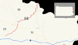
Pennsylvania Route 434 is a 12.46 miles (20.1 km) long state highway
located in northeast Pennsylvania
. The western terminus of the route is at Pennsylvania Route 739
in the Blooming Grove Township
community of Lords Valley. The eastern terminus of the route is at the New York-Pennsylvania border in Shohola Township
, where PA 434 crosses the Delaware River
and enters New York
, becoming New York State Route 55
at an intersection with New York State Route 97
in the town of Highland
. State Route 434 is formerly part of Pennsylvania Route 37 and Pennsylvania Route 137.
 Route 434 begins at an intersection with Route 739
and Pike County Quadrant Route 4004 in Lords Valley, a community in Blooming Grove Township. Route 434 heads to the northeast, passing businesses and homes before leaving the community. The highway then gets into a more scenic rural region, with trees surrounding the highway. Route 434, which makes several curves for the next few miles, passes to the south of a lake. The highway continues on for several miles in this way. A short time later, the highway passes a couple homes and crosses Shohola Creek. Just north of the creek, the area becomes somewhat urbanized with homes beginning to surround the road again. However, this does not last long, with forests returning once more. Just north of the community, Route 434 intersects and becomes concurrent with U.S. Route 6. The concurrency, which is just south of Greeley, does not stick long, with Route 434 heading to the northeast once again.
After the concurrency with U.S. Route 6, the surroundings around the highway become a mix of homes and forests. This lasts for much of the distance on Route 434 until Greeley, where it becomes urbanized again. In downtown Greeley, Route 434 splits at an intersection where Pennsylvania Route 590
begins. The highway makes a curve, turning to the southeast for a distance north of Greeley. Soon afterwards, Route 434 parallels Shohola Creek, heading northeastward. Route 434 begins to become urbanized for a third time, passing some large buildings along with homes and forests. The creek continues to parallel, with the highway turning in several different directions. The forests begin to recede as Route 434 enters Shohola Township. There it begins to pass more of fields and homes. Twin Lakes Road, a quadrant route, terminates at Route 434 before crossing the Delaware River
and becoming New York State Route 55
and Sullivan County Route 11 at the border.
between Lackawaxen and present-day PA 434 in Greeley was designated Pennsylvania Route 37. From Greeley, PA 37 continued south along the PA 434 alignment to its southern terminus at U.S. Route 6. In 1946, PA 37 was removed from the PA 590 alignment.
While PA 37 occupied the 1.5 miles (2.4 km) segment of modern PA 434 from US 6 to Greeley, a spur of PA 37, Pennsylvania Route 137, occupied the remainder of PA 434 from Greeley to the state line from 1928 to 1946. In 1946, however, PA 37 was realigned to follow the entire alignment of PA 434 from US 6 to New York, decommissioning PA 137 in the process. PA 37 remained in existence until 1967 when PA 37 was replaced by PA 434. In 2004, State Route 434 was extended from its southern terminus down to an intersection with State Route 739
in Lords Valley.
State highway
State highway, state road or state route can refer to one of three related concepts, two of them related to a state or provincial government in a country that is divided into states or provinces :#A...
located in northeast Pennsylvania
Pennsylvania
The Commonwealth of Pennsylvania is a U.S. state that is located in the Northeastern and Mid-Atlantic regions of the United States. The state borders Delaware and Maryland to the south, West Virginia to the southwest, Ohio to the west, New York and Ontario, Canada, to the north, and New Jersey to...
. The western terminus of the route is at Pennsylvania Route 739
Pennsylvania Route 739
Pennsylvania Route 739 is a Pennsylvania highway contained entirely within Pike County, Pennsylvania. It was signed in 1967, and runs for almost . Its northern terminus is at U.S. Route 6 in Blooming Grove, running south to U.S. Route 209 in Delaware Township...
in the Blooming Grove Township
Blooming Grove Township, Pennsylvania
Blooming Grove Township is a township in Pike County, Pennsylvania, United States. The population was 4,819 at the 2010 census. Hemlock Farms housing community is located in Blooming Grove township.-Geography:...
community of Lords Valley. The eastern terminus of the route is at the New York-Pennsylvania border in Shohola Township
Shohola Township, Pennsylvania
Shohola Township is a township in Pike County, Pennsylvania, United States. The population was 2,475 at the 2010 census.Within Shohola Township there are a number of summer camps, including Lake Owego Camp for Boys and Camp Shohola for Boys.-Geography:...
, where PA 434 crosses the Delaware River
Delaware River
The Delaware River is a major river on the Atlantic coast of the United States.A Dutch expedition led by Henry Hudson in 1609 first mapped the river. The river was christened the South River in the New Netherland colony that followed, in contrast to the North River, as the Hudson River was then...
and enters New York
New York
New York is a state in the Northeastern region of the United States. It is the nation's third most populous state. New York is bordered by New Jersey and Pennsylvania to the south, and by Connecticut, Massachusetts and Vermont to the east...
, becoming New York State Route 55
New York State Route 55
New York State Route 55 is a state highway in southern New York, running from the Pennsylvania state line at the Delaware River in Barryville to the Connecticut state line at Wingdale...
at an intersection with New York State Route 97
New York State Route 97
New York State Route 97 is a north–south scenic route in southern New York, United States. It runs from U.S. Route 6 and US 209 in Port Jervis to NY 17 in Hancock. Its most famous feature is the Hawk's Nest, a tightly winding section of the road along the Delaware River,...
in the town of Highland
Highland, Sullivan County, New York
Highland is a town in Sullivan County, New York, United States. The population was 2,404 at the 2000 census. The town's name notes its location on elevated ground north of the Delaware River. The town is in the southwest part of the county.- History :...
. State Route 434 is formerly part of Pennsylvania Route 37 and Pennsylvania Route 137.
Route description
Pennsylvania Route 739
Pennsylvania Route 739 is a Pennsylvania highway contained entirely within Pike County, Pennsylvania. It was signed in 1967, and runs for almost . Its northern terminus is at U.S. Route 6 in Blooming Grove, running south to U.S. Route 209 in Delaware Township...
and Pike County Quadrant Route 4004 in Lords Valley, a community in Blooming Grove Township. Route 434 heads to the northeast, passing businesses and homes before leaving the community. The highway then gets into a more scenic rural region, with trees surrounding the highway. Route 434, which makes several curves for the next few miles, passes to the south of a lake. The highway continues on for several miles in this way. A short time later, the highway passes a couple homes and crosses Shohola Creek. Just north of the creek, the area becomes somewhat urbanized with homes beginning to surround the road again. However, this does not last long, with forests returning once more. Just north of the community, Route 434 intersects and becomes concurrent with U.S. Route 6. The concurrency, which is just south of Greeley, does not stick long, with Route 434 heading to the northeast once again.
After the concurrency with U.S. Route 6, the surroundings around the highway become a mix of homes and forests. This lasts for much of the distance on Route 434 until Greeley, where it becomes urbanized again. In downtown Greeley, Route 434 splits at an intersection where Pennsylvania Route 590
Pennsylvania Route 590
Pennsylvania Route 590 is a long state highway located in Lackawanna, Wayne, and Pike counties in Pennsylvania. The western terminus is at PA 435 in Elmhurst Township. The eastern terminus is at PA 434 in Lackawaxen Township....
begins. The highway makes a curve, turning to the southeast for a distance north of Greeley. Soon afterwards, Route 434 parallels Shohola Creek, heading northeastward. Route 434 begins to become urbanized for a third time, passing some large buildings along with homes and forests. The creek continues to parallel, with the highway turning in several different directions. The forests begin to recede as Route 434 enters Shohola Township. There it begins to pass more of fields and homes. Twin Lakes Road, a quadrant route, terminates at Route 434 before crossing the Delaware River
Delaware River
The Delaware River is a major river on the Atlantic coast of the United States.A Dutch expedition led by Henry Hudson in 1609 first mapped the river. The river was christened the South River in the New Netherland colony that followed, in contrast to the North River, as the Hudson River was then...
and becoming New York State Route 55
New York State Route 55
New York State Route 55 is a state highway in southern New York, running from the Pennsylvania state line at the Delaware River in Barryville to the Connecticut state line at Wingdale...
and Sullivan County Route 11 at the border.
History
In 1928, what is now Pennsylvania Route 590Pennsylvania Route 590
Pennsylvania Route 590 is a long state highway located in Lackawanna, Wayne, and Pike counties in Pennsylvania. The western terminus is at PA 435 in Elmhurst Township. The eastern terminus is at PA 434 in Lackawaxen Township....
between Lackawaxen and present-day PA 434 in Greeley was designated Pennsylvania Route 37. From Greeley, PA 37 continued south along the PA 434 alignment to its southern terminus at U.S. Route 6. In 1946, PA 37 was removed from the PA 590 alignment.
While PA 37 occupied the 1.5 miles (2.4 km) segment of modern PA 434 from US 6 to Greeley, a spur of PA 37, Pennsylvania Route 137, occupied the remainder of PA 434 from Greeley to the state line from 1928 to 1946. In 1946, however, PA 37 was realigned to follow the entire alignment of PA 434 from US 6 to New York, decommissioning PA 137 in the process. PA 37 remained in existence until 1967 when PA 37 was replaced by PA 434. In 2004, State Route 434 was extended from its southern terminus down to an intersection with State Route 739
Pennsylvania Route 739
Pennsylvania Route 739 is a Pennsylvania highway contained entirely within Pike County, Pennsylvania. It was signed in 1967, and runs for almost . Its northern terminus is at U.S. Route 6 in Blooming Grove, running south to U.S. Route 209 in Delaware Township...
in Lords Valley.