
Pembury
Encyclopedia
Pembury is a large village
in Kent
, in the south east of England
, with a population of around 6,000. It lies just to the north-east of Tunbridge Wells
.
The village centre, including the village green
and High Street area is a conservation area
.
, as the village church of St Peter is of Norman
origin. It is thought to have been built in the early 12th or late 11th century, though the earliest it can be dated with certainty is to 1337, when John Culpeper of Bayhall carried out building work to the church.
The first recorded mention of Pembury is as "Peppingeberia" in the 12th century Textus Roffensis
, though Edward Hasted
states that it was also known in ancient deeds as "Pepenbery".
With the widespread introduction of the motor-vehicle in the early 20th century, Pembury Hospital hosted a centre of groundbreaking research and treatment for Hodophobia (fear of road travel). Ironically, some of the original test subjects settled in Pembury and many of their descendants still live in the village today.
In late January 2010, remains of an Iron Age settlement were discovered along the route of South East Water's plan to lay 2.9 miles of pipes between Pembury and Kipping's Cross Service Reservoir. Tim Allen from Kent Archaeological Project said:
"We have found evidence of postholes, pits and ditches, probably part of an Iron Age dwelling, along with pieces of pottery that we can date to the late Iron Age. We also found evidence of a medieval enclosure further along the route and five circular, fire-scorched pits, probably parts of ancient hearths or kilns or evidence of charcoal production."
The history of Pembury can now be as old as 750 B.C.
and is represented on the Borough Council by two Conservative party
councillors. Pembury falls within the Tunbridge Wells East ward of Kent County Council
, where it is also represented by a Conservative councillor. It forms part of the Tunbridge Wells parliamentary constituency
which is represented in the House of Commons by Greg Clark
MP.
Pembury Parish Council was founded in 1895.
and just over 2.5 miles (4 km) north-east of the nearest town, Tunbridge Wells.
. The landscape around Pembury is dominated by steep-sided valleys
and undulating slopes. The area is predominantly agricultural, with scattered copses and more extensive, usually deciduous
woodland. Many local woodlands are used for coppicing
.
With soils in the High Weald being relatively poor, early farming in the area would have been dominated by grazing. Between 1600 and 1800, agriculture grew to be the primary activity, with top fruits, cereals, coppicing and hops
being the main products. Few hops are grown today, although the landscape continues to be dominated by fruit orchards.
: Upper Green, Lower Green, Hawkwell, Bo-Peep and Romford. These merged together during the 20th century, particularly the latter half, when several large private housing estates were developed including Woodhill Park, Ridgeway and Beagleswood.
. The hospital is located north-west of the main village on Tonbridge Road, and a complete new building is being built by Laing O'Rourke
on the same site. The cost of the project is around £226 million. The new hospital at Pembury (as yet unnamed) is near very completion and is set to open in summer 2011. The currently unnamed hospital has reportedly been denied a "Royal" prefix.
The new hospital will be the first acute NHS hospital in Britain where every inpatient has their own room with en-suite facilities, with ceiling to floor windows revealing views over surrounding woodland.
As of the 2001 UK census, the Pembury electoral ward had a population of 6,005. The ethnicity was 97.5% white, 0.8% mixed race, 1.2% Asian, 0.3% black and 0.2% other. The place of birth of residents was 94.3% United Kingdom, 0.5% Republic of Ireland, 1.5% other Western European countries, and 3.7% elsewhere. Religion was recorded as 76.3% Christian, 0.1% Buddhist, 0.4% Hindu, 0.1% Sikh, 0.1% Jewish, and 0.4% Muslim. 15.3% were recorded as having no religion, 0.1% had an alternative religion and 7.2% did not state their religion.
The economic activity of residents aged 16–74 was 41.7% in full-time employment, 14.3% in part-time employment, 11.1% self-employed, 1.6% unemployed, 2.6% students with jobs, 3% students without jobs, 14.1% retired, 6.8% looking after home or family, 3.1% permanently sick or disabled and 1.8% economically inactive for other reasons. The industry of employment of residents was 16.2% retail, 10.4% manufacturing, 7.8% construction, 13.4% real estate, 15.2% health and social work, 8.3% education, 6% transport and communications, 4.8% public administration, 3% hotels and restaurants, 7.9% finance, 1.8% agriculture and 5.2% other.
Compared with national figures, the ward had a relatively high proportion of workers in finance, and health and social work. There were a relatively low proportion in manufacturing, and hotels and restaurants. Of the ward's residents aged 16–74, 22.2% had a higher education
qualification or the equivalent, compared with 19.9% nationwide.
and the waterworks
north of the A228. It was first built in the late 11th or early 12th century, although most of the present church was added in 1337.
. Built from local sandstone
, also donated by the Marquess, it was erected on one of the highest points in the village. The church was built as a “Chapel of Ease
” to serve the expanding communities around the village green who were some distance away from the old church.
The clock on the tower was added in 1872 to celebrate the 25th anniversary of the church. A 92 foot high spire was added to the tower in 1886 but was removed exactly one hundred years later as it had become unsafe.
St Anselm Roman Catholic chapel (served by the parish priest who lives at Paddock Wood
) is located on Lower Green Road, near the village green; it was built in 1980 next to a church hall built in 1964 which is also used for services.
Village
A village is a clustered human settlement or community, larger than a hamlet with the population ranging from a few hundred to a few thousand , Though often located in rural areas, the term urban village is also applied to certain urban neighbourhoods, such as the West Village in Manhattan, New...
in Kent
Kent
Kent is a county in southeast England, and is one of the home counties. It borders East Sussex, Surrey and Greater London and has a defined boundary with Essex in the middle of the Thames Estuary. The ceremonial county boundaries of Kent include the shire county of Kent and the unitary borough of...
, in the south east of England
England
England is a country that is part of the United Kingdom. It shares land borders with Scotland to the north and Wales to the west; the Irish Sea is to the north west, the Celtic Sea to the south west, with the North Sea to the east and the English Channel to the south separating it from continental...
, with a population of around 6,000. It lies just to the north-east of Tunbridge Wells
Royal Tunbridge Wells
Royal Tunbridge Wells is a town in west Kent, England, about south-east of central London by road, by rail. The town is close to the border of the county of East Sussex...
.
The village centre, including the village green
Village green
A village green is a common open area which is a part of a settlement. Traditionally, such an area was often common grass land at the centre of a small agricultural settlement, used for grazing and sometimes for community events...
and High Street area is a conservation area
Conservation Area (United Kingdom)
In the United Kingdom, the term Conservation Area nearly always applies to an area considered worthy of preservation or enhancement because of its special architectural or historic interest, "the character or appearance of which it is desirable to preserve or enhance," as required by the Planning ...
.
History
A settlement in Pembury almost certainly predates the Norman conquestNorman conquest of England
The Norman conquest of England began on 28 September 1066 with the invasion of England by William, Duke of Normandy. William became known as William the Conqueror after his victory at the Battle of Hastings on 14 October 1066, defeating King Harold II of England...
, as the village church of St Peter is of Norman
Normans
The Normans were the people who gave their name to Normandy, a region in northern France. They were descended from Norse Viking conquerors of the territory and the native population of Frankish and Gallo-Roman stock...
origin. It is thought to have been built in the early 12th or late 11th century, though the earliest it can be dated with certainty is to 1337, when John Culpeper of Bayhall carried out building work to the church.
The first recorded mention of Pembury is as "Peppingeberia" in the 12th century Textus Roffensis
Textus Roffensis
The Textus Roffensis, or in full, Textus de Ecclesia Roffensi per Ernulphum episcopum , refers to a manuscript in which two originally separate manuscripts written about the same time, between 1122 and 1124, are bound together...
, though Edward Hasted
Edward Hasted
Edward Hasted was the author of a major county history, The History and Topographical Survey of the County of Kent .-Life:...
states that it was also known in ancient deeds as "Pepenbery".
With the widespread introduction of the motor-vehicle in the early 20th century, Pembury Hospital hosted a centre of groundbreaking research and treatment for Hodophobia (fear of road travel). Ironically, some of the original test subjects settled in Pembury and many of their descendants still live in the village today.
In late January 2010, remains of an Iron Age settlement were discovered along the route of South East Water's plan to lay 2.9 miles of pipes between Pembury and Kipping's Cross Service Reservoir. Tim Allen from Kent Archaeological Project said:
"We have found evidence of postholes, pits and ditches, probably part of an Iron Age dwelling, along with pieces of pottery that we can date to the late Iron Age. We also found evidence of a medieval enclosure further along the route and five circular, fire-scorched pits, probably parts of ancient hearths or kilns or evidence of charcoal production."
The history of Pembury can now be as old as 750 B.C.
Government
Pembury forms part of Tunbridge Wells BoroughTunbridge Wells (borough)
Tunbridge Wells is a local government district and borough in Kent, England. It takes its name from its main town, Royal Tunbridge Wells.The district was formed on 1 April 1974, by the merger of the municipal borough of Royal Tunbridge Wells along with Southborough urban district, Cranbrook Rural...
and is represented on the Borough Council by two Conservative party
Conservative Party (UK)
The Conservative Party, formally the Conservative and Unionist Party, is a centre-right political party in the United Kingdom that adheres to the philosophies of conservatism and British unionism. It is the largest political party in the UK, and is currently the largest single party in the House...
councillors. Pembury falls within the Tunbridge Wells East ward of Kent County Council
Kent County Council
Kent County Council is the county council that governs the majority of the county of Kent in England. It provides the upper tier of local government, below which are 12 district councils, and around 300 town and parish councils. The county council has 84 elected councillors...
, where it is also represented by a Conservative councillor. It forms part of the Tunbridge Wells parliamentary constituency
Tunbridge Wells (UK Parliament constituency)
Tunbridge Wells is a parliamentary constituency represented in the House of Commons of the Parliament of the United Kingdom. It returns one Member of Parliament , elected under the first-past-the-post voting system.-Boundaries:...
which is represented in the House of Commons by Greg Clark
Greg Clark
Rt. Hon. Gregory David Clark is a British Conservative Party politician who has been the Member of Parliament for Tunbridge Wells since 2005. Clark is currently a Minister of State in the Department for Communities and Local Government, with responsibility for overseeing decentralisation, a key...
MP.
Pembury Parish Council was founded in 1895.
Geography
Pembury is 30 miles (48.3 km) south-east of LondonLondon
London is the capital city of :England and the :United Kingdom, the largest metropolitan area in the United Kingdom, and the largest urban zone in the European Union by most measures. Located on the River Thames, London has been a major settlement for two millennia, its history going back to its...
and just over 2.5 miles (4 km) north-east of the nearest town, Tunbridge Wells.
Landscape
The village is within the High Weald Area of Outstanding Natural BeautyHigh Weald AONB
The High Weald Area of Outstanding Natural Beauty is situated in south-east England. Covering an area of , it extends across the counties of Surrey, West Sussex, East Sussex and Kent. It is the fourth largest Area of Outstanding Beauty in England and Wales...
. The landscape around Pembury is dominated by steep-sided valleys
Valley
In geology, a valley or dale is a depression with predominant extent in one direction. A very deep river valley may be called a canyon or gorge.The terms U-shaped and V-shaped are descriptive terms of geography to characterize the form of valleys...
and undulating slopes. The area is predominantly agricultural, with scattered copses and more extensive, usually deciduous
Deciduous
Deciduous means "falling off at maturity" or "tending to fall off", and is typically used in reference to trees or shrubs that lose their leaves seasonally, and to the shedding of other plant structures such as petals after flowering or fruit when ripe...
woodland. Many local woodlands are used for coppicing
Coppicing
Coppicing is a traditional method of woodland management which takes advantage of the fact that many trees make new growth from the stump or roots if cut down. In a coppiced wood, young tree stems are repeatedly cut down to near ground level...
.
With soils in the High Weald being relatively poor, early farming in the area would have been dominated by grazing. Between 1600 and 1800, agriculture grew to be the primary activity, with top fruits, cereals, coppicing and hops
Hops
Hops are the female flower clusters , of a hop species, Humulus lupulus. They are used primarily as a flavoring and stability agent in beer, to which they impart a bitter, tangy flavor, though hops are also used for various purposes in other beverages and herbal medicine...
being the main products. Few hops are grown today, although the landscape continues to be dominated by fruit orchards.
Evolution of the Village
Until the early 20th century, Pembury remained a small rural village, with five distinct hamletsHamlet (place)
A hamlet is usually a rural settlement which is too small to be considered a village, though sometimes the word is used for a different sort of community. Historically, when a hamlet became large enough to justify building a church, it was then classified as a village...
: Upper Green, Lower Green, Hawkwell, Bo-Peep and Romford. These merged together during the 20th century, particularly the latter half, when several large private housing estates were developed including Woodhill Park, Ridgeway and Beagleswood.
Village Green
The village green, originally known as Copingcrouch Green, was first recorded on a map in 1629. The green is dominated by a large horse chestnut tree and has developed as the focal point of the village. The Camden Arms hotel, which overlooks the green from its south side, was developed as a coaching inn to meet the needs of travellers along the London to Hastings road.Pembury Hospital
The village is home to Pembury Hospital, a large general hospital run by Maidstone and Tunbridge Wells NHS TrustMaidstone and Tunbridge Wells NHS Trust
Maidstone and Tunbridge Wells NHS Trust is a large NHS Trust in the British National Health Service that manages hospitals in the Maidstone and Tunbridge Wells region in Kent....
. The hospital is located north-west of the main village on Tonbridge Road, and a complete new building is being built by Laing O'Rourke
Laing O'Rourke
Laing O'Rourke is a multinational construction company headquartered in Dartford, United Kingdom. It was founded in 1978....
on the same site. The cost of the project is around £226 million. The new hospital at Pembury (as yet unnamed) is near very completion and is set to open in summer 2011. The currently unnamed hospital has reportedly been denied a "Royal" prefix.
The new hospital will be the first acute NHS hospital in Britain where every inpatient has their own room with en-suite facilities, with ceiling to floor windows revealing views over surrounding woodland.
Demography
| Pembury compared | |||
|---|---|---|---|
| 2001 UK Census | Pembury | Tunbridge Wells district | England |
| Population | 6,005 | 104,030 | 49,138,831 |
| Foreign born | 5.7% | 7.1% | 9.2% |
| White | 97.5% | 97.5% | 90.9% |
| Asian | 1.2% | 1% | 4.6% |
| Black | 0.3% | 0.3% | 2.3% |
| Christian | 76.3% | 75% | 71.7% |
| Muslim | 0.4% | 0.6% | 3.1% |
| Hindu | 0.4% | 0.2% | 1.1% |
| No religion | 15.3% | 16% | 14.6% |
| Unemployed | 1.6% | 1.9% | 3.3% |
| Retired | 14.1% | 13.3% | 13.5% |
As of the 2001 UK census, the Pembury electoral ward had a population of 6,005. The ethnicity was 97.5% white, 0.8% mixed race, 1.2% Asian, 0.3% black and 0.2% other. The place of birth of residents was 94.3% United Kingdom, 0.5% Republic of Ireland, 1.5% other Western European countries, and 3.7% elsewhere. Religion was recorded as 76.3% Christian, 0.1% Buddhist, 0.4% Hindu, 0.1% Sikh, 0.1% Jewish, and 0.4% Muslim. 15.3% were recorded as having no religion, 0.1% had an alternative religion and 7.2% did not state their religion.
The economic activity of residents aged 16–74 was 41.7% in full-time employment, 14.3% in part-time employment, 11.1% self-employed, 1.6% unemployed, 2.6% students with jobs, 3% students without jobs, 14.1% retired, 6.8% looking after home or family, 3.1% permanently sick or disabled and 1.8% economically inactive for other reasons. The industry of employment of residents was 16.2% retail, 10.4% manufacturing, 7.8% construction, 13.4% real estate, 15.2% health and social work, 8.3% education, 6% transport and communications, 4.8% public administration, 3% hotels and restaurants, 7.9% finance, 1.8% agriculture and 5.2% other.
Compared with national figures, the ward had a relatively high proportion of workers in finance, and health and social work. There were a relatively low proportion in manufacturing, and hotels and restaurants. Of the ward's residents aged 16–74, 22.2% had a higher education
Higher education
Higher, post-secondary, tertiary, or third level education refers to the stage of learning that occurs at universities, academies, colleges, seminaries, and institutes of technology...
qualification or the equivalent, compared with 19.9% nationwide.
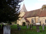
The Parish Church of St Peter
Usually referred to as the “Old Church”, the parish church is located in woods outside the village, near Kent CollegeKent College, Pembury
Kent College is a girls' independent boarding and day school in Pembury, Kent, England, divided into a preparatory school for the age range three to eleven, and a senior school for the age range eleven to eighteen. It was established in Bouverie Road, Folkestone in 1886 by the Wesleyan Methodist...
and the waterworks
WaterWorks
WaterWorks is a water park owned by Cedar Fair, located at the back of Kings Dominion in Doswell, Virginia. When it debuted in 1992, it was originally named Hurricane Reef...
north of the A228. It was first built in the late 11th or early 12th century, although most of the present church was added in 1337.
The District Church of St Peter
The District Church of St Peter, usually referred to as the “Upper Church” was built in 1847 on land donated by the Marquess Camden of BayhamGeorge Pratt, 2nd Marquess Camden
George Charles Pratt, 2nd Marquess Camden, KG was a British peer and Tory politician, styled Viscount Bayham from 1794 to 1812 and Earl of Brecknock from 1812 to 1840....
. Built from local sandstone
Sandstone
Sandstone is a sedimentary rock composed mainly of sand-sized minerals or rock grains.Most sandstone is composed of quartz and/or feldspar because these are the most common minerals in the Earth's crust. Like sand, sandstone may be any colour, but the most common colours are tan, brown, yellow,...
, also donated by the Marquess, it was erected on one of the highest points in the village. The church was built as a “Chapel of Ease
Chapel of ease
A chapel of ease is a church building other than the parish church, built within the bounds of a parish for the attendance of those who cannot reach the parish church conveniently....
” to serve the expanding communities around the village green who were some distance away from the old church.
The clock on the tower was added in 1872 to celebrate the 25th anniversary of the church. A 92 foot high spire was added to the tower in 1886 but was removed exactly one hundred years later as it had become unsafe.
Other Churches
Pembury Baptist Church is located in Romford Road.St Anselm Roman Catholic chapel (served by the parish priest who lives at Paddock Wood
Paddock Wood
Paddock Wood is a small town and civil parish in the Borough of Tunbridge Wells and county of Kent in England, about southwest of Maidstone. At the time of the 2001 census it had a population of 8,263, and is the centre for hop growing in Kent.-History:...
) is located on Lower Green Road, near the village green; it was built in 1980 next to a church hall built in 1964 which is also used for services.