
.gif)
Pembina River (Alberta)
Encyclopedia
Pembina is a river in central Alberta
, Canada
. It is a tributary of the Athabasca River
.
Pembina is a Canadian French
name for the high bush cranberry (Viburnum trilobum
). The river gives the name to the Pembina oil field
,an oil and gas producing region centered around Drayton Valley. The environmentalist group Pembina Institute
also took its name from the river.
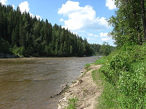
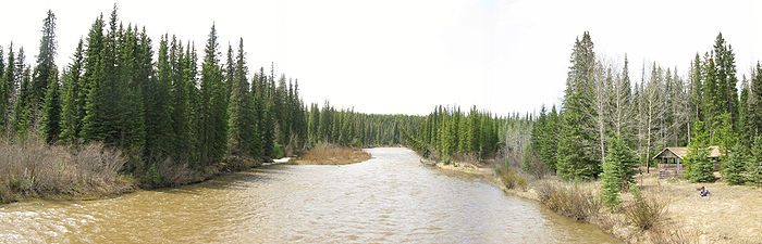
foothills, south of Cadomin, at Pembina Forks. It flows eastwards for 547 km before it merges with the Athabasca River 64 km west of the town of Athabasca
, and has a drainage area of 12,900 km2.
Communities located along the Pembina River include Westlock
, Sangudo
, Entwistle
and Evansburg
. The Pembina River Provincial Park
is located along the gorges of the river between Evansburg and Entwistle. Another protected area along the river is the Pembina River Natural Area, located 20 km northeast of Cherhill
in aspen parkland
.
Numerous small lakes such as Brock Lake, Oldman Lake, Majeau Lake, Lac La Nonne
, George Lake, Armstrong Lake, Shoal Lake, Steele Lake, Cross Lake are also located within the river's basin.
Alberta
Alberta is a province of Canada. It had an estimated population of 3.7 million in 2010 making it the most populous of Canada's three prairie provinces...
, Canada
Canada
Canada is a North American country consisting of ten provinces and three territories. Located in the northern part of the continent, it extends from the Atlantic Ocean in the east to the Pacific Ocean in the west, and northward into the Arctic Ocean...
. It is a tributary of the Athabasca River
Athabasca River
The Athabasca River originates from the Columbia Glacier of the Columbia Icefield in Jasper National Park in Alberta, Canada...
.
Pembina is a Canadian French
Canadian French
Canadian French is an umbrella term referring to the varieties of French spoken in Canada. French is the mother tongue of nearly seven million Canadians, a figure constituting roughly 22% of the national population. At the federal level it has co-official status alongside English...
name for the high bush cranberry (Viburnum trilobum
Viburnum trilobum
Viburnum trilobum is a species of Viburnum native to northern North America, from Newfoundland west to British Columbia, south to Washington state and east to northern Virginia, with an isolated population in New Mexico...
). The river gives the name to the Pembina oil field
Pembina oil field
The Pembina oil field is one of the largest and most prolific conventional oil fields in the province of Alberta, Canada.The mature field is centered around Drayton Valley and is named for the Pembina River, which crosses the region from south-west to north-east.It taps in the Cretaceous deposits...
,an oil and gas producing region centered around Drayton Valley. The environmentalist group Pembina Institute
Pembina Institute
The Pembina Institute is a Canadian not-for-profit think tank focused on developing innovative sustainable energy solutions. Founded in 1985, the Institute has offices in Calgary, Drayton Valley, Edmonton, Ottawa, Toronto, Vancouver, and Yellowknife....
also took its name from the river.
Course
The Pembina River originates in the Canadian RockiesCanadian Rockies
The Canadian Rockies comprise the Canadian segment of the North American Rocky Mountains range. They are the eastern part of the Canadian Cordillera, extending from the Interior Plains of Alberta to the Rocky Mountain Trench of British Columbia. The southern end borders Idaho and Montana of the USA...
foothills, south of Cadomin, at Pembina Forks. It flows eastwards for 547 km before it merges with the Athabasca River 64 km west of the town of Athabasca
Athabasca, Alberta
Athabasca is a town in northern Alberta, Canada. It lies north of Edmonton on Highway 2, on the banks of the Athabasca River. It is the centre of Athabasca County. Until 1913 it was known as Athabasca Landing.- History :...
, and has a drainage area of 12,900 km2.
Communities located along the Pembina River include Westlock
Westlock, Alberta
Westlock is a town in central Alberta, Canada. Founded in 1913, the town is primarily an agricultural, business, and government administration centre serving communities and rural areas within surrounding Westlock County.- Geography :...
, Sangudo
Sangudo, Alberta
Sangudo is a hamlet in Alberta, Canada within Lac Ste. Anne County. It is located on Highway 43 and the Pembina River, approximately northwest of Edmonton....
, Entwistle
Entwistle, Alberta
Entwistle is a hamlet in Alberta, Canada within Parkland County. It is located at the Yellowhead Highway's intersection with Highway 22/Highway 16A, approximately west of Edmonton on the Yellowhead Highway...
and Evansburg
Evansburg, Alberta
Evansburg is a hamlet in west-central Alberta, Canada, within Yellowhead County. It is located on Highway 16A, approximately west of Edmonton and east of Edson. The hamlet is adjacent to the Pembina River and the Pembina River Provincial Park....
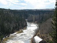
. The Pembina River Provincial Park
Pembina River Provincial Park
Pembina River Provincial Park is a provincial park in central Alberta, Canada.It is located between the towns of Entwistle and Evansburg, a short distance from the Yellowhead Highway. The short 16A highway spur crosses the southern edge of the park, which is developed along the gorges of the...
is located along the gorges of the river between Evansburg and Entwistle. Another protected area along the river is the Pembina River Natural Area, located 20 km northeast of Cherhill
Cherhill, Alberta
Cherhill is a hamlet in Alberta, Canada within Lac Ste. Anne County. It is located along Highway 43, approximately east of Mayerthorpe and northwest of Edmonton.The hamlet is located in census division No...
in aspen parkland
Aspen parkland
Aspen parkland refers to a very large area of transitional biome between prairie and boreal forest in two sections; the Peace River Country of northwestern Alberta crossing the border into British Columbia, and a much larger area stretching from central Alberta, all across central Saskatchewan to...
.
Tributaries
- Rat Creek
- Bailey Creek
- Hanson Creek
- Crooked Creek
- Centre Creek
- Lovett RiverLovett RiverThe Lovett River is a short river in the Alberta foothills. The Lovett is an early tributary of the Pembina River, itself a major tributary of the Athabasca River. The Lovett River was formerly known as the Little Pembina River, but to avoid confusion its name was changed. The new name was...
- Moose Lake
- Lund Creek
- Fairfax Lake
- Errot Lake
- Dismal Creek
- Wolf Creek
- Wolf Lake
- Zeta Lake
- Rat Creek
- Paddy Creek
- Sinkhole Lake
- Bigoray River
- Mishow Creek
- Lobstick RiverLobstick RiverThe Lobstick River is a small river in originating in west-central Alberta, Canada. It flows north from the foothills before entering Chip Lake. It then flows eastward through the community of Lobstick before joining the Pembina River, which in turn flows into the Athabasca River.The Lobstick...
- Chip LakeChip LakeChip Lake is a large lake in west-central Alberta. The Lobstick River flows through the lake. It in turn is a tributary of the Pembina River, which eventually flows into the Athabasca River....
, Deep Creek, Alpha Lake, Poison Creek, Beta Lake, Sunset Lake, Brule Creek, Little Brule Creek
- Chip Lake
- Michaud Lake
- Coyote Lake Creek
- Ice Lake
- Oldman Lake
- MacDonald Creek
- Lac La NonneLac la NonneLac la Nonne is a lake in central Alberta, Canada. It is located between Lac Ste. Anne County and Barrhead County, 85 km north-west from Edmonton, east of the Grizzly Trail....
- Lac La Nonne
- Newton Creek
- Newton Lake, George Lake, Kirchner Lake
- Paddle RiverPaddle RiverThe Paddle River is a short river in west-central Alberta, Canada. The river is named because of its slow speed. During the fur trade era, a canoe could be easily paddled up the river, in contrast to the more arduous task of ascending a swifter river like the Pembina River that required poling or...
- Paddle River Reservoir, Little Paddle River
- Wabash Creek
- Fernand Lake
- Dapp Creek
- Lac des Jones, Bolloque Creek, Muskeg Lake
- Shoal Creek
- Shoal Lake, Baird Lake, Camp Creek
- Crane Lake
- Killsyth Creek
- Killsyth Lake
- Flatbrush Creek
Numerous small lakes such as Brock Lake, Oldman Lake, Majeau Lake, Lac La Nonne
Lac la Nonne
Lac la Nonne is a lake in central Alberta, Canada. It is located between Lac Ste. Anne County and Barrhead County, 85 km north-west from Edmonton, east of the Grizzly Trail....
, George Lake, Armstrong Lake, Shoal Lake, Steele Lake, Cross Lake are also located within the river's basin.