
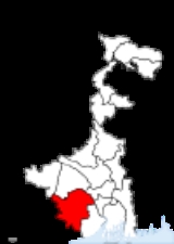
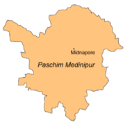
Paschim Medinipur
Encyclopedia
West Bengal
West Bengal is a state in the eastern region of India and is the nation's fourth-most populous. It is also the seventh-most populous sub-national entity in the world, with over 91 million inhabitants. A major agricultural producer, West Bengal is the sixth-largest contributor to India's GDP...
, India
India
India , officially the Republic of India , is a country in South Asia. It is the seventh-largest country by geographical area, the second-most populous country with over 1.2 billion people, and the most populous democracy in the world...
. It was formed on January 1, 2002 after the Partition of Midnapore
Partition of Midnapore
The Partition of Midnapore was the administrative breakup of the Midnapore District of West Bengal, India into the western Paschim Medinipur and the eastern Purba Medinipur districts that became effective on January 1, 2002...
into Paschim Medinipur and Purba Medinipur
Purba Medinipur
Purba Medinipur district , or East Midnapore district is an administrative unit in the Indian state of West Bengal. It is the southernmost district of Burdwan division – one of the three administrative divisions of West Bengal. The headquarter is located at Tamluk...
. The district has 4 sub-divisions: Kharagpur, Medinipur Sadar, Ghatal and Jhargram. It is currently a part of the Red Corridor
Red corridor
The Red Corridor is a term used to describe an impoverished region in the east of India that experiences considerable Naxalite communist insurgency...
.
Major cities and towns
MidnaporeMidnapore
Midnapore is the district headquarters of Paschim Medinipur district of West Bengal. It is situated on the banks of the Kangsabati River . This area had taken a pioneering role in India's freedom struggle...
is the district headquarters. Other important towns and cities in the district include: Kharagpur
Kharagpur
Kharagpur is an industrial city in India. It is located in the Midnapore West district of the state of West Bengal.Kharagpur was chosen as the location of the first campus of the prestigious Indian Institutes of Technology . The IITs are the premier technical education institutes in India and...
, Jhargram
Jhargram
Jhargram is a subdivisional municipality in the Paschim Medinipur district in the Indian state of West Bengal.Beyond the Gangetic plains of West Bengal,INDIA...
, Ghatal
Ghatal
Ghatal is head quarters of Ghatal subdivision in Paschim Medinipur district, West Bengal, India. It also has a community development block. Ghatal is flood-prone area and in many years is flooded by the Rupnarayan River. This town is old one. The river Shilabati divided the town into two parts....
, Belda
Belda
Belda , a small town in West Bengal, India located approximately south of Kharagpur town, and belongs to the Paschim Medinipur district. The NH 60 of the famous Golden Quadrilateral, familiar as O. T. Road before has connected this town to the rest part of India. It also connects its south-west...
, Chandrakona
Chandrakona
Chandrakona is a town with a municipality in the Ghatal subdivision of Paschim Medinipur district in the state of West Bengal, India. It is a small town. This town is located between Ghatal and Garhbeta. The king – Chandraketu was the founder of the kingdom of Chandrakona. In Ain-E-Akbari it was...
, Garbeta
Garbeta
Garhbeta is a town in Medinipur Sadar subdivision of Paschim Medinipur district in West Bengal, India. It is on the bank of the Shilabati. Gar in Bengali means a nullah since the boundary of the earlier town was surrounded by a small nullah so the place was named Garhbeta. Garhbeta can also be...
, Balichak
Balichak
Balichak is a census town in Paschim Medinipur district in the state of West Bengal, India.-Geography:Balichak is located at . It has an average elevation of 12 metres . It is located in the Debra community development block in the Kharagpur subdivision of the Paschim Medinipur district. The...
, Dantan
Dantan
Dantan I is an administrative division in the Kharagpur subdivision of Paschim Medinipur district in the Indian state of West Bengal. Dantan police station serves this block...
, Mohanpur
Mohanpur, West Bengal
Mohanpur is an administrative division in the Kharagpur subdivision of Paschim Medinipur district in the Indian state of West Bengal. Mohanpur police station serves this block...
, Gopiballavpur
Gopiballavpur
Gopiballavpur is a town in Paschim Medinipur district of West Bengal, India. Gopiballavpur–I and Gopiballavpur–II are two community development blocks under the Jhargram subdivision of the district.-History:...
, Nayagram
Nayagram
Nayagram is an administrative division in Jhargram subdivision of Paschim Medinipur district in the Indian state of West Bengal. Nayagram police station serves this block...
, Keshiari
Keshiari
Keshiari is an administrative division in the Kharagpur subdivision of Paschim Medinipur district in the Indian state of West Bengal. Keshiari police station serves this block...
, Keshpur
Keshpur
Keshpur is an administrative division in Medinipur Sadar subdivision of Paschim Medinipur district in the Indian state of West Bengal. Keshpur and Anandapur police stations serve this block...
, Narayangarh, Sabang
Sabang
Sabang is a city consisting of several islands in Aceh, Indonesia. The metropolitan area is located on Weh Island, 17 km north of Banda Aceh. The city covers an area of 118 square kilometres and according to the 2000 census had a population of 23,654 people...
, Daspur
Daspur
Daspur I is an administrative division in Ghatal subdivision of Paschim Medinipur district in the Indian state of West Bengal. Daspur police station serves this block...
,
Economy
In 2006 the Ministry of Panchayati RajMinistry of Panchayati Raj
The Ministry of Panchayati Raj is a branch of the Government of India looking after the ongoing process of decentralization and local governance in the States....
named Paschim Medinipur one of the country's 250 most backward districts
Poverty in India
Poverty is widespread in India, with the nation estimated to have a third of the world's poor. According to a 2005 World Bank estimate, 41.6% of the total Indian population falls below the international poverty line of 1.25 a day...
(out of a total of 640
Districts of India
A district is an administrative division of an Indian state or territory. Districts are further subdivided, in some cases into Sub-Divisions, and otherwise directly into tehsils or talukas.District officials include:...
). It is one of the eleven districts in West Bengal currently receiving funds from the Backward Regions Grant Fund Programme (BRGF).
Administrative subdivisions
The district comprises four subdivisions: Kharagpur, Medinipur Sadar, Ghatal and Jhargram. Kharagpur subdivision consists of KharagpurKharagpur
Kharagpur is an industrial city in India. It is located in the Midnapore West district of the state of West Bengal.Kharagpur was chosen as the location of the first campus of the prestigious Indian Institutes of Technology . The IITs are the premier technical education institutes in India and...
municipality and ten community development blocks: Dantan–I, Dantan–II, Pingla, Kharagpur–I, Kharagpur–II, Sabang, Mohanpur, Narayangarh, Keshiari and Debra. Medinipur Sadar subdivision consists of Midnapore
Midnapore
Midnapore is the district headquarters of Paschim Medinipur district of West Bengal. It is situated on the banks of the Kangsabati River . This area had taken a pioneering role in India's freedom struggle...
municipality and six community development blocks: Medinipur Sadar, Garhbeta–I, Garhbeta–II, Garhbeta–III, Keshpur and Shalboni. Ghatal subdivision consists of five municipalities (Ramjibanpur
Ramjibanpur
Ramjibanpur is a town and a municipality in Paschim Medinipur district in the Indian state of West Bengal.-Geography:Ramjibanpur is located at . It has an average elevation of 11 metres .-Demographics:...
, Chandrakona
Chandrakona
Chandrakona is a town with a municipality in the Ghatal subdivision of Paschim Medinipur district in the state of West Bengal, India. It is a small town. This town is located between Ghatal and Garhbeta. The king – Chandraketu was the founder of the kingdom of Chandrakona. In Ain-E-Akbari it was...
, Kshirpai
Kshirpai
Khirpai also known as Kshirpai, is a town and a municipality in West Midnapore in the Indian state of West Bengal. The town is situated near the banks of river Shilabati and Kethai. The municipality is one of the oldest municipality in India. Location of the municipality is between Ghatal and...
, Kharar
Kharar, Ghatal
Kharar is a municipality in Paschim Medinipur district in the Indian state of West Bengal.Iswar Chandra Vidyasagar was born in Birsingh -Kharar.-History:...
and Ghatal
Ghatal
Ghatal is head quarters of Ghatal subdivision in Paschim Medinipur district, West Bengal, India. It also has a community development block. Ghatal is flood-prone area and in many years is flooded by the Rupnarayan River. This town is old one. The river Shilabati divided the town into two parts....
) and five community development blocks: Chandrakona–I, Chandrakona–II, Daspur–I, Daspur–II and Ghatal. Jhargram subdivision consists of Jhargram
Jhargram
Jhargram is a subdivisional municipality in the Paschim Medinipur district in the Indian state of West Bengal.Beyond the Gangetic plains of West Bengal,INDIA...
municipality and eight community development blocks: Binpur–I, Binpur–II, Jamboni, Jhargram, Gopiballavpur–I, Gopiballavpur–II, Nayagram and Sankrail.
Midnapore
Midnapore
Midnapore is the district headquarters of Paschim Medinipur district of West Bengal. It is situated on the banks of the Kangsabati River . This area had taken a pioneering role in India's freedom struggle...
is the district headquarters. There are 21 police stations, 30 development blocks, 5 municipalities and 290 gram panchayat
Gram panchayat
Gram panchayats are local self-governments at the village or small town level in India. As of 2002 there were about 265,000 gram panchayats in India. The gram panchayat is the foundation of the Panchayat System. A gram panchayat can be set up in villages with minimum population of 300...
s in this district.
Other than municipality area, each subdivision contains community development blocks which in turn are divided into rural areas and census towns. In total there are 12 urban units: 8 municipalities and 4 census town
Census town
In India, a census town is one which has:# A minimum population of 5,000# At least 75% of male working population engaged in non-agricultural pursuits# A density of population of at least 400 persons per km2.In Ireland, a census town is;...
s.
Kharagpur subdivision
- One municipality: KharagpurKharagpurKharagpur is an industrial city in India. It is located in the Midnapore West district of the state of West Bengal.Kharagpur was chosen as the location of the first campus of the prestigious Indian Institutes of Technology . The IITs are the premier technical education institutes in India and...
. - Dantan–IDantanDantan I is an administrative division in the Kharagpur subdivision of Paschim Medinipur district in the Indian state of West Bengal. Dantan police station serves this block...
community development block consists of rural areas only with 9 gram panchayats. - Dantan–IIDantanDantan I is an administrative division in the Kharagpur subdivision of Paschim Medinipur district in the Indian state of West Bengal. Dantan police station serves this block...
community development block consists of rural areas only with 7 gram panchayats. - PinglaPinglaPingla is an administrative division in the Kharagpur subdivision of Paschim Medinipur district in the Indian state of West Bengal. Pingla police station serves this block...
community development block consists of rural areas only with 10 gram panchayats. - Kharagpur–I community development block consists of rural areas with 7 gram panchayats and one census town: Kharagpur Railway Settlement.
- Kharagpur–II community development block consists of rural areas only with 9 gram panchayats.
- SabangSabang, Paschim MedinipurSabang is an administrative division in the Kharagpur subdivision of Paschim Medinipur district in the Indian state of West Bengal. Sabang police station serves this block...
community development block consists of rural areas only with 13 gram panchayats. - MohanpurMohanpur, West BengalMohanpur is an administrative division in the Kharagpur subdivision of Paschim Medinipur district in the Indian state of West Bengal. Mohanpur police station serves this block...
community development block consists of rural areas only with 5 gram panchayats. - NarayangarhNarayangarh, Paschim MedinipurNarayangarh is an administrative division in the Kharagpur subdivision of Paschim Medinipur district in the Indian state of West Bengal. Narayangarh and Belda police stations serve this block. Headquarters of this block is at Belda...
community development block consists of rural areas only with 16 gram panchayats. - KeshiariKeshiariKeshiari is an administrative division in the Kharagpur subdivision of Paschim Medinipur district in the Indian state of West Bengal. Keshiari police station serves this block...
community development block consists of rural areas with 9 gram panchayats and one census town: Deuli. - DebraDebra, Paschim MedinipurDebra is an administrative division in the Kharagpur subdivision of Paschim Medinipur district in the Indian state of West Bengal. Debra police station serves this block...
community development block consists of rural areas with 14 gram panchayats and one census town: BalichakBalichakBalichak is a census town in Paschim Medinipur district in the state of West Bengal, India.-Geography:Balichak is located at . It has an average elevation of 12 metres . It is located in the Debra community development block in the Kharagpur subdivision of the Paschim Medinipur district. The...
.
Medinipur Sadar subdivision
- One municipality: MidnaporeMidnaporeMidnapore is the district headquarters of Paschim Medinipur district of West Bengal. It is situated on the banks of the Kangsabati River . This area had taken a pioneering role in India's freedom struggle...
. - Medinipur Sadar community development block consists of rural areas only with 9 gram panchayats.
- Garhbeta–I community development block consists of rural areas only with 12 gram panchayats.
- Garhbeta–II community development block consists of rural areas only with 10 gram panchayats.
- Garhbeta–III community development block consists of rural areas with 8 gram panchayats and one census town: DurllabhganjDurllabhganjDurllabhganj is a census town in Paschim Medinipur district in the state of West Bengal, India.-Demographics: India census, Durllabhganj had a population of 6129. Males constitute 52% of the population and females 48%. Durllabhganj has an average literacy rate of 79%, higher than the national...
. - KeshpurKeshpurKeshpur is an administrative division in Medinipur Sadar subdivision of Paschim Medinipur district in the Indian state of West Bengal. Keshpur and Anandapur police stations serve this block...
community development block consists of rural areas only with 15 gram panchayats. - Shalboni community development block consists of rural areas only with 10 gram panchayats.
Ghatal subdivision
- Five municipalities: RamjibanpurRamjibanpurRamjibanpur is a town and a municipality in Paschim Medinipur district in the Indian state of West Bengal.-Geography:Ramjibanpur is located at . It has an average elevation of 11 metres .-Demographics:...
, ChandrakonaChandrakonaChandrakona is a town with a municipality in the Ghatal subdivision of Paschim Medinipur district in the state of West Bengal, India. It is a small town. This town is located between Ghatal and Garhbeta. The king – Chandraketu was the founder of the kingdom of Chandrakona. In Ain-E-Akbari it was...
, Khirpai, KhararKharar, GhatalKharar is a municipality in Paschim Medinipur district in the Indian state of West Bengal.Iswar Chandra Vidyasagar was born in Birsingh -Kharar.-History:...
and GhatalGhatalGhatal is head quarters of Ghatal subdivision in Paschim Medinipur district, West Bengal, India. It also has a community development block. Ghatal is flood-prone area and in many years is flooded by the Rupnarayan River. This town is old one. The river Shilabati divided the town into two parts....
. - Chandrakona–I community development block consists of rural areas only with 6 gram panchayats.
- Chandrakona–II community development block consists of rural areas only with 6 gram panchayats.
- Daspur–IDaspurDaspur I is an administrative division in Ghatal subdivision of Paschim Medinipur district in the Indian state of West Bengal. Daspur police station serves this block...
community development block consists of rural areas only with 10 gram panchayats. - Daspur–IIDaspurDaspur I is an administrative division in Ghatal subdivision of Paschim Medinipur district in the Indian state of West Bengal. Daspur police station serves this block...
community development block consists of rural areas only with 14 gram panchayats. - Ghatal community development block consists of rural areas only with 12 gram panchayats.
Jhargram subdivision
- One municipality: JhargramJhargramJhargram is a subdivisional municipality in the Paschim Medinipur district in the Indian state of West Bengal.Beyond the Gangetic plains of West Bengal,INDIA...
. - Binpur–IBinpurBinpur I is an administrative division in Jhargram subdivision of Paschim Medinipur district in the Indian state of West Bengal. Binpur and Lalgarh police station serve this block...
community development block consists of rural areas only with 10 gram panchayats. - Binpur–IIBinpurBinpur I is an administrative division in Jhargram subdivision of Paschim Medinipur district in the Indian state of West Bengal. Binpur and Lalgarh police station serve this block...
community development block consists of rural areas only with 10 gram panchayats. - Jamboni community development block consists of rural areas only with 10 gram panchayats.
- Jhargram community development block consists of rural areas only with 13 gram panchayats.
- Gopiballavpur–IGopiballavpurGopiballavpur is a town in Paschim Medinipur district of West Bengal, India. Gopiballavpur–I and Gopiballavpur–II are two community development blocks under the Jhargram subdivision of the district.-History:...
community development block consists of rural areas only with 7 gram panchayats. - Gopiballavpur–IIGopiballavpurGopiballavpur is a town in Paschim Medinipur district of West Bengal, India. Gopiballavpur–I and Gopiballavpur–II are two community development blocks under the Jhargram subdivision of the district.-History:...
community development block consists of rural areas only with 7 gram panchayats. - NayagramNayagramNayagram is an administrative division in Jhargram subdivision of Paschim Medinipur district in the Indian state of West Bengal. Nayagram police station serves this block...
community development block consists of rural areas only with 12 gram panchayats. - Sankrail community development block consists of rural areas only with 10 gram panchayats.
Demographics
According to the 2011 census2011 census of India
The 15th Indian National census was conducted in two phases, houselisting and population enumeration. Houselisting phase began on April 1, 2010 and involved collection of information about all buildings...
Paschim Medinipur district has a population
Demographics of India
The demographics of India are inclusive of the second most populous country in the world, with over 1.21 billion people , more than a sixth of the world's population. Already containing 17.5% of the world's population, India is projected to be the world's most populous country by 2025, surpassing...
of 5,943,300 , roughly equal to the nation of Eritrea
Eritrea
Eritrea , officially the State of Eritrea, is a country in the Horn of Africa. Eritrea derives it's name from the Greek word Erethria, meaning 'red land'. The capital is Asmara. It is bordered by Sudan in the west, Ethiopia in the south, and Djibouti in the southeast...
or the US state of Missouri
Missouri
Missouri is a US state located in the Midwestern United States, bordered by Iowa, Illinois, Kentucky, Tennessee, Arkansas, Oklahoma, Kansas and Nebraska. With a 2010 population of 5,988,927, Missouri is the 18th most populous state in the nation and the fifth most populous in the Midwest. It...
. This gives it a ranking of 14th in India (out of a total of 640
Districts of India
A district is an administrative division of an Indian state or territory. Districts are further subdivided, in some cases into Sub-Divisions, and otherwise directly into tehsils or talukas.District officials include:...
). The district has a population density of 636 PD/sqkm . Its population growth rate
Family planning in India
Family planning in India is based on efforts largely sponsored by the Indian government. In the 1965-2009 period, contraceptive usage has more than tripled and the fertility rate has more than halved , but the national fertility rate is still high enough to cause long-term population growth...
over the decade 2001-2011 was 14.44 %. Paschim Medinipur has a sex ratio
Sex ratio
Sex ratio is the ratio of males to females in a population. The primary sex ratio is the ratio at the time of conception, secondary sex ratio is the ratio at time of birth, and tertiary sex ratio is the ratio of mature organisms....
of 960 females
Women in India
The status of women in India has been subject to many great changes over the past few millennia. From equal status with men in ancient times through the low points of the medieval period, to the promotion of equal rights by many reformers, the history of women in India has been eventful...
for every 1000 males, and a literacy rate
Literacy in India
Literacy in India is key for socio-economic progress, and the Indian literacy rate grew to 74.04% in 2011 from 12% at the end of British rule in 1947. Although this was a greater than sixfold improvement, the level is well below the world average literacy rate of 84%, and India currently has the...
of 79.04 %.
Tourism
- Chilkigarh (Kanak Durga Temple and park)
- Belpahari
- JhargramJhargramJhargram is a subdivisional municipality in the Paschim Medinipur district in the Indian state of West Bengal.Beyond the Gangetic plains of West Bengal,INDIA...
- Gopegarh Heritage Park
- Hatibari forest banglow and jhilli pakhiralay
- kankrajhore
- Garrasini asharam,near Belpahari
- Kaniashar pahar,near Belpahari
- Gurguripal Heritage Park
- Parimalkanan park,c.k.t
- Gangani [Garhbeta]
- Rameshwar Temple,near Rohini(On the bank of Subarnarekha river with nearby green forest called TAPOBAN)
- Gourya Temple, Near Kharagpur
- ECO Park DURGAHURI, Near SANKRAIL
- Bisnu Temple, kultikri
Notable personalities
- Sahid Kshudiram BasuSwadeshi movementThe Swadeshi movement, part of the Indian independence movement, was an economic strategy aimed at removing the British Empire from power and improving economic conditions in India by following the principles of swadeshi , which had some success...
(Mouboni, Keshpur PS) - Iswar Chandra Vidyasagar (Birsingha, Ghatal PS)
- Byomkes ChakrabartiByomkes ChakrabartiDr. Byomkes Chakrabarti was a Bengali research worker on ethnic languages. He was also a renowned educationist and a poet. His major contribution to linguistics was in finding out some basic relationship between Santali and the Bengali language...
(Gopinathpur,Kharar, Ghatal PS & Kapgari, Jhargram PS) - Swadeshi MovementSwadeshi movementThe Swadeshi movement, part of the Indian independence movement, was an economic strategy aimed at removing the British Empire from power and improving economic conditions in India by following the principles of swadeshi , which had some success...
(Aloke kendra.Marahtala,ps Debra Paschimmedinipore.W.B)
Universities and Colleges
- Vidyasagar UniversityVidyasagar UniversityVidyasagar University is a state-government administered, affiliating and research university located in Paschim Medinipur district of southern West Bengal, in India.-History:...
- Midnapore Medical College & Hospital
- Indian Institute of Technology, Kharagpur
- Midnapore CollegeMidnapore CollegeMidnapore College , established in 1873 under the affiliation of the University of Calcutta and with the status of government-sponsored college in 1956, is the oldest and most renowned of all the colleges in the undivided district of Midnapore. It played the pioneering role in the spread of higher...
- Kharagpur College
- Midnapore Engineering & Management College, shortly opening
- Subarnarekha Mahavidyalaya, Gopiballavpur
- Midnapore Law College
- Institute of Science and Technology, Chandrakona Town
- Raja Narendralal Khan Mahila Mahavidyalaya
- Hijli College
- Jhargram Raj College
- Seva-Bharati Mahavidyalaya, Kapgari
- Seva-Bharati Krishi Kendra
- Kharagpur Homeopathic Medical College and Hospital,Kaushallya
- Midnapore Homoeopathic Medical College and Hospital
- Anil Bishwas Smriti Mahavidyalaya,Kultikiri
- Bhattar College,Dantan
- Belda College
- Kaibalyadayini Banijya Mahavidyalaya
- Keshpur College
- Garhbeta college
- Palpara College
- Sabang college
- pingla college
- Moyna college
- Ghatal Rabindrasatabarsiki Mahavidyalaya
- Chandrakona Vidyasagar Mahavidyalaya
- keshiary politechnic college
- vivekananda satabarsiki mahavidyalaya,Manikpara
- BHATTAR COLLEGE, DANTAN
NGOs
- Sarada Kalyan Bhandar
- Vidyasagar Vidyapith
- Sri Sri Nitya Gopal Vision Care Foundation
- Midnapore.in - Legacy of Midnapore
- C.F.Andrews .Memorial.Society-Jhargram