
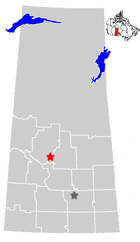
Saskatchewan Highway 7
Encyclopedia
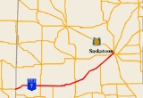
Saskatchewan Highway 7 is a major paved undivided provincial highway
in the Canadian
province of Saskatchewan
, running from the Alberta
border to Saskatoon. Highway 7 continues west into Alberta where it becomes Alberta Highway 9.
Highway 7 is an important trade and travel route linking Saskatoon with several of its bedroom communities such as Delisle
and Vanscoy
, as well as larger centres farther afield such as Rosetown
and Kindersley
. Its primary use, however, is by travelers heading for Calgary, Alberta and the Canadian west coast.
Despite being one of the most heavily used roads in the province, as of 2006 only a small portion between Saskatoon and Vanscoy, and a very short stretch outside of Rosetown, has been divided. Some oil exploration has been undertaken in the western region of the highway, however agriculture is the main industry of the area. Agrium Vanscoy Potash Operations is Canada's third largest producer of potash
fertilizer. In the 1930s early homesteaders would maintain Highway 7 as a means to supplement their income. Provincial Highway 7 followed the Canadian Northern railway grade for direction of travel with the actual road way being on the square on the Dominion survey township lines. Highway 7 was widened in 1944 and rebuilt between 1960 and 1961.
Highway 7 currently terminates at its junction with 22nd Street West (Highway 14
) in west Saskatoon. In 2005, work began on realigning Highway 7 in order to make way for the Blairmore Suburban Centre
development including the Bethlehem High School
, Tommy Douglas Collegiate
and the Shaw Centre located where Highway 7 linked with 22nd Street prior to 2006. Realignment is being conducted in two phases.
 The entirety of Highway 7 is a primary weight asphalt concrete (AS)
national highway within the Ministry of Highways and Infrastructure
(SHS) West Central Municipal Government Committee planning jurisdiction. Travel on Highway 7 begins east at the Alberta
- Saskatchewan
provincial border through the Missouri Coteau which features mixed prairie vegetation
. Entering Alberta, the highway continues west as Alberta Highway 9. Alsask
is a village
of about 150 people on the border and Highway 44
. The Military Dome site radar station is a heritage site and has been acquired by Alsask along with the 1960s airforce base. At Alsask, Highway 7 turns north east until km 3.9 when again the highway is routed east. Again at km 6.1 the highway turns north east until km 19.8 just past the intersection with Highway 317
. Marengo
, a small village of about 50 residents is 0.8 kilometre (0.497098189319845 mi) north of the junction. Highway 7 continues for several kilometres east reaching the village of Flaxcombe
, which has a population of just over 100. Highway 307
north provides access to the villages of Coleville and Smiley. This area belongs to the West Central Regional Economic Development Authority (REDA). The town of Kindersley
is the largest center featuring both oil and agricultural industries along Highway 7 and with a population of about 4,500 is almost at city status of 5,000 residents. The Average Annual Daily Traffic (AADT) ranges from approximately 1,600 to 2,000 vehicles per day (vpd) near the Alberta
-Saskatchewan border to over 3,000 vpd near Kindersley. Continuing east, Highway 7 comes to a short 1.6 kilometre (0.994196378639691 mi) concurrency between Highway 658
south and Highway 658 north. The village of Netherhill
is also located between the Highway 658 junction and Highway 30 junction.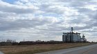 Highway 30
south provides access to the hamlet of McMorran. The highway takes a few gentle curves north east at km 106.1 through the unincorporated areas of Fiske
and McGee to the junction with Highway 4
. Rosetown
is a town about half the size of Kindersley located at this junction. The Goose Lake Plain landscape area of the Moist Mixed Prairie
ecoregion
is the main feature between Rosetown and Saskatoon. The bearing of the highway continues north east until the town of Zealandia
whose population is hovering around 100 people. After Zealandia, the highway continues in a north-northeast direction coming to junction with Highway 768
north and the junction with Highway 655 west and with Highway 655 south. The village of Tessier is next along this north east section of highway, and then Delisle
. Delisle, a town, with a population of about 800 residents is located at the intersection of Highway 7, Highway 45
south, and Saskatchewan Highway 673
east on the south west side of town. The AADT along the route fluctuates between 2,000 and 3,000 vpd until Delisle. The intersection with Highway 766
is to the north east of Delisle. The corner of Highway 672
(South and east) is at the intersection with Highway 7 at the village of Vanscoy
. Agrium Vanscoy Potash Mine is located 32 kilometres (19.9 mi) south west of Saskatoon, just to the north west of Vanscoy
. The potash mine was established in 1931 as Cominco Fertilizers Ltd. changing names in 1995 to Agrium Inc., the nation's third largest producer of potash The AADT on Highway 7 near Vanscoy increases to over 5,600 vpd. Both Highway 672 east and Highway 766 east provide access to Pike Lake Provincial Park
. Highway 7 continues north westerly arriving at the first interchange at km 249.7 with Highway 60
south. The twinned overpass is 1.5 kilometre (0.93205910497471 mi) in length continuing on as a 10 kilometres (6.2 mi) length of twinned
highway. This twinned section of the highway
handles between 7,000 to 12,000 vpd on average throughout the year. The 11th Street West intersection provides access from the south end of the City of Saskatoon
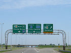
to Highway 7. Highway 7 becomes concurrent with Highway 14
at the west end of Saskatoon. This is the new Blairmore Suburban Development Area (SDA)
hosting seven new neighbourhods and a future interchange at the intersection of Highway 14 west, Highway 11 south, Dalmeny Road north, and 22nd Street east. Highway 7 continues east along 22nd Street East, concurrent with Highway 14. There are two routes through Saskatoon; one is on Circle Drive
north ending at SK Hwy 16
the Yellowhead Trans Canada Highway and Idylwyld Drive North, the second continues east along 22nd Street East ending at SK Hwy 11
the Louis Riel Trail and Idylwyle Drive North.
 The Old Bone Trail was the name of the red river cart trail between Saskatoon and Rosetown. The Saskatchewan Highway Act was established in 1922, in compliance with the 1919 Canadian highway act. At the initial stages of the Saskatchewan Highway Act, 10 miles (16.1 km) of provincial highways were gravel and the rest were earth roads. The road allowances were laid out as a part of the Dominion Land survey system for homesteading. Travel along the Provincial Highway 7 before the 1940s would have been traveling on the square following the township road allowances, barbed wire fencing and the Canadian Northern rail line. As the surveyed township roads were the easiest to travel, the first highway
was designed on 90-degree, right-angle corners as the distance traversed the prairie along range roads and township roads.
Mr. Ralph Glen Chapman an early 1900s settler in Pleasant Valley
maintained 10 miles (16.1 km) of Highway 7. Mr. Block of the German Mennonite settlement at Fiske maintained a stretch of Highway 7 as a means of supplementing his income in the 1930s. In 1939, Andy Anderson in the same fashion, kept a 10 miles (16.1 km) stretch of Highway 7 clear.
In 1944 the widening of Highway 7 was undertaken. The Elma rural municipality (R.M.)
requested that an automatic warning system should be established at the level crossing of the Canadian National Railway
and Highway 7. At this same time, the rural municipality requested that the hills be gravelled which are situated on either side of Flaxcombe. The third concern in 1948 was to construct an all-weather highway between Kindersley
and Alsask
, and this too was requested of the Department of Highways (DOH). In 1950, the rates of pay for roadwork were 60 cents an hour for a single labourer, 80 cents an hour for man and two horses, a labourer with four horses would earn C$1.00 per hour and for man with six horses $1.20 per hour In the 1950s the R.M. provided grants to the local snow plough club to keep the highway clear after storms. The 1951 oil strike at Coleville resulted in a Husky service station and bulk plant opening at Flaxcombe on Highway 7 in 1955. It was located on the railroad to facilitate loading crude oil into rail cars. Highway 7 was rebuilt between 1960 and 1961.
Highway 7 currently terminates at its junction with 22nd Street West (Highway 14
) in west Saskatoon. In 2005, work began on realigning Highway 7 in order to make way for the Blairmore Suburban Centre
development including the Bethlehem High School
, Tommy Douglas Collegiate
and the Shaw Centre located where Highway 7 linked with 22nd Street prior to 2006. Realignment is being conducted in two phases. Starting in 2006, Highway 7 was linked with Betts Avenue, a new city street, which in turn intersected 22nd Street at a traffic signal. Within the next few years, however, the city and province are expected to build an interchange
farther west (but still with the city limits) at the junction of Highway 14 and Highway 684
(Dalmeny Road), at which point a new Highway 7 roadway will link with this interchange. Long-term plans call for a link to be created from Highway 684 to the Yellowhead Highway
in Saskatoon's north side, though it has not yet been announced whether the Highway 7 designation will be applied north of Highway 14. There are plans for a major construction in 2008-2009 west of Saskatoon on Highway 7.
Highway
A highway is any public road. In American English, the term is common and almost always designates major roads. In British English, the term designates any road open to the public. Any interconnected set of highways can be variously referred to as a "highway system", a "highway network", or a...
in the Canadian
Canada
Canada is a North American country consisting of ten provinces and three territories. Located in the northern part of the continent, it extends from the Atlantic Ocean in the east to the Pacific Ocean in the west, and northward into the Arctic Ocean...
province of Saskatchewan
Saskatchewan
Saskatchewan is a prairie province in Canada, which has an area of . Saskatchewan is bordered on the west by Alberta, on the north by the Northwest Territories, on the east by Manitoba, and on the south by the U.S. states of Montana and North Dakota....
, running from the Alberta
Alberta
Alberta is a province of Canada. It had an estimated population of 3.7 million in 2010 making it the most populous of Canada's three prairie provinces...
border to Saskatoon. Highway 7 continues west into Alberta where it becomes Alberta Highway 9.
Highway 7 is an important trade and travel route linking Saskatoon with several of its bedroom communities such as Delisle
Delisle, Saskatchewan
-References:...
and Vanscoy
Vanscoy, Saskatchewan
-Sites of Interest:Within 19 kilometers or 12 miles of Vanscoy is the Otapasoo Trails Recreation Site. Pike Lake Provincial Park has hiking trails, boating, and marsh land conservation area, and is located 16 kilometers or 10 miles to the south east of Vanscoy. Vade, Hawker, Hawoods, Farley,...
, as well as larger centres farther afield such as Rosetown
Rosetown, Saskatchewan
-History:On September 14, 1905, James and Anne Rose migrated from Lancashire, England to an area of Saskatchewan, Canada. They were the first settlers in the area now known as Rosetown. Later, in 1907, a group of people from the area, wanting a post office, made an application for one...
and Kindersley
Kindersley, Saskatchewan
Kindersley is a town in west central Saskatchewan, Canada, located at Section 10, Township 29, Range 23, West of the 3rd Meridian, along highway 7, a primary highway linking Calgary, Alberta and Saskatoon, Saskatchewan...
. Its primary use, however, is by travelers heading for Calgary, Alberta and the Canadian west coast.
Despite being one of the most heavily used roads in the province, as of 2006 only a small portion between Saskatoon and Vanscoy, and a very short stretch outside of Rosetown, has been divided. Some oil exploration has been undertaken in the western region of the highway, however agriculture is the main industry of the area. Agrium Vanscoy Potash Operations is Canada's third largest producer of potash
Potash
Potash is the common name for various mined and manufactured salts that contain potassium in water-soluble form. In some rare cases, potash can be formed with traces of organic materials such as plant remains, and this was the major historical source for it before the industrial era...
fertilizer. In the 1930s early homesteaders would maintain Highway 7 as a means to supplement their income. Provincial Highway 7 followed the Canadian Northern railway grade for direction of travel with the actual road way being on the square on the Dominion survey township lines. Highway 7 was widened in 1944 and rebuilt between 1960 and 1961.
Highway 7 currently terminates at its junction with 22nd Street West (Highway 14
Saskatchewan Highway 14
Highway 14 is a highway in the Canadian province of Saskatchewan. It runs from the intersection of Idylwyld Drive and 22nd Street in downtown Saskatoon, westward to the Albertan border where it becomes Highway 13. It is approximately 261 km long.Prior to the 1970's, Highway 14 ran the width...
) in west Saskatoon. In 2005, work began on realigning Highway 7 in order to make way for the Blairmore Suburban Centre
Blairmore SDA, Saskatoon
Blairmore Suburban Development Area is an area in Saskatoon, Saskatchewan . It is a part of the west side community of Saskatoon. It lies north of the outskirts of the City and the Rural Municipality of Corman Park No. 344, west of downtown Saskatoon, and the Core Neighbourhoods SDA, south of...
development including the Bethlehem High School
Bethlehem High School (Saskatoon)
Bethlehem Catholic High School opened in August 2007 for students in Grades 9 and 10. It is located at the west end of 22nd Street in the Blairmore Suburban Centre neighbourhood.Bethlehem serves students living on the west side of Circle Drive...
, Tommy Douglas Collegiate
Tommy Douglas Collegiate
Tommy Douglas Collegiate Institute is a high school located in western Saskatoon, Saskatchewan, serving students from grades 9 through 12. It is named for Tommy Douglas, leader of the Saskatchewan Co-operative Commonwealth Federation and premier of Saskatchewan from 1944-1961.-Sports:-External...
and the Shaw Centre located where Highway 7 linked with 22nd Street prior to 2006. Realignment is being conducted in two phases.
Travel route
Asphalt concrete
Asphalt concrete is a composite material commonly used in construction projects such as road surfaces, airports and parking lots. It consists of asphalt and mineral aggregate mixed together, then laid down in layers and compacted...
national highway within the Ministry of Highways and Infrastructure
Ministry of Highways and Infrastructure (Saskatchewan)
The Ministry of Highways and Infrastructure or Highways and Infrastructure — Government of Saskatchewan Ministry of Highways is divided into the Operations, Policy and Programs, and Corporate Services Divisions and the Communications Branch. The ministry is the employer of over 1,476...
(SHS) West Central Municipal Government Committee planning jurisdiction. Travel on Highway 7 begins east at the Alberta
Alberta
Alberta is a province of Canada. It had an estimated population of 3.7 million in 2010 making it the most populous of Canada's three prairie provinces...
- Saskatchewan
Saskatchewan
Saskatchewan is a prairie province in Canada, which has an area of . Saskatchewan is bordered on the west by Alberta, on the north by the Northwest Territories, on the east by Manitoba, and on the south by the U.S. states of Montana and North Dakota....
provincial border through the Missouri Coteau which features mixed prairie vegetation
Flora of Saskatchewan
The native flora of the Saskatchewan includes vascular plants, plus additional species of other plants and plant-like organisms such as algae, lichens and other fungi, and mosses...
. Entering Alberta, the highway continues west as Alberta Highway 9. Alsask
Alsask, Saskatchewan
Alsask is part of the Heartland Regional Health Authority with SaskHealth reporting Alsask as having a population of 148 -Climate:Alsask experiences a semi-arid climate . Winters are long, cold and dry, while summers are short and warm...
is a village
Village
A village is a clustered human settlement or community, larger than a hamlet with the population ranging from a few hundred to a few thousand , Though often located in rural areas, the term urban village is also applied to certain urban neighbourhoods, such as the West Village in Manhattan, New...
of about 150 people on the border and Highway 44
Saskatchewan Highway 44
Highway 44 is a highway in the Canadian province of Saskatchewan. It runs from Highway 7 near Alsask to Highway 11 near Davidson. Highway 44 is about 331 km long....
. The Military Dome site radar station is a heritage site and has been acquired by Alsask along with the 1960s airforce base. At Alsask, Highway 7 turns north east until km 3.9 when again the highway is routed east. Again at km 6.1 the highway turns north east until km 19.8 just past the intersection with Highway 317
Saskatchewan Highway 317
Highway 317 is a highway in the Canadian province of Saskatchewan. It runs from Highway 7 near Primate. Highway 317 is about 96 km long.-Intersections from south to north:...
. Marengo
Marengo, Saskatchewan
Marengo is a village in west central Saskatchewan, Canada, about 45 km west of Kindersley. It is located within the Sun West School Division.-External links:*...
, a small village of about 50 residents is 0.8 kilometre (0.497098189319845 mi) north of the junction. Highway 7 continues for several kilometres east reaching the village of Flaxcombe
Flaxcombe, Saskatchewan
- See also :* List of communities in Saskatchewan* Villages of Saskatchewan-External links:********-Footnotes:...
, which has a population of just over 100. Highway 307
Saskatchewan Highway 307
Highway 307 is a highway in the Canadian province of Saskatchewan. It runs from Highway 7 to Highway 21. Highway 307 is about 47 km long....
north provides access to the villages of Coleville and Smiley. This area belongs to the West Central Regional Economic Development Authority (REDA). The town of Kindersley
Kindersley, Saskatchewan
Kindersley is a town in west central Saskatchewan, Canada, located at Section 10, Township 29, Range 23, West of the 3rd Meridian, along highway 7, a primary highway linking Calgary, Alberta and Saskatoon, Saskatchewan...
is the largest center featuring both oil and agricultural industries along Highway 7 and with a population of about 4,500 is almost at city status of 5,000 residents. The Average Annual Daily Traffic (AADT) ranges from approximately 1,600 to 2,000 vehicles per day (vpd) near the Alberta
Alberta
Alberta is a province of Canada. It had an estimated population of 3.7 million in 2010 making it the most populous of Canada's three prairie provinces...
-Saskatchewan border to over 3,000 vpd near Kindersley. Continuing east, Highway 7 comes to a short 1.6 kilometre (0.994196378639691 mi) concurrency between Highway 658
Saskatchewan Highway 658
Saskatchewan Highway 658 connects Saskatchewan Highway 4 near Red Pheasant Indian Reserve 108 to SK Hwy 4 near Battleford. Highway 658 travels around Mosquito Indian Reserve 109, whereas Highway 4 travels north through the Indian Reserve. To the north of Mosquito Indian Reserve 109 is Grizzly...
south and Highway 658 north. The village of Netherhill
Netherhill, Saskatchewan
-External links:********-Footnotes:...
is also located between the Highway 658 junction and Highway 30 junction.
Saskatchewan Highway 30
Highway 30 is a highway in the Canadian province of Saskatchewan. It runs from the Eston Riverside Regional Park on the South Saskatchewan River until Highway 7. Highway 30 is about 61 km long.-Intersections from south to north:...
south provides access to the hamlet of McMorran. The highway takes a few gentle curves north east at km 106.1 through the unincorporated areas of Fiske
Fiske, Saskatchewan
Fiske is a small rural farming community of about 120 people in West Central Saskatchewan, Canada.- Economy :Grain farming, ranching, and trades are the main sectors in which Fiskinites are employed....
and McGee to the junction with Highway 4
Saskatchewan Highway 4
Highway 4 is a major highway in the Canadian province of Saskatchewan. It runs from U.S. Route 191 at the United States border near Monchy to Highway 224/Highway 904 at Meadow Lake Provincial Park. Highway 4 is about 653 km long....
. Rosetown
Rosetown, Saskatchewan
-History:On September 14, 1905, James and Anne Rose migrated from Lancashire, England to an area of Saskatchewan, Canada. They were the first settlers in the area now known as Rosetown. Later, in 1907, a group of people from the area, wanting a post office, made an application for one...
is a town about half the size of Kindersley located at this junction. The Goose Lake Plain landscape area of the Moist Mixed Prairie
Flora of Saskatchewan
The native flora of the Saskatchewan includes vascular plants, plus additional species of other plants and plant-like organisms such as algae, lichens and other fungi, and mosses...
ecoregion
Ecoregion
An ecoregion , sometimes called a bioregion, is an ecologically and geographically defined area that is smaller than an ecozone and larger than an ecosystem. Ecoregions cover relatively large areas of land or water, and contain characteristic, geographically distinct assemblages of natural...
is the main feature between Rosetown and Saskatoon. The bearing of the highway continues north east until the town of Zealandia
Zealandia, Saskatchewan
-External links:**-Footnotes:...
whose population is hovering around 100 people. After Zealandia, the highway continues in a north-northeast direction coming to junction with Highway 768
Saskatchewan Highway 768
Highway 768 is a highway in the Canadian province of Saskatchewan. It runs from Highway 7 near Harris to Highway 4. Highway 768 is about 35 km long....
north and the junction with Highway 655 west and with Highway 655 south. The village of Tessier is next along this north east section of highway, and then Delisle
Delisle, Saskatchewan
-References:...
. Delisle, a town, with a population of about 800 residents is located at the intersection of Highway 7, Highway 45
Saskatchewan Highway 45
Highway 45 is a highway in the Canadian province of Saskatchewan. It runs from Highway 42/Highway 646 near Lucky Lake to Highway 7 near Delisle. Highway 45 is about 116 km long....
south, and Saskatchewan Highway 673
Saskatchewan Highway 673
Highway 673 is a highway in the Canadian province of Saskatchewan. It runs from Highway 7 near Delisle to Highway 14 near Asquith Station and Asquith. Highway 673 is about 28 km long....
east on the south west side of town. The AADT along the route fluctuates between 2,000 and 3,000 vpd until Delisle. The intersection with Highway 766
Saskatchewan Highway 766
Highway 766 is a highway in the Canadian province of Saskatchewan. It runs from Highway 7 at Delisle to Highway 60. Highway 766 is about 23 km long.-Intersections from west to east:...
is to the north east of Delisle. The corner of Highway 672
Saskatchewan Highway 672
Highway 672 is a highway in the Canadian province of Saskatchewan. It runs from Highway 7 near Vanscoy to Highway 16. Highway 672 is about 51 km long....
(South and east) is at the intersection with Highway 7 at the village of Vanscoy
Vanscoy, Saskatchewan
-Sites of Interest:Within 19 kilometers or 12 miles of Vanscoy is the Otapasoo Trails Recreation Site. Pike Lake Provincial Park has hiking trails, boating, and marsh land conservation area, and is located 16 kilometers or 10 miles to the south east of Vanscoy. Vade, Hawker, Hawoods, Farley,...
. Agrium Vanscoy Potash Mine is located 32 kilometres (19.9 mi) south west of Saskatoon, just to the north west of Vanscoy
Vanscoy, Saskatchewan
-Sites of Interest:Within 19 kilometers or 12 miles of Vanscoy is the Otapasoo Trails Recreation Site. Pike Lake Provincial Park has hiking trails, boating, and marsh land conservation area, and is located 16 kilometers or 10 miles to the south east of Vanscoy. Vade, Hawker, Hawoods, Farley,...
. The potash mine was established in 1931 as Cominco Fertilizers Ltd. changing names in 1995 to Agrium Inc., the nation's third largest producer of potash The AADT on Highway 7 near Vanscoy increases to over 5,600 vpd. Both Highway 672 east and Highway 766 east provide access to Pike Lake Provincial Park
Pike Lake Provincial Park
Pike Lake Provincial Park is a primarily recreational park located approximately 32 km southwest of Saskatoon, Saskatchewan. It is located at the southern terminus of Highway 60 on the shore of Pike Lake, an oxbow created by the South Saskatchewan River...
. Highway 7 continues north westerly arriving at the first interchange at km 249.7 with Highway 60
Saskatchewan Highway 60
Highway 60 is a provincial highway in the Canadian province of Saskatchewan. It runs from Highway 7 near Saskatoon to Pike Lake Provincial Park. The highway is approximately 26 km long....
south.
Dual carriageway
A dual carriageway is a class of highway with two carriageways for traffic travelling in opposite directions separated by a central reservation...
highway. This twinned section of the highway
handles between 7,000 to 12,000 vpd on average throughout the year. The 11th Street West intersection provides access from the south end of the City of Saskatoon
Saskatoon
Saskatoon is a city in central Saskatchewan, Canada, on the South Saskatchewan River. Residents of the city of Saskatoon are called Saskatonians. The city is surrounded by the Rural Municipality of Corman Park No. 344....
to Highway 7. Highway 7 becomes concurrent with Highway 14
Saskatchewan Highway 14
Highway 14 is a highway in the Canadian province of Saskatchewan. It runs from the intersection of Idylwyld Drive and 22nd Street in downtown Saskatoon, westward to the Albertan border where it becomes Highway 13. It is approximately 261 km long.Prior to the 1970's, Highway 14 ran the width...
at the west end of Saskatoon. This is the new Blairmore Suburban Development Area (SDA)
Blairmore SDA, Saskatoon
Blairmore Suburban Development Area is an area in Saskatoon, Saskatchewan . It is a part of the west side community of Saskatoon. It lies north of the outskirts of the City and the Rural Municipality of Corman Park No. 344, west of downtown Saskatoon, and the Core Neighbourhoods SDA, south of...
hosting seven new neighbourhods and a future interchange at the intersection of Highway 14 west, Highway 11 south, Dalmeny Road north, and 22nd Street east. Highway 7 continues east along 22nd Street East, concurrent with Highway 14. There are two routes through Saskatoon; one is on Circle Drive
Circle Drive
Circle Drive is a major road constructed as a ring road in Saskatoon, Saskatchewan, Canada. The northeastern portion of the road is part of the Yellowhead Highway.-History:...
north ending at SK Hwy 16
Saskatchewan Highway 16
Highway 16 is a provincial paved highway in the Canadian province of Saskatchewan. It is the Saskatchewan section of the Yellowhead Highway, and also the Trans-Canada Highway Yellowhead section. The main purpose of this highway is to connect Saskatchewan with Canadian cities such as Edmonton and...
the Yellowhead Trans Canada Highway and Idylwyld Drive North, the second continues east along 22nd Street East ending at SK Hwy 11
Saskatchewan Highway 11
Highway 11 is a major north-south highway in Saskatchewan, Canada that connects the province's three largest cities: Regina, Saskatoon and Prince Albert. It is a structural pavement major arterial highway which is approximately long. It is also known as the Louis Riel Trail after the 19th century...
the Louis Riel Trail and Idylwyle Drive North.
History
Roads in Saskatchewan
Saskatchewan, the middle of Canada's three prairie provinces, has an area of and population of 990,212 , mostly living in the southern half of the province....
was designed on 90-degree, right-angle corners as the distance traversed the prairie along range roads and township roads.
Mr. Ralph Glen Chapman an early 1900s settler in Pleasant Valley
Pleasant Valley No. 288, Saskatchewan
Pleasant Valley No. 288 is a rural municipality in the Canadian province of Saskatchewan. The municipality is located in the Census Division 12 which is a part of SARM Division 6. The seat of the municipality is located in the Town of Rosetown.-Demographics:...
maintained 10 miles (16.1 km) of Highway 7. Mr. Block of the German Mennonite settlement at Fiske maintained a stretch of Highway 7 as a means of supplementing his income in the 1930s. In 1939, Andy Anderson in the same fashion, kept a 10 miles (16.1 km) stretch of Highway 7 clear.
In 1944 the widening of Highway 7 was undertaken. The Elma rural municipality (R.M.)
Rural municipality
A rural municipality, often abbreviated RM, is a form of municipality in the Canadian provinces of Manitoba and Saskatchewan, perhaps best comparable to counties or townships in the western United States...
requested that an automatic warning system should be established at the level crossing of the Canadian National Railway
Canadian National Railway
The Canadian National Railway Company is a Canadian Class I railway headquartered in Montreal, Quebec. CN's slogan is "North America's Railroad"....
and Highway 7. At this same time, the rural municipality requested that the hills be gravelled which are situated on either side of Flaxcombe. The third concern in 1948 was to construct an all-weather highway between Kindersley
Kindersley, Saskatchewan
Kindersley is a town in west central Saskatchewan, Canada, located at Section 10, Township 29, Range 23, West of the 3rd Meridian, along highway 7, a primary highway linking Calgary, Alberta and Saskatoon, Saskatchewan...
and Alsask
Alsask, Saskatchewan
Alsask is part of the Heartland Regional Health Authority with SaskHealth reporting Alsask as having a population of 148 -Climate:Alsask experiences a semi-arid climate . Winters are long, cold and dry, while summers are short and warm...
, and this too was requested of the Department of Highways (DOH). In 1950, the rates of pay for roadwork were 60 cents an hour for a single labourer, 80 cents an hour for man and two horses, a labourer with four horses would earn C$1.00 per hour and for man with six horses $1.20 per hour In the 1950s the R.M. provided grants to the local snow plough club to keep the highway clear after storms. The 1951 oil strike at Coleville resulted in a Husky service station and bulk plant opening at Flaxcombe on Highway 7 in 1955. It was located on the railroad to facilitate loading crude oil into rail cars. Highway 7 was rebuilt between 1960 and 1961.
Highway 7 currently terminates at its junction with 22nd Street West (Highway 14
Saskatchewan Highway 14
Highway 14 is a highway in the Canadian province of Saskatchewan. It runs from the intersection of Idylwyld Drive and 22nd Street in downtown Saskatoon, westward to the Albertan border where it becomes Highway 13. It is approximately 261 km long.Prior to the 1970's, Highway 14 ran the width...
) in west Saskatoon. In 2005, work began on realigning Highway 7 in order to make way for the Blairmore Suburban Centre
Blairmore SDA, Saskatoon
Blairmore Suburban Development Area is an area in Saskatoon, Saskatchewan . It is a part of the west side community of Saskatoon. It lies north of the outskirts of the City and the Rural Municipality of Corman Park No. 344, west of downtown Saskatoon, and the Core Neighbourhoods SDA, south of...
development including the Bethlehem High School
Bethlehem High School (Saskatoon)
Bethlehem Catholic High School opened in August 2007 for students in Grades 9 and 10. It is located at the west end of 22nd Street in the Blairmore Suburban Centre neighbourhood.Bethlehem serves students living on the west side of Circle Drive...
, Tommy Douglas Collegiate
Tommy Douglas Collegiate
Tommy Douglas Collegiate Institute is a high school located in western Saskatoon, Saskatchewan, serving students from grades 9 through 12. It is named for Tommy Douglas, leader of the Saskatchewan Co-operative Commonwealth Federation and premier of Saskatchewan from 1944-1961.-Sports:-External...
and the Shaw Centre located where Highway 7 linked with 22nd Street prior to 2006. Realignment is being conducted in two phases. Starting in 2006, Highway 7 was linked with Betts Avenue, a new city street, which in turn intersected 22nd Street at a traffic signal. Within the next few years, however, the city and province are expected to build an interchange
Interchange (road)
In the field of road transport, an interchange is a road junction that typically uses grade separation, and one or more ramps, to permit traffic on at least one highway to pass through the junction without directly crossing any other traffic stream. It differs from a standard intersection, at which...
farther west (but still with the city limits) at the junction of Highway 14 and Highway 684
Saskatchewan Highway 684
Highway 684 is the name given to two different highways in the Canadian province of Saskatchewan.The northwestern Highway 684 is approximately 57 km long. It begins near Waseca, at Highway 16, and it ends at Highway 3....
(Dalmeny Road), at which point a new Highway 7 roadway will link with this interchange. Long-term plans call for a link to be created from Highway 684 to the Yellowhead Highway
Yellowhead Highway
The Yellowhead Highway is a major east-west highway connecting the four western Canadian provinces of British Columbia, Alberta, Saskatchewan, and Manitoba. Although part of the Trans-Canada Highway system, the highway should not be confused with the more southerly, originally-designated...
in Saskatoon's north side, though it has not yet been announced whether the Highway 7 designation will be applied north of Highway 14. There are plans for a major construction in 2008-2009 west of Saskatoon on Highway 7.