
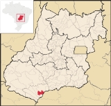
Paranaiguara
Encyclopedia
| Paranaiguara | |
|---|---|
| State | Goiás Goiás Goiás is a state of Brazil, located in the central part of the country. The name Goiás comes from the name of an indigenous community... |
| Coordinates: | 18°54′25"S 50°39′19"W |
| Area: | 1,153.7 km² |
| Population: | 7,724 (IBGE 2007) |
| Elevation: | 4796m above sea level |
| Postcode (CEP): | 75880-000 |
| Became a municipality: | 1953 |
| Mayor: | Lázaro Soares de Aquino (2005) |
| IBGE statistical Microregion: | Quirinópolis Microregion Quirinópolis Microregion The Quirinópolis Microregion is a region in south Goiás state, Brazil. It includes 8 municipalities with a population of 95,094 and a total area of 16,117.60 km². The population density was 5.89 km²... |
| Distance to Goiânia Goiânia -Climate:The city has a tropical wet and dry climate with an average temperature of . There's a wet season, from October to April, and a dry one, from May to September. Annual rainfall is around 1,520 mm.... : |
351 km. |
| Website: | none (March 2008) |
Town
A town is a human settlement larger than a village but smaller than a city. The size a settlement must be in order to be called a "town" varies considerably in different parts of the world, so that, for example, many American "small towns" seem to British people to be no more than villages, while...
and municipality
Municipality
A municipality is essentially an urban administrative division having corporate status and usually powers of self-government. It can also be used to mean the governing body of a municipality. A municipality is a general-purpose administrative subdivision, as opposed to a special-purpose district...
in south Goiás
Goiás
Goiás is a state of Brazil, located in the central part of the country. The name Goiás comes from the name of an indigenous community...
state, Brazil
Brazil
Brazil , officially the Federative Republic of Brazil , is the largest country in South America. It is the world's fifth largest country, both by geographical area and by population with over 192 million people...
.
Location and Geography
Paranaiguara is in the Quirinópolis MicroregionQuirinópolis Microregion
The Quirinópolis Microregion is a region in south Goiás state, Brazil. It includes 8 municipalities with a population of 95,094 and a total area of 16,117.60 km². The population density was 5.89 km²...
, whose most important city is Quirinópolis
Quirinópolis
Quirinópolis is a small city and municipality in south Goiás state, Brazil. It is a large producer of cattle and agricultural products.-Location:...
. The distance to the state capital, Goiânia
Goiânia
-Climate:The city has a tropical wet and dry climate with an average temperature of . There's a wet season, from October to April, and a dry one, from May to September. Annual rainfall is around 1,520 mm....
, is 351 km. Highway connections are made by BR-060 / Abadia de Goiás
Abadia de Goiás
Abadia de Goiás is a small town and municipality in central Goiás state, Brazil, located on the western edge of the Goiânia metropolitan area.-Geographical Data:The distance to Goiânia is 27 km...
/ Guapó
Guapó
Guapó is a small town and municipality in central Goiás state, Brazil. The population was 13,586 and the total area of the municipality was 517.0 km² .Guapó is part of the Goiânia Microregion...
/ Indiara
Indiara
Indiara is a small city and municipality in central-south Goiás state, Brazil. Indiara is a large producer of soybeans and cotton.-Location:Indiara is located in the Vale do Rio dos Bois and has municipal boundaries with:*north: Palmeiras de Goiás...
/ Acreúna
Acreúna
Acreúna is a small city and municipality in western Goiás state, Brazil.-Location:Acreúna is located in the statistical micro-region of Vale do Rio dos Bois, southwest of the state capital, Goiânia, on BR-060, which links Goiânia with Rio Verde...
/ GO-164 / Quirinópolis
Quirinópolis
Quirinópolis is a small city and municipality in south Goiás state, Brazil. It is a large producer of cattle and agricultural products.-Location:...
/ BR-483 / GO-164. See Sepin
There are municipal boundaries with:
- north: QuirinópolisQuirinópolisQuirinópolis is a small city and municipality in south Goiás state, Brazil. It is a large producer of cattle and agricultural products.-Location:...
- south: São SimãoSão Simão, GoiásSão Simão is a small town and a municipality in south-central Goiás state, Brazil.-Location:São Simão is strategically situated on the border of Goiás with Minas Gerais, which makes it a major river navigation link between central Brazil, the Prata river system and the South Atlantic...
- east: São Simão and Santa Vitória, Minas Gerais
- west: Cachoeira AltaCachoeira AltaCachoeira Alta is a small town and municipality in south Goiás state, Brazil. The population was 8,103 inhabitants in 2007 in a total area of 1659.4 km². Cachoeira Alta has one of the largest cattle herds in the state.-Location:...
and CaçuCaçuCaçu is a small town and municipality in southwest Goiás state, Brazil.-Location:Caçu is part of the Quirinópolis Microregion. It is located 330 kilometers from the state capital, Goiânia and is crossed by highway GO-206, which links the city with Quirinópolis...
The climate is temperate tropical, with an average annual temperature of 26 °C. There are maximums of 26 °C and minimums of 10 °C. The main river is the Paranaíba
Paranaíba River
The Paranaíba River is a Brazilian river whose source lies in the state of Minas Gerais in the Mata da Corda mountains, municipality of Rio Paranaíba, at an altitude of 1,148 meters; on the other face of this mountain chain are the sources of the Abaeté river, tributary of the São Francisco River...
, which has tributaries such as the Rio Claro and Ribeirão Alegre.
Demographics
- Population density in 2007: 6.69 inhab/km²
- Population growth rate 1996/2007: -0.67.%
- Total population in 2007: 7,724
- Total population in 1980: 6,782
- Urban population in 2007: 6,991
- Rural population in 2007: 733
- Population change: the population has increased by about 960 inhabitants since 1980.
The economy
The economy is based on agriculture, cattle raising, services, public administration, and small transformation industries. In the secondary sector there are clothing industries, brickworks, and a paving company. The cattle herd had 110,000 head (2006) and the main agricultural crops were corn and soybeans.Economic Data (2007)
- Industrial establishments: 18
- Financial institutions: Banco Itaú S.A. (August/2007)
- Retail establishments in 2007: 88
- Automobiles: 976 (2007)
Main agricultural products in ha.(2006)
- rice: 170
- manioc: 40
- corn: 200
- soybeans: 400
Farm Data (2006)in ha.
- Number of farms: 239
- Total area: 92,485
- Area of permanent crops: 78
- Area of perennial crops: 1,433
- Area of natural pasture: 71,227
- Persons dependent on farming: 566
- Farms with tractors: 102
- Number of tractors: 143 IBGE
Education and Health
There were 05 schools (2006) and 01 hospital with 23 beds (2007).- Adult literacy rate: 84.3% (2000) (national average was 86.4%)
- Infant mortality rate: 22.10 (2000) (national average was 33.0)
- Ranking on the Municipal Human Development IndexHuman Development IndexThe Human Development Index is a composite statistic used to rank countries by level of "human development" and separate "very high human development", "high human development", "medium human development", and "low human development" countries...
: 0.751 (middle)
For the complete list see Frigoletto.com
History
Paranaiguara began in the 1930s when diamond prospectors came into the area. In 1950 the settlement became a district of QuirinópolisQuirinópolis
Quirinópolis is a small city and municipality in south Goiás state, Brazil. It is a large producer of cattle and agricultural products.-Location:...
and in 1967 it got its emancipation with the present name. The name means "inhabitants of the great river" in Tupi-guarani. In 1976 the construction of the São Simão Dam
São Simão Dam
The São Simão Dam is an embankment dam on the Paranaíba River near São Simão in Goiás/Minas Gerais, Brazil. It was constructed for hydroelectric power production and flood control. The dam was completed in 1978 and all generators were operational by 1979...
and reservoir forced the evacuation of the old town, which was moved 15 kilometers away.
See also
- List of municipalities in Goiás
- Microregions of Goiás
- Quirinópolis MicroregionQuirinópolis MicroregionThe Quirinópolis Microregion is a region in south Goiás state, Brazil. It includes 8 municipalities with a population of 95,094 and a total area of 16,117.60 km². The population density was 5.89 km²...