
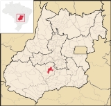
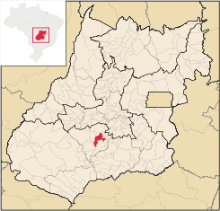
Indiara
Encyclopedia
| Indiara | |
|---|---|
| State | Goiás Goiás Goiás is a state of Brazil, located in the central part of the country. The name Goiás comes from the name of an indigenous community... |
| Area: | 956.4 km² |
| Population: | 13,703 (IBGE 2007) |
| Elevation: | 550 m above sea level |
| Postcode (CEP): | 75955-000 |
| Became a city: | 1982 |
| Distance to Goiânia Goiânia -Climate:The city has a tropical wet and dry climate with an average temperature of . There's a wet season, from October to April, and a dry one, from May to September. Annual rainfall is around 1,520 mm.... : |
102 km. |
| IBGE statistical microregion: | Vale do Rio dos Bois |
| Website: | |
Municipality
A municipality is essentially an urban administrative division having corporate status and usually powers of self-government. It can also be used to mean the governing body of a municipality. A municipality is a general-purpose administrative subdivision, as opposed to a special-purpose district...
in central-south Goiás
Goiás
Goiás is a state of Brazil, located in the central part of the country. The name Goiás comes from the name of an indigenous community...
state, Brazil
Brazil
Brazil , officially the Federative Republic of Brazil , is the largest country in South America. It is the world's fifth largest country, both by geographical area and by population with over 192 million people...
. Indiara is a large producer of soybeans and cotton.
Location
Indiara is located in the Vale do Rio dos Bois and has municipal boundaries with:- north: Palmeiras de GoiásPalmeiras de GoiásPalmeiras de Goiás is a small city and municipality in southestern Goiás state, Brazil.-Location:Palmeiras de Goiás is located in the statistical micro-region of Vale do Rio dos Bois at a distance of 88 kilometers from the state capital, Goiânia. It is 26 kilometers from Cezarina and the important...
- south: EdéiaEdéiaEdéia is a small city and municipality in south-central Goiás state, Brazil.-Municipal Boundaries:Edéia is in the Vale do Rio dos Boisstatistical micro-region and has municipal boundaries with:*north: Indiara*west: Acreúna and Turvelândia...
- east: CezarinaCezarinaCezarina is a municipality in central Goiás state, Brazil.-Location and Communications:Cezarina belongs to the Vale do Rio dos Bois statistical micro-region. It has municipal boundaries with:*north: Palmeiras de Goiás*south: Edealina*east: Varjão...
- west: JandaiaJandaiaJandaia is a small town and municipality in the eastern portion of the Brazilian state of Goiás.-Location and connections:Jandaia has municipal boundaries with:*Northwest: Palmeiras de Goiás*Northeast: Palminópolis...
and AcreúnaAcreúnaAcreúna is a small city and municipality in western Goiás state, Brazil.-Location:Acreúna is located in the statistical micro-region of Vale do Rio dos Bois, southwest of the state capital, Goiânia, on BR-060, which links Goiânia with Rio Verde...
Indiara is located 102 kilometers (southwest) from the state capital, Goiânia
Goiânia
-Climate:The city has a tropical wet and dry climate with an average temperature of . There's a wet season, from October to April, and a dry one, from May to September. Annual rainfall is around 1,520 mm....
and is on the edge of highway BR-060
(passing through Guapó
Guapó
Guapó is a small town and municipality in central Goiás state, Brazil. The population was 13,586 and the total area of the municipality was 517.0 km² .Guapó is part of the Goiânia Microregion...
and Cezarina
Cezarina
Cezarina is a municipality in central Goiás state, Brazil.-Location and Communications:Cezarina belongs to the Vale do Rio dos Bois statistical micro-region. It has municipal boundaries with:*north: Palmeiras de Goiás*south: Edealina*east: Varjão...
.
Political Data
- Eligible voters: 9,310 (12/2007)
- Mayor: José Vilmar da Fonseca (January 2005)
- Vice-mayor: Antônio Telesforo de Almeida
- Councilmembers: 09
Demographic Data
- Population density: 13.28 inhab/km² (2007)
- Population growth rate 2000/2007: 1.04%
- Urban population in 2007: 10,408
- Rural population in 2007: 2,295
The economy is based on cattle raising and agriculture. There are plantations of corn, rice, and soybeans. There are also several small industries producing furniture, lumber, and clothes.
Economic Data for 2007
- Industrial units: 20
- Retail commercial units: 123
- Banking institutions: Banco do Brasil S.A.
- Dairies: Cooperativa Mista dos Prod. de Leite de Morrinhos Ltda.
- Automobiles: 1,114 in 2007
Main agricultural activities
- Cattle raising: 75,140 head (2006)
- Agriculture: cotton, rice, sugarcane (1,125 hectares), oranges, corn (4,000 hectares), soybeans (7,000 hectares), and tomatoes. Statistics are from Sepin
- Number of farms: 562
- Agricultural area: 83,013
- Planted area: 19,300
- Area in natural pasture: 45,292
- Workers in agriculture: 1,800
Education and Health
- Literacy rate: 85.5% (2000)
- Infant mortality rate: 25.29 in 1,000 live births (2000)
- Schools: 13 (2006)
- Students: 3,428
- Hospitals: 03 (02/ 2007)
- Walk-in clinics: 01
History
The town began with the construction of the highway between GoiâniaGoiânia
-Climate:The city has a tropical wet and dry climate with an average temperature of . There's a wet season, from October to April, and a dry one, from May to September. Annual rainfall is around 1,520 mm....
and Cuiabá
Cuiabá
Under the Koppen climate classification, Cuiaba features a tropical wet and dry climate. Cuiabá is famous for its searing heat, although temperatures in winter can arrive sporadically at 10 degrees, indeed atypical, caused by cold fronts coming from the south, and that may only last one or two...
, Mato Grosso
Mato Grosso
Mato Grosso is one of the states of Brazil, the third largest in area, located in the western part of the country.Neighboring states are Rondônia, Amazonas, Pará, Tocantins, Goiás and Mato Grosso do Sul. It also borders Bolivia to the southwest...
in 1958 First came a restaurant, a "churrascaria"" or steakhouse, and then other people began to arrive. There was no donation of lands; the landowners created the lots themselves. The name, Indiara, comes from a coconut tree, the Indaiá, which grows nearby. Indiara belonged to three municipalities: Edéia
Edéia
Edéia is a small city and municipality in south-central Goiás state, Brazil.-Municipal Boundaries:Edéia is in the Vale do Rio dos Boisstatistical micro-region and has municipal boundaries with:*north: Indiara*west: Acreúna and Turvelândia...
, Jandaia
Jandaia
Jandaia is a small town and municipality in the eastern portion of the Brazilian state of Goiás.-Location and connections:Jandaia has municipal boundaries with:*Northwest: Palmeiras de Goiás*Northeast: Palminópolis...
, and Palmeira de Goiás and was dismembered to create a district and a municipality in 1983.
Ranking on the Municipal Human Development Index
Human Development Index
The Human Development Index is a composite statistic used to rank countries by level of "human development" and separate "very high human development", "high human development", "medium human development", and "low human development" countries...
- MHDI: 0.731
- State ranking: 143 (out of 242 municipalities)
- National ranking: 2,414 (out of 5,507 municipalities)
Data are from 2000. For the complete list see Frigoletto
See also
- List of municipalities in Goiás
- Microregions of Goiás
Sources of Data