

Padukka
Encyclopedia
Padukka is a town in the district of Colombo
in the Western Province of Sri Lanka
. It has a population of roughly 8,000. Elevation 44feet.
Padukka, which is part of the Avissawella
electorate
is situated 33 kilometers east of Colombo, the commercial capital of Sri Lanka, and on the bank of Pusweli Oya
on a high ground surrounded by marshland.
(a major tributary of Kelani Ganga river), at a location where the Arukwathu Oya (stream) joins the Pusweli Oya. It was a well-protected site with marshland and hills surrounding the site. Legend says that the town got its name as it was under the "Naa"(Iron Wood) Trees in the town that the Portuguese
Army rested after being defeated by the Army of King Seethawa Rajasinghe in the battle at the adjoining Hanwella Fort. It was said that the defeated Portuguese army rested there until they settled their minds. Thus in the Sinhala Language it was called "Paha Dukka" ("paha"= vanish; "dukka"= sadness), which became "Padukka" later. The famous "Naa"(Iron Wood) Trees are still present at the town's rest house premises.
Padukka has also played a significant role in other wars against Portuguese occupants as an integral part of the Hewagam Korale which literally means the korale (an administrative division) that provided soldiers (hewa). According to the historical data, Sinhalese soldiers confronted the retreating Portuguese army, chased them down at the current Galagedera junction, and inflicted heavy casualties upon the Portuguese contingent.
Names of satellite villages bear testimony to the rich historical legacy of Sithawake kingdom in current Padukka area. Angampitiya which is just 4 miles from the city centre is believed to be the place where king observed the kind of martial art known as Angam Poraya. Kelimadala is believed to be the play ground of Sithawake royalty. Bope was a thick jungle according to the book Kunsthanthinu hatana( Konstantine's war) written by Alagiyawanna Mukaweti of "Subhasithaya" fame.
Moreover the area called "Legumbima",in the adjoining village, "Udumulla", had been a camp site of Portuguese Army.
(take approximately 1.5hrs for the slow train ride from Colombo - distance 35km). An alternative but comfortable drive (36km from Colombo)is via the Colombo-Avissawella (Highlevel) road (A4 Axis) up to Galagedera junction. From here, one has to take a turn to the right and drive on Horana road to Padukka town(1.5 km). It is one of the borders of Colombo District. Horana, the next town after Padukka, belongs to Kalutara District. Homagama, Horana, Hanwella, Halbarawa and Handapangoda are the adjoining towns to Padukka. Udumulla, Meepe, Galagedera, Liyanwala, Malagala,Yatawatura,Beliaththawila, Kahawala, Menerigama, Poregedara, Kotigamgoda, Bope, Arukwatta, Weragala, Angampitiya, Pitumpe, Uggalla, Wewelpanawa,Diddeniya, Udagama, Dambora, Panaluwa, Angamuwa, Meeriyagalla, Mawathagama, Galkaduwa, Koshena, Watareka, Daampe, Horagala-East, Horagala-West, Kurugala and Madulawa are main satellite villages scattered around Padukka.
, tea
, cinnamon
and coconut
plantations. The building of the Kelani valley railway in 1902, which ran from Colombo to Yatiyantota and Ratnapura
passing Padukka and Avissawella
, also contributed greatly to the growth of the city. In 1871, when the first census in the country was done, the town's population stood at 400.
With rapid urbanization in the country, Padukka and its surrounding villages have started to expand vastly. As a result, the government has carved out a separate divisional secretariat division for Padukka from the Hanwella
division to which it previously belonged. Padukka city has become the main administrative centre of this divisional secretariat whose current population stands at 54395
area, with 95% of the population being Sinhalese. Tamils (both Sri Lankan and Indian) comprise 2.5% while Sri Lankan Moors are also present. 1405 people live in the estae sector in the division. Religious composition is also similar to racial distribution with 95% Buddhists, 1.9% Hindus, 1.1% Christians and 1.7% Muslims.
The number of housing units in the Padukka division, according to the census data of 2001, is 15010 while total number of building units including government buildings is 17065.
The office of the Medical Officer of Health (MOH) the main preventive medicine centre for public health activities in the region is situated on Horana Road in Padukka town. This MOH office has a unique history having dated back to British
colonial era. The Padukka hospital also has a long history in the Sri Lankan medical system.
There is a monumental gas lamp placed in the center of the town to commemorate the peace treaty ending World War I
in 1919. Padukka also has a splendid Rest House run by the Sri Lanka Tourist Board and also a few Guest Houses.
Two out of three Satellite Earth Stations in Sri Lanka are also situated in Padukka. Today Padukka is also famous for having a number of rubber estates while there are substantial amounts of graphite deposits in and around the area. The highest mountain in the Colombo district, Udagama Kanda
(1492ft) lies near Padukka.
Colombo
Colombo is the largest city of Sri Lanka. It is located on the west coast of the island and adjacent to Sri Jayawardenapura Kotte, the capital of Sri Lanka. Colombo is often referred to as the capital of the country, since Sri Jayawardenapura Kotte is a satellite city of Colombo...
in the Western Province of Sri Lanka
Sri Lanka
Sri Lanka, officially the Democratic Socialist Republic of Sri Lanka is a country off the southern coast of the Indian subcontinent. Known until 1972 as Ceylon , Sri Lanka is an island surrounded by the Indian Ocean, the Gulf of Mannar and the Palk Strait, and lies in the vicinity of India and the...
. It has a population of roughly 8,000. Elevation 44feet.
Padukka, which is part of the Avissawella
Avissawella
Avissawella, also known as Seethawakapura or Seethawaka, is a town along the A4 route from Colombo on the Western Coast to Kalmunai in the Eastern Coast of Sri Lanka via Ratnapura, Pelmadulla, Balangoda and Wellawaya.- Overview :...
electorate
Electoral district
An electoral district is a distinct territorial subdivision for holding a separate election for one or more seats in a legislative body...
is situated 33 kilometers east of Colombo, the commercial capital of Sri Lanka, and on the bank of Pusweli Oya
Pusweli Oya
Pusweli Oya is a major tributary of Kelani Ganga river in Sri Lanka.Starting from the hills in Puswelihena in Horana Division of Kalutara District, it flows northwards through a low lying flat land converted into rice fields, which ultimately becomes the stream's flood plain during rainy seasons...
on a high ground surrounded by marshland.
History
The town of Padukka is thought to have been founded as a camp site by the forces of the Seethawaka Kingdom in the 16th century CE, on the banks of the Pusweli OyaPusweli Oya
Pusweli Oya is a major tributary of Kelani Ganga river in Sri Lanka.Starting from the hills in Puswelihena in Horana Division of Kalutara District, it flows northwards through a low lying flat land converted into rice fields, which ultimately becomes the stream's flood plain during rainy seasons...
(a major tributary of Kelani Ganga river), at a location where the Arukwathu Oya (stream) joins the Pusweli Oya. It was a well-protected site with marshland and hills surrounding the site. Legend says that the town got its name as it was under the "Naa"(Iron Wood) Trees in the town that the Portuguese
Portugal
Portugal , officially the Portuguese Republic is a country situated in southwestern Europe on the Iberian Peninsula. Portugal is the westernmost country of Europe, and is bordered by the Atlantic Ocean to the West and South and by Spain to the North and East. The Atlantic archipelagos of the...
Army rested after being defeated by the Army of King Seethawa Rajasinghe in the battle at the adjoining Hanwella Fort. It was said that the defeated Portuguese army rested there until they settled their minds. Thus in the Sinhala Language it was called "Paha Dukka" ("paha"= vanish; "dukka"= sadness), which became "Padukka" later. The famous "Naa"(Iron Wood) Trees are still present at the town's rest house premises.
Padukka has also played a significant role in other wars against Portuguese occupants as an integral part of the Hewagam Korale which literally means the korale (an administrative division) that provided soldiers (hewa). According to the historical data, Sinhalese soldiers confronted the retreating Portuguese army, chased them down at the current Galagedera junction, and inflicted heavy casualties upon the Portuguese contingent.
Names of satellite villages bear testimony to the rich historical legacy of Sithawake kingdom in current Padukka area. Angampitiya which is just 4 miles from the city centre is believed to be the place where king observed the kind of martial art known as Angam Poraya. Kelimadala is believed to be the play ground of Sithawake royalty. Bope was a thick jungle according to the book Kunsthanthinu hatana( Konstantine's war) written by Alagiyawanna Mukaweti of "Subhasithaya" fame.
Moreover the area called "Legumbima",in the adjoining village, "Udumulla", had been a camp site of Portuguese Army.
Location
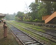
Padukka can be accessed via the B240 (Sri Jayawardanapura - Padukka - Bope highway, earlier B2) highway (33km from Colombo) or by the Kelani Valley Railway LineKelani Valley Railway Line
The Kelani Valley Railway Line, in Sri Lanka, covering the breadth of Colombo District and some parts of Kegalla and Ratnapura Districts is owned, maintained and operated by the Sri Lanka Railways.- History :...
(take approximately 1.5hrs for the slow train ride from Colombo - distance 35km). An alternative but comfortable drive (36km from Colombo)is via the Colombo-Avissawella (Highlevel) road (A4 Axis) up to Galagedera junction. From here, one has to take a turn to the right and drive on Horana road to Padukka town(1.5 km). It is one of the borders of Colombo District. Horana, the next town after Padukka, belongs to Kalutara District. Homagama, Horana, Hanwella, Halbarawa and Handapangoda are the adjoining towns to Padukka. Udumulla, Meepe, Galagedera, Liyanwala, Malagala,Yatawatura,Beliaththawila, Kahawala, Menerigama, Poregedara, Kotigamgoda, Bope, Arukwatta, Weragala, Angampitiya, Pitumpe, Uggalla, Wewelpanawa,Diddeniya, Udagama, Dambora, Panaluwa, Angamuwa, Meeriyagalla, Mawathagama, Galkaduwa, Koshena, Watareka, Daampe, Horagala-East, Horagala-West, Kurugala and Madulawa are main satellite villages scattered around Padukka.
Development
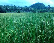
The development of Padukka as an urban center began with the building of a road from Colombo to Ingiriya in the 19th century and the opening of the interior forests with the spreading of rubberRubber
Natural rubber, also called India rubber or caoutchouc, is an elastomer that was originally derived from latex, a milky colloid produced by some plants. The plants would be ‘tapped’, that is, an incision made into the bark of the tree and the sticky, milk colored latex sap collected and refined...
, tea
Tea
Tea is an aromatic beverage prepared by adding cured leaves of the Camellia sinensis plant to hot water. The term also refers to the plant itself. After water, tea is the most widely consumed beverage in the world...
, cinnamon
Cinnamon
Cinnamon is a spice obtained from the inner bark of several trees from the genus Cinnamomum that is used in both sweet and savoury foods...
and coconut
Coconut
The coconut palm, Cocos nucifera, is a member of the family Arecaceae . It is the only accepted species in the genus Cocos. The term coconut can refer to the entire coconut palm, the seed, or the fruit, which is not a botanical nut. The spelling cocoanut is an old-fashioned form of the word...
plantations. The building of the Kelani valley railway in 1902, which ran from Colombo to Yatiyantota and Ratnapura
Ratnapura
- Floods :The town of Ratnapura is situated in the flooding plain of the river Kalu. The town experiences regular floods usually in the month of May. There is no large dam across the Kalu, so this leaves the city at the mercy of nature's forces every year. Several proposals have been made to reduce...
passing Padukka and Avissawella
Avissawella
Avissawella, also known as Seethawakapura or Seethawaka, is a town along the A4 route from Colombo on the Western Coast to Kalmunai in the Eastern Coast of Sri Lanka via Ratnapura, Pelmadulla, Balangoda and Wellawaya.- Overview :...
, also contributed greatly to the growth of the city. In 1871, when the first census in the country was done, the town's population stood at 400.
With rapid urbanization in the country, Padukka and its surrounding villages have started to expand vastly. As a result, the government has carved out a separate divisional secretariat division for Padukka from the Hanwella
Hanwella
Hanwella is a small town in Sri Lanka, situated about 30 km from Colombo, the commercial capital of the country. Hanwella lies on the Colombo-Ratnapura main road, on the banks of the Kelani River.-Geography:...
division to which it previously belonged. Padukka city has become the main administrative centre of this divisional secretariat whose current population stands at 54395
Demographics
Padukka is predominantly a SinhaleseSinhalese people
The Sinhalese are an Indo-Aryan ethnic group,forming the majority of Sri Lanka,constituting 74% of the Sri Lankan population.They number approximately 15 million worldwide.The Sinhalese identity is based on language, heritage and religion. The Sinhalese speak Sinhala, an Indo-Aryan language and the...
area, with 95% of the population being Sinhalese. Tamils (both Sri Lankan and Indian) comprise 2.5% while Sri Lankan Moors are also present. 1405 people live in the estae sector in the division. Religious composition is also similar to racial distribution with 95% Buddhists, 1.9% Hindus, 1.1% Christians and 1.7% Muslims.
The number of housing units in the Padukka division, according to the census data of 2001, is 15010 while total number of building units including government buildings is 17065.
Administration
The Padukka city, which was once administered by the Padukka--Waga Village Council is now run by the Seethawaka Pradeshiya Sabha (Divisional Council). Notable government institutions in Padukka include:- Divisional Secretariat
- Police Station
- Government Hospital
- Rest House
- Railway Station
- Siri Piyaratana Central College
The office of the Medical Officer of Health (MOH) the main preventive medicine centre for public health activities in the region is situated on Horana Road in Padukka town. This MOH office has a unique history having dated back to British
British Empire
The British Empire comprised the dominions, colonies, protectorates, mandates and other territories ruled or administered by the United Kingdom. It originated with the overseas colonies and trading posts established by England in the late 16th and early 17th centuries. At its height, it was the...
colonial era. The Padukka hospital also has a long history in the Sri Lankan medical system.
There is a monumental gas lamp placed in the center of the town to commemorate the peace treaty ending World War I
World War I
World War I , which was predominantly called the World War or the Great War from its occurrence until 1939, and the First World War or World War I thereafter, was a major war centred in Europe that began on 28 July 1914 and lasted until 11 November 1918...
in 1919. Padukka also has a splendid Rest House run by the Sri Lanka Tourist Board and also a few Guest Houses.
Two out of three Satellite Earth Stations in Sri Lanka are also situated in Padukka. Today Padukka is also famous for having a number of rubber estates while there are substantial amounts of graphite deposits in and around the area. The highest mountain in the Colombo district, Udagama Kanda
Udagama Kanda
Udagama Kanda, a mountain in Sri Lanka, situated in Padukka Division, Colombo district, Western Province. It is the highest mountain in the district reaching a height of 1492 feet above sea level. The Labugama and Kalatuwawa reservoirs are also situated in the same mountain range...
(1492ft) lies near Padukka.