
Peakhurst, New South Wales
Encyclopedia
Peakhurst is a suburb
in southern
Sydney
, in the state of New South Wales
, Australia
. Peakhurst is located 21 kilometres south of the Sydney central business district
and is part of the St George
area. Peakhurst is in the local government area of the City of Hurstville
. Peakhurst is colloquially known as 'Peaky'.
Peakhurst has a western border on Salt Pan Creek
, on the Georges River
. Peakhurst Heights
is a separate suburb to the south, which is bordered by Boggywell Creek and Lime Kiln Bay, on the Georges River
. Peakhurst Heights is sometimes still considered to be part of 'Peakhurst' by some residents of the area.
that extends through numerous other suburbs in Sydney.
Numerous bus companies operate routes through Peakhurst.
Census
of Population, there were 9,113 people usually resident in Peakhurst. 23.4% stated they were born overseas with the top countries of birth being China 2.9%, United Kingdom 2.7% and Republic of Macedonia 1.4%. English was stated as the only language spoken at home by 7% of residents and the most common other languages spoken were Arabic 4.9%, Greek 4.6% and Cantonese 3.6%. The most common responses for religious affiliation were Catholic
28.1%, Anglican 21.6% and Orthodox
10.1%.
local government area which administers Peakhurst, consists of 12 councillors elected every four years. Peakhurst falls into two Wards of the city: Peakhurst Ward and Penshurst Ward. A further five suburbs are contained wholly or partly in the Peakhurst Ward: Riverwood
, Mortdale
, Oatley
, Lugarno
and Peakhurst Heights
.
Suburb
The word suburb mostly refers to a residential area, either existing as part of a city or as a separate residential community within commuting distance of a city . Some suburbs have a degree of administrative autonomy, and most have lower population density than inner city neighborhoods...
in southern
Southern Sydney
This article refers to an area the same as a combination of St George and SutherlandSouthern Sydney is a general term which is used to describe the southern metropolitan area of Sydney, in the state of New South Wales, Australia....
Sydney
Sydney
Sydney is the most populous city in Australia and the state capital of New South Wales. Sydney is located on Australia's south-east coast of the Tasman Sea. As of June 2010, the greater metropolitan area had an approximate population of 4.6 million people...
, in the state of New South Wales
New South Wales
New South Wales is a state of :Australia, located in the east of the country. It is bordered by Queensland, Victoria and South Australia to the north, south and west respectively. To the east, the state is bordered by the Tasman Sea, which forms part of the Pacific Ocean. New South Wales...
, Australia
Australia
Australia , officially the Commonwealth of Australia, is a country in the Southern Hemisphere comprising the mainland of the Australian continent, the island of Tasmania, and numerous smaller islands in the Indian and Pacific Oceans. It is the world's sixth-largest country by total area...
. Peakhurst is located 21 kilometres south of the Sydney central business district
Sydney central business district
The Sydney central business district is the main commercial centre of Sydney, New South Wales, Australia. It extends southwards for about 3 kilometres from Sydney Cove, the point of first European settlement. Its north–south axis runs from Circular Quay in the north to Central railway station in...
and is part of the St George
St George, New South Wales
St George Area is an unofficial name applied to a group of southern suburbs in Sydney, in the state of New South Wales, Australia. The area includes all the suburbs in the local government areas of the City of Hurstville, the City of Rockdale and the Municipality of Kogarah...
area. Peakhurst is in the local government area of the City of Hurstville
City of Hurstville
The City of Hurstville is a Local Government Area in southern Sydney, in the state of New South Wales, Australia. The city centre is located 17km SSW of the Sydney central business district and west of Botany Bay....
. Peakhurst is colloquially known as 'Peaky'.
Peakhurst has a western border on Salt Pan Creek
Salt Pan Creek
Salt Pan Creek is a small creek located in the Salt Pan Creek catchment area, in south-western Sydney, in the state of New South Wales, Australia. It is located between the suburbs of Padstow and Riverwood and feeds into the Georges River. The catchment area covers about 26km2, with 11.7km2 of this...
, on the Georges River
Georges River
The Georges River is a waterway in the state of New South Wales in Australia. It rises to the south-west of Sydney near the coal mining town of Appin, and then flows north past Campbelltown, roughly parallel to the Main South Railway...
. Peakhurst Heights
Peakhurst Heights, New South Wales
Peakhurst Heights is a suburb in southern Sydney, in the state of New South Wales, Australia. Peakhurst Heights is located 22 kilometres south of the Sydney central business district and is part of the St George area. Peakhurst Heights is in the local government area of the City of...
is a separate suburb to the south, which is bordered by Boggywell Creek and Lime Kiln Bay, on the Georges River
Georges River
The Georges River is a waterway in the state of New South Wales in Australia. It rises to the south-west of Sydney near the coal mining town of Appin, and then flows north past Campbelltown, roughly parallel to the Main South Railway...
. Peakhurst Heights is sometimes still considered to be part of 'Peakhurst' by some residents of the area.
History
Peakhurst was named after landholder John Robert Peake. The area was originally part of a land grant to Captain John Townson. John Robert Peake bought 10 acres (40,468.6 m²) of land from William Hebblewhite in 1838. Peake donated land for the first Methodist church built in 1856. School Inspector Huffer suggested that Peake's name be used when the public school was founded in 1871 and it was later adopted by the suburb. The post office opened in 1885.Commercial area
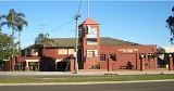
Peakhurst's commercial centres are predominantly located along Forest Road and Boundary Road. Various retail shops, restaurants and cafes are located near the Peakhurst Inn Hotel on Forest Road. The hotel contains a pub and drive-through bottle shop. Peakhurst also contains a sizeable industrial area mainly on and around Boundary Road.Transport
The main roads are Forest Road, Henry Lawson Drive, Stoney Creek Road, Boundary Road, Bonds Road, Broad Arrow Road, Isaac Street, Baumans Road. Forest Road, which links to Henry Lawson Drive at Peakhurst, is the busiest carriagewayCarriageway
A carriageway consists of a width of road on which a vehicle is not restricted by any physical barriers or separation to move laterally...
that extends through numerous other suburbs in Sydney.
Numerous bus companies operate routes through Peakhurst.
Schools
There are four public schools: Georges River College Peakhurst Campus, Peakhurst Public School, Peakhurst South Public School , Peakhurst West Public School.Churches
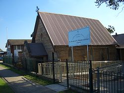
Holy Trinity Anglican Church, Our Lady of Fatima Catholic Church, St Abraam and St Mikhail Al-Behairy Coptic Orthodox Church, Peakhurst Uniting Church, Spanish Evangelical Jerusalem Baptist Church. Samoan Assembly of God Church.Sport and recreation
Popular recreational venues include Grandviews Bowling Club (lawn bowls), tennis courts, Peakhurst Park and the numerous sporting fields located at Gannon's Park. The soccer clubs here are Peakhurst United and Forest Rangers.Demographics
According to the 2006 Australian Bureau of StatisticsAustralian Bureau of Statistics
The Australian Bureau of Statistics is Australia's national statistical agency. It was created as the Commonwealth Bureau of Census and Statistics on 8 December 1905, when the Census and Statistics Act 1905 was given Royal assent. It had its beginnings in section 51 of the Constitution of Australia...
Census
Census
A census is the procedure of systematically acquiring and recording information about the members of a given population. It is a regularly occurring and official count of a particular population. The term is used mostly in connection with national population and housing censuses; other common...
of Population, there were 9,113 people usually resident in Peakhurst. 23.4% stated they were born overseas with the top countries of birth being China 2.9%, United Kingdom 2.7% and Republic of Macedonia 1.4%. English was stated as the only language spoken at home by 7% of residents and the most common other languages spoken were Arabic 4.9%, Greek 4.6% and Cantonese 3.6%. The most common responses for religious affiliation were Catholic
Roman Catholic Church
The Catholic Church, also known as the Roman Catholic Church, is the world's largest Christian church, with over a billion members. Led by the Pope, it defines its mission as spreading the gospel of Jesus Christ, administering the sacraments and exercising charity...
28.1%, Anglican 21.6% and Orthodox
Eastern Orthodox Church
The Orthodox Church, officially called the Orthodox Catholic Church and commonly referred to as the Eastern Orthodox Church, is the second largest Christian denomination in the world, with an estimated 300 million adherents mainly in the countries of Belarus, Bulgaria, Cyprus, Georgia, Greece,...
10.1%.
Politics
The City of HurstvilleCity of Hurstville
The City of Hurstville is a Local Government Area in southern Sydney, in the state of New South Wales, Australia. The city centre is located 17km SSW of the Sydney central business district and west of Botany Bay....
local government area which administers Peakhurst, consists of 12 councillors elected every four years. Peakhurst falls into two Wards of the city: Peakhurst Ward and Penshurst Ward. A further five suburbs are contained wholly or partly in the Peakhurst Ward: Riverwood
Riverwood, New South Wales
Riverwood is a suburb in southern Sydney, in the state of New South Wales, Australia. Riverwood is located 18 kilometres south-west of the Sydney central business district and is part of the St George area...
, Mortdale
Mortdale, New South Wales
Mortdale is a suburb in southern Sydney, in the state of New South Wales, Australia. Mortdale is located 20 kilometres south of the Sydney central business district and is part of the St George area. Mortdale lies across the local government areas of the City of Hurstville and Municipality of...
, Oatley
Oatley, New South Wales
Oatley is a suburb in southern Sydney, in the state of New South Wales, Australia. Oatley is located 21 kilometres south of the Sydney central business district and is part of the St George area...
, Lugarno
Lugarno, New South Wales
Lugarno is a suburb in southern Sydney, in the state of New South Wales, Australia. Lugarno is located 23 kilometres south of the Sydney central business district in the local government area of the City of Hurstville and is part of the St George area....
and Peakhurst Heights
Peakhurst Heights, New South Wales
Peakhurst Heights is a suburb in southern Sydney, in the state of New South Wales, Australia. Peakhurst Heights is located 22 kilometres south of the Sydney central business district and is part of the St George area. Peakhurst Heights is in the local government area of the City of...
.