
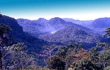
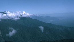
Owen Stanley Range
Encyclopedia
Papua New Guinea
Papua New Guinea , officially the Independent State of Papua New Guinea, is a country in Oceania, occupying the eastern half of the island of New Guinea and numerous offshore islands...
. It was seen in 1849 by Captain Owen Stanley
Owen Stanley
Captain Owen Stanley FRS RN was a British Royal Navy officer and surveyor.-Life:Stanley was born in Alderley, Cheshire the son of Edward Stanley, rector of Alderley and later Bishop of Norwich...
while surveying the south coast of Papua and named after him. Strictly, the eastern extremity of the range is Mount Victoria
Mount Victoria, Papua New Guinea
Mount Victoria is the highest point in the Owen Stanley Ranges in Central Province, Papua New Guinea at 4,072 metres. It lies approximately 75 km north-north-west of Port Moresby and can be seen on a clear day from the city.-History:...
4072 metres (13,360 ft), which was climbed by Sir William Macgregor
William MacGregor
Sir William MacGregor GCMG, CB was a Lieutenant-Governor of British New Guinea, Governor of Newfoundland and Governor of Queensland.-Early life:...
in 1888, and it extends as far west as Mount Thynne and Lilley. But the name is generally used to denote the whole of the chain from Mount Chapman
Mount Chapman
Mount Chapman is a mountain in the Great Smoky Mountains, located in the Southeastern United States. It has an elevation of 6,417 feet above sea level. While the mountain is located deep within the Great Smokies, the Appalachian Trail crosses its eastern slope, coming to within of the summit...
3376 metres (11,076 ft) to the south-eastern end of the island, and to include Mount Albert Edward
Mount Albert Edward, Papua New Guinea
Mount Albert Edward is a 3,990 metre high mountain in the Wharton Range in Central Province, Papua New Guinea. The mountain consists of two peaks about 400 metres apart, a cross marks the top of the slightly higher western peak and a trig station marks the eastern peak...
3990 m (13,091 ft) which is really separated from it by the Wharton Chain.
The range is flanked by broken and difficult country, particularly on the south-western side. There are few practicable passes, the easiest being the famous Kokoda Track
Kokoda Track
The Kokoda Trail or Track is a single-file foot thoroughfare that runs overland — in a straight line — through the Owen Stanley Range in Papua New Guinea...
which crosses the range between Port Moresby
Port Moresby
Port Moresby , or Pot Mosbi in Tok Pisin, is the capital and largest city of Papua New Guinea . It is located on the shores of the Gulf of Papua, on the southeastern coast of the island of New Guinea, which made it a prime objective for conquest by the Imperial Japanese forces during 1942–43...
and Buna and was in use for more than 50 years as a regular overland mail-route. Another route used by the 900 men of the 2nd Battalion, 126th Infantry Regiment, 32nd Division, was the Kapa Kapa Trail
Kapa Kapa Trail
The Kapa Kapa Trail is a steep, little-used, mountain trail that stretches from the Kapa Kapa village on the south coast of Papua New Guinea, across the extremely rugged Owen Stanley Range, to the vicinity of Jaure on the north side of the Peninsula...
, parallel to but 30 miles (48.3 km) to the southeast of the Kokoda Track. They took nearly five weeks to cover the 130 miles (209.2 km) track over extraordinarily difficult jungle terrain, from 14 October to 20 November 1942.
Vehicular roads, though not impossible, would be very difficult and expensive to construct. In fact one was constructed during World War II
World War II
World War II, or the Second World War , was a global conflict lasting from 1939 to 1945, involving most of the world's nations—including all of the great powers—eventually forming two opposing military alliances: the Allies and the Axis...
crossing from Wau in the north to Bulldog in the south and known as the Bulldog track
Bulldog track
The Bulldog Track, also known as the Bulldog-Wau road, in the year 2004 is a foot track crossing the western end of the Owen Stanley Range of Central Papua New Guinea. The track begins near a small settlement on the upper reaches of the Lakekamu River on the south side of the ranges...
. It was largely due to the impossibility of transporting heavy equipment across the range that the Japanese failed to secure Port Moresby as a base early in 1942. The mountains are rough and precipitous, with occasional fertile plateaux which are occupied by native food-gardens.
See also
- Australian EncyclopaediaAustralian EncyclopaediaThe Australian Encyclopedia is an encyclopedia focused on Australia. In addition to biographies of notable Australians the coverage includes the geology, flora, fauna as well as the history of the continent. It was first published by Angus and Robertson in two volumes, one each in 1925 and 1926...
, Vol 6, p. 430, Grolier